DEVELOPING AND IMPLEMENTING A REAL-TIME EARTHQUAKE
NOTIFICATION SYSTEM FOR NUCLEAR POWER PLANT SITES
USING THE USGS SHAKECAST SYSTEM
A.M.Kammerer1, A.R Godoy2, S.Stovall1, J.P.Ake1, A.Altinoyollar3, N.Bekiri3, D. J. Wald4, and K. Lin4 1United States Nuclear Regulatory Commission, Washington D.C., USA
2Formerly of the International Atomic Energy Agency, Vienna, Austria 3International Atomic Energy Agency, Vienna, Austria
4United States Geological Survey, Golden, Colorado, USA
E-mail of corresponding author
ABSTRACT
When an earthquake occurs near a nuclear power plant (NPP), specific information is quickly needed to support accurate real-time situational awareness, assessment of the potential impact to the installation, informed decision making, and effective communication with key stakeholders. To address this important need, the International Atomic Energy Agency (IAEA) and the United States Nuclear Regulatory Commission (NRC), in collaboration with the United States Geological Survey (USGS), are developing and implementing a custom ShakeCast system for post-earthquake real-time notification of ground shaking at NPP sites. The custom system, called Nuclear ShakeCast, is being developed to meet the unique informational needs of the global nuclear community. The project is currently focused on developing and implementing the Nuclear ShakeCast system within the IAEA and NRC. However, the software will be freely available to the international nuclear community once developed.
Nuclear ShakeCast has the potential to incorporate observations, estimates of hazard levels, and plant fragility and license information into real-time automated comparisons of estimated ground motions against plant-specific shut-down criteria and basic NPP damage estimations. The earthquake shaking data used by the ShakeCast system is in the form of a ShakeMap, a map that displays earthquake shaking parameters spatially. If an earthquake occurs and is of sufficient size to trigger automatic creation of a new ShakeMap, the ShakeCast software retrieves the map and automatically begins a series of calculations based on protocols and databases specified a priori by the user. The system then sends an automated notification containing the information needed by key personnel in the response organization. The report includes basic information about the earthquake, the estimated levels of ground shaking calculated for those nuclear installation sites located in the affected region, and NPP design information important in the NPPs licensing basis. All this information–-supported by existing operating international seismological networks—is essential for a quick effective communication and decision making. Depending on the responding organization, communication may be with the effected utilities and NPPs, the regulatory body, the media, the public, and governmental organizations. Rapid and automated information is particularly important because affected organizations are busy dealing with the consequences and disruption caused by the earthquake.
INTRODUCTION
In accordance with both the fundamental safety principles established by the International Atomic Energy Agency (IAEA) and the regulation requirements of the United States Nuclear Regulatory Commission (NRC), appropriate and effective planning and arrangements must be made for emergency preparedness and response for nuclear or radiation incidents. If the initiator of such an incident is a severe extreme natural event, such as an earthquake, those arrangements are critical elements for the reduction of risk at nuclear power plants (NPPs). When an earthquake occurs near an NPP site, information about the earthquake and the estimate of possible levels of ground shaking and the potential for damage at the installation is quickly needed to support accurate real-time situational awareness, informed decision making, and effective communication with key stakeholders. The occurrence of extreme natural disasters in recent years has reinforced the need of having available a notification system that promptly and effectively informs the relevant organization of the potential impact of such events at nuclear installations. The urgent need for a new tool to support automated notification was recognized by both the IAEA and the NRC.
include a series of enhancements to the currently available USGS ShakeCast program [1, 2] that would allow the program to better meet the unique post-earthquake information needs of the nuclear response organizations. The project is currently focused on implementing the Nuclear ShakeCast system within the IAEA and NRC. However, the Nuclear ShakeCast software package will be freely available to the nuclear international community once developed.
The development program discussed herein is a joint program between the IAEA, NRC, and USGS. However, all three organizations had been actively working on elements of what became the Nuclear ShakeCast project prior to the current program. In 2007, IAEA launched the establishment of an “External Event Notification System” within the framework of their extra-budgetary programmes. The IAEA started with a system that used publically available data and reports developed by the USGS applied to the specific location of the operating NPP sites in 31 Member States. Ultimate goals of this notification system were the incorporation of all types of external hazards which potentially may affect nuclear installation sites and development of the ability to provide timely and accurate reports to emergency managers, high level management, media and the public as appropriate. At the same time, the NRC was also working on a in similar notification project and was beginning discussions with the USGS. The similar needs and goals of the IAEA and NRC, coupled with the capabilities and tools of the USGS, created the necessary synergy for a quick development of the first phases of the system.
OVERVIEW OF THE SHAKECAST SYSTEM
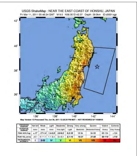
The name “ShakeCast” is a shortening of the term “ShakeMap Broadcast”. ShakeMaps ([3], an example of which is shown in Figure 1) are tools that display earthquake shaking parameters spatially. ShakeCast, the system on which Nuclear ShakeCast is built, was developed as a tool to allow more effective use of USGS products— particularly ShakeMaps—by a wide range of critical user organizations. ShakeCast is a post-earthquake notification application that is implemented within a user organization and is customized based on the needs and the portfolio of facilities of interest to the organization.
If an earthquake occurs and is of sufficient size to trigger automatic creation of a new ShakeMap, the ShakeCast software retrieves the map and automatically begins a series of calculations and actions based on protocols and databases specified by the user a priori. The system compares ground motion intensity measures from the ShakeMap against the relevant data (e.g., fragility curves and design ground shaking values) for facilities of interest in the impacted area, sends email notifications of potential damage to responsible parties in the user organization, and generates facility damage assessment maps and other Web-based products for key staff, such as emergency managers and responders. Although the system is a post-earthquake application, the system must be installed and operating within a user organization at the time of the earthquake. This pre-earthquake implementation includes development of a database that includes all the relevant parameters for the facilities of interest.
THE NUCLEAR SHAKECAST DEVELOPMENT AND IMPLEMENTATION PROGRAM
The ShakeCast system described above was developed based on the needs of critical users with large inventories of conventional structures and infrastructure. The currently available version of ShakeCast already incorporated advanced features for users as a result of cooperative work between the USGS and the California Department of Transportation (Caltrans). These features are particularly useful when an organization has a significant portfolio of facilities in an affected region and must determine where to focus limited resources. In this case understanding which structures (e.g., bridges and overpasses) are likely to be the most damaged is extremely valuable.
Shaking Level 1 (SL-1) and Shaking Level 2 (SL-2) ground motions. The system is capable of handling either terminology.
The possible enhancements identified for Nuclear ShakeCast fall into three categories: functional enhancements, user interface enhancements, and usability enhancements. The functional enhancements include new features such as the addition of regulatory design parameters (e.g., OBE and SSE or SL-1 and SL-2) and soil amplification information in the database and notification, additional GMPE’s, additional spectral periods, and multiple threshold notifications for different users groups (e.g, seismic experts versus incident/emergency response center staff). User interface enhancements include an expansion of the standard notification to include information that is currently readily available, such intensity scale plots, source specific data such as magnitude type and hypocenter depth, information on the country to which the event is associated, and incorporation of data from other USGS products (discussed below). Usability enhancements include improvements to the home page communication tools and changes to make the notifications more smart phone friendly.
The development and implementation of the Nuclear ShakeCast system is being undertaken in several stages. These include the following:
• Basic enhancement of the original ShakeCast system by USGS for IAEA and NRC use (completed)
• Development of an IAEA global database (completed) for all NPP sites and nuclear reactor units and enhancement for US NPPs by NRC (underway)
• Security testing of the original ShakeCast system using NRC protocols (completed)
• Implementation and beta-testing of enhanced ShakeCast system in the IAEA (completed) and NRC (underway)
• Development of proposed final enhancement specifications by IAEA and NRC (underway)
• Implementation of enhancements to create final Nuclear ShakeCast system by USGS (underway)
• Implementation and testing of Nuclear ShakeCast in the IAEA and USGS
• Public release of Nuclear ShakeCast
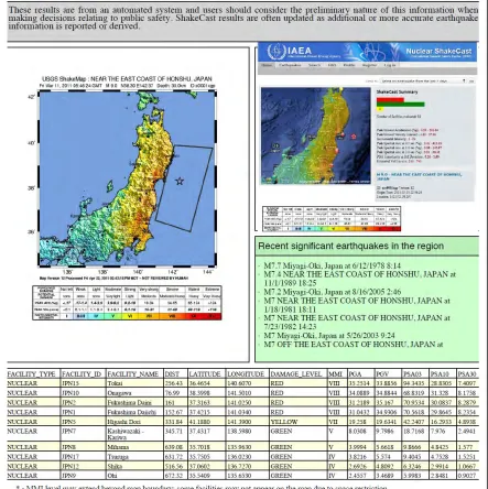
At the time of this writing significant progress has been made and IAEA and NRC staff are beta-testing an IAEA version of the original enhanced program. The final version of Nuclear ShakeCast is not yet in production mode, and many of the final enhancements have not yet been implemented. However, the value of this program was demonstrated in March 2011 when IAEA and NRC staff received automatic notification of a major earthquake off the coast of Japan. Figure 2 shows the notification received by key IAEA and NRC staff that alerted them to the potential for damage at operating NPPs in Japan. (It should be noted that the fragility curves in the current system are generic curves that are used for beta-testing purposes only.)
ABOUT SHAKEMAPS AND THEIR DEVELOPMENT
As discussed, ShakeMaps are key input to the ShakeCast system. If an earthquake occurs, and exceeds the specified minimum magnitude of 5.5, the creation of a new ShakeMap by the USGS National Earthquake Information Center (NEIC) and/or its partners is automatically triggered. ShakeMaps are developed using both instrumental data and data from Did You Feel It? [4] responses that are submitted by residents in the impacted area (DYFI? is discussed in more detail below).
The principal seismographic network system used to collect the instrumental data in the US is the Advanced National Seismic System. For earthquakes outside the US, the NEIC uses data collected by the Global Seismic Network (GSN). These systems allow the NEIC to produce an estimate of both ground motion and intensity levels resulting from an earthquake. ShakeMaps are produced principally using instrumental data. However, the intensities are refined as necessary based on information collected by the DYFI? system.
INCORPORATION OF OTHER USGS PRODUCTS
The USGS produces additional post-earthquake products that relay critical societal information useful to responders. These products include DYFI? and PAGER (Prompt Assessment of Global Earthquakes for Response) [5] reports, both of which can significantly increase awareness of the regional situation for decision makers. The Nuclear ShakeCast system will integrate the products more directly into the automatic notification than is the case in the currently available ShakeCast system. Importantly for the NRC, the automated receipt of the most current information from the USGS assures consistent information is available.
DYFI? is a USGS product that develops Community Internet Intensity Maps (CIIM) based on information provided by residents in an affected area. The information is collected when residents visit the USGS website and answer a series of questions related to their experience in the earthquake and any damage that occurred. CIIMs assign an intensity value to each community that reflects the direct measure of the impact of an earthquake on residents. PAGER provides the user organization with critical situation awareness, including predictions of fatalities, financial impact, loss of housing, and impact to regional transportation and other infrastructure. An example PAGER notification is shown in Figure 3.
The USGS also maintains a digital library of ShakeMaps of past earthquakes called the Atlas of Global ShakeMaps. This Atlas includes nearly 5,500 historical US and global earthquakes that have occurred since 1973. The ShakeCast system can chart these significant historic earthquakes in the region around an NPP and provide a prediction of what the impact of the earthquakes would have been at the NPP site. As part of this project, the USGS reviewed the Atlas of Global ShakeMaps and compiled a database of shaking history at existing and potential NPP sites. This new database allows users such as IAEA to gain insights into the possible hazard and risk at a particular NPP site, in addition to preparing the site for post-earthquake response.
Although not part of the Nuclear ShakeCast system, ShakeCast Lite is a simple program that may be of interest to some readers. ShakeCast Lite is available for download at the USGS website, is easy to install, and automatically notifies the user of the creation of a new ShakeMap.
USE OF NUCLEAR SHAKECAST WITHIN THE IAEA AND THE US NRC
Although some needs of the IAEA and the NRC related to post-earthquake notification differ due to differing roles of the agencies, many of the most important needs are substantially the same. Additionally, the implementation and use of the Nuclear ShakeCast tool within both agencies are similar. Therefore, it was determined that one version of the Nuclear ShakeCast program that met the needs of both agencies should be developed. As a result, the development of the list of proposed enhancements for the Nuclear ShakeCast system was developed jointly by IAEA and NRC technical staff. In both organizations, the Nuclear ShakeCast system is being developed and implemented by agency seismic specialists involved in post-earthquake response working in conjunction with appropriate information technology (IT) experts. In both organizations, the use of the ShakeCast system and the distribution of the notifications is limited to two types of staff: key seismic technical staff and emergency response personnel working with each agency’s operations center.
The Nuclear ShakeCast tool is focused on real-time response and situational awareness. Therefore, in developing the notifications, significant attention was given to interdisciplinary data integration that can support the rapid decision making needed early in a crisis. The tool is not intended to be used for longer-term regulatory action or post-event technical assessments. Because both the IAEA and NRC have implemented a database that includes all operating NPPs, Nuclear ShakeCast is a useful tool for post-earthquake situational awareness on a global scale. However, this tool should enhance—not replace—current protocols and procedures implemented by individual NPP utilities, and regulatory authority. Further, Nuclear ShakeCast should be used in a manner consistent with any specific national legal and licensing rules and requirements. In the US, shaking data recorded by the on-site seismic monitoring system at an impacted NPP will supersede the ShakeMap ground shaking data as soon as the site-specific data is available.
INFORMATION SECURITY
Information security is essential for any organization that controls sensitive or proprietary data. The approach to information security used in the development of ShakeCast has significant benefits to the nuclear community, which typically deals with sensitive information. Because the database used by the ShakeCast system, as well as the system itself, is available only within the user organization, the organization itself always maintains control of the data using its own protocols. The only outside information required for successful operation of the system is the relevant USGS ShakeMap, which is made available by the USGS through a Really Simple Syndication (RSS) feed. By using an RSS feed, the user organization “pulls” the USGS data in, and no “push” into the organization’s servers is required. At no time does the USGS have access to the user organization’s database or the results of any calculations performed by ShakeCast. The user organization is fully responsible for the appropriate implementation and use of the software and data at all times. As noted above, both the NRC and IAEA generally limit real-time distribution of their in-house ShakeCast notifications due to the uncertainty of the results and sensitivity of the contents.
MOVING FORWARD
As with the current ShakeCast system, the Nuclear ShakeCast software package will be freely and publically available for download through the USGS website once developed and tested. Although, the system was designed to meet the needs of nuclear facilities, the system can be used for other critical facilities, such as liquefied natural gas power plants and terminals, petrochemical plants, conventional thermal power plants. Possible future enhancements could include alerts for both tsunami and volcano hazards that could potentially affect the safety of nuclear installations.
SUMMARY
The IAEA and the NRC, in collaboration with the USGS, are developing and implementing a custom ShakeCast system for post-earthquake real-time notification of ground shaking at NPP sites that is focused on the unique informational needs of responding organizations. Nuclear ShakeCast has the potential to incorporate observation, prediction, and plant fragility and license information into real-time automated comparisons of estimated ground motions against plant-specific shut-down criteria and basic NPP damage estimations. The resulting Nuclear ShakeCast report, which can be automatically sent to key staff within a user organization, will include basic information about the earthquake and predicted levels of ground shaking at impacted NPPs, in addition to information important to the NPP’s licensing basis.
Once the development and implementation of this notification system is completed, in a matter of few minutes after the occurrence of an earthquake in any part of the world, key agency users will be notified about NPP sites that may have been affected, the estimated intensity levels experienced at the sites, and a comparison of the shaking against the plant design levels. Thus, Nuclear ShakeCast will serve as a unique and significant tool to support real-time communication and response at national and international levels when earthquakes occur.
REFERENCES
[1] Lin, K., and D. J. Wald (2008). ShakeCast Manual, U.S. Geol. Survey Open File Rep. 2008-1158, 90 pp. [2] Lin, K., and D. J. Wald (2010). Using ShakeMap and ShakeCast for Post-Earthquake Response and Damage
Assessment, Ninth U.S. National and Tenth Canadian Conf on Eq. Engineering, Paper 533, 10 pp.
[3] Wald, D. J., B. C. Worden, K. Lin, and K. Pankow (2005). "ShakeMap manual: technical manual, user's guide, and software guide." U. S. Geological Survey, Techniques and Methods 12-A1, 132 pp.
[4]