On the Geomorphology and Tectonic Position of
Ciletuh-Jampang Area, West Java, Indonesia
Iyan Haryanto, Adjat Sudradjat
*Faculty of Engineering Geology, Padjadjaran University, Bandung, Indonesia
Copyright©2018 by authors, all rights reserved. Authors agree that this article remains permanently open access under the terms of the Creative Commons Attribution License 4.0 International License
Abstract
The Ciletuh-Jampang area is located in the western tip of the Southern Mountain of West Java, Indonesia. The area is presently well publicized in an effort to bring the unique geological characteristics exposed in this particular place to become the Global Geopark Network (GGN) of UNESCO. Ciletuh area exhibits a rare mega-aphitheater morphology. Stratigraphically West Java composed of clastic sediments of continental and volcanic island arc origin with the interruption of sub-aerial volcanic rocks and the coastal reefs banks developed along the coasts both in the north and the south. The age of the rock ranges between Eocene to Recent. The analysis of regional structure shows that a set of deep seated faults was recognized dominating the area in NNW-SSE and NNE-SSW directions. The released faulting occurred in E-W direction. The low angle shallow upthrustings facing north of skin structure in E-W direction dominate the upper part of the rock sequence. The structural analysis revealed the continuous prevailing stress field in SSW-NNE direction since Eocene time. The advancing landslides are readily observable in the rim of the amphitheater of Ciletuh. This phenomenon seems to demonstrate the initial stage (primarumpf) of the geomorphologic cycle taking into account the flat surface of Jampang area in the surroundings. Further investigations revealed the geomorphologic evidences of the formation of plateau, namely the erosion surface, old terraces, mountain tables, old beach ridges and the characteristics of drainage pattern. Two remnants of main plateau were recognized in Ciletuh-Jampang area, namely Bentang Plateau and Jampang Plateau. Further investigations show that at least five locations of plateau were identified in western part of Java Island, namely Dieng Plateau (+ 2,000 m), Pengalengan Plateau (+1,300 m), Bentang Plateau (+ 1,000 m), Jongrangan Plateau (+ 850 m) and Jampang Plateau (+ 700 m). A rough estimation reveals the annual rate of lifting in Java Island since Pliocene time ranges most likely between 5.0 and 5.4cm.Keywords
Amphitheater, Initial Stage, Plateau,Uplifting, Skin Tectonics
1. Introduction
Ciletuh-Jampang area is located in southern part of West Java. Geographically it extends from the longitudes of 106020’ to 107000’ East and the latitudes of 07000’ to 07045’ South (Figure 1). To the west the area is bounded by Banten Province, to the South by the open sea of Indian Ocean, whilst to the North and East it has common boundaries with Bogor and Cianjur Residencies respectively. The area is located about the same distances from Jakarta, the capital city and from Bandung the Province city, namely 125 kilometers away.
The investigated area is covered mainly by rubber and tea plantations. Recently the coconut palm replaces the old rubber plants. Due to the difficult access the area remains relatively virgin. The rare turtle of the Indian Ocean used to lay their eggs in the white sandy beaches in the investigated area. Fishermen live in the embayment of the coastal area. The arable land is limited to the valleys in the vicinity of the coast.
The off-road vehicle is the mode of transportation from Pelabuhan Ratu a local fisherman’s harbor located about 25 kilometers NNE of the investigated area. The other access is by fishing boat directly from Pelabuhan Ratu. In the rough sea at the western monsoon however, the sea transportation might be inconvenient.
The terrain mostly consists of rugged topography, geologically known as Southern Mountains. At the crest of the mountain, a rather flat topography however exists. The Southern Mountain composes of Miocene volcanics with the interruptions of clastics sediments deposited in the shallow marine environment. An escarpment of Cimandiri fault bounds the topography from the relatively smooth Quaternary volcanic terrain in the North.
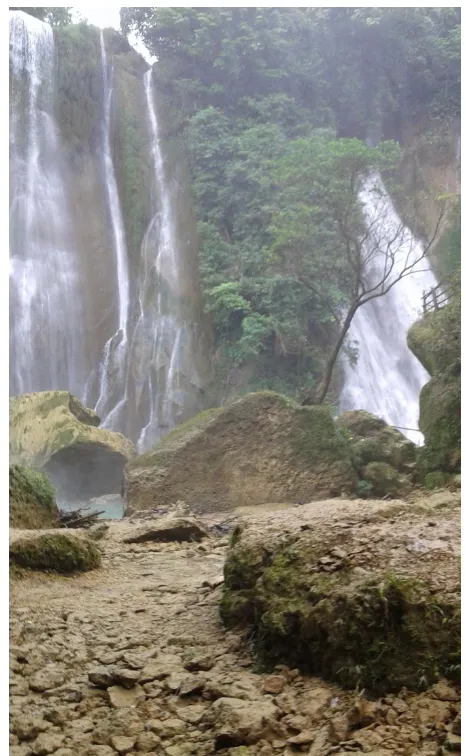
Geopark Network (GGN) of Unesco. Although it is at a very initial state, many institutions including local government, supporting the proposal, taking into account the beautiful panorama available in the area. A mega-amphitheater, surrounded by waterfalls, presents an impressive view rarely found. Furthermore, from the geological point of view, the typical rocks of oceanic crust exposed in this area indicate the boundary between the continent and the ocean in the Eocene time or 50.1±2.1 Ma ago (Schiller et al., 1991)[1]. The melange assemblages strongly support the evidence of the ancient subduction in this area. Hence the delineation of tectonic boundary between Eurasian continent and the Indian oceanic crust might be located. The rocks date back to Eocene time represents the basement of Java Island, where a pile of younger rock sequences of Upper Tertiary age laid on. The oldest rock in West Java area based on the borehole’s sample indicated the age of 213±11 Ma or
Triassic (Haryanto, 2014)[2].
[image:2.595.60.540.315.671.2]Many authors among others Martodjojo et al. (1978) [3], Noeradi (1997) [4], Thayib et al. (1977)[5] published the papers about the geology and geomorphology of the investigated area. A tectono-stratigraphy study was carried out by Hakiki (2012) [6] to reveal the tectonic position of melange assemblages under the Tertiary volcano-clastic sediments. Earlier, Suparka (1996) [7] focused the investigation on the petrology and chemical composition of the volcanic rocks in Ciletuh and its vicinity as the key to uncover the tectonic evolution of West Java. Detailed petrographic descriptions of the rock exposed in Ciletuh area were presented by Abdurrahman & Rosana (2014) [8] in their recent publication. The results of those investigations pointed out the strong indication of the ancient subduction zone occurring in Ciletuh-Jampang area.
2. Methodology
The previous studies and the systematic geological maps of Ciletuh and Balekambang quadrangle with the scale of 1:100,000 prepared by Sukamto (1975)[9] has provided the ground truth information for the present authors in the interpretation of the geomorphology and tectonic position of Ciletuh-Jampang area. The RSTM satellite image outlines the synoptic view reflecting the clear picture of the geomorphologic and structural phenomena. The field work particularly carried out by the first author collected detail information on the geological evidences.
For the seek of regional analysis concerning the tectonic activities, the investigated area was extended as far as the entire zone of West Java. The evidence of plateau features was compiled from the localities in western part of Java Island, namely from West Progo in the east and Pelabuhan Ratu in the west. The extended investigation in the area further North of West Java gave a better understanding of the regional tectonics taking place in the period of Eocene to Recent.
The fracture patterns and micro-tectonic structural features are the main objects of data collection in the field. The strike and dip measurement was plotted in the rosette diagram and upper hemisphere projection. The result is presented in graphical method showing the general direction of regional structure in the sequence of time. The measurement on topographic map and satellite images provide the information on the position of the slope and altitude of the plateau. The available data based on deductive method determining the age of the rocks involved in the formation of the plateau resulted in the estimation of the uplifting rate of the plateau since
Pliocene time.
3. Results and Discussions
The lithology of Ciletuh-Jampang area consists ot he oceanic crust and the assemblages of melange deposits. The K-Ar determination revealed the age of Eocene about 50.1±2.1 Ma (Schiller et al., 1991)[1]. It is therefore concluded that the ancient subduction of Eocene age took place in this region. The rocks resemble that of Lok Ulo area in Kebumen, Central Java. Sukendar (1974)[10], speculated that melange of Lok Ulo strongly correlated with that of Meratus Mountain in South East Kalimantan. Hence the boundary of Ancient Eurasian continent extended from Ciletuh and Lok Ulo to Kalimantan. The open sea existed southeast of the boundary and the ancient continent located in the north. Hall, et al. (2007)[11] was in the same opinion. Haryanto (2014) [2] proposed the skin tectonics above the continental crust basement in western part of Java.
[image:3.595.55.541.515.696.2]The stratigraphic sequence of the rocks in the investigated area started with the formation of melange of Eocene age frequently known as Ciletuh Formation (Table 1). It consists of clastic sediment with fragments of schist, quartz, mica and tourmaline. It is strongly folded and partly metamorphosed. The basement composes of schist and metamorphosed ultra-basaltic rocks. The age was determined by Schiller et al. (1991)[1] showing the age of 134.0±3.0 or Cretaceous. The formation is followed by Bayah Formation consisting of quarts, sandstone, marl, clay, tuff and thin coal seams. It contains Assilina pelatispira, Discocyclina and Camerina indicating the age of Oligocene.
Table 1. Simplified stratigraphic column of the investigated area (compiled from various sources)
Age Formation Description Fossils content
Upper Miocene
Bentang
Formation Sandstone, lignite, gravel, titano-magnetic sands Globigerina, Cycloclypeus sp. Beser
Formation Volcano-clastics, conglomerate, clay Turritella annulata cramatensis MARTIN
Middle Miocene Cimandiri
Formation Reef limestone, sandstone, clay
Miogypsina indonesiensis TAN, Cycloclypeus annulatus MARTIN
Late Oligocene – Early Middle Miocene
Jampang Formation
Tuff, marl, sandstone, breccia, calcareous tuff, limestone
Trillina howchini,Miogypsina thecidaeformis RUTTEN, Cycloclypeus
annulatus MARTIN Oligocene
(unconformity)
Bayah
Formation Quartz, sandstone, marl clay, tuff, thin coal seams
Assilina pelatispira, Discocyclina, Camerina
Eocene (unconformity)
Ciletuh Formation
Clastic sediments with fragments of schist, quarts, mica, tourmaline, partly metamorphosed (melange
assemblage)
---
Mesozoic Basement Schist and metamorphosed ultrabasic rocks (oceanic
crust) ---
Those fossils indicate the age of Middle Miocene.
Finally, Beser Formation laid upon the sequence of Cimandiri Formation. The formation is characterized by fluvial deposits indicating the beginning of the uplifting. It consists of volcano-clastics, conglomerate and clay containing
Turritella angulata cramatensis MARTIN of Upper Miocene. The formation is closely associated with the overlying Bentang series consisting of sandstone, lignite, gravel and titano-magnetic sand indicating the erosion commencing the peneplaination process. Marly tuff contains Globigerina. In the clay lenses Cycloclypeus sp. were found indicating the age of Upper Miocene. The uplifting and peneplaination took place by the end of Miocene or the beginning of Pliocene until Present day.
[image:4.595.86.512.252.512.2]The rocks of oceanic crust compose of basalts and peridotites in intimate relation with deep marine deposits. The pillow lava structure appears in some places at the beach cropping out due to the sea water abrasion. Red chert layers alternated with fine sandstone commonly expose. The strong tectonics of the area produced the steep dip of the layers. In some places the angle reaches almost vertical. Such structural position creates a beautiful alternation of hard red chert and white soft sandstone found in many places in Ciletuh area. Local people identify the rocks as the back of the sea dragon. The beautiful surface exposed by the rocks might be one of the unique geomorphologic phenomena in the area (Figure 2).
Figure 2. The alternation between soft white sand and hard red chert exhibits the unique morphology of the rock
The regional stratigraphy of West Java shows the rock composition dominated by clastic materials alternating between fine and coarse grain size. The volcanic materials are embedded in the clastic sediments. Marl and calcareous fine grain sandstone alternating with clays and mudstone commonly present. In general it shows the characteristics of flysch facies. Martodjojo (1984)[3] described the rock sequence in detail and found out that the rocks were deposited under the sea in fan-like environment. Dam (1994)[12] on the other hands concluded that the rock sequence might have been deposited in the elongated narrow basin south of the Eurasian continent. The materials initially came from the continental crust in the north at the Eocene age and with the existence of the volcanic arc in the south by the end of Eocene and Early Oligocene, the materials came from both sides. Volcanic activity took place at the volcanic arc and formed the presently known Southern Mountain. The rocks consist of andesite and in
some places intruded by dacite and basaltic rocks. The sub-aerial volcanic rocks were deposited in the island arc and supplied materials to the narrow basin in the north. In shallow sea off the ancient continental coast developed coral reefs. In the south, the reef grew earlier before the sea water condition contaminated by the volcanic materials produced by the island arc.
peneplaination commenced to took place.
Table 2. The significant dip discrepancies between Bentang Formation, Beser Formations and Cimandiri Formation
Bentang Formation (youngest)
Beser Formation (Younger)
Cimandiri (older)
Strike Dip Strike Dip Strike Dip
70 2 135 13 275 50
90 3 135 10 215 45
90 3 125 1 300 20
90 3 130 17 85 20
80 4 115 5 100 54
90 3 125 8 90 48
85 5 115 13 130 70
90 2 130 3 110 20
115 4 5 18 290 20
45 3 90 10 310 25
For the stratigraphic position refers to Table 1
From the measurements of the dip and strike of the sediments in the course of the age from Upper Eocene to Pliocene resulted in the consistent movement of the dip axis toward the center of the upper hemisphere projection (Figure 3). It might be interpreted that the uplifting continuously occurred leaving the younger formations of Bentang and Beser remained flat. During the deposition tectonic activity took place and continued from Oligocene to present times.
[image:5.595.54.294.122.301.2]The strike of the sediments remain at the same azimuth which was interpreted that the tectonic pressure was consistent in the direction of N5-25E. The first phase produced a set of faulting in Early Miocene which at present appear as deep seated faults (Haryanto, 2005)[12]. The second phase of tectonic activity resulted in shallow folding and faulting. The deep seated faults dominated the NNW-SSE and NNE-SSW directions. The strikes are dispersed in Pliocene rock formation due to the horizontal nature of the layers. This tectonic activity characterized the uplifting in Ciletuh-Jampang area. On the other side of the crest, Java anticline showed totally different situation, where the younger formations tend to slide down forming the upthrusting. The structure involved the upper part of the sequence, therefor skin tectonics was introduced (Haryanto, 2014)[2].
Figure 3. The result of strike and dip measurements shown in rosette diagram and upper hemisphere projection
Figure 4. Schematic N-S cross-section of Java Island
[image:6.595.85.517.111.279.2]Those plateaus locate at various altitudes. Dieng plateau lies at the altitude of 2,000 meters, Pengalengan 1,300 meters, Bentang 1,000 meters. Jongrangan 850 meters and Jampang 700 meters (Table 3). In Jampang Plateau at least five rows of old beach ridges containing iron sand were identified. Terraces are also found among othres in the river banks of Cikaso demonstrating the recent uplift. Table mountains in Jampang Plateau represent the remnant of peneplain surface (Figure 5). Based on the age of the rocks involved in the uplifting of Pliocene age, it is interpreted that the annual rate of the lifting most likely between 5.0 to 5.4 centimeters.
Table 3. The location and altitudes of the plateau
Name Altitude (m) Location
Dieng 2,000 Central Java
Pengalengan 1,300 West Java
Bentang 1,000 Ciletuh-Jampang
Jongrangan 850 Central Java
Jampang 700 Ciletuh-Jampang
Ciletuh-Jampang Plateau occupied the southern part of the investigated area. It thus locates in the southern flank of the anticline. Bentang plateau locates almost at the crest of the anticline. The intensive eroded valleys delineate both the plateaus. At the west edge of Jampang Plateau the initial stage (primarumpf) of the erosion takes place. It expresses the beginning of the new geomorphologic cycle after the formation of Jampang Plateau in Pliocene time. The erosion activity produced mega-amphitheater feauture of Ciletuh area. The upstram erosion can be easily observed in the beds of the rivers draining into the amphitheater.
[image:6.595.86.510.419.506.2]Figure 5. The Table Mountains of Ciletuh-Jampang and the old beach ridges
[image:7.595.180.413.357.735.2]4. Conclusions
In the investigated area the remnant of the plateaus are identified, namely Jampang and Bentang. Such a plateau also occurs in Pengalengan, Dieng and Jongrangan at various levels of altitude. The phenomena indicate the interrupted uplifting of Java Island which provided opportunity for peneplaination.
The tectonic position of Ciletuh-Jampang area is at the southern flank of the E-W trending main anticline of West Java. Based on the position of the plateau the annual rate of uplifting was estimated between 5.0 and 5.4 cm since Pliocene time. The unique Ciletuh amphitheater reflects the initial phase of the geomorphologic cycle, hence the sliding and the circular extension of the rim might continue in the future.
Further investigation is needed to carefully examine the occurrence of the plateau in entire parts of Java. The information would significantly contribute to the understanding of the tectonic development of Java Island.
Acknowledgements
The authors wish to express their gratitude to Padjadjaran University for the permission to publish the results of the dissertation of doctorate degree. This paper has been presented at the Asia Oceania Geological Society held in Singapore, August 4-7, 2015, as part of the result of the research funded by Padjadjaran University. Votes of thanks subsequently are due to the University. The authors also wish to extend the gratitude to Professor Mega Fatimah Rosana and Ron Agusta who have generously contributed the photograph of the beautiful alternating soft white sands and the hard red cherts layers.
REFERENCES
[1] Schiller, D.M, Garrard, R A and Prasetyo, L, Eocene submarine fan sedimentation in Southwest Java, Indonesia, Petroleum Association Proceedings, 20th Annual Convention, p. 125-182, 1991
[2] Haryanto, I, Tectonic evolution of Western part of Java
Island, during Cenozoic, Dissertation, Padjadjaran University, repository, 2014
[3] Martodjojo, Sujono, The evolution of Bogor Basin, West Java, Dissertation, ITB, repository, 1984
[4] Nuradi, N, The evolution of Paleogene basin in Ciletuh area, southern part of West Java, Bulletin of Geology. V. 27, n. 1/3, ITB, 1997
[5] Thayib, E S, Said, E L, Siswoyo and Priyomarsono, S, The status of melange complex in the Ciletuh area, South West Java, Indonesian Petroleum Association, Proceedings 6th Annual Convention, p. 242-254, 1977
[6] Hakiki, G F, Tectonostratigraphy of Ciletuh and its vicinity, thesis, Padjadjaran University, repository, 2012
[7] Suparka, M E, Petrology of chemical pattern characteristics of volcanic rocks in Citirem Formation: a key to refine the synthesis of the tectonic development in West Java, Research Institute, ITB, 1996
[8] Abdurrahman, Oman and Rosana, Mega Fatimah, The tune of the earth: Ciletuh-Jampang, Geological Agency, 171 p., 2014.
[9] Sukamto, R., Geologic map of Jampang and Balekambang Quadrangles, Java, scale 1:100,000, Geological Research and Development Center, 11 p., 1975.
[10]Sukendar, Asikin, The geologic evolution of Central Java and adjacent areas with reference to the New Global Tectonic Theory, Dissertation, ITB, unpublished, 1974
[11]Hall, R., Clements B, Smyth, H R, & Cottam, M A, A new interpretation of Java’s structure, Proceeding, Indonesian Petroleum Association, 31rd Annual Convention, p. 125- 181, 2007
[12]Haryanto, I., The collided tectonic plates of Java Island: A review on the position of subduction in Java, Bulletin of Scientific Contribution, Geology, Padjadjaran University, 2005
[13]Pannekoek, A.J., The geomorphologic reconnaissance of Jampang Plateau, West Java, TKNAG, 63,3, The Netherlands, p. 340-367, 1946
[14]Sulaksana, Nana, Tectonic control of the morphometry on the Tertiary sediments and Quaternary volcanics of Sunda volcano in Subang and Purwakarta regencies, West Java, Dissertation, Padjadjaran University, repository, 243 p. 2011, 2011