Assessing the Ecological Declining and Natural Disaster
Situation of Hilly Area: A Case Study of Bandarban Sadar
Upazila, Bangladesh
Subir Kumar Das
*, Md. Moniruzzaman, Md. Majedul Bari
Dept of Geography & Environment, Jagannath University, Dhaka-1100 *Corresponding Author: Subir785@gmail.com
Copyright © 2014 Horizon Research Publishing All rights reserved.
Abstract
Most of the indigenous peoples of Bangladesh have been living in the Chittagong Hill Tracts (CHT) especially in Bandarban district since a long time ago. The accompanying study “Assessing the ecological declining and environmental degradation situation of hilly area” has been conceived for a comprehensive understanding the ecological declining and environmental degradation status of the people living in the Bandarban. The purposes of this study are to estimate the present status of food availability and environmental degradation of the Bandarban District, to develop a system dynamics model to simulate food security and environmental degradation at upazila and district level and to address the different management strategies and development scenarios. This research is carried out using primary data including field observation, questionnaire survey, GPS data, official documents etc. and published documents. A total of 150 households were chosen from 7563 households using Raosoft sample size calculator. Advance statistical software i.e. SPSS has used for data entry and analysis. The research found that about 24.67% of the household said that the main disaster risk is land slide. And they are facing this frequently of several years. Other natural disasters are flood (44.67%), cyclone (18.67%), flash flood (10.66%) etc. Last 5 years they have to face flood at higher amount (44.67%), land slide 20.67% and flash flood 12.67%. So the disaster risk is increasing. People blamed increasing disaster risk due to hill cutting soil erosion, deforestation, faulty agricultural practices, etc., for the land- slides. Govt. and NGOs reduce hill cutting and take measures to reduce deforestation.Keywords
Ecology, Environmental Degradation, Deforestation, Flash Flood1. Introduction
Bangladesh is a developing country of third world. The
2011 Census counted 149,772,263 people with a land area of 147,570 sq. km. Bangladesh is one of the most densely populated (1,015 per sq.km) country of the world [7]. Bandarbanis a district in South-Eastern Bangladesh, and a part of the Chittagong Division and Chittagong Hill Tracts. Bandarban (meaning the dam of monkeys), or in Marma or Arakanese language as "Rwa-daw Mro" is also known as Arvumi or the Bohmong Circle (of the rest of the three hill districts Rangamati is the Chakma Circle and Khagrachari is the Mong Circle). Bandarban town is the home town of the Bohmong Chief (currently King, or Raja, Aung Shwe Prue Chowdhury) who is the head of the Marma population. It also is the administrative headquarter of Bandarban district, which has turned into one of the most exotic tourist attractions in Bangladesh since the insurgency in Chittagong Hill Tracts has ceased more than a decade back.
The area is hilly covered with thick vegetation. It is physically constituted with earthen and rocky hills, forests, waterfalls, rivulets (chara) and river valleys. Alongside the hill ranges, small and thin plain strips run. The two rivers, namely Sangu and Matamuhuri in the south are flowing across the district and enrich the soil. The highest mountain peak of the country is called “Tozingtong” (Bijoy Pahar) which is 4500 feet high and located in Bandarban district [1]. Ecological characteristics dominated this hilly region very much. but at present due to overconsumption of ecological resources environment of this hilly region are now at underlying risk. Environmental degradation occurs very much in this region.
2. Objectives
The study has been carried out in order to achieve the following objectives.
to estimate the present status of food availability and environmental degradation of the Bandarban District
upazila and district level
to address the different management strategies and development scenarios
3. Limitations of the Study
Every research has some limitations. This research is not an exception of this rule. Firstly, for this study we have collected data from the Bandarban Sadar upazila only. Beside this, only nine groups of ethnic people were included in the study population. There are many ethnic communities of different races that are scattered in many places of Bangladesh. Thus data are only for one ethnic community of Bandarban sadar upazila that does not represent the whole ethnic communities of this country and the results cannot be generalized.
Secondly, here data were not collected proportionately for different races. Time was not enough to conduct the research properly. Finally, this was a self-financed study, which limited the various scopes along with the scope of extending the study area and increasing the sample size.
Figure 1. Study area Map (Bandar ban Sadar upazila)
3.1. Data Source and Methodology
Both primary and secondary data are used for this study. Questionnaire survey, key informant interview, focus group discussion technique are used for collecting primary data. Books, journals, report, thesis paper, newspaper article etc. are the sources for secondary data.
The total research design has been split into two broad segments namely; Quantitative Survey, Qualitative Study and those are sequenced below. The key dimensions of the Quantitative Survey Methods and then Qualitative Study Methods are presented below. Total 150 sample households were taken from different villages of Bandarban sadar upazila(Shown in Figure 1).
The data collection strategies included all possible techniques and methods in order to ensure the highest level of participation from household level, government officials, and traditional leaders to get in-depth feedback from the individuals’ interviewees and community people. Stakeholder Consultation Meetings was arranged at the Bandarban sadar upazila before the main fieldwork. All the samples are clustered in different villages in Bandarban sadar upazila. There was variation in the number of Field Investigators actually deployed in a team depending upon the actual workload and situation of the field. On completion of field data/information collection phase to get some qualitative information which can substantiates quantitative data/information on the basis of field level observation and experiences.
4. Result & Discussion
4.1. Profiles of the Households
About 48% of the household heads of the households belong to the age group of 50-60. This analysis shows that about 25.67% of the household heads belong to age group (40-50) in which is shown in Table 1. Overall the mean age of the household heads is about 52 years and minimum 28 & maximum 84. About 40% of the household heads have reported having no Education. About 34% have completed primary education, 10% lower secondary, 6.67% secondary, 3.33% SSC and 6% above (Table 1). Analysis suggests that agriculture is the primary occupation of 63.33% of the household heads including plain land and jum cultivation and secondary occupation. While 20% of the household heads is non-agri-laborer. about 8% are primarily engaged in business and 8.67% on secondary (Table 1).
4.2. Ecological Facilities
[image:2.595.57.303.344.712.2]enough (70%). The salient fruit species are lemon, orange, banana, mango etc.
Table 1. Background information of the households (N=150)
Variables Percentage (%)
Age in year (N=150):
<10 1.33
10-20 44.67
21-30 20.67
31-40 12.0
41-50 12.67
50+ 8.67
Education (N=150):
Under age 6.67
No Schooling (above 6 years) 40
One – five 34
Six – eight 10
Nine – SSC 3.33
HSC-Masters 6
Main earning source (N=150):
Agriculture 63.33
Business 8
Day Labour 20
Service 8.67
Source: Field Survey, 2013
[image:3.595.354.509.81.510.2]About 65% of the people in Bandarban Sadar Uapzila have to say that there have enough animal species at present. But at past this quantity is more enough (76%). The salient animal species are cow, goat, pig deer, chicken/duck etc (Figure 4). Over 70% of the household reported that there have enough fish species at present. The main source of the fish is river and 76% household reported this (Figure 5).
About 52% of the people in Bandarban Sadar Uapzila have to say that there have enough drink species at present. But at past this quantity is less enough (40%). The salient drink species are pruned juice, wine etc (Figure 6). Normal drinking water is the main source of drinks.
Figure 2. Ecological facilities of the study area
Figure 3. Ecological facilities of the study area
Figure 4. Facilities from ecology of the study area
Figure 5. Facilities from ecology of the study area
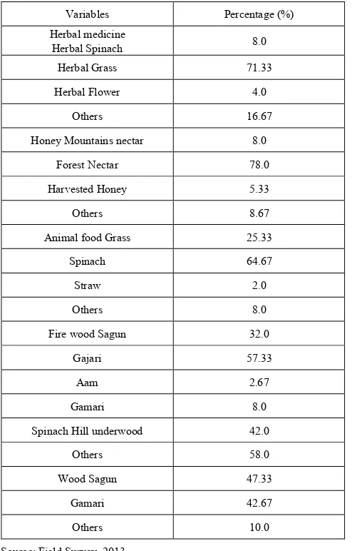
[image:3.595.61.296.120.422.2] [image:3.595.359.509.419.559.2] [image:3.595.99.261.588.717.2] [image:3.595.362.509.603.740.2]Many of the communities reported that the herbal medicine facility is enough for them. Over 71.33% of communities have to say that. 16.67% are commented excessive. At present it is enough but at past it was more enough (74%). The species verities are- nim, bashok, dhutra, thatkuni, herbal grass etc (Table 2). Over 78% of the household reported that there have enough honey species at present. They collect honey from the forest nectar, mountain nectar, and harvested honey. About 64.67% of the people in Bandarban Sadar Uapzila have to say that there have enough animal food species at present (Table 2). But at past this quantity is more enough. The salient animal food species are grass, spinach, straw, insects, fish etc.
Table 2. Ecological facilities of the study area
Variables Percentage (%)
Herbal medicine
Herbal Spinach 8.0
Herbal Grass 71.33
Herbal Flower 4.0
Others 16.67
Honey Mountains nectar 8.0
Forest Nectar 78.0
Harvested Honey 5.33
Others 8.67
Animal food Grass 25.33
Spinach 64.67
Straw 2.0
Others 8.0
Fire wood Sagun 32.0
Gajari 57.33
Aam 2.67
Gamari 8.0
Spinach Hill underwood 42.0
Others 58.0
Wood Sagun 47.33
Gamari 42.67
Others 10.0
Source: Field Survey, 2013
Many of the communities reported that the firewood facility is enough for them (Table 2). Over 57.33% of communities have to say that. 12% are commented excessive. At present it is enough but at past it was more enough. The species verities are- sagun, gajari, aam, dry spinach etc (Table 2). Many of the communities reported that the wood facility is enough for them. Over 47.33% of communities have to say that. At present it is enough but at past it was more enough. The species verities are- sagun, gajari, aam,
gamari. teek etc(Table 2).
5. Environmental Degradation Scenario
Bandarban Sadar Upazila is regularly flooded by flash floods from the Shangu and Karnafuli rivers. The affected areas remain waterlogged for a few days after every flood and thus sustain severe damage. The areas are often lashed by cyclones. Landslides are a common occurrence during the rnonsoon. People blamed increasing siltation of the rivers due to soil erosion, deforestation, faulty agricultural practices, etc., for the land- slides. Riverbank erosion results in substantial losses of people's farming and homestead lands, livelihoods and assets. Besides causing destruction of the physical infrastructure like roads, bridges and market centers, river erosion uproots people from their communities and social networks. The nature of Disaster in Bandarban Sadar Upazila is given below:6. Types of Natural Disaster
About 24.67% of the household said that the main disaster risk is land slide. And they are facing this frequently of several years. Other natural disasters are flood (44.67%), cyclone (18.67%), flash flood (10.66%) etc. Last 5 years they have to face flood at higher amount (44.67%), land slide 20.67% and flash flood 12.67%. So the disaster risk is increasing. People blamed increasing disaster risk due to hill cutting soil erosion, deforestation, faulty agricultural practices, etc., for the land- slides.
7. Findings
7.1. Major findings are
Peoples of this region are used ecological services very much.
Due to excess use of herbal spinach this species are declining at rapid rate.
Due to overconsumption of fresh water fish this species are now at endangered.
Due to rapid cutting of tree this area is ruin to open space. As a result deforestation takes place at significantly.
Ecological resources are declining at rapid rate
About 24.67% of the household said that the main disaster risk is land slide.
They are facing this frequently of several years. Other natural disasters are flood (44.67%), cyclone (18.67%), flash flood (10.66%) etc.
Last 5 years they have to face flood at higher amount (44.67%).
When land slide 20.67% and flash flood 12.67%.
[image:4.595.56.303.254.640.2]increasing disaster risk due to hill cutting soil erosion, deforestation, faulty agricultural practices, etc., for the land- slides.
8. Recommendations
To facilitate the alternatives use of ecological facilities.
To strengthens surveillance system to stop illicit felling of trees and housing which are causal link to the disaster.
To stimulate Disaster Management Committee organizing Meeting monthly.
To make awareness amongst the mass people.
To notify people about the weather forecasting.
To be aware of the loss due to disaster.
To give direction timely to move for safer place before the probable hazard.
To organize local enlightened people in disaster management.
9. Conclusions
The current study has been conceived for a comprehensive understanding of socio-economic status, agricultural condition, ecological condition and disaster management of the people living in Bandarban, which is one of the most disadvantaged and vulnerable regions in terms of various development indicators (income, employment, poverty, health and water, environment and sanitation (WES), education, inter community confidence, etc.). The study has been aimed at generating benchmark information for understanding periodic progress attained through interventions. Project document analyses, Field visit, Focus Group Discussion, Interview have done for gathering information to write the report.
Coping capabilities of community members, good background knowledge of the risk prone areas and identification of socially vulnerable groups are important components of disaster mitigation and preparedness measures. Thus, individuals and local community based networks are often deemed more suitable for initiating the first response when a disaster hits. Traditionally, people have adapted their means of livelihood with recurring hazards and have developed coping options based on local level knowledge systems. From the realization of this reality, the Government of Bangladesh as well as international organizations should undertake plans and programs for disaster reduction through disaster management in this area.
REFERENCES
[1] Asiatic Society of Bangladesh (2003). Banglapedia (the
National Encyclopedia of Bangladesh). Online. http://banglapedia.search.com.bd/
[2] Bangladesh District Gazetteers (1975) Chittagong Hill Tracts, Ministry of Cabinet Affairs, Establishment Division, Dacca. [3] .Bangladesh Peoples Democratic Movement (UK).
‘Bangladesh: Planned Ethnocide of Minority Nationalities In Chittagong Hill Tracts’. Online. 9 January 2008. http://www.radicalparty.org/humanrights/chit_do8.htm [4] BBS (2011a). Household Income and Expenditure Survey
2005, Dhaka: Bangladesh Bureau of Statistics (BBS), Planning Division, Ministry of Planning, Government of Peoples Republic of Bangladesh.
[5] BBS (2011b). Bangladesh Population Census 2001, National Series, Volume-2, Union Statistics, Bangladesh Bureau of Statistics (BBS), Planning Division, Ministry of Planning, Government of People’s Republic of Bangladesh.
[6] BBS (2011c). Bangladesh Population Census 2001, Community Series, Zila: Bandarban, Bangladesh Bureau of Statistics (BBS), Planning Division, Ministry of Planning, Government of People’s Republic of Bangladesh.
[7] BBS (2011). Statistical Pocketbook of Bangladesh 2005, Bangladesh Bureau of Statistics (BBS), Planning Division, Ministry of Planning, Government of People’s Republic of Bangladesh.
[8] BBS (2001). Bangladesh Population Census 1991, Volume-1, Analytical Report, Bangladesh Bureau of Statistics (BBS), Planning Division, Ministry of Planning, Government of People’s Republic of Bangladesh.
[9] Barkat, Abul et al. (2007c). “Assessment of Socio-Economic Improvement in the Life of Targeted People with special focus on Extreme poor, Women & Girls because of Water, Sanitation and Hygiene Intervention: An Impact Study”, conducted by Human Development Research Centre (HDRC) for WaterAid Bangladesh, Dhaka, Bangladesh.
[10] Barkat, Abul et al. (2007d). “Study on Mainstreaming Gender and Reaching Poor in Environmental Sanitation, Hygiene and Water Supply in Rural Areas (ESHWARA)”, conducted by Human Development Research Centre (HDRC) for Water & Environmental Sanitation Section, UNICEF, Bangladesh. [11] Barkat, Abul et al. (2002). “Economic and Social Impact
Evaluation Study of the Rural Electrification Program in Bangladesh”, conducted by Human Development Research Centre (HDRC) for NRECA International Ltd (partners with the REB & USAID for the Rural Power for Poverty Alleviation (RPPR) Program) Dhaka, Bangladesh.
[12] Barkat, Abul and Shamsul Huda (1988). “Politico-Economic Essence of Ethnic Conflicts in the Chittagong Hill Tracts of Bangladesh” in Social Science Review, Vol.-V, No-2, pp.103-127, December 1988: The Dhaka University Studies, Part-D.
[13] Government of the People’s Republic of Bangladesh >>Home >>Ministries: Divisions: Departments >>Ministry of Chittagong Hill Tracts Affairs >>Peace Accord. Online. 11 December 2007. http://www.mochta.gov.bd/client_peace_accord.php?id=2 (also 1 & 3).
[15] NIPORT (2007). Bangladesh Demographic and Health Survey 2007, Preliminary Report, National Institute of Population Research and Training (NIPORT), Dhaka, Bangladesh.
[16] Shelly, Mizanur Rahman, ed. (1992). The CHT of Bangladesh: The untold Story, Dhaka, Bangladesh: Centre for Development research (CDRB).
[17] World Health Organization (1987). ‘Concept of Health Behaviour Research’, SEARO Regional Health Papers No 13, Regional Office for South-East Asia (SEARO), New Delhi: 1987.