https://doi.org/10.5194/hess-22-4605-2018 © Author(s) 2018. This work is distributed under the Creative Commons Attribution 4.0 License.
Joint assimilation of soil moisture retrieved from multiple passive
microwave frequencies increases robustness of
soil moisture state estimation
Anouk I. Gevaert1, Luigi J. Renzullo2, Albert I. J. M. van Dijk2, Hans J. van der Woerd3, Albrecht H. Weerts4,5, and Richard A. M. de Jeu6
1Earth and Climate Cluster, Department of Earth Sciences, VU University Amsterdam, Amsterdam, the Netherlands 2Fenner School of Environment and Society, Australia National University, Canberra, Australia
3Institute for Environmental Studies (IVM), VU University Amsterdam, Amsterdam, the Netherlands 4Deltares, Delft, the Netherlands
5Department of Environmental Sciences, Wageningen University, Wageningen, the Netherlands 6VanderSat B.V., Haarlem, the Netherlands
Correspondence:Anouk I. Gevaert ([email protected]) Received: 31 December 2017 – Discussion started: 4 April 2018
Revised: 4 July 2018 – Accepted: 14 July 2018 – Published: 3 September 2018
Abstract.Soil moisture affects the partitioning of water and energy and is recognized as an essential climate variable. Soil moisture estimates derived from passive microwave remote sensing can improve model estimates through data assimi-lation, but the relative effectiveness of microwave retrievals in different frequencies is unclear. Land Parameter Retrieval Model (LPRM) satellite soil moisture derived from L-, C-, and X-band frequency remote sensing were assimilated in the Australian Water Resources Assessment landscape hydrol-ogy model (AWRA-L) using an ensemble Kalman filter ap-proach. Two sets of experiments were performed. First, each retrieval was assimilated individually for comparison. Sec-ond, each possible combination of two retrievals was assim-ilated jointly. Results were evaluated against field-measured top-layer and root-zone soil moisture at 24 sites across Aus-tralia. Assimilation generally improved the coefficient of cor-relation (r) between modeled and field-measured soil mois-ture. L- and X-band retrievals were more informative than C-band retrievals, improving r by an average of 0.11 and 0.08 compared to 0.04, respectively. Although L-band re-trievals were more informative for top-layer soil moisture in most cases, there were exceptions, and L- and X-band were equally informative for root-zone soil moisture. The consis-tency between L- and X-band retrievals suggests that they can substitute for each other, for example when transitioning between sensors and missions. Furthermore, joint
assimila-tion of retrievals resulted in a model performance that was similar to or better than assimilating either retrieval individ-ually. Comparison of model estimates obtained with global precipitation data and with higher-quality, higher-resolution regional data, respectively, demonstrated that precipitation data quality does determine the overall benefit that can be expected from assimilation. Further work is needed to assess the potentially complementary spatial information that can be derived from retrievals from different frequencies.
1 Introduction
surface and root-zone soil moisture (Renzullo et al., 2014; Draper et al., 2012; Reichle and Koster, 2005), evaporation (Tian et al., 2017), and runoff (Brocca et al., 2010; López López et al., 2016).
A variety of observation-based soil moisture estimates have been used in data assimilation, including field- (Aubert et al., 2003; Lee et al., 2011), airborne- (Margulis et al., 2002), and space-borne (e.g. Reichle et al., 2007; Pauwels et al., 2001) measurements. Soil moisture datasets based on microwave remote sensing are of particular interest because of their global coverage, near-daily resolution and low sensi-tivity to atmospheric interferences. Several studies have as-similated satellite soil moisture retrievals derived from active (e.g. Pauwels et al., 2001; Brocca et al., 2011; Draper et al., 2011) and passive (e.g. Reichle et al., 2007; Q. Liu et al., 2011; Gao et al., 2007; López López et al., 2016) microwave sensors, as well as a combination of passive and active sen-sors (Draper et al., 2012; Renzullo et al., 2014).
Aside from the distinction between active and passive mi-crowave sensors, soil moisture retrievals can be retrieved from different frequencies. Common frequencies are L band (1.4 GHz), C band (6 GHz), and X band (10 GHz). Of these, L band is often assumed to be optimal for soil moisture re-trieval because it is less sensitive to vegetation cover and the atmosphere than the higher frequency retrievals, as well as having a deeper signal depth (e.g. Schmugge, 1978; Ulaby et al., 1986). At the same time, the lower emission intensity means that the observation footprint increases with decreas-ing frequency, creatdecreas-ing a trade-off between spatial detail on the one hand, and observation depth and interference from vegetation and the atmosphere on the other. Studies evaluat-ing and comparevaluat-ing satellite soil moisture retrievals have em-pirically confirmed that errors in soil moisture retrievals tend to increase with increasing frequency (Dorigo et al., 2010). Also, L-band retrievals tend to outperform C-band retrievals over the more moderate vegetated regions (e.g. Holgate et al., 2016; Al-Yaari et al., 2014; van der Schalie et al., 2016). It may be expected that this higher accuracy leads to higher benefits of data assimilation, but this is yet to be demon-strated.
Ultimately, the benefit of assimilation depends on the rel-ative magnitude of errors in the retrievals and in the model. Holgate et al. (2016) and Renzullo et al. (2016) found that model estimates of soil moisture already had better accuracy than those from remote sensing for some Australian sites, in which case there may be little benefit from assimilation. However, this may have been a function of the high-quality precipitation estimates due to a relatively dense station mea-surement network. Precipitation estimates can be expected to be of considerably lower quality for many parts of the world, and there is a need to understand whether satellite data assim-ilation may be more beneficial under those circumstances.
Here, we assimilate passive microwave retrievals derived from three different frequencies, but using a common radia-tive transfer model. Our main objecradia-tive is to understand
dif-ferences between the retrievals in terms of their performance in data assimilation experiments and to investigate whether there is added value in their joint assimilation. In addition, we evaluate to what extent the benefit of assimilation depends on the quality of precipitation estimates used in modeling.
2 Soil moisture data 2.1 Satellite data
Soil moisture data were derived from brightness temper-atures from two space-borne sensors. The Advanced Mi-crowave Scanning Radiometer 2 (AMSR-2) provides data for the C- (6.9 GHz) and X-band (10.65 GHz) frequencies. These data have spatial resolutions of approximately 50 (C band) and 38 km (X band), respectively, and are sensitive to the top 1–2 cm soil layer (Owe et al., 2008). The Soil Moisture Ocean Salinity (SMOS) provides L-band (1.4 GHz) bright-ness temperatures. These observations have a spatial resolu-tion of 43 km and are expected to be sensitive to the upper-most 5 cm of the soil. We focus on retrievals based on the nighttime overpasses (i.e., descending for AMSR-2, ascend-ing for SMOS) because at night the assumption of equal veg-etation and surface temperature is better met (de Jeu, 2003; Y. Y. Liu et al., 2011). It has also been shown empirically to produce better results (Holgate et al., 2016). Soil mois-ture data were derived from the C-, L-, and X-band bright-ness temperatures using the Land Parameter Retrieval Model (LPRM, Owe et al., 2008) v6 with the parameterizations described in Parinussa et al. (2015) and van der Schalie et al. (2016). Despite the common retrieval models, the param-eterizations vary with the frequency of the brightness temper-atures. Lastly, all three datasets were resampled to a regular 0.25◦grid.
2.2 Field-measured data
of sites in Table S1 in the Supplement). The sensor measure-ments were converted to root-zone values based on weighted averages of the observed values, where weights correspond to the portion of the 90 cm root-zone layer closest to each sensor. Six OzFlux sites were excluded from the root-zone analysis because they had no sensors below 50 cm depth.
3 Methods
3.1 Hydrological model
The landscape hydrology component of the Australian Wa-ter Resources Assessment system (AWRA-L) simulates the dynamics of hydrological states and fluxes at a continental scale (van Dijk, 2010) and is the model underpinning Aus-tralia’s water resources assessments and accounts (Hafeez et al., 2015). The grid-based model has a 0.05◦resolution and is run at a daily time step. It is important to note that each grid cell is modeled independently, meaning that there is no lateral exchange of water between neighboring cells.
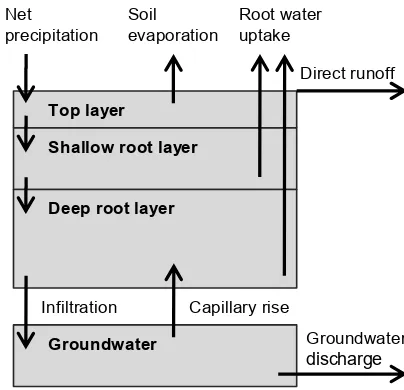
AWRA-L consists of three soil layers that, in contrast to most land surface models, do not have a predefined depth (Fig. 2). Instead, each soil layer has a prescribed maximum water storage capacity. Soil wetness outputs are water stor-ages relative to the available soil water, or the difference be-tween wilting point and field capacity, and therefore range from 0 to 1. The water storage can be converted to volu-metric water content when combined with soil texture data (Renzullo et al., 2014). Precipitation, reduced by intercep-tion and direct runoff, enters the soil column by the first soil layer. This top layer generally corresponds to a thickness of 5–10 cm and is also where soil evaporation occurs. The sec-ond layer is the shallow root layer and has a thickness of 10–20 cm. Conceptually, this layer is where shallow-rooted vegetation withdraws water for transpiration. The third soil layer, or deep root layer, has a thickness of 6–8 m and is ac-cessed by deep-rooted vegetation only. Finally, there is an underlying groundwater store which can transfer water to the deep root layer by means of capillary rise. Runoff from the grid cell consists of the direct runoff from the surface and drainage from the groundwater store. The runoff can be used as an input for a routing model to calculate river discharge, but this is part of another AWRA model system component (Hafeez et al., 2015).
AWRA-L was run at a point scale, at locations where field-measured soil moisture data were available. The model was forced with radiation, daily minimum, and maximum tem-perature from Australian Gridded Climate Data (AGCD) pro-vided by the Bureau of Meteorology (Jones et al., 2009). These data have a 0.05◦resolution. Two datasets with differ-ent spatial resolutions and quality were used to prescribe pre-cipitation on a daily basis. Tropical Rainfall Measuring Mis-sion (TRMM) 3B42 Real Time (GES DISC, 2016) daily pre-cipitation data with a 0.25◦resolution were used for the main
experiments. In an additional analysis, we use the model forced with higher-resolution gridded AGCD precipitation dataset as a benchmark. In this way, we assess whether pre-cipitation data quality affects the potential for data assimila-tion to improve model performance. The assimilaassimila-tion experi-ments cover the period from July 2012 until April 2015, with model simulations starting in January 2005 to avoid errors in the initial conditions. The model version and parameteri-zation (v0.5; van Dijk, 2010) have not been calibrated with either satellite or field-measured soil moisture data.
3.2 Data pre-processing
Satellite soil moisture data were prepared for assimilation in several steps. First, satellite data were assigned to the model pixels using a nearest-neighbor approach. Next, the data were scaled to the model range to reduce bias. Previous studies have used a variety of methods for bias correction, such as linear rescaling between the minimum and maximum values (Brocca et al., 2011) or between model wilting point and field capacity (López López et al., 2016), first and second mo-ment matching (Draper et al., 2009; Brocca et al., 2010), and cumulative density function matching (Reichle and Koster, 2004; Draper et al., 2012). Each approach has its strengths and weaknesses. In this study, we apply a linear rescaling method matching the 5th and 95th percentiles of the observed dataset to the model data. We chose this approach because it retains the temporal distribution and scales it to the model dynamic range in a manner that avoids undue influence from outliers.
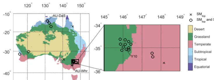
Figure 1.Field-measured soil moisture stations from the OzNet and OzFlux networks plotted against the major Köppen–Geiger climate zones. Stations indicated by crosses provide top-layer soil moisture data individually; sites indicated by a circle also provide root-zone data.
In the joint assimilation experiments, we need to account for the difference in observation frequency of the SMOS and AMSR-2 soil moisture retrievals. On average, SMOS retrievals are available on 40 % of the days in the assim-ilation period, compared to nearly 75 % for AMSR-2 re-trievals. Instead of subjectively adjusting the error estimates or weighting factors, we aggregated the time series with a higher observation frequency to the measurement intervals of the time series with fewer observations. In other words, for each day with a measurement in the SMOS time series, we averaged all observations in the AMSR-2 time series that occurred between the previous SMOS observation and the current observation. We limited the aggregation period to a maximum of 7 days and assigned equal weights to all obser-vations falling within the aggregation period. Alternatively, more recent observations could be given more weight, but as there are usually only one or two AMSR-2 observations between SMOS observations, we consider a simple average to be suitable. The errors assigned to the resulting concur-rent observation time series were recalculated using the triple collocation method to use as weights in the joint assimilation experiments.
3.3 Assimilation procedure
Soil moisture data were assimilated using an ensemble Kalman filter (EnKF) approach. This is a relatively simple and common method for assimilating observations into a va-riety of models (e.g. Draper et al., 2012; Reichle et al., 2002; Renzullo et al., 2014; López López et al., 2016) and consists of two steps. In the forecast step, ensembles are generated by perturbing the meteorological forcing data and propagating the model to the next time step. The ensembles are used to characterize the model error variances. In the analysis time step, the model states are adjusted towards the observations.
The analysis time step is calculated as
xta=xtf+Kt[yt−Ht(xft)], (1)
wherextf is the model forecast, xta the model analysis,Kt the Kalman gain,yt the observation, andHt the observation model, which relates the model state to the observations, all at timet. The Kalman gain expresses the relative weighting of the observations with respect to the model and is defined as
Kt =PtHTt (Rt+HtPtHTt )
−1, (2)
whereRt is the observation error variance for a certain loca-tion,HtPtHtT is the model error variance matrix, andPtHtT is the covariance matrix between the model states and model observations. Observational error is site-specific, but fixed in time. Model error variance is based on ensemble spread and varies over space and time (see below). If the model error is much lower than the observation error,Kt will approach zero and the observation will not impact the model analysis. Alternatively, if the observation error is much lower than the model error variance, the model analysis will be dominated by the observation. This assimilation updating procedure was applied to the first two soil layers of the AWRA-L model: the top layer and the shallow root layer.
Top layer
Shallow root layer
Deep root layer Net
precipitation Soil evaporation
Root water uptake
Groundwater
Capillary rise Infiltration
Direct runoff
[image:5.612.64.266.68.263.2]Groundwater discharge
Figure 2.Schematization of the structure of AWRA-L showing the three soil layers, groundwater store, and the relevant hydrological fluxes. Net precipitation refers to the precipitation reduced by inter-ception.
were adjusted to zero and the maximum value, respectively. This adjustment is necessary for the physical realism of the model, but may introduce bias. However, since the inflation factor is only used to ensure a model error of 2 %, the bias should be small even when the ensemble members approach the boundaries.
A total of 100 ensembles were generated by perturbing the rainfall, radiation, and temperature data in following Ren-zullo et al. (2014). Precipitation errors were multiplicative and drawn from a uniform distribution ranging ±60 % of (i.e. 0.4–1.6 times) the forcing value. This error was based on spatial error estimates for the AGCD precipitation dataset (Jones et al., 2009), but was also applied to the TRMM precipitation data. Radiation and temperature perturbations were additive, with assumed standard deviations of 2 K and 50 W m−2, respectively. A correlation structure was enforced to minimize unlikely combinations of the radiation, temper-ature, and rainfall perturbations (in that order), specified by Renzullo et al. (2014):
C=
1 0.7 −0.8 0.7 1 −0.5
−0.8 −0.5 1
. (3)
The observations were perturbed according to a Gaussian distribution with the triple collocation error estimates as stan-dard deviations. Similar to the variable inflation factor, per-turbing soil moisture observations near the boundaries of the variables may result in values that are not physically real. The values falling outside the boundaries are therefore adjusted to the nearest limit. However, this process may introduce bias,
especially where soil moisture observations are near its upper and lower boundaries.
3.4 Model evaluation
Model performance was based on the agreement between model soil moisture and field-measured data. Specifically, we based model performance on Pearson’srbetween the model ensemble mean and daily averages of the field-measured time series during the assimilation period. The impact of data as-similation on model performance is defined as the difference betweenrfor the open loop and data assimilation scenarios, 1r. Other methods of evaluation, such as root mean square error and bias, were not included because AWRA-L simu-lates water storage in the soil layers rather than volumetric water content. The correlations were calculated using the ac-tual time series as well as anomaly values, i.e. the deviations from the climatology. The climatology was calculated as the average of all days in the assimilation period (June 2012 to April 2015) falling within a 31-day window centered on a given day of the year. Correlations based on actual values re-flect the ability of the modeled time series to capture the sea-sonal pattern of soil moisture, whiler for anomalies reflect the ability to capture deviations from the seasonal pattern. Significance levels of1r are based on the Steiger test for dependent correlations (Steiger, 1980), using a significance level ofp <0.05.
The strong differences in the spatial representativeness is a complicating factor in the evaluation; for field measurements it is on the order of centimeters, the model has a grid res-olution of approximately 5 km, and the satellite data have a footprint of tens of kilometers diameter. Nevertheless, higher agreement with field-measured soil moisture increases confi-dence in model and satellite soil moisture estimates.
3.5 Experimental setup
Our main goal is to assess and compare the ability for soil moisture retrievals based on multiple passive microwave fre-quencies to improve the performance of the AWRA-L model. For reference, we compare model and satellite-based soil moisture to field-measured data as an indicator of the relative performance of the retrievals and of the potential for data as-similation to improve model estimates. Then, we address the main goal through three sets of experiments.
soil moisture content, respectively, based on the open-loop model simulation for each site. The transitional periods con-sist of the remaining months. The results of this experiment are used to evaluate and compare the ability of each of the retrievals to improve model performance.
Second, we assimilated each set of two soil moisture datasets (i.e. L-band and band, L-band and X-band, C-band and X-C-band retrievals) jointly. In this experiment, the impact of assimilation was again assessed based onr. How-ever, the performance of the single-retrieval assimilation ex-periments was used as a reference rather than the open-loop simulation. In this way, we evaluate the added value of joint assimilation with respect to assimilating the retrievals indi-vidually.
Third, we repeated the single and joint assimilation exper-iments forcing the model with resolution and higher-quality AGCD precipitation instead of TRMM precipita-tion. This experiment aimed to assess whether the quality of the precipitation data affects the impact of data assim-ilation on model performance. By using the real-time ver-sion of TRMM, which is not gauge-corrected, we can as-sess the added value of soil moisture assimilation in regions where there are fewer rain gauges and precipitation data qual-ity is therefore relatively poor. For reference, we compared open-loop model performance using the two precipitation datasets as an indicator of the difference in precipitation qual-ity. Then, we compared the impact of data assimilation for the two datasets, based on the change in model performance after data assimilation (1r).
All three experiments were designed from an empirical rather than theoretical point of view. We compare the ef-fect of assimilating soil moisture retrievals based on multiple microwave frequencies, but additional factors would need to be taken into account to truly isolate the effect of frequency. First, despite the common retrieval model, parameterization of the model such as surface roughness and single scattering albedo differ. In addition, AMSR-2 retrievals use simultane-ously retrieved passive microwave observations to derive the soil temperature, while SMOS retrievals use model tempera-ture (van der Schalie et al., 2016). Second, we did not correct for differences in the characteristics of the sensors and plat-forms, such as viewing angle, overpass time, and observation depth. Third, the error characteristics of the soil moisture re-trievals used to determine the weights of the observations in the assimilation scheme were allowed to vary between re-trievals. This choice was deliberate, as applying a single er-ror value to all retrievals may create a mismatch between the assigned error value and the quality of the observations. As a result, the difference in assimilation results reflects many characteristics of the retrievals and not only the frequency itself.
4 Results
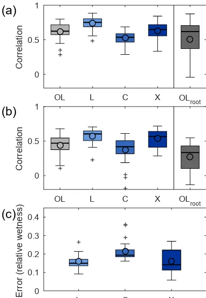
We first assessed the potential for satellite soil moisture as-similation to improve the model based on a comparison against field observations. The model skill is variable, with rbetween field-measured and top-layer soil moisture as high as 0.8 and as low as 0.3. The skill of the model is gener-ally higher for actual values (Fig. 3a) than for anomalies (Fig. 3b). At most sites, L-band retrievals have the highest agreement with field-measured data, followed by the X- and C-band retrievals, respectively (Fig. 3a). For anomaly time series, however, L- and X-band retrievals perform similarly well (Fig. 3b). The results of the triple collocation analysis independently confirm these patterns, with lower errors for L- and X-band soil moisture and higher errors for C-band soil moisture (Fig. 3c).
4.1 Evaluation against soil moisture
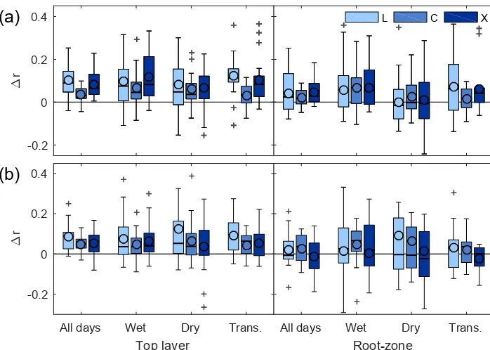
Data assimilation generally improved the agreement between modeled and field-measured top-layer soil moisture, increas-ing r by up to 0.3 compared to the open-loop scenario (Fig. 4a). Based on Steiger tests (see Sect. 3.4), the improve-ments in model performance are statistically significant at 75–90 % of the sites, depending on the assimilated retrieval. Assimilating L-band soil moisture has the largest impact overall (average1r is 0.11), followed by the X-band (0.08) and C-band (0.04) retrievals, respectively. On a site-by-site basis, however, L-band soil moisture is not always the most informative. At 5 out of 24 sites (21 %), X-band retrievals are the most informative, and at 1 site C-band retrievals are the most informative (see Table S1). Modeled root-zone soil moisture also tends to improve after data assimilation, though model performance degrades slightly at about a quarter of the sites. The L-band and X-band retrievals have comparable re-sults overall, though there is a slight advantage for L-band soil moisture on a site-by-site basis (most informative at 11 out of 24 sites, compared to 9 for X-band). Based on Steiger tests, about 90 % of the differences inrbetween these assim-ilation experiments are statistically significant.
OL L C X OLroot 0
0.5 1
Correlation
(a)
OL L C X OLroot
0 0.5 1
Correlation
(b)
L C X
0 0.1 0.2 0.3 0.4
Error (relative wetness)
[image:7.612.63.272.70.372.2](c)
Figure 3. Evaluation of top-layer open-loop model soil mois-ture (OL) and satellite soil moismois-ture observations against field measurements based on correlations (r) between July 2012 and April 2015(a)and the same using anomaly time series(b). Cor-relations (r) between root-zone open-loop model and root-zone field measurements are also shown. The triple collocation errors for the satellite soil moisture retrievals in AWRA-L wetness units are shown in(c). Box plots show the inter-quartile range (box), outliers (+), the median (thick line), and the mean (o). Outliers are based on points at a distance larger than 1.5 times the inter-quartile range from the first and third quartiles.
on root-zone soil moisture is larger than for top-layer soil moisture. On average, data assimilation is informative in the wet season, while there is no change in model performance after assimilation in the dry season. However, the variability between sites is considerable.
The effect of assimilation is also evaluated for anomaly time series, which reflects the model performance at subsea-sonal timescales. Similarly to the analysis based on actual time series, data assimilation tends to improve model perfor-mance against field-measured data (Fig. 4b). However, the magnitude of the changes is somewhat smaller and degra-dations in the agreement between model and field-measured root-zone soil moisture can be more substantial. For top-layer soil moisture, assimilating L-band retrievals leads to higher model performance than the other two datasets
over-all, and it is also the most informative at 13 out of 24 sites (54 %). In contrast to the evaluation of actual values, the C-band retrievals are the most informative at more sites than X-band retrievals (at 8 compared to 3 out of 24 sites, respec-tively). On average, however, the changes in correlation are similar for both datasets (Fig. 4b). For root-zone soil mois-ture, the effectiveness of assimilation is similar between ex-periments. In contrast to the results for actual values, assim-ilation tends to be most effective for anomaly time series in the dry season instead of the wet season, especially for root-zone soil moisture. Assimilation during transitional periods between the wet and dry seasons is informative for the top layer, but not for the root zone.
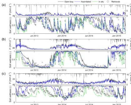
Time series plots of modeled top-layer soil moisture at three sites (see Fig. 1 for their locations) illustrate the con-trasting effect of assimilation in the wet and dry seasons. In wetter months, the model tends to overestimate soil moisture in the open-loop scenario (Fig. 5). Data assimilation results in lower soil moisture content in this period, more closely matching the field-measured data. This is particularly true for the end of the wet season, as the transitional period be-tween wet and dry seasons starts sooner in the field-measured data than in the open-loop data. Periods where data assimi-lation leads to lower soil wetness also show lower evapora-tion rates. In drier months, however, the open-loop simula-tion more closely matches the field-measured data, leaving little opportunity to improve the model. Sites where there is little to no rainfall in the dry season are particularly affected, as the assimilation tends to add noise to the otherwise smooth recession curves, as displayed by AU-Whr in Fig. 5. Further-more, the time series show that the model error variance is reduced through the data assimilation.
It is noted that there is a considerable difference in the number of observations in the soil moisture retrievals, with more observations in the C- and X-band datasets (662–830 observations in 3 years) than in the L-band dataset (225– 500 observations). This difference in the number of observa-tions could affect the impact of data assimilation, especially when evaluating the anomaly time series. However, correct-ing for the number and timcorrect-ing of observations by assimilat-ing the concurrent retrievals also used in joint assimilation has a limited effect on results. The relative impact of the soil moisture retrievals is unchanged, though model improvement after data assimilation is slightly lower. The lower impact of data assimilation is most likely because satellite observa-tions, and thus model updates, are more infrequent. Fewer updates can result in a lower impact of data assimilation over a particular study period.
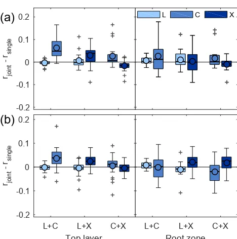
4.2 Added value of joint assimilation
-0.2 0 0.2 0.4
∆
r
(a)
All days Wet Dry Trans.
Top layer -0.2
0 0.2 0.4
∆
r
(b)
L C X
All days Wet Dry Trans.
[image:8.612.127.476.67.316.2]Root-zone
Figure 4.The change in correlation (1r) between modeled and field-measured top-layer (N=24) and root-zone (N=19) soil moisture (July 2012 to April 2015) after soil moisture assimilation, where1ris calculated over the entire time period, the wet season, the dry season, and transitional periods(a). In(b), the same is shown for anomaly time series. Box plots are defined as in Fig. 3.
superior to assimilating C-band (or X-band) retrievals indi-vidually, but performed similarly to assimilating L-band re-trievals individually (Fig. 6a). On average, joint assimilation improved model performance compared to assimilating C-band (or X-C-band) individually by 0.07 (0.03), but on aver-age, the difference between joint assimilation and assimilat-ing L-band retrievals individually was 0.00. Joint assimila-tion of C- and X-band retrievals improved performance com-pared to assimilating C-band retrievals individually, but over-all slightly degraded model performance compared to assim-ilating X band individually. As a result, the sets including L-band retrievals as one of the two assimilated datasets outper-form the joint assimilation of C-band and X-band retrievals. The difference between the combinations including L-band retrievals and the C- and X-band combination is statistically significant at nearly 90 % of the sites. When considering root-zone soil moisture, the main difference was that the added value of joint assimilation of L- and C-band (or X-band) re-trievals was smaller when compared to assimilating C-band (or X-band) retrievals individually.
Joint assimilation shows similar results when evaluating the anomaly time series. Again, joint assimilation of L-band soil moisture along with another dataset improved model per-formance compared to assimilating C- or X-band individu-ally, but was not significantly different from assimilating L-band soil moisture individually (Fig. 6b). The joint assimi-lation of C- and X-band retrievals further improved model agreement with field-measured data at nearly half of the sites,
but the difference between joint assimilation and single as-similation of either dataset for this set is not statistically sig-nificant.
Figure 5.Time series of precipitation forcing and modeled evaporation and top-layer model soil moisture in the open loop (grey line and shading) and after assimilating L-band retrievals (blue line and shading) at sites Y10(a), AU-Whr(b), and AU-DaS(c). Time series of rescaled L-band retrievals (circles) and field–measured soil moisture (green line) are included for reference. These sites are classified as a grassland, savanna, and evergreen broadleaf forest, respectively. Shaded areas represent the 10th–90th percentiles of the model ensemble.
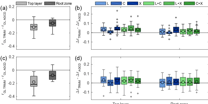
4.3 Influence of precipitation data quality
We repeated the assimilation experiments using a higher-resolution and better-quality precipitation dataset to evaluate the importance of the quality of the prior model estimates. At all but three sites, forcing AWRA-L with AGCD precipita-tion leads to better open-loop model performance than when TRMM precipitation is used (Fig. 7a). Therbetween model and field-measured soil moisture differs by up to 0.3. The three sites where AGCD precipitation leads to lower model performance are located in northern Australia, where the density of precipitation gauges used to create the AGCD pre-cipitation dataset is relatively low. The largest improvements in model performance when using AGCD instead of TRMM precipitation are found in southeastern Australia, where the gauge density is relatively high.
The impact of data assimilation was generally higher when the model was forced with lower-quality TRMM precipita-tion data. In other words, the change in model performance after data assimilation (1r) was larger for the TRMM
ex-periments than for the AGCD exex-periments (Fig. 7b). The difference was relatively large for X- and L-band retrievals, and relatively small when assimilating C-band retrievals. On average, data assimilation improved correlations with field-measured by 0.01–0.05 more when the model was forced with TRMM precipitation than when forced with AGCD pre-cipitation, depending on which retrievals were assimilated (0.01–0.04 for root-zone data). Despite the fact that data as-similation is less informative when AGCD precipitation is used, it generally still has a positive impact on model perfor-mance. Correlations between model and field-measured soil moisture increased by an average of 0.02–0.07 for top-layer soil moisture and 0.01–0.04 for top-layer soil moisture, de-pending on the assimilated retrieval(s).
-0.2 -0.1 0 0.1 0.2
r joint
- r
single
(a)
L+C L+X C+X
Top layer -0.2
-0.1 0 0.1 0.2
r joint
- r
single
(b)
L C X
L+C L+X C+X
[image:10.612.53.287.64.300.2]Root zone
Figure 6.The difference in model performance between the joint assimilation and single-retrieval assimilation for surface (N=24) and root-zone (N=19) soil moisture (a), where model perfor-mance is based on the correlation (r) between modeled and field-measured soil moisture (July 2012 to April 2015). The legend in-dicates which single-assimilation experiment is used as a reference to evaluate the joint assimilation experiments. In (b), the same is shown for anomaly time series. Box plots are defined as in Fig. 3.
the variability in the difference in the impact of data assimi-lation was higher for anomaly time series.
If we use the difference in open-loop model performance as a proxy for precipitation quality, we can quantify the re-lationship between the difference in precipitation quality of the TRMM and AGCD datasets (i.e. data in Fig. 7a and c) and the corresponding difference in the impact of data as-similation (i.e. data in Fig. 7b and d). Pearson’s r between precipitation data quality and impact of data assimilation experiments vary between −0.83 and −0.57 for top-layer soil moisture, except when assimilating C-band retrievals in-dividually (r= −0.22). The relationship for root-zone soil moisture is slightly weaker, withrbetween−0.79 and−0.32 (except r = −0.16 for C band). This means that, on the one hand, where using AGCD and TRMM precipitation re-sulted in similar model performance, the impact of data as-similation on model performance was also similar. Where using AGCD precipitation resulted in higher model perfor-mance than TRMM, on the other hand, data assimilation had a smaller impact than when TRMM precipitation was used.
5 Discussion
We approached this study of the impact of assimilating satel-lite soil moisture retrievals based on different microwave frequencies from an empirical perspective. As discussed in Sect. 3.5, differences in the results of the assimilation exper-iments are affected not only by frequency, but also by differ-ences in the characteristics of the sensors and platforms, in the parameterization of the common retrieval model, and in the error characteristics of the retrievals. A more theoretical approach is needed to untangle these confounding factors.
Another important choice in the experimental setup was the rescaling technique. We chose a relatively simple lin-ear rescaling technique to transform satellite observations to model space. Previous studies have suggested that more so-phisticated bias correction techniques are more suitable (i.e. Yilmaz and Crow, 2013), but these techniques usually as-sume that there is no consistent bias between the model and observations. Here, we found that the model was clearly bi-ased in the wet season, especially for AU-DaS (Fig. 5). In those conditions, observations have considerable potential to improve model results, and that potential would be di-minished by forcing the observations to match the incorrect model dynamics.
Overall, L-band soil moisture retrievals showed the best agreement with field-measured data over the study sites (Fig. 3), which is consistent with previous studies (Al-Yaari et al., 2014; Holgate et al., 2016). Interestingly, errors did not increase with increasing frequency, and the X-band re-trievals performed better than C-band rere-trievals. This may be typical of the sites studied here or of the AMSR-2 sen-sor, as previous studies have found that LPRM C-band re-trievals from AMSR-2’s predecessor, AMSR-E, slightly out-perform X-band retrievals (Gruhier et al., 2010; Parinussa et al., 2011). As expected, datasets with smaller errors were generally more informative in assimilation, especially for top-layer soil moisture. This can be attributed in part to the differences in the magnitude of the errors, as this affects the weight given to the observations in the assimilation proce-dure. On average, triple collocation errors for C-band re-trievals were 0.24 (AWRA-L wetness units), compared to 0.18 for the other retrievals. Further research is needed to evaluate whether these differences in errors are due to the trade-off between spatial resolution and sensitivity to vege-tation and/or the atmosphere or whether they are the result of other factors. For the root zone, differences between the assimilation experiments are much less pronounced (Fig. 4). The similar information content in L- and X-band retrievals, especially, implies that data assimilation systems can substi-tute one retrieval for the other without substantially affecting model performance. This is especially important for model-ing systems that cover a relatively long time period that need to transition between microwave sensors and missions.
-0.1 0 0.1 0.2
∆
rTRMM
-
∆
rAGCD
(b) L C X L+C L+X C+X
Top layer Root zone
-0.1 0 0.1 0.2
∆
rTRMM
-
∆
rAGCD (d) -0.4
-0.2 0 0.2
rOL TRMM
- r
OL AGCD
(a)
-0.4 -0.2 0 0.2
rOL TRMM
- r
OL AGCD
(c)
[image:11.612.125.475.69.244.2]Top layer Root zone
Figure 7.The difference in open-loop model performance based onr(a)and the difference between the impact of data assimilation based on1r(b)between experiments using TRMM and AGCD precipitation data. Panels(c)and(d)show the same for anomaly time series. Box plots are defined as in Fig. 3.
similar to assimilating the more informative of the two re-trievals individually, and improved model performance com-pared to assimilating the less informative retrieval alone (by 0.02–0.07 on average, Fig. 6 and Sect. 4.3). Therefore, joint assimilation appears especially useful to take advantage of the superior information in whichever retrieval is the most informative in a particular location, without substantially de-grading model performance by the retrievals that are less informative. This means that joint assimilation is of added value when no single retrieval is the most informative in the study area, as was the case in this study. However, joint as-similation may not be of added value in studies where one soil moisture retrieval is the most informative. Based on the results of this study, combining L-band retrievals (SMOS) with either the C- or X-band retrievals (AMSR-2) is the most informative. However, the joint assimilation of C- and X-band retrievals performs surprisingly well considering the fact that errors between these retrievals, derived from the same AMSR-2 sensor, might not be expected to be fully in-dependent. Theoretically, this would compound errors in data assimilation, and degrade performance, but this was not usu-ally observed. Since we corrected for the number and timing of observations, this added value of joint assimilation can be attributed to other factors, which may include error character-istics, and characteristics of the sensors and microwave fre-quencies such as observation depth, spatial resolution, and viewing angle.
Though we are not aware of other studies jointly assimi-lating passive soil moisture retrievals, our results are in line with studies jointly assimilating active and passive soil mois-ture retrievals. Two studies, in particular, also use Australian study sites to evaluate the impact of (joint) soil moisture as-similation into land surface models. Draper et al. (2012) eval-uated soil moisture assimilation at sites in the United States
and southeastern Australia, while Renzullo et al. (2014) fo-cused on sites spread around Australia as in this study. The active and passive soil moisture retrievals were based on C-bane microwave data in both studies and therefore focus on complementary information in retrieval method, while in this study we focus on added value between microwave frequen-cies. Nevertheless, the conclusion of Draper et al. (2012) is very similar to that of this study, namely that joint assimila-tion leads to similar or better model performance than assim-ilating either retrieval individually. In contrast, Renzullo et al. (2014) stated that joint assimilation resulted in a compro-mise between the two retrievals. However, where reported, the correlations of the joint assimilation experiments were at most 0.02 lower than when assimilating the more informative soil moisture product individually in that study (Renzullo et al., 2014), suggesting that model performance is in fact sim-ilar.
precipitation data quality was relatively poor (Massari et al., 2018).
This study only examined the temporal aspect of differ-ences and complementary information between the different datasets. The model was run for each site independently and did not consider spatial covariance. It is conceivable that in-cluding this spatial dimension could change the results, for example improving the added value of joint assimilation. The complementary spatial information in passive microwave re-trievals could stem from the differences in the native foot-print sizes of the different microwave frequencies, or from using sharpened soil moisture retrievals (i.e. Merlin et al., 2013; Piles et al., 2011; Kim and Hogue, 2012; Gevaert et al., 2015). The spatial information could improve the spatial patterns of soil moisture in models, which could propagate into improved simulations of runoff and streamflow.
6 Summary and conclusions
Passive microwave soil moisture retrievals based on differ-ent frequencies but derived by a common retrieval algorithm were assimilated into the AWRA-L model. Model results were evaluated against field-measured soil moisture at 24 sites spread over the Australian continent to compare the ability. This evaluation compares the ability of the datasets to improve model soil moisture through data assimilation and assesses whether there is added value in joint assimilation. The study sites cover a range of climate and land cover types, but the evaluation is complicated by the differences in the representative area of the model and field-measured data.
Data assimilation generally has a positive impact on the performance of model top-layer and root-zone soil moisture, increasing rwith field-measured data by up to 0.3. Assimi-lation improves model performance more in the wet season, when the model skill is relatively low, than in the dry sea-son, when the model skill is relatively high. When anomaly time series are evaluated instead of the actual values, how-ever, assimilation is more informative in the dry season. The impact of data assimilation is also higher when the model is forced with global precipitation data than when it is forced with higher-quality, higher-resolution precipitation data.
Overall, assimilating L- and X-band retrievals had a more positive impact on model performance than assimilating C-band retrievals. L-C-band retrievals are slightly more informa-tive than X-band retrievals when evaluating top-layer soil moisture, but these differences are not statistically significant and the advantage disappears when root-zone soil moisture is considered. The large overall consistency between assimi-lating L- or X-band retrievals, and even C-band retrievals in the root zone, implies that assimilation studies can temporar-ily or permanently switch between these retrievals with little to no effect on model performance. This is particularly ad-vantageous for studies and applications which assimilate soil
moisture over long periods of time and are thus obliged to use retrievals from different sensors and platforms.
When two passive microwave retrievals are assimilated si-multaneously, model performance is similar to or better than assimilating either of the bands individually, especially when combining an AMSR-2 retrieval (C- or X-band) with SMOS retrievals (L-band). This means that joint assimilation can be of added value when different soil moisture retrievals are more informative in different locations. It is likely that in-cluding spatial aspects would increase the added value of joint assimilation due to the trade-off in passive microwave soil moisture retrievals between footprint size on the one hand and observation depth and sensitivity to vegetation and the atmosphere on the other. Additional studies focusing on spatial patterns of soil moisture are needed to quantify the complementary spatial information in passive microwave re-trievals, whether at their native resolution or making use of sharpened soil moisture datasets.
Data availability. AMSR-2 soil moisture and TRMM
precipita-tion data can be downloaded from the EOSDIS EarthData website (https://earthdata.nasa.gov/). Australian gridded climate data can be obtained via TERN AusCover (http://www.auscover.org.au). Field-measured soil moisture data can be accessed through the OzFlux Data Portal (http://data.ozflux.org.au) and the OzNet website (http: //www.oznet.org.au/).
Supplement. The supplement related to this article is available
online at: https://doi.org/10.5194/hess-22-4605-2018-supplement.
Author contributions. AIG performed the experiments and wrote
most of the paper. LJR, AIJMvD, and RAMdJ contributed to ex-periment design and LJR provided support with model scripts. All authors contributed to the interpretation of the results and to writing the paper.
Competing interests. The authors declare that they have no conflict
of interest.
Special issue statement. This article is part of the special issue
“In-tegration of Earth observations and models for global water re-source assessment”. It is not associated with a conference.
Acknowledgements. This research received funding from the
by the TERN-OzFlux facility. OzFlux would like to acknowledge the financial support of the Australian Federal Government via the National Collaborative Research Infrastructure Scheme and the Education Investment Fund.
Edited by: Alberto Guadagnini
Reviewed by: Jean Bergeron and one anonymous referee
References
Al-Yaari, A., Wigneron, J. P., Ducharne, A., Kerr, Y., de Rosnay, P., de Jeu, R., Govind, A., Al Bitar, A., Albergel, C., Muñoz-Sabater, J., Richaume, P., and Mialon, A.: Global-scale eval-uation of two satellite-based passive microwave soil moisture datasets (SMOS and AMSR-E) with respect to Land Data Assim-ilation System estimates, Remote Sens. Environ., 149, 181–195, https://doi.org/10.1016/j.rse.2014.04.006, 2014.
Anderson, J. L. and Anderson, S. L.: A Monte Carlo Imple-mentation of the Nonlinear Filtering Problem to Produce Ensemble Assimilations and Forecasts, Mon. Weather Rev., 127, 2741–2758, https://doi.org/10.1175/1520-0493(1999)127<2741:AMCIOT>2.0.CO;2, 1999.
Aubert, D., Loumagne, C., and Oudin, L.: Sequential assim-ilation of soil moisture and streamflow data in a concep-tual rainfall – Runoff model, J. Hydrol., 280, 145–161, https://doi.org/10.1016/S0022-1694(03)00229-4, 2003. Brocca, L., Melone, F., Moramarco, T., Wagner, W., Naeimi,
V., Bartalis, Z., and Hasenauer, S.: Improving runoff pre-diction through the assimilation of the ASCAT soil mois-ture product, Hydrol. Earth Syst. Sci., 14, 1881–1893, https://doi.org/10.5194/hess-14-1881-2010, 2010.
Brocca, L., Hasenauer, S., Lacava, T., Melone, F., Moramarco, T., Wagner, W., Dorigo, W., Matgen, P., Martínez-Fernández, J., Llorens, P., Latron, J., Martin, C., and Bittelli, M.: Soil moisture estimation through ASCAT and AMSR-E sensors: An intercom-parison and validation study across Europe, Remote Sens. Envi-ron., 115, 3390–3408, https://doi.org/10.1016/j.rse.2011.08.003, 2011.
de Jeu, R. A. M.: Retrieval of Land Surface Parameters Using Pas-sive Microwave Observations, VU University Amsterdam, 2003. Dorigo, W. A., Scipal, K., Parinussa, R. M., Liu, Y. Y., Wagner, W., de Jeu, R. A. M., and Naeimi, V.: Error characterisation of global active and passive microwave soil moisture datasets, Hydrol. Earth Syst. Sci., 14, 2605–2616, https://doi.org/10.5194/hess-14-2605-2010, 2010.
Draper, C., Mahfouf, J.-F., Calvet, J.-C., Martin, E., and Wag-ner, W.: Assimilation of ASCAT near-surface soil moisture into the SIM hydrological model over France, Hydrol. Earth Syst. Sci., 15, 3829–3841, https://doi.org/10.5194/hess-15-3829-2011, 2011.
Draper, C. S., Walker, J. P., Steinle, P. J., de Jeu, R. A. M., and Holmes, T. R. H.: An evaluation of AMSR-E derived soil moisture over Australia, Remote Sens. Environ., 113, 703–710, https://doi.org/10.1016/j.rse.2008.11.011, 2009.
Draper, C. S., Reichle, R. H., De Lannoy, G. J. M., and Liu, Q.: Assimilation of passive and active microwave soil moisture retrievals, Geophys. Res. Lett., 39, L04401, https://doi.org/10.1029/2011GL050655, 2012.
Gao, H., Wood, E. F., Drusch, M., McCabe, M. F., Gao, H., Wood, E. F., Drusch, M., and McCabe, M. F.: Copula-Derived Obser-vation Operators for Assimilating TMI and AMSR-E Retrieved Soil Moisture into Land Surface Models, J. Hydrometeorol., 8, 413–429, https://doi.org/10.1175/JHM570.1, 2007.
Gevaert, A. I., Parinussa, R. M., Renzullo, L. J., van Dijk, A. I. J. M., and de Jeu, R. A. M.: Spatio-temporal evaluation of res-olution enhancement for passive microwave soil moisture and vegetation optical depth, Int. J. Appl. Earth Obs., 45, 235–244, https://doi.org/10.1016/j.jag.2015.08.006, 2015.
Goddard Earth Sciences Data and Information Services Center: TRMM (TMPA) Precipitation L3 1 day 0.25 degree x 0.25 degree V7, Goddard Earth Sci. Data Inf. Serv. Cent. (GES DISC), available at https://disc.gsfc.nasa.gov/datacollection/ TRMM3B42_Daily7.html (last access: 21 July 2017), 2016. Gruhier, C., de Rosnay, P., Hasenauer, S., Holmes, T., de Jeu, R.,
Kerr, Y., Mougin, E., Njoku, E., Timouk, F., Wagner, W., and Zribi, M.: Soil moisture active and passive microwave prod-ucts: intercomparison and evaluation over a Sahelian site, Hy-drol. Earth Syst. Sci., 14, 141–156, https://doi.org/10.5194/hess-14-141-2010, 2010.
Hafeez, F., Frost, A., Vaze, J., Dutta, D., Smith, A., and Elmahdi, A.: A new integrated continental hydrological simulation system, Water J. Aust. Water Assoc., 42, 75–82, 2015.
Holgate, C. M., De Jeu, R. A. M., van Dijk, A. I. J. M., Liu, Y. Y., Renzullo, L. J., Vinodkumar, Dharssi, I., Parinussa, R. M., Van Der Schalie, R., Gevaert, A., Walker, J., McJannet, D., Cleverly, J., Haverd, V., Trudinger, C. M., and Briggs, P. R.: Comparison of remotely sensed and modelled soil moisture data sets across Australia, Remote Sens. Environ., 186, 479–500, https://doi.org/10.1016/j.rse.2016.09.015, 2016.
Jacobs, J. M., Myers, D. A., and Whitfield, B. M.: Im-proved Rainfall/Runoff Estimates Using Remotely Sensed Soil Moisture, J. Am. Water Resour. As., 39, 313–324, https://doi.org/10.1111/j.1752-1688.2003.tb04386.x, 2003. Jones, D. A., Wang, W., and Fawcett, R.: High-quality spatial
cli-mate data-sets for Australia, Aust. Meteorol. Ocean., 58, 233– 248 https://doi.org/10.22499/2.5804.003, 2009.
Kim, J. and Hogue, T. S.: Improving spatial soil mois-ture representation through integration of AMSR-E and MODIS products, IEEE T. Geosci. Remote, 50, 446–460, https://doi.org/10.1109/TGRS.2011.2161318, 2012.
Lee, H., Seo, D. J., and Koren, V.: Assimilation of streamflow and in situ soil moisture data into operational distributed hy-drologic models: Effects of uncertainties in the data and initial model soil moisture states, Adv. Water Resour., 34, 1597–1615, https://doi.org/10.1016/j.advwatres.2011.08.012, 2011. Liu, Q., Reichle, R. H., Bindlish, R., Cosh, M. H., Crow, W. T.,
de Jeu, R., De Lannoy, G. J. M., Huffman, G. J., and Jack-son, T. J.: The Contributions of Precipitation and Soil Mois-ture Observations to the Skill of Soil MoisMois-ture Estimates in a Land Data Assimilation System, J. Hydrometeorol., 12, 750– 765, https://doi.org/10.1175/JHM-D-10-05000.1, 2011. Liu, Y. Y., Parinussa, R. M., Dorigo, W. A., De Jeu, R. A. M.,
López López, P., Wanders, N., Schellekens, J., Renzullo, L. J., Su-tanudjaja, E. H., and Bierkens, M. F. P.: Improved large-scale hy-drological modelling through the assimilation of streamflow and downscaled satellite soil moisture observations, Hydrol. Earth Syst. Sci., 20, 3059–3076, https://doi.org/10.5194/hess-20-3059-2016, 2016.
Margulis, S. A., Mclaughlin, D. B., Entekhabi, D., and Dunne, S.: Land data assimilation and estimation of soil mois-ture using measurements from the Southern Great Plains 1997 Field Experiment, Water Resour. Res., 38, 1–18, https://doi.org/10.1029/2001WR001114, 2002.
Massari, C., Brocca, L., Moramarco, T., Tramblay, Y., and Didon Lescot, J. F.: Potential of soil moisture obser-vations in flood modelling: Estimating initial conditions and correcting rainfall, Adv. Water Resour., 74, 44–53, https://doi.org/10.1016/j.advwatres.2014.08.004, 2014. Massari, C., Camici, S., Ciabatta, L., and Brocca, L.: Exploiting
satellite-based surface soil moisture for flood forecasting in the Mediterranean area: State update versus rainfall correction, Re-mote Sens., 10, 292, https://doi.org/10.3390/rs10020292, 2018. Merlin, O., Escorihuela, M. J., Mayoral, M. A., Hagolle, O., Al
Bitar, A., and Kerr, Y.: Self-calibrated evaporation-based dis-aggregation of SMOS soil moisture: An evaluation study at 3 km and 100 m resolution in Catalunya, Spain, Remote Sens. Environ., 130, 25–38, https://doi.org/10.1016/j.rse.2012.11.008, 2013.
Naeimi, V., Scipal, K., Bartalis, Z., Hasenauer, S., and Wagner, W.: An Improved Soil Moisture Retrieval Algorithm for ERS and METOP Scatterometer Observations, IEEE T. Geosci. Remote, 47, 1999–2013, https://doi.org/10.1109/TGRS.2008.2011617, 2009.
Owe, M., de Jeu, R. A. M., and Holmes, T.: Multisen-sor historical climatology of satellite-derived global land surface moisture, J. Geophys. Res., 113, F01002, https://doi.org/10.1029/2007JF000769, 2008.
Parinussa, R. M., Meesters, A. G. C. A., Liu, Y. Y., Dorigo, W., Wagner, W., and De Jeu, R. A. M.: Error estimates for near-real-time satellite soil moisture as derived from the land pa-rameter retrieval model, IEEE Geosci. Remote S., 8, 779–783, https://doi.org/10.1109/LGRS.2011.2114872, 2011.
Parinussa, R. M., Holmes, T. R. H., Wanders, N., Dorigo, W. A., and de Jeu, R. A. M.: A Preliminary Study toward Consistent Soil Moisture from AMSR2, J. Hydrometeorol., 16, 932–947, https://doi.org/10.1175/JHM-D-13-0200.1, 2015.
Pauwels, V. R. N., Hoeben, R., Verhoest, N. E. C., and De Troch, F. P.: The importance of the spatial patterns of remotely sensed soil moisture in the improvement of discharge predictions for small-scale basins through data assimilation, J. Hydrol., 251, 88–102, https://doi.org/10.1016/S0022-1694(01)00440-1, 2001. Piles, M., Camps, A., Vall-Llossera, M., Corbella, I., Panciera,
R., Rudiger, C., Kerr, Y. H., and Walker, J.: Down-scaling SMOS-derived soil moisture using MODIS visi-ble/infrared data, IEEE T. Geosci. Remote, 49, 3156–3166, https://doi.org/10.1109/TGRS.2011.2120615, 2011.
Reichle, R., McLaughlin, D. B., and Entekhabi, D.: Hydro-logic data assimilation with the ensemble Kalman filter., Mon. Weather Rev., 130, 103–114, https://doi.org/10.1175/1520-0493(2002)130<0103:HDAWTE>2.0.CO;2, 2002.
Reichle, R. H. and Koster, R. D.: Bias reduction in short records of satellite soil moisture, Geophys. Res. Lett., 31, 2–5, https://doi.org/10.1029/2004GL020938, 2004.
Reichle, R. H. and Koster, R. D.: Global assimilation of satel-lite surface soil moisture retrievals into the NASA catch-ment land surface model, Geophys. Res. Lett., 32, 1–4, https://doi.org/10.1029/2004GL021700, 2005.
Reichle, R. H., Koster, R. D., Liu, P., Mahanama, S. P. P., Njoku, E. G., and Owe, M.: Comparison and assimilation of global soil moisture retrievals from the Advanced Mi-crowave Scanning Radiometer for the Earth Observing Sys-tem (AMSR-E) and the Scanning Multichannel Microwave Ra-diometer (SMMR), J. Geophys. Res.-Atmos., 112, D09108, https://doi.org/10.1029/2006JD008033, 2007.
Reichle, R. H., Crow, W. T., and Keppenne, C. L.: An adaptive ensemble Kalman filter for soil moisture data assimilation, Water Resour. Res., 44, W03423, https://doi.org/10.1029/2007WR006357, 2008.
Renzullo, L. J., van Dijk, A. I. J. M., Perraud, J.-M., Collins, D., Henderson, B., Jin, H., Smith, A. B. and McJan-net, D. L.: Continental satellite soil moisture data as-similation improves root-zone moisture analysis for wa-ter resources assessment, J. Hydrol., 519, 2747–2762, https://doi.org/10.1016/j.jhydrol.2014.08.008, 2014.
Schmugge, T.: Remote Sensing of Surface Soil Moisture, J. Appl. Meteorol., 17, 1549–1557, 1978.
Scipal, K., Holmes, T., De Jeu, R., Naeimi, V., and Wagner, W.: A possible solution for the problem of estimating the error structure of global soil moisture data sets, Geophys. Res. Lett., 35, 2–5, https://doi.org/10.1029/2008GL035599, 2008.
Seneviratne, S. I., Corti, T., Davin, E. L., Hirschi, M., Jaeger, E. B., Lehner, I., Orlowsky, B., and Teuling, A. J.: Investigating soil moisture-climate interactions in a changing climate: A review, Earth-Sci. Rev., 99, 125–161, https://doi.org/10.1016/j.earscirev.2010.02.004, 2010.
Smith, A. B., Walker, J. P., Western, A. W., Young, R. I., Ellett, K. M., Pipunic, R. C., Grayson, R. B., Siriwardena, L., Chiew, F. H. S., and Richter, H.: The Murrumbidgee Soil Moisture Monitoring Network data set, Water Resour. Res., 48, W07701, https://doi.org/10.1029/2012WR011976, 2012.
Steiger, J. H.: Tests for comparing elements of a correlation ma-trix, Psychol. Bull., 87, 245–251, https://doi.org/10.1037/0033-2909.87.2.245, 1980.
Stoffelen, A.: Toward the true near-surface wind speed: Error mod-eling and calibration using triple collocation, J. Geophys. Res., 103, 7755, https://doi.org/10.1029/97JC03180, 1998.
Tian, S., Tregoning, P., Renzullo, L. J., Van Dijk, A. I. J. M., Je, P., Pauwels, V. R. N., and Allgeyer, S.: Im-proved Water Balance Component Estimates through Joint Assimilation of GRACE Water Storage and SMOS Soil Moisture Retrievals, Water Resour. Res., 53, 1820–1840, https://doi.org/10.1002/2016WR019641, 2017.
Turner, M. R. J., Walker, J. P., and Oke, P. R.: Ensemble member generation for sequential data assimilation, Remote Sens. Envi-ron., 112, 1421–1433, https://doi.org/10.1016/j.rse.2007.02.042, 2008.
van der Schalie, R., Kerr, Y. H., Wigneron, J. P., Rodríguez-Fernández, N. J., Al-Yaari, A. and Jeu, R. A. M. d.: Global SMOS Soil Moisture Retrievals from The Land Parame-ter Retrieval Model, Int. J. Appl. Earth Obs., 45, 125–134, https://doi.org/10.1016/j.jag.2015.08.005, 2016.
van Dijk, A. I. J. M.: The Australian Water Resources Assess-ment System; Technical Report 3, Landscape Model (version 0.5) technical description, Canberra, ACT, Australia, 2010. Wagner, W., Lemoine, G., and Rott, H.: A method for estimating
soil moisture from ERS Scatterometer and soil data, Remote Sens. Environ., 70, 191–207, https://doi.org/10.1016/S0034-4257(99)00036-X, 1999.
Wanders, N., Bierkens, M. F. P., de Jong, S. M., de Roo, A., and Karssenberg, D.: The benefits of using remotely sensed soil moisture in parameter identification of large-scale hydrological models, Water Resour. Res., 50, 6874–6891, https://doi.org/10.1002/2013WR014639, 2014.
Wooldridge, S. A., Kalma, J. D., and Walker, J. P.: Importance of soil moisture measurements for inferring parameters in hy-drologic models of low-yielding ephemeral catchments, Envi-ron. Modell. Softw., 18, 35–48, https://doi.org/10.1016/S1364-8152(02)00038-5, 2003.