5
X
October 2017
Application of Vertical Electrical Sounding
(VES) In Delineating Ground Water Potential in
Some Part of Jalingo, Taraba State North
Eastern Nigeria
Kasidi S1 and Lazarus G. Ndatuwong2 1
Department of Geology and Mining Adamawa state University Mubi, Nigeria 2
Department of Pure and Applied physics Adamawa state University Mubi, Nigeria
Abstract: Application of geo electrical sounding using Vertical Electrical Sounding (VES) in some part of Jalingo Taraba State in order to delineate potentials of groundwater as well to determine thickness of various resistivity layers. The interpretation of the data were carried out using a computer software IXD interpex licensed to Hill water resource Ltd Nigeria. Eight (8) geo electric sounding were carried out within Jalingo town out of which three location prove to have potentials for ground water. These three locations are VES 2 at Ruwassa office, VES 4 at Road safety office and VES 5 at Cocoa cola depot. In view of that, Jalingo town is a potential area for ground water exploration despite a serious complaint from the dwellers of lacking potable drinking water.
Key Words: Vertical Electrical Sounding (VES), Groundwater, IXD Interpex, Resistivity, Interpretation and geo electric
I. INTRODUCTION
Of all the resources that the earth possesses, water is the most indispensable. The largest available source of fresh water lies underground. Increase demand for water has stimulated development of underground water resources. Basement aquifers are developed within the weathered and fractured bed rock of crystalline rocks of intrusive or metamorphic origin which are mainly of Precambrian age (Wright1992). As a result, techniques for investigating the occurrence, quality and quantity of water have improved. A variety of techniques can provide information concerning it`s occurrence and under certain condition even its quality from surface locations. Geologic methods involving interpretation of geological data like existing topographic maps, geological maps and well logs, supplemented with field reconnaissance and interpretation of remote sensed data represent an important first step in any groundwater investigation.
The present survey utilized the electrical resistivity survey method involving Schlumberger array techniques to locate the weathered and/or fractured zones for ground water exploration.
This research work is aimed at carrying out electrical resistivity survey to investigate and evaluate ground water potential, in some part of Jalingo, Taraba state, with the objective of delineating potential for ground water and to evaluate subsurface resistivity layer. The need to conduct a surface geophysical survey such as VES to indentify the localized acquiferous zones before sitting boreholes is emphasised by many authors such as Ndatuwong and Yadav 2013, Nur and Goji 2005, Olayinka and Olorufemi 1992; Electrical resistivity method has been used extensively in delineating the various subsurface lithological units and also in investigating groundwater potentials zones especially in the basement complex terrain (Grant and West 1965, Mbanu et al 1991, Nur and Ayuni 2004, Nur et al 2006).
II. LOCATION, GEOLOGY AND HYDROGEOLOGY OF THE STUDY AREA
The study area is located within Jalingo area, it lies between latitude 8˚52’ to 8˚ 56’N and longitude 11˚ 20’ to 11˚ 25’ E (Fig. 1).
Fig1.1 Location map of the study area showing the VES points (Modified from political map of Jalingo 1995)
The geology of the study area consist of pre-cambrian basement complex mainly migmatites gneiss complex, older granite and volcanic rocks (Fig.2). This is characterized by porphyritic biotite, hornblende granite, biotite granite gneiss, migmatites and gneisses which have been one way or the other affected by the different orogenic activities that affected the area such as latter intrusion of dykes and sills (Oyawoye, 1970 and Mc curry,1976)
[image:3.612.190.458.81.277.2]The oldest rock in the study area are the gneisses and are overlain by recent alluvium, resulting from the weathering and erosion of decomposed rock materials.
The study area lies within the North-Easter basement complex, in this area, there are two main types of aquifer in the basement complex area. They include: The porous, broken, decomposed rocks (i.e. weathered basement or over burden) and the fractured zones of fresh rocks.
The weathered basement consists of mainly of in-situ decomposed rocks. At shallow depth, the decomposed rocks are characteristically clayey, concretionary brown to reddish brown ferruginous and lateritic (Shemang and Umaru, 1994). The decomposed rocks which overlie the crystalline rocks is largely covered by thin blanket of alluvium consisting mainly of lenses of silts, clays, sands, gravel and local intermixes of these materials and boulders. These materials were derived mainly from weathering of adjacent hills and reworked alluvium (Umaru and Schoeneick 1992).
Most of the fractured zones are buried beneath the overburden materials through which it received its own recharge and it requires more details methods of geological investigation to delineate them. Fracture in basement terrain tend to store and transmit water fairly well near the surface but become tighter with depth below 100m even though there is effectively no storage due to crystalline rocks. The greater the total thickness of the weathered and fractured layers forming the aquifer the greater its water bearing capacity.
III. MATERIALS AND METHOD
In every research work, the material selected and the methods to be used are of great significance. They must be well understood and relevant as they directly affect the outcome of the research.
In this research work electrical resistivity survey involving vertical electrical soundings (VES) method was adopted. The resistivity method for ground water exploration is a geophysical exploration method for investigating the subsurface distribution of electrical resistivity by introducing low frequency or direct electrical current into the ground via spike electrodes and measuring the resulting voltage difference with a second electrode pair. The two principal techniques are the constant separation traversing and vertical electrical sounding. Vertical electrical sounding (VES) is a resistivity method in which the current electrodes are expanded symmetrically so that the current penetrates progressively deeper into the subsurface. By performing a vertical electrical sounding (VES), linear electrodes array is laid out in the field injecting a direct current into the ground, while at the center the voltage response is measured simultaneously between two electrodes. Increasing depths are realized by enlargement of the current electrodes from very small distance at the beginning to longer distances at the end of the array.Resistivity prospecting method, which is one of the electrical methods, is well developed and versatile in its application for groundwater investigation. Other methods include the Electro-magnetic and the I.P Methods to mention a few. All these are based on the electrical properties of rocks. In most rocks, their electrical properties in the upper part of the earth crust are dependent primarily upon the amount of water in the rocks, the salinity of the water and its distribution in the rocks. This means that saturated rocks have lower resistivity than the unsaturated and dry rocks. Also mica, clay, feldspar have low resistivity because of their permeabilties.The Vertical Electrical Sounding (VES) has proved very popular with Ground water prospecting and engineering investigation due to simplicity of the techniques.The electrical geophysical survey method is the detection of the surface effect produced by the flow of electric current inside the earth.According to Nur et al. (2001), nineteen Schlumberger vertical electrical soundings (VES) were carried out during a field survey in the northeast, part of Michika. The results obtained are Details of the model parameters and the mathematical formulae used for this study can be found in Mbonu et al. (1991), and Nur and Ayuni (2004).
According to (nur et al 2006), the qualitative and quantitative interpretation of the nineteen vertical electrical sounding (VES) has helped in the determination of the depth of the basement in the study area. The results have also helped in the identification of the topsoil, weathered basement and fractured basement rocks in the area and for better understanding of the geoelectrical conditions in the study area. According to Nur and Goji. (2005), the fractured aquifer in the basement complex areas has low to moderate hydraulic conductivity and transmissivity values, which give rise to low and moderate yields and specific capacities in boreholes tapping these aquifer systems.Schlumberger configuration is a linear array with potential electrodes place close together. Typically AB is set equal to or greater than five times the value of M as shown in Fig.3
In the Schlumberger array, potential electrodes remain temporarily fixed while greater depths are probed by expanding the current electrodes expanded symmetrically along the center of the array. However with large values of current electrode distance, AB/2, it becomes necessary to increase the potential electrode distance, MN/2 on either sides in order to maintain a measurable potential.
IV. RESULTS
[image:5.612.132.472.169.317.2]The results obtained for the Vertical Electrical Sounding (VES) using IXD interpex computer software licensed to Hill water resources. Ltd Nig. of the study area are presented in graphs and tables as follows;
Fig. 4. Interpreted curve for VES 1
Table 1. Interpreted results of geoelectric parameters for VES 01
S/N рa(ῼ-m) Thickness (m) Depth (m) Geo electric section
1 600 1 1 Top soil
2 1000 11 12 fresh basement
3 900 70 82 Partially fractured basement
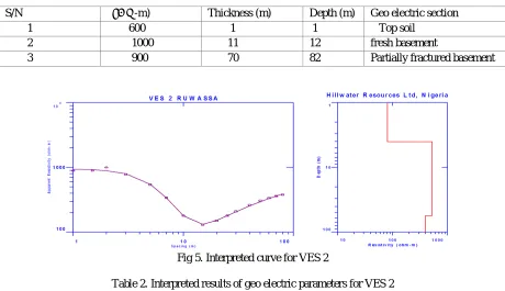
[image:5.612.76.536.347.612.2]Fig 5. Interpreted curve for VES 2
Table 2. Interpreted results of geo electric parameters for VES 2
S/N рa(ῼ-m) Thickness(m) Depth (m) Geo electric section
1 900 1 1 Top soil
2 150 16 17 Weatherd basement
Fig 6. Interpreted curve for VES 3
Table 3. Interpreted results of geo electric parameters for VES 3
S/N рa(ῼ-m) Thickness (m) Depth (m) Geo elecric section
1 100 1 1 Top soil
2 120 10 11 Weatherd basement
3 400 100 111 Fresh basement
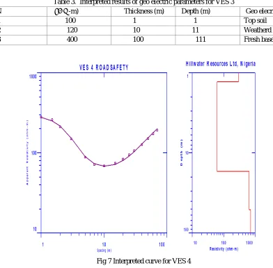
[image:6.612.66.541.652.723.2]Fig 7 Interpreted curve for VES 4
Table.4. Interpreted results of geo electric parameters for VES 4
S/N рa(ῼ-m) Thickness(m) Depth(m) Geo electric section
1 290 1 1 Top soil
2 80 10 11 Weathered
basement
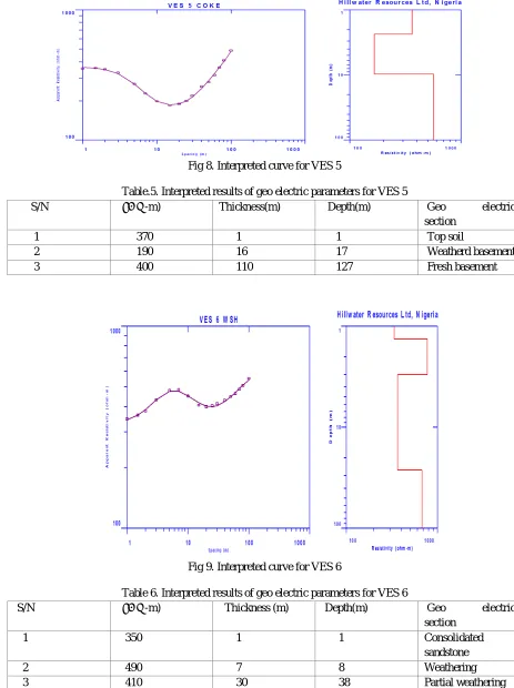
Fig 8. Interpreted curve for VES 5
Table.5. Interpreted results of geo electric parameters for VES 5
S/N рa(ῼ-m) Thickness(m) Depth(m) Geo electric
section
1 370 1 1 Top soil
2 190 16 17 Weatherd basement
[image:7.612.157.468.354.588.2]3 400 110 127 Fresh basement
Fig 9. Interpreted curve for VES 6
Table 6. Interpreted results of geo electric parameters for VES 6
S/N рa(ῼ-m) Thickness (m) Depth(m) Geo electric
section
1 350 1 1 Consolidated
sandstone
2 490 7 8 Weathering
3 410 30 38 Partial weathering
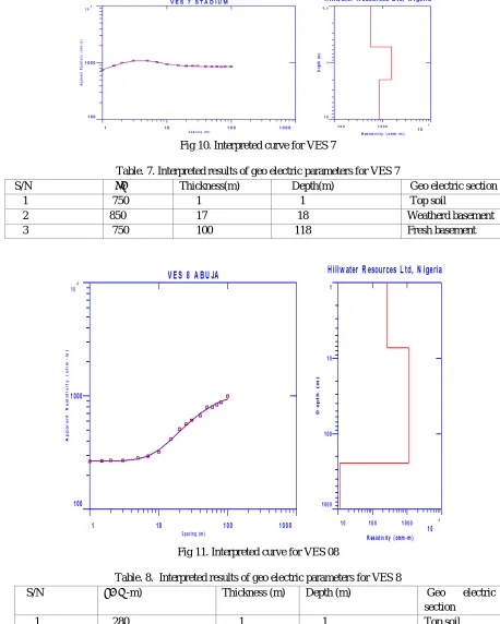
Fig 10. Interpreted curve for VES 7
Table. 7. Interpreted results of geo electric parameters for VES 7
S/N Ρa Thickness(m) Depth(m) Geo electric section
1 750 1 1 Top soil
2 850 17 18 Weatherd basement
[image:8.612.70.528.83.655.2]3 750 100 118 Fresh basement
Fig 11. Interpreted curve for VES 08
Table. 8. Interpreted results of geo electric parameters for VES 8
S/N рa(ῼ-m) Thickness (m) Depth (m) Geo electric
section
1 280 1 1 Top soil
2 300 10 11 Weatherd
basement
[image:8.612.121.481.285.586.2]Table 9. Summary of Curve types and potentials for groundwater
VES No. CURVE TYPE POTENTIALS FOR
GROUNDWATER
1 Q NO
2 H YES
3 A NO
4 H YES
5 H YES
6 A NO
7 Q NO
8 A NO
V. DISCUSSION
The data obtained for the eight (8) VES point were processed and interpreted using IXD interpex computer software licensed to Hill water resources Nig Ltd.The resulting curves from the interpretation were used to establish the existing subsurface units, and the geo electric properties of the various subsurface layers were used in delineating the acquiferous units in the study area. The results are presented in graphs, curves and tables. From the results, the following lithological sequence were established, top soil, consolidated sandstone, partially weathered basement, weathered basement and fresh basement.
The curve types obtained are Q, H, and A (table 8). The interpretation of the overall results reveals that VES 1 and 7 are of Q type curve indicating three geo electric section which compresis of top soil, weathered basement and fresh basement. Based on the apparent resistivity values of the VES point,the location canbe said to have no potentials for groundwater.
VES 2,4, and 5 are H type curve that reveal three geo electric section comprising of top soil, weathered basement, and fresh basement.The three locations have good potentials for ground water that varies in depth from 30 -55 m ±5 based on the resistivity values of the geo electric sections.
VES 3, 6 , and 8 are A curves comprising of three and four geo electric section. VES 3 and 8 are made up of top soil weathered basement and fresh basement,while VES 6, comprises of consolidated sandstone, weathered basement, partially weathered basement and fresh basement. The locations has poor ground water potentials. .
VI. CONCLUSION
This research was carried out based on the principles of resistivity survey which is the method of geophysical exploration that probe subsurface rocks using their geo-electric properties. 8 VES points were carried out and interpreted using 1XD interpex software licensed to Hill Water resources Ltd Nigeria. The interpreted result revealed three geo-electric layers. The first layer is the top soil, the second layer is the weathered basement and the third layer as fresh basement.In this research, out of eight (8) VES points investigated, 3 locations proved to have ground water potentials while the other five locations proves abortive. This three (3) locations are VES 5 at Cocoa cola depot, VES 4, at Road safety office, VES 2 at Ruwassa office. in view of this it draws attention for recommendation for drilling in those areas.
V.ACKNOWLEDGEMENT
REFERENCES
[1] Mbonu, P.D.C., Ebeniro, J.O . Ofoegbu, C.O and Ekine, A.S., 1991. Geoelectrical sounding for the determination of aquifer characteristics in part of Umuahia area of Nigeria. Geophysics. 56 (2) 284-291 .
[2] Nigerian Geologic Survey Agency, (2006). Geologic map of the study area.
[3] Nur, A., and Goji. M., 2005. Hydro-geoelectrical study in Takum and environs of Taraba State, NE Nigeria. Global Journal of Geological Sciences. 3 .109-115.
[4] Nur, A., and Ayuni. N.K., 2004. Hydro-geoelectrical study in Jalingo Metropolis and environs of Taraba State, N. E. Nigeria. Global Journal of Geological Sciences. 2. 101-109
[5] Nur, A., Obiefuna G.I, and Bassey, N.E., 2001. Interpretation of geoelectrical data of the Federal University of Technology Yola, N.E. Nigeria. Journal of Environmental Hydrology, 9 (3) 23-35
[6] Oyawoye, M.O., 1970. The Geology of Nigerian Basement Complex.Journal ofGeology and Mining. 32 (358), 87-92 .
[7] Shemang, E.M, and Umaru, A.F.M., 1994. Geophysical Investigation For Groundwater in the Area Around Jalingo Town,Journal of Geology and Mining. 30,(1), 81-83
[8] Talkington, R.W., 2004. Ground Water Availability in Fractured Crystalline Bedrocks; Example from the Sea of New Hempshire. In: Proceeding of 2004 annual International Conference.
[9] Taraba State Land and Survey, 1995. Political map of Jalingo, Taraba State , Nigeria. Published 1995.
[10] Umaru, A.F.M, and Schoeneik, K., 1992.The Hydrogeological Investigation of Aquifers of Taraba Area. A Journal of Mining and Geology, 28, (1456), 45-53
[11] Wright, E.P., 1992. The Hydrogeology of Crystalline Basement Aquifers in Africa.GeologicalSociety, London, Special Publications, 268p.