Impact of updating land surface data on micrometeorological weather simulations from the WRF model
Full text
Figure

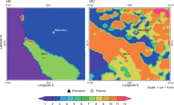
![Fig. 4. Complexity of the terrain (m) captured at models’ resolution (1 km). (a) Default (DEM [GTOPO 30])](https://thumb-us.123doks.com/thumbv2/123dok_us/8134562.2157393/7.850.137.732.127.495/fig-complexity-terrain-captured-models-resolution-default-gtopo.webp)


Related documents
Table 4.1: The length of time or the number of bright single pulses that went into the composite profile, the width, S/N and the RMS timing residuals from the composite profiles.
since. I am sure they didn’t lose their significance since they where published in the late 1940s, yet their popularity at our academy seems doubtful. I miss seeing the
In the lifelong health insurance contract that we consider in this paper, the deviation between the observed and the assumed medical inflation is taken into account ex-post as
To carry out an industrial test on the manufacture of some prestressed mono-block sleepers of activated fly ash concrete, a homogeneous concrete mixture, exempt of Portland
I, unconditionally waive, release, indemnify and forever discharge and hold harmless, POTTC Events, Pirates of the Treasure Coast, the Riverwalk Center, Veterans Memorial Park,
habitat points described direct improvements in species populations or habitats resulting from in situ or ex situ conservation interventions; program-management points related
JGP chords and improv Willie Myette Grand
One of the factors that have complicated research on this issue is the fact that Vasubandhu, in his Karmasiddhi, propagates the iilayavijnana in sections that he
