250
DRAWING OF THE TECHNICAL DOCUMENTATION FOR THE
COMMUNAL ROAD 151-DN 6- SECTIONN 1, DRĂGHICENI COMMUNE,
OLT COUNTY, BY COMBINED GPS USE – TOTAL STATION
CROITORU A., CĂLINA JENICA., BĂDESCU G., BUZATU C., CROITORU IRINA
University of Craiova, Faculty of Agronomy
Key words: total station, road, surveying, GPS
ABSTRACT
For drawing up the technical documentation of the Communal Road 151 – DN 6 –Section 1, located in the Drăghiceni commune area, Olt County, it was necessary the combined use of the modern GPS topography equipment – total station. The GPS technology was used to determine the points of the support network, and the total station to thicken it and raise the points on the ground.
The computational operations were performed based on the field data, thus obtaining the absolute coordinates of the points that delineate the studied land in the Stereographic Projection System 1970.
The drawing up of operations of the placement and delineation plan of the property body consist of representing the points that delineate the surface on a sheet of A3 format at a scale of 1:5000.
INTRODUCTION
Drăghiceni commune is an integral part of the Olt County, being located 7 kilometres from Caracal city and 45
kilometres from Craiova, the
administrative centre of the county.
Drăghiceni commune consists of Drăghiceni – the commune’s residence,
Liiceni and Grozăveşti. The entire
commune covers an area of 3200
hectares (www.primariadraghiceni.ro).
The connection with neighbouring
localities is made by means of the E 70 (DN 6) road.
WORK METOHDS
The documentation for the location and delimitation of the property bodies plans includes: a technical memo;
topographical descriptions of stable
points; the inventory with the coordinates of the old points used for the topographic lifting of the building, in Stereographic
System 1970; inventory with the
coordinates of points on the outline of the building; the location plan of the building.
In order to draw up the technical documentation of the real estate located in the Draghiceni commune, Olt County,
measurements and calculation and
reporting operations were carried out. The works were carried out in the
Stereographic Projection System 1970 and the field measurements were made
with a Topcon GR-3 GPS and a total
station Sokkia 530R.
GPS technology was used to determine the points of the support network and the total station to thicken it and raise the points of detail.
The support and lifting network was made up of geodetic support points:
- Old Points:
- GPS S1 point - materialized by metallic picket;
251
- GPS S9 point - materialized by metallic picket;
- GPS S10 point - materialized by metallic picket;
- New Points:
S3, S4, S5, S6, S7, S8.
From the S1 point a sustained traction was traced, after which the following station points were obtained: S3, S4, S5, S6, S7, S8, with closing on the S9 point.
The planimetric details were taken from the station points by the radius method.
The computational operations were made based on the field data, thus obtaining the absolute coordinates in the Stereographic Projection System 1970, of the points that delimit the studied land (Croitoru A., et al., 2012).
The drawing up of the of the location and delimitation plan of the property body consist in representing the points that delineate the surface on a sheet of A3 format at a scale of 1: 5000.
RESULTS AND DISCUSSIONS
For the preparation of the technical documentation, it is necessary to carry out: documentation and preparation of the planimetric lifting project; field operations (actual field measurement of all elements required for planimetric lifting); computing and reporting operations (Călina A., et al., 2015, Croitoru A., et al., 2016).
When designing the work project, it was necessary to study an old plan or
map, to perform the land recognition, to identify geodetic points in the area of
interest, known coordinate points
previously used in other works in the area, surface contours, support points, and lifting points in the plan.
From OCPI Olt was obtained a plan for framing in the area for the road sector in Draghiceni commune, Olt
County (fig.1).
Fig.1. Plan to fit into the area
The GPS technology was used to determine the points of the support network and for thickening it with a supported roading. The raising of the
points of detail was accomplished by the erasure method.
252
with double initialization. For receipt of corrections, the SLTN.2.3 permanent station was used.
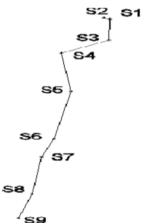
Within the GPS network, the 4 points have the following coordinates (table 1):
Table 1.
Inventory of coordinates for old points
Point name X (m) Y (m)
GPS S1 292762.892 438219.051
GPS S2 292775.043 438202.046
GPS S9 291294.141 437962.723
GPS S10 291176.815 437940.466
For the support network, a supported roading was started from the S1 point, pointing S2 point through points S3, S4, S5, S6, S7, S8, the closing being made on the S9 point pointing the S10 point (Fig. 2.).
Fig.2. Sketch of the support network
The measurements were
performed according to the technical regulations in force and were carried out with a Sokkia 530 R total station.
For the processing of data
gathered by modern technology the observation files were downloaded, after
which was made their conversion into special formats that can be loaded into calculation and compensation programs.
The calculations made with the
TopoLT program determined the
coordinates of the roading points (table 2).
Table 2
Inventory of coordinates for new points
Point no X (m) Y (m)
S3 292610.603 438220.8823
S4 292515.772 438087.469
S5 292231.839 438110.020
S6 291879.651 438062.943
S7 291747.009 438028.124
253
The determination of the
coordinates of the detail points was made by measuring the distances between the
station point and the radiated point and their directions.
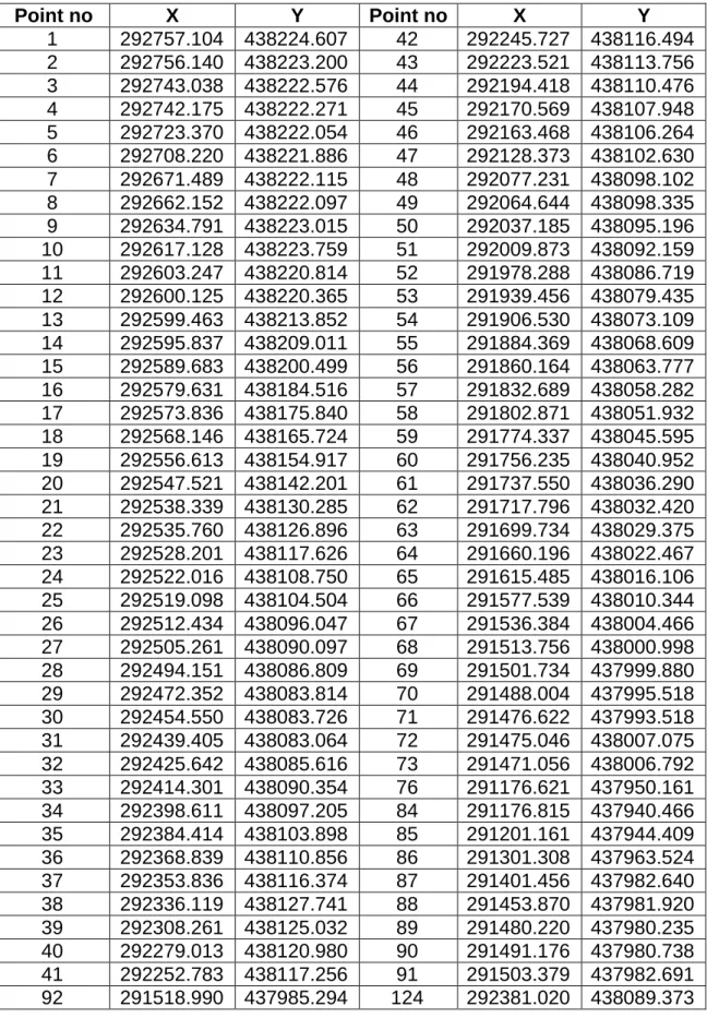
The details of the detail points are listed in table 3.
Table 3.
Inventory of coordinates for radiated points
Point no X Y Point no X Y
1 292757.104 438224.607 42 292245.727 438116.494
2 292756.140 438223.200 43 292223.521 438113.756
3 292743.038 438222.576 44 292194.418 438110.476
4 292742.175 438222.271 45 292170.569 438107.948
5 292723.370 438222.054 46 292163.468 438106.264
6 292708.220 438221.886 47 292128.373 438102.630
7 292671.489 438222.115 48 292077.231 438098.102
8 292662.152 438222.097 49 292064.644 438098.335
9 292634.791 438223.015 50 292037.185 438095.196
10 292617.128 438223.759 51 292009.873 438092.159
11 292603.247 438220.814 52 291978.288 438086.719
12 292600.125 438220.365 53 291939.456 438079.435
13 292599.463 438213.852 54 291906.530 438073.109
14 292595.837 438209.011 55 291884.369 438068.609
15 292589.683 438200.499 56 291860.164 438063.777
16 292579.631 438184.516 57 291832.689 438058.282
17 292573.836 438175.840 58 291802.871 438051.932
18 292568.146 438165.724 59 291774.337 438045.595
19 292556.613 438154.917 60 291756.235 438040.952
20 292547.521 438142.201 61 291737.550 438036.290
21 292538.339 438130.285 62 291717.796 438032.420
22 292535.760 438126.896 63 291699.734 438029.375
23 292528.201 438117.626 64 291660.196 438022.467
24 292522.016 438108.750 65 291615.485 438016.106
25 292519.098 438104.504 66 291577.539 438010.344
26 292512.434 438096.047 67 291536.384 438004.466
27 292505.261 438090.097 68 291513.756 438000.998
28 292494.151 438086.809 69 291501.734 437999.880
29 292472.352 438083.814 70 291488.004 437995.518
30 292454.550 438083.726 71 291476.622 437993.518
31 292439.405 438083.064 72 291475.046 438007.075
32 292425.642 438085.616 73 291471.056 438006.792
33 292414.301 438090.354 76 291176.621 437950.161
34 292398.611 438097.205 84 291176.815 437940.466
35 292384.414 438103.898 85 291201.161 437944.409
36 292368.839 438110.856 86 291301.308 437963.524
37 292353.836 438116.374 87 291401.456 437982.640
38 292336.119 438127.741 88 291453.870 437981.920
39 292308.261 438125.032 89 291480.220 437980.235
40 292279.013 438120.980 90 291491.176 437980.738
41 292252.783 438117.256 91 291503.379 437982.691
254
93 291541.445 437988.736 125 292395.275 438082.653
94 291582.590 437994.613 126 292411.274 438075.668
95 291620.531 438000.374 127 292424.200 438070.268
96 291665.409 438006.759 128 292441.019 438067.149
97 291705.136 438013.700 129 292456.573 438067.418
98 291723.350 438016.770 130 292476.442 438067.949
99 291743.674 438020.752 131 292500.182 438071.212
100 291762.778 438025.519 132 292515.333 438075.695
101 291776.797 438028.569 133 292526.098 438084.624
102 291813.041 438036.337 134 292533.586 438094.219
103 291816.468 438037.072 135 292536.704 438098.755
104 291875.850 438049.799 136 292542.608 438107.227
105 291882.106 438051.140 137 292550.158 438113.229
106 291882.256 438051.172 138 292556.699 438123.450
107 291888.537 438052.518 139 292567.413 438142.449
108 291893.350 438053.550 140 292577.749 438160.192
109 291991.098 438071.011 141 292583.810 438169.834
110 291997.370 438072.131 142 292589.686 438179.031
111 292003.637 438073.251 143 292598.392 438193.221
112 292009.901 438074.370 144 292604.323 438201.600
113 292018.971 438075.990 145 292610.370 438206.609
114 292030.348 438077.308 146 292616.662 438208.420
115 292036.665 438078.039 147 292626.434 438209.212
116 292147.475 438090.875 148 292645.002 438209.704
117 292154.789 438091.535 149 292665.377 438210.430
118 292269.955 438104.240 150 292665.377 438211.216
119 292281.093 438104.996 151 292693.775 438209.929
120 292308.785 438107.197 152 292724.036 438210.800
121 292333.603 438105.706 153 292757.778 438209.460
122 292352.310 438101.114 154 292760.068 438207.990
123 292366.049 438096.061
After determining the absolute coordinates of the points, they relate to a scale on a plan, after which they are merged according to the sketches on the ground, obtaining the ground plan that is the result of the planimetric elevations.
255
Fig.3. The location and delimitation plan Having the absolute coordinates of
the points, the property area was calculated by the analytical method, using one of the following calculation formulas:
2S = ( 1 1).
1
n nn
n
n Y Y
X
2S = ( 1 1).
1
n nn
n
n Y Y
X
2S =
n n n n
n X X
Y
1
1 1 )
( 2S =
. ) ( 1 1 1
n n n nn X X
Y
The total measured area of the road section in Draghiceni commune, Olt County is of 25209 sqm.
CONCLUSIONS
In order to carry out topographical
measurements to establish the
boundaries of the real estate subject to the project, it was necessary to build a thickening and lifting network using GPS technology combined with measurements with the total station.
The topographic measurements were performed in the “Stereograph 1970” projection system using a Topcon GR-3 GPS with 72 channels and two operating frequencies and a total Sokkia
530 R station. Data processing was done at the office using specialized software.
The location and delineation plan operations consist of representing the points that delineate the surface on a sheet of A3 format at a scale of 1:5000.
The surfaces were determined from the rectangular coordinates of the
contour points resulting from the
processing of the field measurements, based on the coordinates of the geodetic points and the points that constituted the support network.
BIBLIOGRAPHY
1. Croitoru Alin, Călina Aurel,
Buzatu Claudiu, Croitoru Irina - Topo-cadastral works required for entry in land register of a section from county road 677 a, Sirineasa Commune, Valcea county,
Analele Universităţii din Craiova, seria
Agricultură – Montanologie – Cadastru (Annals of the University of Craiova -
Agriculture, Montanology, Cadastre
Series)Vol. XLVI 2016, Pag. 340-344,
http://anale.agro-256
craiova.ro/index.php/aamc/article/view/47 2.
2. Croitoru Alin, Călina Jenica,
Miluţ Marius, Croitoru Irina- Use of
modern topographical equipment for draw up the technical documentation for rehabilitation of county road 643 C Horezu - Dobretu, Olt county, Analele Universităţii din Craiova, seria Agricultură – Montanologie – Cadastru (Annals of the University of Craiova - Agriculture, Montanology, Cadastre Series)Vol. XLVI
2016, Pag. 345-349,
http://anale.agro-craiova.ro/index.php/aamc/article/view/47
3/442.
3. Croitoru Alin, Călina Jenica, Miluţ Marius, Croitoru Irina - Surveing of Nicolae Romanescu park located in Craiova, Analele Universităţii din Craiova,
seria Agricultură-Montanologie-Cadastru,
vol XLII/2, 2012, Ed. Universitaria, Craiova, pag. 331-336, ISSN 1841-8317, revistă indexată în bazele de date Index Copernicus, Ulrichs, CABI, DOAJ.
4. Aurel CALINA, Jenica CALINA,
Alin CROITORU - Study on building of
planimetric network stakeout for a commercial space using combined technology gps-total station Scientific Papers. Series E. Land Reclamation,
Earth Observation & Surveying,
Environmental Engineering. Vol. IV, 2015 Print ISSN 2285-6064, CD-ROM ISSN 2285-6072, Online ISSN 2393-5138, ISSN-L 2285-6064.
5. XXX - Manual de utilizare Statie Totală Sokkia 530 R.
6.www.ancpi.ro
7.