III BIOSTRATIGRAPHY
Illa LOCAL POLLEN ZONES AS A BASIS FOR THE PALEOECOLOGICAL RECONSTRUCTION
Biostratigraphy, like litho- and chronostratigraphy, aids the reconstruction of the paleoenvironmen-tal evolution. Just as in Chs. II and V lithostratigraphy is used in the reconstruction of the sedimentary-geological paleoenvironment, so here and also in Ch. V biostratigraphy is used in the reconstruction of the vegetational development in that environment. For this purpose, palynological investigations of several cores have been carried out. The biostratigraphic zonation of the pollen sections studied has primarily a local significance: the local pollen zone is defined on the basis of the composition of the pollen deposition at a certain place and a certain depth in the sedimentary bed sequence. Because of this, the pollen zone is, in the terminology of the International Stratigraphic Guide (HEDBERG 1976, p. 50), an assemblage zone; one might speak of a local pollen assemblage zone.
The locally deposited pollen may be partly derived from the local vegetation, partly from the regional vegetation, partly, e.g. via rivers, from remote areas (the so-called long-distance transport), and partly from eroded older deposits. The interpretative discrimination of these components is in the first instance not taken into account in establishing the local pollen assemblage zone boundaries, for pollen zonation should be strictly descriptive: 'The pollen zone is a feature of the diagram alone' (FAEGRI 1975, p. 201). Discrimination between the components (local, regional, etc.) requires a comprehensive procedure. The pollen zones within the section should be compared with each other. The section should be compared to neighbouring sections. Additional paleobotanical results can play an important role (e.g. fruit analysis). The pollen zonation should be compared to the regionally established and possibly dated pollen zonation. Knowledge of the ecology of the species concerned is of course a prerequisite. In particular, the geological situation of the section should be known in detail: many variations in pollen sections (pollen diagrams) can be explained as a direct response to changes in the geological environment, especially where there are many vertical changes in lithology.
Illb METHODS
Slices of 1 cm thickness were taken from the cores (5 cm in diameter) to be studied by pollen analysis. With a 1 cm sampling interval in most cores consisting of peat, gyttja or peaty clay (see Ch. Ie), this resulted in contiguous sampling. In other cases, especially in clay beds with their usual sampling interval of 5 cm, non-sampled gaps remain. From the slices taken from the cores, the cen-tral part (c. 4 cubic cm) has been used for the preparation of the pollen residue. In the case of the Standard boring, the remainder was used for fruit analysis.
The preparation of pollen residues from the samples involved the following phases: KOH pretreat-ment, sieving, light Schulze reaction (to remove as much plant tissue as possible), KOH post-treatment, acetolysis, bromoform separation, light HF post-treatment. The fruit samples were prepared by simply boiling in a 5% solution of KOH.
The pollen analysis was carried out with the aid of phase-contrast microscopes. Pollen grains were counted using manually operated counters (specially designed for this purpose), and accumulators on these allowed a constant pollen sum to be kept.
The local pollen zonation is in general based on changes in the tree pollen curves, in the AP (tree pollen)/NAP (herbs) ratio, and in the NAP curves of especially Gramineae, Cyperaceae and Umbel-Uferae. In the tables with the pollen-zone descriptions, generally only those pollen taxa are men-tioned whose percentages differ significantly from the under- and overlying zones. These tables should be read from bottom to top. The fungal spores are not mentioned in these tables, but are briefly discussed in Ch. IIIl.
It should be stressed that the pollen zonation is literally local for every single section. Thus the zone numbers do not relate to any of the regional zonations (e.g. that by ZAGWIJN & VAN STAALDUINEN 1975, p. 111 f.), nor is there any relation between the zone numbers of the individual sections in this study.
IIIc POLLEN ANALYSIS OF BORING MOLENAARSGRAAF H l l l O (STANDARD BORING) IIIc.1 Pollen zones
The Uthology and lithostratigraphy of the Standard boring of the Molenaarsgraaf study area have been discussed in Ch. IIa.1 (see also Table 1). For the topographical position see Fig. 3. The boring is situated c. 1 km north of the Hazendonk river dune. For the geological situation see Fig.*6 (profile I). The hthological sequence given in the pollen diagram (Fig.* 12) and in Fig. 13 can be traced in profile I.
The foUowing are represented from left to right in the pollen diagram: lithology, depth in cm below (mowing) surf ace, local pollen zones, sampling depths, tree pollen curves, AP/NAP ratio, NAP curves, spore curves. At the bottom, percentage scales are shown. The lines drawn within the shad-ing of some spore curves show one tenth of the real values.
The studied section measures 9.20 m and comprises 466 samples. In the diagram 26 zones have been distinguished; these have been described in Table 3.
IIIc.2 Some general remarks
Considering the whole diagram, the foUowing zone boundaries can be observed as the main ones: 1. the transition from zone 8 to zone 9; the Alnus values below this transition are in general lower than above it, the reverse applies to the values of Corylus, Pinus, Tilia and Ulmus.
2. the transition from zone 20 to zone 21; this is characterised by a strong rise of Fagus values; the Alnus values decrease somewhat, but remain in general higher than below the transition from zone 8 to zone 9.
3. the transition from zone 22 to zone 23; here, the high Alnus values are restored.
Using these three zone boundaries, the 26 zones can be combined into four main zones: I (1-8), II (9-20), III (21-22), IV (23-26), as indicated in Fig. 13.
A comparison between the column with the pollen zones and the lithological column (Fig. 13), reveals a strong relationship between pollen deposition and geological development: most zone boundaries coincide with transitions in the lithology. From this comparison it also appears that in the organic beds more pollen zones have been distinguished than in the clastic beds. In the first instance, this may be explained by the fact that the sampling density is higher in the organic beds than in the clastic (clay) beds.
Phrag-mites peat beds (see Fig. 13), are characterised by high values of, among others, Gramineae, of which Phragmites is indeed the main component. The determination of Phragmites pollen is possible by making use of the phase-contrast adjustment on the microscope; this determination was carried out incidentally as a check. It is not unlikely that part of the Gramineae pollen derives from grasses other than Phragmites. For the environment under consideration (generally speaking, a fluviatile swamp environment), Glyceria maxima, G. fluitans and Phalaris arundinacea should be mentioned in particular (cf. VAN DONSELAAR 1961).
Pollen zones 11 to 20 and 23 to 26, coinciding with lithostratigraphic units ol 2-4 and ol u (see the scheme in Fig. 5) contain high Alnus percentages. These organic beds are generally developed as wood peat. Because of the high Alnus pollen percentages and also of a few wood-sample determina-tions, it may be postulated that most wood peat is Alnus wood peat. In most pollen diagrams from wood peat layers in the Western Netherlands, Alnus appears to dominate in the tree-pollen composi-tion. In pollen diagrams Hazendonk I and Molenaarsgraaf I and II, published by LOUWE KOOIJMANS (1974, figs. 39, 66 and 67), — sections only 1 km distant from the Standard boring under consideration here — Alnus values are high in peat beds that correspond hthostratigraphically with organic beds ol 2-4 and ol u. In pollen diagrams at Goudriaan and Benschop, pubhshed by VERBRAECK (1970, figs. 43 and 44; both sections from the eastern part of the fluviatile coastal plain), the Alnus curve shows high values in the wood-peat beds. Other examples of an Alnus domi-nance in pollen diagrams of stratigraphically comparable peat layers, can be found in JELGERSMA (1961, especially diagram Alphen aan de Rijn), PONS & WIGGERS (1959-60, fig. 34, a peat profile near Abcoude) and HARTMAN (1968, diagram Schipluiden).
IIIc.3 Supply of pollen by river water
Former investigations
In interpreting the pollen content of river clay beds in the Western Netherlands, one has to take account of the supply of pollen by river water from the hinterland, especially the Rhine catchment area. This has been stressed by FLORSCHÜTZ & JONKER (1939, p. 690), ZAGWIJN (1965, p. 84), HARTMAN (1968, p. 9) and DE JONG (1970-71, p. 76). In this connection, Picea, Abies and Fagus are particularly mentioned, as well as Pinus. It is supposed by these authors, that part of the pollen of other species will also have been supplied by rivers. The special mention of Picea, Abies and Fagus is connected with the fact that these tree species did not occur naturally in the Netherlands in the periods concerned.
We think, in agreement with the above-mentioned authors, that part of the pollen in the deposits in the study area has been supplied by the large rivers from the whole catchment area, and thus from Middle Europe. Below, we shall deal with this question in detail, to see which pollen taxa were most strongly influenced by this fluvial transport.
Fagus, Abies and Picea
South-lig. \3. Pollen zones in boring Molenaarsgraaf HlllO (Standard boring). For lithological legend, see Fig. *9. The cross at 5 m below N.A.P. indicates a sampling hiatus formed by a piece of wood.
o:
E <
c Z
o. o
u n È
èE
3
-ci 4
• 5
-ol 3-4
cl 3
ol 2-3 8
-cl 2b
ol 2a-2b
-10-c l 2 a
•^TT?
cl 1
ol b
KF Ol o
o
CL
E °
5 $
o-° •o n
IK 155
670 678
7 0 5 7 1 0 720
823 630
925 930
961 9 6 5
3340480 BP
4370 + 120 BP
4170 t 60 BP
4570175 BP
5590+70 BP
6 0 6 0 1 8 0 BP
6500+90 BP 6420 + 70 BP
6520 + 100 BP 6720 ± 70 BP
73701100 BP
ern Germany, thus mainly from the German Mittelgebirge which forms an important part of the Rhine catchment area (FIRBAS 1949, p. 229 f.).
Abies and Picea are the only pollen taxa in the diagram which caimot have been derived from the regional vegetation, but instead must have been supplied from the hinterland. In Subboreal pollen sections from Southern Germany, Abies attains high values, as does Picea in some regions (FIRBAS 1949, p. 248 f. and 203 f. respectively). In zones 21 and 22, both situated in the Subboreal clay bed cl 4, Picea and Abies reach relatively high values.
Pinus and Tilia
In order to define which other pollen taxa during the Subboreal may have been supplied to a significant extent from the fluvial hinterland, the pollen content of clay bed cl 4 may be compared to that of the under- and overlying (wood-)peat beds. Pollen taxa that occur mainly or nearly exclusively in the clay bed may be attributed more positively to river supply than taxa that attain about the same or higher values in the clay bed than in the peat beds. In this way, for this Subbo-real clay bed, besides the pollen of Fagus, Picea and Abies, one may regard that of Tilia and Pinus as partly river borne. The remaining tree-pollen taxa and also most herb pollen may be regarded as mainly regional and local.
The section covering zones 4 to 8 in the pollen diagram coincides with clay beds cl I -l- cl 2 and the intercalated peat beds ol 1-2 and ol 2a-2b. According to the C-14 dates of the boring, this section can be dated as middle-Atlantic. In the study area three pollen sections of gyttja deposits (organic lake-deposits) have been studied, that correlate chronostratigraphically with this section ( cl 1 -I- cl 2) of the Standard boring. These pollen sections are discussed in Chs. Illg, Illh and lllk. The pollen content of these gyttjas difTers strongly from that of the chronostratigraphically correlating clay beds of the Standard boring with respect to the Pinus and Tilia percentages. These are generally much lower in the gyttja sections. Assuming that in principle air-borne pollen will be present in equal amounts in clay and in gyttja, the higher values of Pinus and Tilia in the clay beds can be explained by river supply.
A strong argument in favour of this, at least concerning Pinus, can be found in the simultaneous occurrence of Fagi4S and Picea at the depth of the Pinus maxima in zone 8 (the Atlantic clay bed cl 2; Fagus certainly did not grow in the Netherlands during the Atlantic). Very high Pinus values have also been found in the Atlantic clay beds of boring Leerdam S322 I (see Ch. Illd). Such high Pinids pollen sections scarcely occur in Atlantic pollen sections from the Netherlands. Again, such high values are mentioned by FIRBAS (1949, p. 133 f.) for certain parts of Middle- and Southern Germany, and thus for the fluvial hinterland. FIRBAS' appendix with pollen diagrams, especially figs. 87-92, is illustrative in this respect; pollen diagrams from lower regions within the Mittelgebirge in the western part of Germany show a strong Pinus dominance in zone VI (the older part of the Atlantic).
Pinus pollen has also been found in important percentages in the intercalating peat beds ol 1-2 and ol 2a-2b. These are however rather clayey developed (as Phragmites peat). Possibly, river-borne Pinus pollen is easily trapped in such a Pkragmites-max^h envirormient because of its floating capa-city (see also DE JONG 1970-71, p. 77). TRAVERSE & GINSBURG (1966) stress that aquatic deposition of Pinus pollen depends strongly on sedimentological factors such as turbulence. ZAGWIJN (1965, p. 85) noticed concentrations of Pinus pollen in the clayey, topmost bed of sedimentary sequences, which also points to increased Pinus pollen deposition at decreased turbulence and/or stream velo-city.
here, as is recognized for the whole Holocene from most Dutch pollen diagrams.
The Tilia curve in the same section of the Standard boring (zones 4-8) shows very pronounced max-ima in the clay. In the Atlantic clay bed in the Leerdam study area (boring Leerdam S322 L see Ch. Illd), Tilia also attains very high values compared to those in the peat beds. In the previously mentioned Atlantic gyttja sections from the Molenaarsgraaf study area (see Chs. Illg, Illh and Illk) such high Tilia values are not generally found. The first two of these sections are situated in the river-dune field in the western part of the study area, and therefore exhibit the dry-tree growth on the river dunes. Moreover, Tilia values are generally not particularly high in Dutch pollen sections from Atlantic (organic) deposits.
As in the Subboreal, in the Atlantic an important part of the Tilia pollen will have been carried down by the rivers from the hinterland. That the Tilia pollen in the zones concerned should partly also have originated from a local source, is apparent from zone IV in gyttja section H2I78 (Ch. Illg): Hme trees also occurred to some extent on the river dunes in that period.
With the comparative argument used here it can be shown next, that, during the Atlantic, Quercus pollen was partly supplied by river water from the far hinterland, albeit to a far lesser degree than Tilia—Quercus being the main tree on the river dunes (see Chs. Illg, -h and -k), and that most other pollen taxa can be interpreted as more distinctly regional and local. Assuming the pollen content of the clastic (clay) deposits to be partly supplied by river water from the hinterland in periods that the Netherlands themselves were also rich in forests impUes a very large supply of pollen by rivers to the coast. This conclusion was reached previously by HARTMAN (1968) in a palynological study of several cores of clastic sediment from the Western Netherlands, mainly by establishing pollen con-centrations. In studies of marine palynology in Marine Geology 4 (see among others the before-mentioned study by TRAVERSE & GINSBURG 1966) it has been shown that a lot of pollen, especially saccate grains such as Pinus, is transported by river water into the sea.
Local circumstances and reworking
In the preceding paragraph, supraregional fluvial supply of pollen was contrasted with local/regional supply. A number of nuances are introduced in the interpretation of the pollen zones in the follow-ing sections, especially in connection with the lithostratigraphy and lithology and with paleoecologi-cal circumstances such as the structure of the vegetation. An example of the latter concerns the interception of pollen from e.g. the dune vegetation by the local vegetation of the wet areas and by bordering Corylus. An example of the former (the lithostratigraphy) is the quite characteristic development of clay bed cl 3 with its dominance of local tree pollen ( mainly Alnus) over suprare-gional tree pollen because of the fact that this clay bed has been deposited in an environment with many swamp-forest stands. Further, on the basis of lithological differences between the clay beds cl 1, cl 2a and cl 2b, the latter may be expected to show the strongest influence of river supply in its pollen content because of a larger density of fossil channel fills.
.^"
\-' v"^ «"<i.^^^+^
^^ 607e809e e 10 10 ie 3e30 4050 10 3030 40 10 30 10 30 ie 10 10 10 eie 3e 10101010101010 30 leieieie
IIIc.4 Fruit analysis
Local supply and depositional circumstances
The results of fruit analysis of the same core as used for pollen analysis (Fig. 14) may yield impor-tant supplementary Information, especially concerning the local components in the pollen diagram. In view of this, it is supposed that the fruits have not been supplied over very long distances. This will hold for the clastic beds less clearly than for the organic beds. However, the longer the distance of river transport of the fruits, the more they will have been wom, and so the less easily they will be distinguished and counted. In the diagram (Fig. 14), the absolute numbers of fruits have been plot-led. To enable comparison with the pollen percentages of identified fruits, the corresponding pollen curves from the diagram (Fig.* 12) have been copied in the left half of Fig. 14. Taking into con-sideration several reservations regarding fluctuations in the fruit diagram due to differences in the volume of material sampled, the following statements and conclusions can be made.
Despite the differences in samphng interval between the clay beds and the organic beds, it can be stated that in clastic beds cl 1, cl 2b and cl 4 strikingly little fruit numbers have been found, espe-cially when compared to cl 3. Clastic beds cl 2b and cl 4 consist generally of weakly humic, slightly sandy clay, cl 1 of weakly humic, non-sandy clay; beds cl 2a and cl 3 consist generally of strongly humic, non-sandy clay. Apparently, the higher energy environment of deposition of clay beds cl 2b and cl 4 was less suited to the production and/or deposition of fruits than the quieter environment of deposition of clay beds cl 2a and cl 3.
Alnus, Scirpus, Alisma
Most Alnus fruits have been found in wood-peat beds ol 2-3 and ol 3-4, and also in the upper part of the intercalated clay bed cl 3. This agrees well with the Alnus pollen curve, and moreover confirms the importance of the boundary between pollen zones 8 and 9, which was pointed out above (Ch. IIIc.2) as the most important zone boundary on the basis of the Alnus pollen percen-tages.
Scirpus fruits have been found almost exclusively in the gyttja layers and in the lower part of the humic clay bed cl 3. The higher percentages of Cyperaceae pollen in the pollen zones concerned (zones 12 and 13), will have originated from Scirpus to a large extent. The most likely Scirpus species for the lacustrine environment of deposition of the gyttjas is Scirpus lacustris. The continua-tion of the higher Scirpus fruit numbers in the gyttja of organic bed ol 2-3 into the overlying humic clay bed cl 3 provides one of the indications that the clay of bed cl 3 has also been deposited in a lacustrine environment.
The fruits of all Carex species have been combined in one curve because of their low values. So far as Identification to species level has been possible, the fossils are mainly Carex disticha, C. pseudo-cyperus and C. acuta, all of which are species of wet, eutrophic environments (HEUKELS & VAN
OOSTSTROOM 1968).
One of the most conspicuous examples of the possible value of a fruit diagram in the interpretation of a pollen diagram can be found in the fruit curve of Alisma. Virtually wherever peaks occur in the Alisma pollen curve, peaks also occur in the fruit curve. This means that for Alisma pollen, and probably also for many other herb-pollen taxa, a local origin is more important than a regional one.
Batrachium, Umbelliferae, Urtica
Just as Scirpus fruits make a narrower Identification at genus level possible for a part of the Cypera-ceae pollen curve, so do Batrachium fruits for the RanunculaCypera-ceae pollen. A number of peaks in the
have been found exclusively in the gyttjas of organic bed ol b and ol 2-3 and in the humic clay bed cl 3 (pollen zones 2 and 12-1-13). Batrachium would grow well in the lacustrine environment of deposition of the gyttjas and possibly also of the humic clay bed cl 3.
The large family of Umbelliferae, one of the most important herb-pollen taxa, is represented in the fruit diagram to some extent as Oenanthe aquatica, Sium erectum and 5. latifolium. Fruits have also been found of Umbelliferae not specifically identified. The three species named above are typical of a fresh-water marsh environment.
Urtica pollen has only rarely been found in the Standard boring. Additional information can be obtained from the fruit curve, where, at the depth of pollen zone 9, a large number of Urtica fruits have been identified. In a similar way, VAN DER WIEL (in prep.) found Urtica fruits in a peat section at the border of the Hazendonk river dune, at a level where high Urtica pollen values would be expected (on the basis of archeological arguments) but were absent. She ascribes this to oxidation of the thin-walled Urtica pollen because of water-level variations. This explanation, particularly a temporary fall of the average local water level, possibly also applies to the above-mentioned zone 9 of the Standard boring (see Ch. IIIc.5).
Several of the most abundant fruits (among others Alisma and Batrachium) have also been found by FLORSCHÜTZ & JONKER (1939) in a section near Wijk bij Duurstede, situated near the northeastern border of the fluviatile coastal plain of the Western Netherlands.
IIIc.5 Interpretation of the pollen zones
In the interpretation of the pollen zones of the Standard boring, regular reference will be made to the lithological background, especially to the profiles (Figs. *6,*7 and*8) and the lithostratigraphic scheme (Fig. 5). Although in Ch. V an integrated paleoecological reconstruction of the various landscape clements in the study area is given, in this section several of these landscape clements are involved in the interpretation of the pollen zones. This particularly concerns the river dunes, the natural levees and the stream ridges. Stream ridges in the immediate vicinity of the Standard boring stand out clearly in profile I (Fig.*6). The position of the river-dune complex is shown in Fig. 36 (Ch. V), which illustrates the extent of dune sand and loam in the whole study area. This map also shows isolated small river dunes outside the larger dune complex. Near the Standard boring, dune sand was found in a channel fill of bed cl 2b in such quantities, that in the direct surroundings of the Standard boring a small, low river dune had probably also been present, but had been eroded away completely by the time bed cl 2b was deposited. At every point in the study area one should appreciate the likelihood that a small, low river dune exists or existed in the immediate vicinity: despite the high density of borings, the probability of hitting just the smallest river dunes is not very large.
Zone 2 (961-930 cm). At the locahty of the boring a small, shallow lake was present. This is shown not only from the lithology (a gyttja), hut also from the pollen of Nymphaea and Nuphar. The lim-ited extent and depth of the lake is indicated not only from the lithology (it is a rather peaty gyttja pointing to shallow water and/or proximity of the shore) and the lithostratigraphic profile (Fig.*6), hut also from the nearby presence of Typha angustifolia, Cyperaceae, Sparganium, Gramineae and Cruciferae {Rorippa and/or Nasturtiuml), which would grow close to the shore and at shallow places in the lake. The fruits of Batrachium confirm the open-water nature of the environment of deposi-tion.
Away from the lake, going from low to high on the surface of the Kreftenheye Formation, grew Alnus and Salix, Fraxinus and Ulmus, and Quercus, with Corylus in the undergrowth and along the forest edges. Pinus seems to have largely vanished.
The increase of Alisma and Typha angustifolia in the topmost part of the pollen zone points, together with the lithology (the gyttja is peatier in the upper part), to an environment with less open water, in other words to a partial infilling of the lake by plant growth.
Txine 3 (930-925 cm). This narrow zone is situated just at the hthostratigraphic transition from the gyttja-like peat to the overlying clay. Both the Quercus and the Alnus stands seem to have decreased strongly, at least locally. In contrast, Corylus occupied a more important place on the somewhat higher parts of the landscape: in the underlying zones Corylus was probably found mainly as under-growth and along the forest edges, but now it may have invaded, together with Hedera and Vibur-num, the open places in the forest. In the lower parts of the landscape the vegetation of Phragmites with ferns (probably Dryopteris thelypteris) expanded. According to the fruit analysis, in the Phrag-mites vegetation locally occurred Alisma as a continuation from the top of the underlying zone. The isolated peaks of Pinus pollen may point to local remnants of Pinus on the highest parts of the river dunes, its pollen being probably less effectively filtered out because of the supposed decrease in the Quercus stands.
Zone 4 (925-875 cm). On the river dunes not only had the Quercus vegetation apparently been restored, but also Tilia had occupied a (more important) place. Along the borders of the dunes, at the transition to a wetter environment, Ulmus would have been growing, and there may also have been important Corylus growth along the forest edges. Ulmus, Quercus and Corylus may also have been growing locally on possible natural levees of the small gully situated nearby, the filling of which has been found in clastic bed cl 1; zone 4 completely coincides with clay bed cl 1 in the Stan-dard boring.
The peak of Pinus pollen at 910 cm depth coincides with an isolated find of two Fagus pollen grains. As Fagus had not yet immigrated into the Netherlands in the period of deposition of this clay bed (c. 7000 BP, see Ch. IV), its pollen had apparently been supplied by river water from the hinterland, and this will also have been the case with part of the Pinus pollen as well (see also Ch. IIIc.3). In the marsh itself, Alnus stands would have been present on the somewhat higher parts, with bord-ers of Salix, hygrophilous grasses (mainly Phragmites), Sparganium, ferns and Typha angustifolia. At the transition to the overlying zone, and thus towards the end of the clay sedimentation, the vegeta-tion of grasses (Phragmites) expanded strongly, together with Alisma and Cruciferae.
Table 3. Dcscriplion of pollen zones in boring Molenaarsgraaf HIUO (slandard boring).
26 65-45 cm. Alnus values high, slightly decreasing in the top, where Salix increases. Higher Pinus values. AP/NAP-ratio again as in zone 23; Umbelliferae values still important.
25 76-65 cm. Restoration of high Alnus values. Salix values remaining important. Fagus values slightly increased. Decrease of AP/NAP-ratio by very high values of Umbelliferae. Increase of Cruciferae. Alisma and Rubiaceae.
24 85-76 cm. High Salix values. Decrease of Alnus. Rather important values of Fraxinus. At 83 cm small peaks of Com-positae tubuliflorae and Ranunculaceae.
23 121-85 cm. High values of Alnus. Rather low values of Corylus, Fagus and Tilia. Salix and Pinus continuously present. Picea practically disappeared. Rather high AP/NAP-ratio. Some small peaks of Cyperaceae. Important increase of Umbelliferae. Small peaks of Cruciferae, Plantago lanceolata, Ranunculaceae. Fern spores strongly decreased. High values of Bryophyta. Maximal values of Zygnemataceae.
22 165-121 cm. Fagus values decreasing to zero. Important values of Pinus and Picea. Salix practically absent. Values of Corylus, Quercus and Tilia decreasing in the top of the zone. There also lower AP/NAP-ratio, due to peaks of Cyperaceae and Cruciferae (together with some Cerealia grains). Rather important values of fern spores; increase of Bryophyta.
21 415-165 cm. High Fagus values. Alnus values variable, generally lower than in zones 9-20. Salix nearly continuously present. Pinus values low. rising in the top of the zone. Maximal Picea value in this zone. Important values of Corylus, Quercus and Tilia. High AP/NAP-ratio, fluctuations clearly related to Gramineae curve. Small peaks of Cyperaceae. Umbelliferae, Ranunculaceae and Typha angustifolia. Fern spores continuously present but with strongly fluctuating values.
20 435-415 cm. Higher Corylus, lower Quercus values. High AP/NAP-ratio; Umbelliferae values decreasing. Higher Bryophyta values.
19 457-435 cm. Slightly higher values of Salix, Pinus, Quercus. Lower AP/NAP-ratio by higher values of Gramineae, Umbelliferae and Cruciferae. Small peak in Alismataceae curve.
18 468-457 cm. Restoration of high Alnus values. Very high AP/NAP-ratio.
17 482-468 cm. Lower Alnus, higher Corylus values. Fagus continuously present. Increased values of Quercus and Tilia. Hedera slightly more important. Higher values of Umbelliferae, Alisma, Lythrum, Cruciferae, Ericaceae. Practically the only zone with Rumex hydrolapathum (not presented in the diagram).
16 491-482 cm. Higher Alnus and Pinus, lower Corylus and Tilia values. Extremely high values of monolete psilate fern spores.
15 495-491 cm. High values of Corylus; lower values of Alnus and Quercus. Small peaks in thecurvesof Fagus, Tilia and Ulmus. Rather high values of Gramineae and Sparganium. Slightly increased values of Zygnemataceae. High values of Bryophyta.
14 508-495 cm. Low values of Corylus. Small peaks of Salix and Fraxinus. Increase of Umbelliferae values. Peaks in the curves of Cyperaceae and Rubiaceae.
12 678-670 cm. Important peak of Corylusopposing lower values of Alnus. Quercus values verylow. Smal! peakof Ulmus. AP/NAP-ratio restored to nearly that of zone 8. Decrease of Gramineae values. Low values of fern spores.
11 705-678 cm. Constant hiigti Alnus values. Corylus values rather low, increasing towards tfie top of the zone. Continuous occurrence of Fraxinus. Rising AP/NAP-ratio. High values of Cyperaceae. Rather important values of Gramineae, Lythrum, Rubiaceae, Compositae tubuliflorae; increase of Filipendula values in the top of the zone. High values of monoiete psilate fern spores.
10 710-705 cm Minimum in AP/NAP-ratio. Important peak of Quercus opposing lower values of Alnus. Small peaks of Pinus and Fraxinus. Very high values of Gramineae. High values of Cyperaceae and Typha angustifolia.
9 720-710 cm. Strongly increased Alnus values. Increase of Gramineae towards zone 10. Small peak of Umbelliferae. High Bryophyta values.
8 823-720 cm. Rather high values of Quercus, Tilia, Ulmus and Pinus. Contemporaneous occurrence of Fagus and Picea in middie part of the zone. Increased values of Salix in lower part of the zone. Corylus important, with peaks in upper part of the zone. High AP/NAP-ratio. Ericaceae peaking in middie part of the zone. In lower part of the zone rather high values of Cyperaceae, Umbelliferae, Typha angustifolia and Alisma
7 830-823 cm. Higher values of Corylus and Ulmus, lower values of Alnus and Quercus. Important peak of Gramineae. Small peak of Cruciferae. Increased values of Typha latifolia, Alisma and Ranunculaceae.
6 863-830 cm. Important peaks of Pinus, Tilia, Betuia, Umbelliferae, Alisma and monoiete psilate fern spores. 5 875-863 cm. Strongly fluctuating values of Corylus, Pinus and Alnus. Rather low AP/NAP-ratio; rather low values of
Quercus and Tilia, slightly increased values of Ulmus. Very high values of Gramineae. Decreasing Cruciferae values. Peak of Alisma. Maximal value of Botryococcus; slightly increased Zygnemataceae values. High values of Bryophyta.
4 925-875 cm. High values of Tilia, Quercus, Gramineae and Sparganium. Increased values of Salix in upper part of the zone. Maximal value of Cruciferae in this zone, at the transition to zone 5.
3 930-925 cm. High values of Corylus and Pinus; low values of Alnus and Quercus. Small peak of Viburnum. Important peaks of Gramineae and monoiete psilate spores.
2 961-930 cm. Rather high values of Alnus and Quercus. Important values of Typha angustifolia, Sparganium and Nym-phaea. Nuphar continuously present. Regular occurrence of Cruciferae and Rumex acetosa. Peaks of Alisma and Typha latifolia in the top of the zone.
1 965-961 cm. Peaks of Pinus, Gramineae, Valeriana, Bryophyta.
The strong decrease of Quercus and Tilia and the expansion of Corylus may point to prehistorie influences in the form of wood cutting. The lower Tilia values may however also relate to decreased river supply (see Ch. IIIc.3).
Zone 6 (863-830 cm). This pollen zone coincides entirely with the strongly humic clay bed belonging to hthostratigraphic unit cl 2a. Clay sedimentation took place in quiet, shallow water with abun-dant growth of ferns (Thelypteris), Umbelliferae and Alisma, and less abunabun-dant (or at a greater dis-tance from the section) Phragmites and Typha angustifolia. The Umbelliferae fruits found in this bed come from Sium erectum and S. latifolium, both belonging to an environment of shallow, quiet water, with or without varying water level (WESTHOFF & DEN HELD 1975, p. 129). In contrast to these two species, Oenanthe aquatica, another Umbelliferae species characteristic of the fluvial environment, prefers faster flowing water (VAN DER VOO & WESTHOFF 1961, p. 253). In the upper few cms of the zone, the increase of Typha latifolia and Mentha (Labiatae) points to increasing water stagnation (ibid.).
On the river dunes the Quercus vegetation was restored. Also some Betuia occurred presumably on the higher parts of the river dunes; these might have functioned as pioneers in the regeneration of the {Quercus) forest after the supposed wood cutting. Ulmus maintained itself probably on the lower parts of the dunes, together with Corylus, and, still closer to the marsh, Alnus.
Zone 7 (830-823 cm). The local vegetation consisted of a Phragmites marsh with rather open places where Alisma, Typha latifolia and presumably Rorippa/Nasturtium and Ranunculaceae (Ranunculus lingua and/or sceleratusl) occurred. The rather open nature of the Phragmites marsh is also apparent from the lithology: the bed concerned, ol 2a-2b, has been developed here as peaty clay, so there was continuous clay sedimentation during peat growth. The higher Corylus and Ulmus values might be ascribed to the vegetation of the nearby natural levees of the channel in clastic bed cl 2 (see profile I, Fig.*6). The Corylus and Ulmus pollen might have reached higher percentages in the sediment concerned because of a decreased supply of especially Tilia and Pinus pollen by river water. Apart from that, there is the possibility that, by a slight fall of the water table, the levee emerged some-what, causing a basinward extension of the levee forest; this might apply particularly to Corylus since it can function as a quickly invading bush.
Zone 8 (823-720 cm). In the lower two dm of the zone, a sequence has been recorded from the Phragmites marsh of the preceding zone to an environment with large areas of open water: Phrag-mites largely gave way to Alisma (pollen and fruits), Mentha (fruits), Umbelliferae (fruits of Oenanthe and Sium erectum), Cyperaceae and Typha angustifolia. The higher Salix values in the lower part of the zone are probably also to be explained as signifying much wetter conditions (by a relative rise of the water table).
In the upper part of the zone the AP/NAP-ratio is very high, and this is one of the indications of the probably permanently open-water nature of the basins (see also Ch. Vb).
The zone largely coincides with clastic Hthostratigraphic unit cl 2b, which comprises a large number of channel fills (see e.g. profile I, Fig.*6). On the natural levees of these gullies, one of which was situated very near the section (see profile I), stands of Ulmus, Fraxinus and possibly Corylus, with Alnus along the wet flanks, will have occurred. On the highest parts of the levees Quercus may also have grown.
vegeta-tion on the river dunes at the time of deposivegeta-tion of this zone on the basis of this secvegeta-tion alone. The gyttja sections at the foot of the river dunes (see Chs. Illg and -h) provide better information on this point.
Zone 9 (720-710 cm). An intensive filhng of the former open-water basins had set in with Phragmites marsh as well as Alnus swamps. The not yet completely enclosed nature of the Phragmites marsh may be indicated by the occurrence of Umbelliferae and Alisma. The large number of Unica fruits found in this zone points to a local accumulation of nutrients (phosphates and nitrates). This may have been caused in three ways. Firstly, an accelerated decomposition of plant material on the nearby natural levees or stream ridge of clastic bed cl 2b may have come about by a water-level fall. Secondly, Urtica may have been part of the vegetation standing on drifted plant material washed ashore along a nearby lake (cf. WESTHOFF et al. 1971, p. 179; see also Ch. IIIj). Thirdly, human prehistorie activity as a cause of nutrification, e.g. by wood cutting on the before-mentioned stream ridge, should not be excluded.
On the natural levees, or the stream ridges resulting from these, the forest stands consisted of a presumabiy rather open vegetation of Corylus and Ulmus, with Alnus along the wetter flanks.
Zone 10 (710-705 cm). The vegetation in most of the lower parts of the area consisted of a Phrag-mites marsh with much Typha angustifolia and Cyperaceae. At the transition to the higher parts of the area, at the flanks of the stream ridges and possibly also of the river dunes, probably a tem-porary decrease in the growth of Alnus and Corylus took place (perhaps by an anthropogenic cause; another explanation might be a further increased fall of the local water level). Because of this, Quercus pollen, coming from the yet higher parts of the area, could reach more easily the locahty of the section, i.e. without being filtered out by Corylus and Alnus trees. Probably the same holds for the pollen of Fraxinus, and to a lesser extent also for Ulmus. This explanation is based partly on TAUBER'S theory concerning the importance of the 'trunk-space transport' of tree pollen: the pollen supply from the interior of a forest may be hampered strongly by a dense bush in the edge of the forest (TAUBER 1977, p. 66). ImpUcitly this process plays a role in the interpretation of several zones of this and other sections.
Zone 12 (678-670 cm). On the nearby stream ridge of lithostratigraphic unit cl 2 (see profile I, Fig! 6) the Quercus stands had probably partly given way to Corylus and to a lesser degree also to Ulmus. Phragmites growth had decreased considerably. The peaks of Umbelliferae pollen (presum-ably Sium erectunt, in view of the fruit analysis) and of Filipendula pollen, prob(presum-ably point to a more open nature of the Phragmites marsh; this might also be indicated by the occurrence of Batrachium. All this is in good agreement with the lithology. The zone concerned is situated in the transition (within organic bed ol 2-3) of the wood peat to the overlying gyttja. The gyttja, a lake deposit, points to an increased rise of the local water level causing not only large openings in the marsh vegetation, but also important changes in the vegetation on the stream ridge by means of increas-ingly wetter soil conditions.
Zone 13 (670-508 cm). At the locality of the section, a lake came into being, in which Nymphaea, Batrachium and Nuphar were growing. At shallow spots, especially near the shore at the transition to the Alnus swamp, a vegetation of Scirpus (presumably S. lacustris, see also Ch. IIIc.4), Phragmites (possibly also other hygrophilous grasses), Thelypteris ferns, Umbelliferae, Sparganium and Typha angustifolia existed, with Salix probably at the edge of the swamp forest itself. On the somewhat higher parts in the swamp forest Fraxinus and Ulmus also presumably grew. On the river dunes stood a Quercus forest with Tilia, and probably also Ulmus at the transition to the swamp; there would also have been important undergrowth and edges of Corylus.
The interpretation of a lacustrine environment is, so far as the lower part of the zone is concerned, in good agreement with the lithology — a gyttja (lake deposit). As the pollen content of the overly-ing clay (formoverly-ing the upper part of the zone) does not differ substantially from that of the gyttja itself, it may be assumed that the clay was also deposited in a lacustrine environment. The clay belongs to lithostratigraphic unit cl 3. This is generally developed as a strongly humic clay bed wedging out in some places in the organic layer complex ol 2-4 (see the lithostratigraphic scheme in Fig. 5).
The tree pollen composition is strongly dominated by the Alnus forests, lying as islands or strips between the extensive lakes (see Ch. IIa.3 and profiles I and II, Figs.*6 and*7). The pollen from the Quercus forests on the river dunes could reach the locality of the section by wind transport over the lakes.
The higher values of the previously mentioned shore plants in the middie part of the zone may indi-cate a temporary extension of the swamp forests in the direction of the lakes. In general, the even nature of most pollen curves in this zone may be regarded as an indication of a quiet environment, where no or few sedimentological changes took place.
Zone 14 (508-495 cm). The vegetation described in the preceding zone along the shore of the lake, had come nearer to the locality of the section, which may point to a decrease in water depth and the beginning of the process of infilling of the lake. To a larger degree than in the preceding zone, Umbelliferae (among others Sium erectum, according to the fruit analysis), Rubiaceae (probably Galium palustre) and Cyperaceae other than Scirpus would have occurred in the shore vegetation.
combination with Sparganium, in ox-bow lakes (VAN DONSELAAR 1961). Lithostratigraphically the zone is situated just in the transition from clay bed cl 3 to wood-peat bed ol 3-4; this agrees with the infiUing nature of the vegetation. In this shallow-water environment, Zygnemataceae algae were floating.
The Quercus vegetation on the river dunes had decreased, causing the Corylus undergrowth to expand and/or to blossom more effectively. Tilia and Ulmus are relatively better represented in the pollen diagram because of the Quercus decrease. This Quercus decease can possibly be ascribed to prehistorie wood cutting.
Zone 16 (491-482 cm). At the spot stood an Alnus forest with an important undergrowth of ferns (compare with zone 11: Athyrium and/or Thelypteris). According to the fruit analysis, various Carex species were growing there too. Only few pollen from the river dunes could penetrate the local forest; Corylus pollen may have done so, but these could also have been supplied from the higher parts in the Alnus forest.
Zone 17 (482-468 cm). The swamp forest had become locally more open. At these open spots, in an environment of shallow water, Umbelliferae (various species), Alisma plantago-aquatica, Cruciferae (probably again Rorippa and/or Nasturtium), Lythrum and Rumex hydrolapathum grew. On higher spots nearby stood Quercus and possibly also Tilia, with edges of Corylus and presumably also Ulmus. These higher localities might have been the river dunes, the pollen from which would have been able to reach the locality of the section more easily through the openings in the swamp forest. Besides, there is the possibility that by compaction differences in clay bed cl 3, a certain relief had originated, and that on its higher parts Quercus with Corylus may have grown instead of only Alnus. Hedera may also have occurred in such a dry place in the swamp forest. Finally, in view of the increased Fagus pollen values, one should consider the possibihty of a slightly increased fluvial sup-ply of tree pollen.
Zone 18 (468-457 cm). The Alnus swamp forest had (locally) been closed again, according to the very low herb-pollen percentages. The possible Quercus stands in the vicinity (see zone 17) seem to have maintained themselves.
Zone 19 (457-435 cm). Again, the Alnus forest had become locally more open. Apart from the species mentioned in zone 17, grasses and various Carex species also grew in these openings, prob-ably in very shallow water. Salix also seems to have occurred in these openings. Again, the Quercus stands (with Ulmus and Corylus) on the higher grounds had maintained themselves.
Zone 20 (435-415 cm). From the consistently high values oi Alnus pollen and fruits and the very low herb-pollen values, it may be concluded that the swamp forest was locally more closed again. From the lithology and lithostratigraphy (see Fig. 13) it appears that in this swamp forest the clay sedi-mentation of clastic bed cl 4 had already begun.
may however also have been the cause. In connection with these possible prehistorie influences, the high Corylus values, at least in the topmost part of the zone, may also point to a regeneration of forest on abandoned fields, as GROENMAN-VAN WAATERINGE et al. (1968) presume for prehistorie occupation terrains of the Vlaardingen culture in the Western Netherlands beach barrier region.
Zone 21 (415-165 cm). An environment with much open, moving water existed in the basins. This may be concluded from the high percentage of river-borne tree pollen (see Ch. IIIc.3), from the high AP/NAP-ratio and from the Uthology (an only weakly humic clay). Along the borders of the river dunes and natural levees grew Alnus, Salix, grasses and ferns. Grasses and ferns probably also grew at shallow points in the basins. On the higher parts (dunes and levees) Quercus, Ulmus, Fraxinus and perhaps also some Tilia would have grown.
The impressive change from an extensive swamp forest to mainly open water took place at the beginning of this thick zone.
Zone 22 (165-121 cm). From the increase of Alnus and herb pollen towards the end of the zone it appears that the open-water basins were starting to fill up. The increase of Pinus pollen values may be explained by more quiet sedimentation conditions (see also Ch. IIIc.3).
The coincidence of higher values of Chenopodiaceae pollen with a small isolated peak in the Cerealia pollen curve points to prehistorie human influences. Possibly the higher Cruciferae values are also coimected with this.
Zone 23 (121-85 cm). In the area an Alnus swamp forest has been established again (compare with zones 16-19). In small open places in this forest pools with Zygnemataceae algae and a vegetation of Cyperaceae and Umbelliferae existed. The presence of Plantago lanceolata and of Cruciferae may point to continued human influences, e.g. on the vegetation of the nearby Schoonrewoerd stream ridge.
Zone 24 (85-76 cm). Increasingly wetter conditions in the Alnus forest are apparent from the increase in Salix. The expansion of Fraxinus might point to the same process on the Schoon-rewoerd stream ridge (increasingly wetter flanks).
Zone 25 (76-65 cm). Locally an opening developed in the swamp forest of Alnus and Salix, with an abundant growth of Umbelliferae and, to a lesser degree, also Alisma and Cruciferae (probably again Rorippa and/or Nasturtium). The origin of this opening might point to a temporary relative rise of the local water table (see also zone 24).
Zone 26 (65-45 cm). The Alnus swamp forest had locally been closed again. At some distance from the section some openings with Umbelliferae and (edges of) Salix probably still existed.
IIIc.6 Chronological implications
diagram. Using just this Middle-European pollen for dating purposes (by a comparison with e.g. FIRBAS' zones) would lead to a circular argument; for it was on the basis of datings (C-14 datings) that the presence of this Middle-European pollen was inferred (Ch. IIIc.3).
The dating method mentioned (comparing with FIRBAS' zones for the Middle European pollen) might indeed be used at sections from the perimarine fluviatile coastal plain, if C-14 dates are lack-ing. It would be interesting to elaborate the possibilities of this method in more detail.
An extensive series of C-14 datings of the present Standard section is available for a detailed chro-nology (see Ch. IVb.1). Nevertheless some general pollen-analytical datings are also inferred (see Ch. IVb.3).
Illd POLLEN ANALYSIS OF BORING LEERDAM S322 I Choice of the sampled section
Boring S322 I is lithostratigraphically representative for the Leerdam study area. The location of this boring relative to the central river dune in this area can be seen in Fig. 4. For the lithostratigra-phy of the section see profile IV (Fig.*10) and the scheme in Fig. 11.
The choice of the sampled part of the section (see Fig. 16) has been dictated by the lithostrati-graphic correlation with that part of the Standard section of the Molenaarsgraaf study area (namely the transition from clastic bed cl 2 to organic bed complex ol 2-4), where the most important pollen-analytical zone boundary (the boundary between zones 8 and 9, see Ch. IIIc.2) is situated.
Fig. 16. Pollen zones in boring Leerdam S322 1. For lithological legend, see Fig. *9.
Boring Leerdam S 322 I
Q.
•O n Oo o O n u IP IC
IC '|'|'|'|'|'|"''j IE
iP I C iP I B 4 — iP IIA lep I D lep I D lep I C lep
liiiiiliil
I B5
-lep
•::;] I A 326 338 352 367 407 421 467 487 504 536 6090170 BP General remarks
tree pollen carried down by river water from the hinterland (esp. Pinus and Tilia) occur. The very high Pinus percentages are probably connected with quiet sedimentation conditions, as discussed in Ch. IIIc.3.
Peat bed ip (pollen zones II and IV), like the lithostratigraphically correlative organic bed ol 2-4 in the Molenaarsgraaf area, shows a dominance oi Alnus pollen and low values of river-borne pollen. In the intercalated clay bed ie (zone III) fluvially suppUed pollen is present in percentages corresponding to those in clay bed cl 3 at Molenaarsgraaf (zone 13).
Interpretation of the pollen zones
Zone IA (536-504 cm below land-surface). In an open-water basin few local pollen was deposited in proportion to extraneous pollen. On the natural levees and the river dune, Quercus and Tilia prob-ably grew on the higher parts and Ulmus, Corylus, Alnus and Salix on the lower parts.
Zone IB (504-481 cm). During a partial filUng in of the basin a rich herb community had been locally established (see Table 4), and Alnus could expand probably basinward from the natural levees.
Zone IC (481-467 cm). In agreement with the lithology (being midway that of zones IA and IB), the pollen content also shows components of both zones.
Zone ID (467-421 cm). The pollen of Corylus, Quercus, Tilia and Ulmus would have been derived partly from the fluvial hinterland, and, in view of the high values in comparison with the underlying zones, partly also from the local vegetation on the natural levees and river dunes. Alnus and Salix would have grown mainly at the transition from the natural levees and river dunes to the basins. At shallow spots in the basin Cyperaceae occurred, and to a lesser degree grasses, Sparganium and Alisma.
Zone IIA (421-407 cm). In the basin a swamp forest had been established, consisting of Salix and Alnus. In the undergrowth Cyperaceae occurred and at somewhat open places Umbelliferae and Typha grew. The Urtica pollen may have been derived from the undergrowth of the swamp forest, but also from the nearby Middelkoop stream ridge. In the latter case there may have been a similar and simultaneous prehistorie influence as supposed for zone 9 of the Standard section of the Molenaarsgraaf area. On this stream ridge, and also on the river dune, stands of Quercus, Ulmus and Corylus would have occurred.
Zone IIB (407-367 cm). The swamp forest still consisted, at least locally, mainly of Alnus. At open places Umbelliferae and Solanum dulcamara grew. The peak of Cyperaceae pollen in the upper part of the zone points possibly to increasingly wetter conditions in the swamp forest. On the nearby stream ridge stood Quercus and also Rhamnus.
Table 4. Description of pollen zones in boring Leerdam S322 1.
IV 337,5-326,5 cm. Restoration of high Alnus values. Decreased Quercus and Tilia values; slightly increased Ulmus values. Very high AP/NAP-ratio. Bryophyta values strongly increased.
III 352,5-337,5 cm Important peaks of Quercus. Tilia, Fraxinus, Fagus and Picea. Salix values decreasing towards the top of the zone. Important decrease of Alnus values. In lower part of the zone peaks of Typha angustifolia, Solanum dulcamara and Iris.
II C 367,5-352,5 cm. High Salix values in lower part of the zone. Peak of Umbelliferae.
II B 407,5-367,5 cm. High Alnus values and high AP/NAP-ratio. Decreased but still important Salix values. Maximal value of Rhamnus in this zone. Peaks of Cyperaceae, Umbelliferae, Solanum dulcamara and Rubiaceae.
II A 421-407,5 cm. High Salix values. Alnus values increasing. Strongly decreased values of Corylus, Pinus, Quercus, Tilia, Ulmus. Increasing AP/NAP-ratio. Decreasing Cyperaceae values. Peak of Urtica dioeca.
I D 467,5-421 cm. Maximal values of Tilia, Ulmus and Corylus. High Quercus values. Increased values of Salix at base and in top of the zone, Fagus, Carpinus, Picea and Abies present. Slight increase of Fraxinus values. Rather strongly fluctuating AP/NAP-ratio due to peaks of mainly Cyperaceae, also of Gramineae, Typha angustifolia, T. latifolia and Alisma. Increasing values of fern spores.
I C 486,5-467,5 cm. Restoration of high Pinus and Tilia values. Decreased values of Alnus, Quercus and Ulmus. High AP/NAP-ratio.
I B 503.5-486,5 cm. Decrease of Pinus and Tilia values, increase of Alnus, Quercus and Ulmus values. Important peaks of Gramineae, Cyperaceae, Umbelliferae, Typha angustifolia, Sparganium and Cruciferae.
I A 536,5-503,5 cm. High values of Pinus and Tilia. Alnus. Corylus. Salix, Picea, Quercus, Ulmus and Betuia present in rather low values. Carpinus present in one sample. High AP/NAP-ratio.
Zone III (352-338 cm). In a large opening in the swamp forest (in an open-water environment), clay sedimentation took place. Along the shore, among others Typha angustifolia, Solanum dulcamara and Iris would have grown. Quercus, Tilia, Ulmus, Fraxinus and Corylus would have been present on the stream ridge and the river dune.
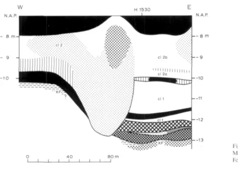
Ille POLLEN ANALYSIS OF BORING MOLENAARSGRAAF H1530 in cooperation with G. J. van Dijk
-Depression filling
Boring Molenaarsgraaf Hl530 is situated above a depression in the surface of the Kreftenheye For-mation. Fig. 17 shows a lithostratigraphic cross-section at the western rim of this depression; from a comparison with e.g. profile I (Fig.* 6), the rather exceptional nature of this depression becomes apparent: it is the deepest found in the study area. The lowermost organic bed of the Westland Formation (bed ol b, the 'basal peat') has been developed here as a gyttja bed 1 m thick. Overlying this are thick clay beds, belonging to lithostratigraphic units cl 1 and cl 2.
Pollen analysis of the gyttja bed in the lower part of the depression was carried out because it was expected that here an older part of the paleoenvironmental history would have been registered than in the Standard section. The lower part of the overlying clay bed cl 1 has also been analysed. Therein a peat bed occurs with a very sharp lower boundary, which points to a non-in situ forma-tion of the peat bed. The sampling interval is 1 cm in the gyttja and the clay, and 3 cm in the peat bed.
— 9
—10
Fig. 17. Profile at boring Molenaarsgraaf H1530.
Kor lilhological legend, sec Fig. *9.
General remarks
Zones I and II (see Fig. 18, Table 5 and App., Fig. n) show clear Preboreal and Boreal spectra. A C-14 dating at the base of zone I confirms the Preboreal age (see Ch. IVb.1 and Fig. 28). The (few) pollen of among others Quercus and Tilia at the base of zone I has presumably been reworked from older, e.g. Eemian deposits, or might have been suppUed by percolation through the rather coarse fluvial sand of the Kreftenheye Formation from younger deposits.
Zone II shows spectra characteristic of the older part of the Boreal. Gradually increasing values of
Alnus and Ulmus, as found in section Leerdam S322 II (Ch. Illf) and characteristic of the
Zone III can be placed entirely in the Atlantic period. At the sharp transition from zone II to zone III we suppose a rather prolonged hiatus during the younger Boreal and probably also the early Atlantic. In the Uthology (see Fig. 18) a clay bed only 1 cm thick has been found at the exact depth of this hiatus; this clay shows affinity to the loam (Kreftenheye Formation) because of its dark-grey colour and its stickiness. Superposed on this clay bed is a sand string, likewise only 1 cm thick; on the basis of its variegated colour it may be interpreted as (primary or secondary) dune sand.
lig. 18. Pollen /ones in boring Molenaarsgraat Hl 530. For lilliological legend, see Fig. *9.
Boring Molenaarsgraaf H 1530
11 (LI (LI > o. o l _ EP
( j i 0 0 (U c 0 N c OJ • 5 E s .E 5
Q . P
dl (LI
T3 a •— tn CL •D n
Cl 1 r H D 1035
1044 1072 1078 1132 1148 1170 1180 1 2
-ol b c l 1
-nc " U B "
1035 1044 1072 1078 1132 1148 1170 1180 ol b UTA 1035 1044 1072 1078 1132 1148 1170 1180 ol b ÏÏB 1035 1044 1072 1078 1132 1148 1170 1180 1 3
-ol b
I A — I —
1035 1044 1072 1078 1132 1148 1170 1180 KF 1035 1044 1072 1078 1132 1148 1170
1180 97704100 BP
Interpretation of the pollen zones
Zone I (1180-1170 cm below land-surface). On the surf ace of the Kreftenheye Formation (dunes and loam) stood a presumably rather open forest of Pinus and Betuia. Occurrences of Hippophae and Artemisia may be regarded as the remains or continuation of a Late-Weichselian vegetation. In view of the Uthology (gyttja), a lake must have existed in the local depression. Along its shore grew
Typha angustifolia and/or Sparganium.
Zone IIA (1170-1148 cm). The forest was presumably more closed and consisted mainly of Pinus. At the shore of the depression, besides Phragmites and Typha angustifolia /Sparganium, Cyperaceae and ferns also grew. In the lake itself occurred Nuphar and Sagittaria.
Zone IIB (1148-1132 cm). On the dunes and the higher parts of the /oaw-surface Corylus expanded, whether only as undergrowth of the Pinus forest, and/or (see FIRBAS 1949, p. 152) as substantive Boreal Corylus forest. The lower parts of the /oaw-surface were colonised by Salix bushes, indicating temporary wetter conditions in the area by inundation and/or rise of the local groundwater level.
and grasses (probably Phragmites) on the lower parts of the /oaw-surface. Along the shore of the lake occupying the depression stood a vegetation of Phragmites. Cyperaceae, Typha
angustifolia / Sparganium, fems and Umbelliferae. In the lake itself grew Nymphaea and Myriophyl-lum.
Zone IIIB (1078-1072 cm) and zone IIID (1044-1035 cm). At the lowest spots in the area, such as here in the depression, fluvial inundation and sedimentation occurred. Part of the pollen (esp. of Tilia, cf. Ch. IIIc.3) was apparently suppüed by river water from the hinterland. The vegetation in the area would have been largely the same as during the formation of zone UIA.
2Lone IIIC (1072-1044 cm). The zone coincides lithostratigraphically with the non-in situ formed Phragmites-peat layer. The sharp lithological lower boundary of the peat layer might point to a floating-mat origin; the varied composition of the herb pollen would agree with this.
Table 5. Description of pollen zones in boring Molenaarsgraaf H1530.
III D 1044-1035 cm. Increase of Tilia (up to 18%), Ulmus(c. 10%), Fraxinus(c. 4%). AP/NAP-ratioc. 65%, NAP mainly con-sisting of Gramineae, Cyperaceae, Sparganium/Typha angustifolia and Rumex hydrolapathum. Values of fern spores decreasing strongly upwards.
III C 1072-1044 cm. Sharpdecreaseof AP/NAP-ratioat base of the zone toe. 30%; increasinggradually upwards toe. 65% again. AP as in zone III A, Pinus and Alnus slightly higfier, Corylus slightly lower. NAP mostly consisting of Gramineae (more than 100% at base), Cyperaceae (c. 30%), Sparganium/Typha angustifolia (c. 30%) and Typha latifolia (15% at base). Small peaks of Rubiaceae (2%), Chenopodiaceae (3%), Compositae tubuliflorae (7%), Thalictrum (3%), Rumex hydrolapathum (7%). Extremely high values of monolete psilate and echinate fern spores.
III B 1078-1072 cm. Peaks of Tilia (18%), Ulmus (30%), Pinus (35%), Abies (2%), Hedera (4%), monolete psilate fern spores (100%).
III A 1132-1078 cm. Sharp transition from zone II Btozone III A. Nearly all species present in rather constant values: Alnus c. 30%, Corylus c 25%, Quercus c. 17%, Tilia c. 2%, Ulmus c. 7%, Pinus c. 10%. AP/NAP-ratio decreased to c. 65%, NAP mainly consisting of Gramineae (c. 40%), Cyperaceae (c. 7%), Sparganium/Typha angustifolium (c. 7%), Umbelliferae (c. 2%). Important peak of monolete psilate fern spores at base of the zone (45%).
II B 1148-1132 cm. Pinus gradually decreasing from c. 90 to c. 50%. High Salix values characteristic of this zone (c. 20%, peaks up to c. 40%). Corylus increasing upward to 40%. Quercus increasing in the upper part of the zone to c. 5%. AP/NAP-ratio very high (c. 90%), NAP consisting practically only of Gramineae. Sharp decrease in fern spores. II A 1170-1148 cm. Constant very high Pinus values (c. 90%). Betuia c. 10%; in upper part of the zone slight increase of
Corylus and Salix. AP/NAP-ratio c. 85%; Gramineae c. 10%, other NAP mainly Cyperaceae, Typha latifolia, Sparganium/Typha angustifolia, Nuphar, Sagittaria. Important peaks of monolete psilate fern spores (up to 60%).
Illf POLLEN ANALYSIS OF BORING LEERDAM S 322 II • in cooperation with J. Nap
-Depression tilling
Like pollen section Molenaarsgraaf Hl530 (Ch. Ille), pollen section Leerdam S 322 II relates to an organic deposit (gyttja and gyttja-like peat) in a depression in the surface of the Kreftenheye Forma-tion. The aim of the analysis of the section is to compare the early-Holocene development of the Leerdam area with that of the Molenaarsgraaf area.
Fig. 19. Pollen zones in boring Leerdam S322 II. For lithological legend,
see Fig. *9. Boring Leerdam S 322 1
C Z
£ $
"O n
i r
O o
ai O o x;
Icp
iir
9
-Icp ir
Icp ir
Icp
I B
Icp
IA
KF
ES
a O
-o n
8 3 3
9 6 0
9 8 2
1014 9 4 0 0 * 1 2 0 BP
The lithostratigraphic position of the section can be seen in profile IV (Fig.* 10). The samphng inter-val is 1 cm in the gyttja, 3 cm in the overlying gyttja-like peat (see also Fig. 19) and 1 cm in the transition from the latter to the overlying clay.
General remarks
The section shows a gradual transition from the Boreal in zones I and II to Atlantic in zone III (see Table 6, Fig. 19 and App., Fig. o). The section does not show the hiatus (in the later part of the Boreal), as its counterpart, section Molenaarsgraaf Hl530.
Table 6. Dcscriplion of pollen zones in boring Leerdam S322 II.
III 868-833 cm. Gradual transition from zone II to zone III. Rise of Alnus to c. 35%; fall of Pinus to c. 15% (witfi streng fluctations). Values of Corylus and Quercus same as in upper part of zone II. Salix c. 10%. Increase of Ulmus to c. 10%; increase of Tilia in top of the zone to 13%. NAP mostly consisting of Gramineae (c. 30%), Cyperaceae (mainly in upper part of tfie zone, c. 10%), Typha angustifolia (5-10%) and Umbelliferae (5-10%). Peaks of Filipendula (8%, in lower part of ttie zone) and Solanum (3%, in upper part of the zone). Fern spores reduced to c. 2-3%.
II 960-868 cm. Quercus gradually increasing to c. 25%. Corylus values very gradually decreasing from base to top of the zone (to 10-20%). Pinus in lower part of the zone c. 30%, gradually increasing to c. 50% in upper part of the zone. Betuia gradually decreasing from c. lOtoc. 1 % . Salix gradually increasing from c. 1 toe. 10%. Alnus discontinuously present in very low values, increasing gradually in the top of the zone. Ulmus values same as in zone I B. AP/NAP-ratio c. 70%; Gramineae c. 20-25%; upward increasing values of Cyperaceae, Typha angustifolia, Umbelliferae, Cruciferae, Nuphar, Chenopodiaceae and monolete psilate spores; important peaks of all these in upper part of the zone, esp. of Cyperaceae (up to 35%), Typha angustifolia (up to 20%) and Umbelliferae (up to 20%).
I B 982-960 cm. Corylus values higher (c. 65%), Pinus values lower and strongly fluctuating. Ulmus values slightly increas-ed (c. 2-3%). Gramineae increasincreas-ed but strongly fluctuating. Maximal values of Thalictrum in this zone (up to 5%).
I A 1014-982 cm. AP dominated by Corylus (c. 45%) and Pinus (c. 40%). Betuia c. 10%; Salix c. 1 -2%. Quercus and Ulmus nearly continuously present in very low values. AP/NAP-ratio c. 60%, NAP mainly consisting of Gramineae (c. 45%); Cyperaceae c. 5%, Typha angustifolia c. 5%, Myriophyllum c. 5%, Artemisia c. 2-3%.
Interpretation of the pollen zones
Zone IA (1014-982 cm below land-surface). On the higher parts of the surf ace of the Kreftenheye Formation (river dunes and ham) stood Pinus, Corylus and some Betuia. On the lower parts of the /oaw-surface Phragmites and Salix would have occurred, and during inundations some ham may still have been deposited there. In the depression itself a lake formed with a vegetation of Gram-ineae, Cyperaceae and Typha angustifolia along the shore and Myriophyllum in the water itself.
Zone IB (982-960 cm). Corylus temporarily expanded at the cost of Pinus, and Ulmus established itself in the area. Apart from these changes the vegetation was similar to that of zone IA.
Zone II (960-868 cm). On the river dunes and possibly also on the higher parts of the /oaw-surface stood Quercus, Ulmus, Pinus and Corylus, and, on the lower parts of the ham, Salix. In the depres-sion Gramineae, Cyperaceae, Typha angustifolia, Cruciferae and Umbelliferae grew in shallow water.
Illg POLLEN ANALYSIS OF BORING MOLENAARSGRAAF H2178 Depression filling in dune field
In the western part of the Molenaarsgraaf study area a (completely buried) complex of river dunes is present (see e.g. Fig. 36). In its strongly undulating relief lies, at boring H2178 (see for the posi-tion Fig. 3), a small depression, reaching down to 10 m below N.A.P. and partly infilled by gyttja and peat (see Fig. 20). Lithostratigraphically these organic beds belong to the basal peat (bed ol b in the local terminology). This organic depression fiüing has been studied palynologically in order to reconstruct the older, on the basis of the depth below N.A.P. probably Atlantic, forest cover of the river dunes. Some pollen samples have also been taken from the underlying deposits (loam and dune sand). During the sampling it was noted that a thin sand layer also occurred in the organic depres-sion filüng, with a lithology similar to that of the river-dune sand (see Fig. 21).
Fig. 20. Pro file at boring Molenaarsgraaf H2178. For lithological legend, see Fig. *9.
y o u n g t r
dcpositi
Interpretation of the pollen zones
Boring Molenaarsgraaf H 2178 Boring Molenaarsgraaf H 2118
c z
D-O
•o n
èR
1 0
->,
CT) O O
o o.
c in
£ $
Q.O
"O n
CL E< > D.
E o u t : c Z O
t_ d l O) o
c o
N C
0 . 0 <U il
O o
H 1- 0 0)
"ö a O O) dl
"D i3 j = in • ^ i a • o n
cl 3
8
9
-Fig. 21. Pollen zones in boring Molenaarsgraaf H2178. For lithological legend, see Fig. *9.
6 5 0
Fig. 22. Pollen zones in boring Molenaarsgraaf H2118. For lithological legend, see Fig. *9.
Zone II (962-891 cm). Only in the upper 30 cm of the river-dune sand did sufficiënt pollen appear to be present for a rehable analysis. It is assumed that the pollen was illuviated after the dune-sand deposition. A detailed discussion of this process of pollen illuviation in sand soils is given by HAVINGA (1974). Also bioturbation may have played a role here; it was shown by AHLBRANDT et al. (1978) that in the surface of sand dunes intensive bioturbation can occur. In accord with the above explanations, it is beUeved that the pollen was supplied by an Atlantic forest cover on the dune sur-face: Quercus and Tilia on the dry places, Alnus and Salix in the depression which was becoming gradually wetter because of the general water-level rise. The near absence of Preboreal and Boreal pollen (Pinus, Betuia, Corylus) might be explained by its disappearance through oxidation, or by assuming a late-Boreal age for deposition of the dune (see further Ch. IVc).
Zone III (891-855 cm). According to the Hthology (gyttja), a lake had been formed in the depression. Phragmites, Cyperaceae, Umbelliferae and Typha angustifolia /Sparganium would have grown along the shore and at shallow spots in the lake. The dune-surface was mainly covered by Quercus and Corylus.