Abstract— This study presents the development of a computer simulator that can evaluate the effectiveness of various evacuation guidance methods for tourists from disaster areas to specific safe destinations. The majority of studies on providing evacuation guidance have targeted residents, with little consideration for visitors to the area such as tourists and businesspeople. Most tourists tend to converge on the limited number of rail stations, which may result in severe crowding and panic. This system, which implements a phased evacuation guidance method, can simulate an evacuation route on the map by entering basic information such as the starting point, emergency evacuation spaces, eventual evacuation shelter and the number of evacuees. To show the appearance of crowding in a place on the evacuation route, we try to visualize the number of evacuees in the space. The effectiveness of the system was tested by simulation of evacuation processes that utilize a phased evacuation guidance method to be introduced in Kyoto, the most popular tourist destination city in Japan.
Index Terms—Support system, evacuation guidance, visualization, simulator, tourists
I. INTRODUCTION
his paper presents the development of a tool for evaluating methods to evacuate tourists appropriately during times of disaster within a computer simulation.
The Great East Japan Earthquake on March 11, 2011, caused significant damage in the Tohoku and Kanto areas due to the long-duration quake and large-scale tsunami. There is a possibility that further large earthquakes will occur in the near future, such as Tonankai or Nankai Earthquakes or an earthquake that strikes the Tokyo Metropolitan Area. The Japanese government and local authorities are taking measures against disasters such as earthquakes, and social awareness towards these measures is increasing. Most procedures against disasters focus on residents. However, the current situation is that procedures for non-residents such as tourists and commuters are rarely considered.
The Tourism Nation Promotion Basic Plan was newly formulated in 2012, based on the Tourism Nation Promotion Basic Law which was enacted in 2007. However, it is a Manuscript received Dec. 8, 2014; revised January 10, 2015. This work was supported in part by the Nakajima Foundation.
Naoto Emori is with the Graduate School of Information Science and Engineering Ritsumeikan University, Shiga, Japan. (corresponding author, phone: +81-77-561-3445; e-mail: [email protected]).
Tomoko Izumi is with the College of Information Science and
Engineering, Ritsumeikan University, Shiga,
Japan([email protected])
Yoshio Nakatani is the the College of Information Science and
Engineering, Ritsumeikan University, Shiga,
Japan([email protected])
well-known fact across the world that Japan has many disasters such as earthquakes, typhoons and volcanic eruptions. In order to attract high numbers of tourists, it is important to implement disaster countermeasures for tourists and fully publicize such measures.
Some people are concerned that publicizing measures for natural disaster reduction and disaster prevention may conversely produce anxiety and an image of danger. However, it is very important to be constantly aware of disaster occurrence and take prevention measures routinely. In fact, the disasters cause a loss of tourist numbers due to the extensive damage that occurs to sightseeing spots. For example, the number of tourists decreased by 46% due to the Niigata Chuetsu-oki Earthquake, which occurred in October, 2004 [1]. The number of foreign tourists visiting Tokyo, which suffered very little damage in the Great East Japan Earthquake of March 11, 2011, decreased by 31% compared with the previous year [2]. Numbers of foreign tourists also decreased in Kyoto, where there was no damage at all [3]. If Japan establishes “protect tourists from disaster” as a catchphrase and dedicates resources to actual prevention measures, we consider that it is possible for Japan to raise its reputation as a tourism destination nation. By doing so, it will be possible to protect not only tourists, but also the local residents.
A. Characteristics of tourists
In order to clarify the differences between actions of local residents and tourists during a disaster, the characteristics of tourists are summarized below. We collected general considerations based on a survey conducted on tourists in Kyoto [4].
It is difficult for tourists to guess the locations of evacuation shelters, direction to evacuate in, and time required to evacuate, because tourists are unfamiliar with the area.
Tourists in disasters tend to gather around rail stations in order to return home, escape from the disaster area and to collect information.
If tourists are separated from their families, they will attempt to contact their families.
Their knowledge of disaster characteristics of the sightseeing spot is poor.
Tourists feel uneasy because the available information is limited.
Tourists do not have the tools and facilities necessary for evacuation.
Tourists feel psychological stress because they must act in unison with extremely large numbers of people.
Support System for Developing Evacuation Guidance for Tourists:
Visualization of the Number of Evacuees in a Space
Naoto Emori, Tomoko Izumi and Yoshio Nakatani
T
If foreign tourists are present during a disaster at a sightseeing spot, there is a language barrier because most disaster information is provided in Japanese.
B. Research objective
The possibility of a secondary disaster occurring depends on not only the scale of the disaster and the circumstances of the disaster facilities, but also on the state of evacuation procedures. Accordingly, it is vital to collect damage information, transmit disaster information and conduct evacuation guidance correctly and quickly. It is very important that appropriate evacuation guidance and design guidelines are well prepared beforehand, because administrative authorities will not have time to examine an appropriate evacuation instruction method at the time of disaster occurrence in large-scale sightseeing spots such as Kyoto or Nara. When examining an evacuation instruction method, it is necessary to consider the damage situation, the situation of the evacuees including tourists, traffic information such as rail and bus operation status, and meteorological conditions. However, it is very difficult to examine complex situations considering them. Therefore, this system simulates via computer the movement status of tourists during the application of an evacuation instruction method.
The system can evaluate evacuation time and cost more effectively by comparing and analyzing evacuation instruction methods from various perspectives.
The relevant authorities are unable to go to the disaster spot to concentrate on information gathering and emergency measures when tourist evacuation is conducted at the time of a disaster; in fact, tourism staff at the sightseeing spot and local residents need to play a central role in evacuation guidance.
Local residents and tourists would be able to understand the status of disasters by viewing the results of the computer simulation. Moreover, this could facilitate their cooperation with the evacuation guidance.
In this research, we aim to develop a computer simulator that can evaluate the effectiveness of various evacuation guidance methods for tourists from disaster areas to specific safe destinations.
II. RELATED WORK A. Evacuation simulators
Many attempts have been made to simulate evacuation behavior by computer. However, there have been no studies that attempt to evaluate evacuation guidance in a large area that specifically targets tourists.
A multi-agent simulation is a system in which model agents make the decisions of individual action elements (in this case, evacuees). Multi-agent systems can simulate not only the location information of evacuees, but also their social interactions. However, such a system requires a high-performance computer to perform a large-scale simulation, because it simulates the behavior of evacuees as individual units. Moreover, there are several difficulties such as problematic user interfaces and the time taken to input evacuation guidance methods and obtain simulation results.
This study adopts a multi-agent simulation and attempts to solve such problems.
B. Phased evacuation guidance method
The phased evacuation guidance method proposed by Nakatani et al. is an evacuation method that enforces staggered time phases in order for tourists to evacuate from the various sightseeing spots to rail stations and evacuation areas safely without congestion [5]. Its distinctive feature is the establishment of emergency evacuation spaces for tourists, partway between the sightseeing spot and station, as a temporary buffer in order to set up the staggered time phases.
This method transmits information about the on-site situation from on-site cooperators at each sightseeing spot.
The evacuation guidance method is decided using this information and then transmitted to the on-site cooperator.
The Disaster and Crisis Management Office in Kyoto is currently examining evacuation guidelines in Kyoto based on this proposed method. The temporary buffer areas are called
“emergency evacuation spaces” in this plan. Table 1 shows the emergency evacuation spaces that are designated in Kyoto [6].
TABLEI
EXAMPLES OF EMERGENCY EVACUATION SPACES
Kiyomizu/Gion Area Saga Arashiyama Area Kiyomizu Temple
Kodaiji Temple Yasaka Shrine
Higashihonganji Temple Ryozen Gokoku Shrine Gion Girls’ Art School Kyoto National Museum
Tenryuji Temple Nisonin Temple Joujakukouji Temple Seiryouji Temple Torokkosaga Station Shigureden
C. Position of this research
This study focuses on an investigation of evacuation guidance methods that concretely specify the evacuation route, emergency evacuation spaces and eventual evacuation shelters for tourists. Such examination of evacuation guidance is difficult in a simulator which models the evacuation behavior of the local residents based on the shortest route.
The purpose of this study is to support the examination of evacuation guidance methods for tourists as evacuees.
Moreover, this study proposes a system that can simulate the situation of evacuation behavior over a wide area. The proposed system constructs an evacuation behavior model for tourists, because the evacuation behavior of tourists is different from local residents during a disaster. The system can perform operations that change the evacuation guidance method or the number of evacuees easily. Further, it shows status of evacuation behavior on a digital map visually, and outputs data that enables us to examine the evacuation guidance method based on the simulation results.
III. OUTLINE OF SYSTEM A. Previous study
In our previous study, the system simulates how tourists will move when given various evacuation guidance methods, and provides data to evaluate the effectiveness of the guidance methods [7]. This system requires an interface by which we can ascertain evacuation status visually, and analytical functions that provide quantitative data, which is used for the examination of the guidance methods.
In order to simulate the evacuation behavior of tourists, we must simulate evacuation behavior over a wide area that includes social interaction and long time duration. It is necessary to clarify system functions that can compare and evaluate the various evacuation guidance methods.
The required functions include the following.
1. Ability to simulate and evaluate the process of the tourists from a sightseeing spot over a wide area to multiple rail stations.
2. Ability to simulate situations where tourists who evacuate from multiple evacuation routes converge.
3. Ability to simulate and evaluate evacuation guidance methods currently under consideration, such as the phased evacuation guidance method in Kyoto.
4. Ability to set and change various factors in evacuation guidance methods, including starting point, number of tourists, eventual evacuation shelters, emergency evacuation spaces, time spent in emergency evacuation spaces, and designation of the evacuation route.
5. Ability to aggregate and express visually the number of tourists when tourists arrive at rail stations and emergency evacuation spaces, in chronological order.
6. Ability to comprehend the number of tourists that cannot use evacuation shelters when attempting to evacuate, due to large numbers of local residents evacuating.
7. Ability to designate spaces such as wide roads and parks as shelters when it is impossible to secure the required number of emergency evacuation spaces of an appropriate size.
8. Ability to simulate tourist actions in cases where tourists do not obey the evacuation guidance.
B. Enhancement of system functions
Our previous study includes basic functions in relation to items 2 and 4 of the required functions listed in III.A [7]. It provides regular functions in relation to items 1, 3, and 5, including some insufficiencies. However, improvement of the system is necessary in order to fully tackle items 1, 3 and 5.
Therefore, in the present study, we improved the system and developed new functions with priority on the following points.
1. Improvement of the function that can set the phased evacuation guidance method, which designates multiple emergency evacuation spaces.
2. Improvement of the setting function for time spent in emergency evacuation spaces.
3. New development of a function that visually expresses situations where tourists converge at places such as rail stations and the emergency evacuation spaces.
4. New development of modeling a decrease in the tourists’
walking speeds due to convergence with other groups.
IV. SYSTEM CONTENTS
This system is a tool for examining how tourists can evacuate safely and effectively. It implements behavioral modeling of tourists. When the user designates various evacuation methods, the system creates situations in which the tourists evacuate based on the behavioral model. This simulator is a system that examines the evacuation situation quantitatively. It determines the optimum evacuation guidance method by repeatedly examining the evacuation guidance method based on implementation results of the simulation. It supports new discoveries including micro risk
factors that cannot be found by a person investigating an evacuation guidance method on paper, by presenting the simulation results of the evacuation guidance method visually.
The following section explains the development environment, the structure of the system and the system operation.
A. Development environment
This system was implemented on PC using the Javascript language. It uses Google Maps API as the administrative map system in order to display the evacuation process on an electronic map. Google Maps API is the map information service provided by Google. It is an API for utilizing the functions possessed by Google Maps externally via the Internet.
This system can be used regardless of location if the Internet is connected, because it assumes these two environments. Therefore, it is convenient for use at meetings to investigate evacuation guidance methods. Fig.1 shows the system configuration diagram.
Fig.1. System configuration diagram
B. External specifications of this system
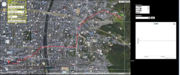
As this system is assumed to be used repeatedly, it is necessary for the system to be able to change and set the simulation conditions easily. Evacuation routes can be simulated on the map by entering the basic information, such as starting point, emergency evacuation spaces, eventual evacuation shelter, and number of evacuees. Fig. 2 and Fig. 3 utilize screenshots to explain the functions and usage of the system, as follows. Fig. 3 is the enlarged figure of the part 1 in the Fig.2.
Fig.2. System main screen
Fig.3. Evacuation guidance method input screen 1. Evacuation guidance method input space: The user enters
basic information such as starting point, eventual evacuation shelter and number of evacuees.
2. Simulation display space: This space shows the evacuation route and evacuation behavior visually.
3. Enter starting point: The user chooses the starting point for the tourists’ evacuation from a drop-down menu.
4. Enter emergency evacuation spaces: The user chooses the emergency evacuation spaces from the list.
5. Enter destination: The user chooses the destination for the tourists’ evacuation from a drop-down menu.
6. Enter number of tourists: The user enters the number of tourists who are at the starting point.
7. Register evacuation guidance method: The user registers the evacuation guidance method from origin to destination with this button.
8. Simulation start button: The system starts the simulation for the registered evacuation guidance method with this button.
9. Set standby time: The user sets the standby time that the tourists spend at the emergency evacuation spaces.
C. Implementation of phased evacuation guidance method
This system can set multiple starting points, the eventual destination, and multiple emergency evacuation spaces (Fig.
4). It can also set the amount of time spent at the emergency evacuation spaces.
Fig. 4 shows setting of the emergency evacuation space at Maruyama Park, in an evacuation route from Kiyomizu Temple to Kyoto station. Fig. 5 shows the process of simulation when no emergency evacuation spaces are set between Kiyomizu Temple and Kyoto Station. Initially, the route from the starting point to the destination is set to the shortest path between them computed by Google Maps API.
But the user can change the route by drags intuitively.
Fig.4. Emergency evacuation space (Maruyama Park)
Fig.5. No emergency evacuation spaces
D. Visualization of the number of tourist evacuees Our previous system aggregated the number of evacuees as data when the evacuees arrived at the destination. However, it was not able to visually indicate how many people are contained at the destination. In actual evacuation guidance, the evacuees may overflow around the road and the station because the facilities and the open space have a limited capacity.
Therefore, using a dynamic graph which updates the number of evacuees every minute, the improved system can express the number of the evacuees in the space visually. This system visualized the number of the evacuees targeting JR Kyoto Station, which is the main station in Kyoto and located in the center of the sightseeing spot.
The graph is displayed on the right side of the screen in Fig.
6. It expresses the number of evacuees who arrive at JR Kyoto Station in each unit of time using a bar graph.
Fig.6. Visualization of the number of evacuees in Kyoto Station
E. Crowd walking speed
This section explains the walking speed when the crowd advances unidirectionally. The speed of the walkers is distributed over a wide range if there is no friction caused by congestion, obstacles, etc. However, the walking speed of the crowd maintains the same speed as the density rises. Togawa expresses the relationship between crowd density and walking speed as shown in Expression (1) [8].
V ( ρ ) = 66 ρ-0.7954, (1) where V is the walking speed (m/min) of the crowd and ρ is the crowd density (#people/m2) in a space.
As density rises, the walkers advancing in one direction walk in a line. The crowd density and the walking speed are stable, because the walkers preserve constant personal space.
This personal space is the physical distance beyond which walkers feel uncomfortable when others approach. The personal space changes depending on personal relationships and the environment in the crowd [9].
This system adopts a walking speed that basically follows the principle of Expression (1). A future task is to consider the conditions that influence the personal space of the tourist evacuees.
V. SYSTEM EVALUATION
We showed a usage example of this system to four personnel from the Disaster and Crisis Management Office of Kyoto in order to inspect the effectiveness of the system in January 2014. Three members of the Disaster and Crisis Management Office of Kyoto actually used the system. They were given the evacuation settings, and input them to our system. Table 2 shows the evacuation settings used during the evaluation of this system. Subsequently, we conducted an evaluation questionnaire and interview.
TABLE Ⅱ Evacuation settings
The evacuation guidance guides the tourists from Toji Temple to Kyoto Station. At the same time, tourists are guided from Kiyomizu Temple to Kyoto Station through Maruyama Park, which is an emergency evacuation space.
There are 10,000 tourists in each sightseeing spot.
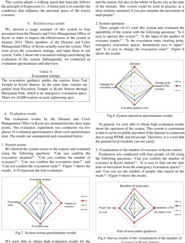
A. Evaluation results
The evaluation results by the Disaster and Crisis Management Office in Kyoto are summarized into three main points. The evaluation experiment was conducted via five phases of evaluation questionnaires about each questionnaire item. The results are summarized and considered below.
1. System screen
We showed the system screen to the experts and evaluated using the following questions: “Can you confirm the evacuation situation?”, “Can you confirm the number of evacuees?”, “Can you confirm the evacuation time?”, and
“Can you confirm the evacuation route?”. Figure 7 shows the results. A~D represent the four evaluators.
Fig.7. System screen questionnaire results
We were able to obtain high evaluation results for the evacuation situation, the evacuation route and evacuation time on the system screen. As these three factors can be confirmed using the system screen, we can consider that this system was able to show effectiveness as a wide-area evacuation simulator. On the other hand, we received the opinion that “there are people not only in sightseeing spots
and the station, but also in the whole of Kyoto city at the time of the disaster. This system could be used in practice as a more realistic simulator if you also simulate the movement of such people”.
2. System operation
Three people (A~C) used this system and evaluated the operability of the system with the following questions: "Is it easy to operate this system?", "Is the input of the number of evacuees simple?", "Is the evacuation route (starting point, emergency evacuation spaces, destination) easy to input?"
and "Is it easy to change the evacuation route?". Figure 8 shows the results.
Fig.8. System operation questionnaire results
In general, we were able to obtain high evaluation results about the operation of the system. This system is convenient in that it can be available anywhere if the Internet is connected, due to using HTML and Javascript. Therefore, it is a tool that the general local residents can use easily.
3. Visualization of the number of evacuees in Kyoto station Evaluation was conducted with four people (A~D) using the following questions: "Can you confirm the number of evacuees in Kyoto station?", "Is it easy to find out the start time of movement from the emergency evacuation spaces? ", and "Can you see the number of people who stayed on the roads?". Figure 9 shows the results.
Fig.9. Survey results of the visualization of the number of evacuees in Kyoto station
We were able to obtain good evaluation results about the examination of the evacuation route and the confirmation of the number of people. However, the evaluators pointed out that improvement of the graph showing the people who stayed
on the roads and the movement starting time was needed. For example, it was suggested that this system could express people who stay in one place by stopping the crowd when the evacuees cannot enter the open space. Also, it was suggested that this system could change the color of the graph if the evacuees cannot enter the space anymore.
VI. FUTURE OUTLOOK
Many functions were observed that should be added to this system as a wide-area evacuation simulator. In future, we will add these functions and will develop a more practical evaluation tool for wide-area evacuation guidance methods.
The following is a summary of the contents which should be added to the system.
Targeting various people within Kyoto city in the simulation.
Considering people who do not follow the evacuation guidance.
Proposing evacuation guidance routes through the simulation.
Displaying the stopping status of the crowd for the whole area.
Elaborating the crowd confluence model.
REFERENCES
[1] Niigata Prefecture Industrial Tourism Department, Tourist Bureau, Interchange Planning Division: Summary of changes in Niigata sightseeing, October 2009. (In Japanese)
[2] Tokyo Metropolitan Government Bureau of Industrial and Labor Affairs, Tourism Department, Planning Division: Factual investigation into the number of the tourists in Tokyo in 2011. July 18, 2012. (In Japanese)
[3] Kyoto Shimbun: Kyoto-Shiga economy this year (3) for sightseeing.
November 23, 2011. (In Japanese)
[4] Kyoto City Industrial Tourist Bureau: Kyoto city sightseeing investigation annual report, 2009. (In Japanese)
[5] Yoshio Nakatani, A verification and research report on collecting and making assistance information available on tourist’s disaster prevention, March, 2011, pp.62-66. (In Japanese)
[6] Kyoto Navi, Guidance of emergency evacuation spaces for tourist, http://www.kyoto-navi.com/content/hinan/, (Dec. 05, 2014) [7] Seiki Kinugasa, Tomoko Izumi, Yoshio Nakatani: Evaluation of a
Support System for Large Area Tourist Evacuation Guidance: Kyoto Simulation Results, in Proceedings on the 8th International Conference on Geo-information for Disaster Management (Gi4DM), pp. 67-78, Dec. 2012.
[8] Kikuji Togawa: Study of the evacuation facilities based on the observation of the crowd, 1963. (In Japanese)
[9] Dirk Helbing, Peter Molnar, Illes J Farkas and Kai Bolay:
Self-organizing pedestrian movement, Environment and Planning B:
Planning and Design, Vol.28, pp.361-383, 2001.