www.nat-hazards-earth-syst-sci.net/10/1635/2010/ doi:10.5194/nhess-10-1635-2010
© Author(s) 2010. CC Attribution 3.0 License.
and Earth
System Sciences
Description and analysis of the debris flows occurred during 2008
in the Eastern Pyrenees
M. Portilla1,2, G. Chevalier1,3, and M. H ¨urlimann1
1Department of Geotechnical Engineering and Geosciences, Technical University of Catalonia, Barcelona, Spain 2Geosciences Department – Faculty of Sciences, National University of Colombia, Bogot´a, Colombia
3Sediment Transport Research Group, Technical University of Catalonia, Catalonia, Barcelona
Received: 4 November 2009 – Revised: 26 April 2010 – Accepted: 12 May 2010 – Published: 30 July 2010
Abstract. Rainfall-triggered landslides taking place in the Spanish Eastern Pyrenees have usually been analysed on a regional scale. Most research focussed either on terrain sus-ceptibility or on the characteristics of the critical rainfall, ne-glecting a detailed analysis of individual events. In contrast to other mountainous regions, research on debris flow has only been performed marginally and associated hazard has mostly been neglected.
In this study, five debris flows, which occurred in 2008, are selected; and site specific descriptions and analysis re-garding geology, morphology, rainfall data and runout were performed. The results are compared with worldwide data and some conclusions on hazard assessment are presented.
The five events can be divided into two in-channel de-bris flows and three landslide-triggered dede-bris flows. The in-channel generated debris flows exceeded 10 000 m3, which are unusually large mass movements compared to historic events which occurred in the Eastern Pyrenees. In contrast, the other events mobilised total volumes less than 2000 m3. The geomorphologic analysis showed that the studied events emphasize similar patterns when compared to published data focussing on slope angle in the initiation zone or catchment area.
Rainfall data revealed that all debris flows were triggered by high intensity-short duration rainstorms during the sum-mer season. Unfortunately, existing rainfall thresholds in the Eastern Pyrenees consider long-lasting rainfall, usually oc-curring in autumn/winter. Therefore, new thresholds should be established taking into account the rainfall peak intensity in mm/h, which seems to be a much more relevant factor for summer than the event’s total precipitation.
Correspondence to: M. Portilla ([email protected])
The runout analysis of the 2008 debris flows confirms the trend that larger volumes generally induce higher mobility. The numerical simulation of the Riu Runer event shows that its dynamic behaviour is well represented by Voellmy fluid rheology. A maximum front velocity of 7 m/s was back-analysed for the transit section and even on the fan velocities larger than 2 m/s were obtained.
This preliminary analysis of the major Eastern Pyrenean debris flows represents the first background for future stud-ies. Additional research on other events is necessary to sup-port the results presented herein, and to properly assess and reduce hazard related to debris flows.
1 Introduction
In the Eastern Pyrenees, shallow landslides and debris flows are not as widely reported as in other mountainous catch-ments. However, they represent an important hazard that should be assessed. Until now, most of the descriptions or analyses focus on shallow landslides and have been carried out at regional scale, applying geographical information sys-tem (GIS) techniques (e.g. Baeza and Corominas, 2001; San-tacana et al., 2003), inventory data (Gallart and Clotet, 1988) or other types of models (Bathurst et al., 2006). Addition-ally, the majority of these studies focuses on failures trig-gered during the catastrophic 1982 rainstorm. All this shows the lack of information and research on debris-flow initiation, flow behaviour and hazard in the Eastern Pyrenees. Only in the Principality of Andorra some analysis on debris-flow hazards has been carried out for urban planning purposes (H¨urlimann et al., 2006).
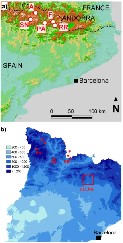
Figure 1: a) L ocation of the five debris flowean annual precipitation (in ms, b) Mm) of Catalonia (Source: CAC). (A: Andreuet, F: Fontanals del Pui, PA. Portainé, RN: Sant N: Runer, Siu RRicolau, ULLRB: Upper Llobregat River Basin)
Figure 1: a) Location of the five debris flows, b) Mean annual precipitation (in mm) of Catalonia (Source: CAC). (A: Andreuet, F: Fontanals del Pui, PAiu R: RR. Portainé, Runer, SN: Sant Nicolau, ULLRB: Upper Llobregat River Basin)
Fig. 1. (a) Location of the five debris flows, (b) Mean annual precipitation (in mm) of Catalonia (Source: CAC, Climatic Atlas of Catalonia, http://www.meteocat.com/mediamb xemec/servmet/, last access: 8 October 2009). (A: Andreuet, F: Fontanals del Pui, PA: Portain´e, RR: Riu Runer, SN: Sant Nicolau, ULLRB: Upper Llobregat River Basin.)
flows were selected due to data availability (Fig. 1a). More-over, all events involve a volume which is likely to produce damage on the fan area. The terminology of the process type used in this paper is in accordance with that of Hungr et al. (2001), while the distinction between in-channel gen-erated debris flows and landslide triggered debris flow was applied as proposed by Coussot and Meunier (1996).
The main purpose of this study is the description and anal-ysis of the most important parameters for hazard assessment of the selected events. First, the susceptibility, or geologic and morphologic conditions, are revised. Second, the trigger
mechanism, which is intense rainfall, is analysed. And third, the runout, together with the dynamic behaviour of the mass movements, is studied. Additionally, the results are com-pared with events that occurred at other sites of the world in order to evaluate site-specific characteristics. Finally, the re-sults of this research could support future studies and may furnish practitioners and stakeholders with important infor-mation to improve protection and to mitigate such hazards.
2 General settings
The Pyrenees are a mountain range that represents the natural boundary between France and Spain and enclaves the Prin-cipality of Andorra. It spreads on shore over 430 km on an East-West axis. The study area belongs to the Eastern Pyre-nees.
The Pyrenees are old and young at the same time. Young because the uplift of the range started 40 millions years ago, and old because the material uplifted did not form at that time, but long before that (Mu˜noz, 1992; Teixell, 1998; ICC, 2003).
All our events occurred in the Axial Pyrenees, which are comprehensively described by ECORS Pyrenees Team (1988). The stratigraphy of our study area runs from Ordovician to Devonian with Tardi-Hercynian intrusions. The network of faulting is dense and complex, roughly fol-lowing an ENE-WSW axis, but reported as showing little activity when compared to other ranges’ exhumation rates (Fitzgerald et al., 1999; Lynn, 2005).
During the Pleistocene, the Axial Pyrenees were covered by glaciers and their great power of erosion formed cirques and U-shaped valleys. As a matter of fact, bedrock and tills are the most common outcrops in the study area. Not to be forgotten is the presence of colluviums, sometimes covering the mentioned units, thus, creating a discontinuous sequence of deposition.
The complex meteorology of the study area is due to its ge-ographical position between the Mediterranean Sea and the Atlantic Ocean, as well as between continental and oceanic huge extensions. Moreover, its latitudinal situation inside a temperate climate zone leads to seasonal extreme variations (Cuadrat and Pita, 1997; Mart´ın and Olcina, 2001; Servei Meteorol`ogic de Catalunya1). For these reasons, the summer season is dry and the rest of the year is moderately humid, the highest precipitation being in autumn.
The relief of the field site ranges from sea level to over 3400 m above sea level (a.s.l.) (Aneto Peak). A high relief combined with prevailing winds, yields to weather contrasts as observed in the average annual rainfall (Fig. 1b). Pre-cipitation can range from 850 to 1200 mm/year in the catch-ments, where the debris flows in 2008 took place.
Table 1. Geomorphological parameters assessed by field work (volumes), topographic maps, aerial pictures, and archives. For Riu Runer and Portain´e, maximum elevations correspond to the catchment’s maximum elevation. For the others, maximum elevations refer to the landslide crown zone. The minimum elevation is always for the elevation of the fan’s apex.
Riu Runer Fontanals del Pui Portain´e Andreuet Sant Nicolau
Volume (m3) 14 000 1500 26 000 1000 1800
Catchment area (km2) 8.2 0.2 5.5 0.029 0.26
Catchment exposure W ESE N S S
Maximum/minimum elevation (m a.s.l.) 2150/885 1240/950 2400/975 1975/1550 1985/1480
Mean slope angle of fan (◦) 11 13 9 10 10
Mean slope angle of channel (◦) 13 37 16 32 35
Runout,L(m) 5175 710 4400 890 995
Vertical drop,H (m) 1154 290 1155 425 505
H /L(–) 0.22 0.41 0.26 0.48 0.51
Melton ratio 0.45 0.67 0.61 2.91 0.98
3 Event descriptions
This section accounts for an interdisciplinary description of the investigated events. Geology, morphology, hydrology, el-ements at risk, process description and damages are reported. This part focuses first on in-channel debris flows. Then land-slide triggered debris flows are tackled. Data used in this part are presented in Table 1, which were gathered through the study of aerial pictures and topographic map, as well as archives like newspapers or administrative reports and field work.
3.1 In-channel generated debris flows 3.1.1 Riu Runer
The Riu Runer catchment is located at the border of Spain and the Principality of Andorra (Fig. 1a) and drains a total area of 8.2 km2 (Fig. 2a). The bedrock in this area dates from Silurian and consists of slate (ICC, 2003). Most of the catchment area is overtopped by colluvial and fluvial glacial deposits.
The catchment is a place of pasture (upper part) and forest (lower/middle part) with little signs of human activity. The profile of the torrent’s slope can be found in Fig. 3. Along its channel, only a few past lateral contributions of material (shallow landslides and/or banks destabilization) were ob-served.
On the evening of 1 August 2008, the Andorran Border Customs house was severely hit by a debris flow triggered by a short and intense thunderstorm. This debris flow seemed to be the result of the progressive incorporation of bed material within the channel due to a high discharge, since no traces of landslides are visible in the initiation area. The torrent in the upper reach (down to 2000 m a.s.l.; see Fig. 3) shows signs of moderate fluvial erosion (V-shaped channel erosion) and some deposition (small areas of accumulation of loose
mate-Figure 2: Catchment maps of Riu Runer (a) and Portainé (b). The river courses are drawn wider than the torrents and both in light blue, in red depositional areas, and in grey the catchment surface. Contour intervals are every 50 meters.
(a)
(b)
Fig. 2. Catchment maps of Riu Runer (a) and Portain´e (b). The river courses are drawn wider than the torrents and both in light blue, in red depositional areas, and in grey the catchment surface. Contour intervals are every 50 m.
0 500 1000 Distance (m)
800 1200 1600 2000
Ele
vat
ion (m asl
)
0 2000 4000 6000
Distance (m) 800
1200 1600 2000 2400
Ele
vation
(
m
as
l)
Initiation zone
Apex
0 2000 4000 6000
Distance (m) 2400
l)
as 2000
m
(
ation
1600
v 1200
Ele
800 (c)
Vertical exaggeration of 4 times
Legend Portainé Riu Runer Andreuet Fontanals Sant Nicolau Maximum runout
Apex
Vertical exaggeration of 2 times Vertical exaggeration null
(a)
(b)
Figure 3: Topographic profiles of a) the landslide triggered debris flows (profiles start at the landslide’s headscar), b) the in-channel generated debris flows and c) both sorts of debris flows.
Fig. 3. Topographic profiles of (a) the landslide triggered debris flows (profiles start at the landslide’s headscar), (b) the in-channel generated debris flows, and (c) both sorts of debris flows.
The deposit area starts just a couple of hundred metres upstream of the Andorran Border Customs house at the fan apex (900 m a.s.l.). Eventually the torrent channel could not drain the flow discharge; a culvert was obstructed, block-ing the flow and forcblock-ing both material and trees to depose. The consequence was the accumulation of material partly
burying buildings and cars present on site. The water sup-ply in the near proximity was also disturbed, as two aque-ducts present in the channel were destroyed. Fortunately no casualties were reported.
An estimate of the scoured material quantity, as well as contributions along the debris flow path, was carried out and cross-checked with the total volume of material deposited at the fan, which was estimated on field. Finally, the to-tal volume of the debris flow was assumed to be 14 000 m3 (Table 1).
3.1.2 Portain´e
In the Portain´e ski resort area, bedrock is the oldest outcrop-ping in the Pyrenees, Cambrian to Ordovician in age (ICC, 2003), and consisting of sedimentary units made of pelite, sandstone and greywacke. To some extent colluviums and fluvio-glacial deposits overtop them.
The catchment consists of two main torrents, the Portain´e torrent in the West and the Reguerals torrent in the East (Fig. 2b). The morphology of the basin can be divided into two parts: a smooth higher part, where the presence of rills can be observed; and a steep lower part, where well incised channels were formed (Fig. 3). In the steep section, the flanks of the torrents are unstable and lateral failures due to erosion of the slope’s toe are recurrent but small (about several tens of cubic metres).
On the evening of 12 September 2008, a rainstorm hit the area and triggered one of the largest debris flows that took place in the Eastern Pyrenees. No clear initiation failure could be observed, thus, promoting the idea that the flow probably started by minor erosion along rills in the higher parts and transformed into a mature debris flow in the subse-quent steep section of the torrent, where scouring rates of up to∼10 m3/m led the bedrock to outcrop in some portions and the amount of material transported to considerably increase. Several secondary failures of adjacent slopes were also ob-served, which enlarged the total volume of the debris flow. Although the access road to the ski resort crosses the torrent in three distinct points and even though material deposition occurred at those points, as well as excessive failure of the road foundation, the main volume of the debris flow was de-posited at the fan. Note the presence on the fan of an electric plant, including a dam and a retention lake, which was only marginally hit by the debris flow.
The Portain´e’s debris flow seems to have been affected by the presence of the previously cited structures related to hu-man activity in the catchment. But the opposite is also true: 1) the ski resort faced profound reshaping of the surface, 2) roads were severely damaged, and 3) the electric plant facil-ities were superficially covered by an important volume of material.
3.2 Landslide triggered debris flows 3.2.1 Fontanals del Pui
Fontanals del Pui torrent is located in Andorra (Fig. 1a). The lithology of the site consists of Silurian slate and Quaternary slope debris, similar to the ones in Riu Runer catchment. However, a difference should be pointed out since no glacial features were exhibited. The vegetation on this slope is al-most absent. There are only patches of shrubs in the scree.
The rainfall that triggered the Riu Runer’s debris flow event had also consequences on the close neighbourhood. Some 5 km northward this rainfall induced the Fontanals del Pui event. This debris flow was triggered by a small fail-ure of the scree in the middle of the catchment. The transit path downstream of this initiation point shows an alterna-tion of erosion and no scouring (accumulaalterna-tion), which, due to the fact that trees had been bent and partially covered by fine sediments, suffered the action of the flow. As the flow crossed the road at the down part of the flow path, a first de-position area developed. There was still another area more downstream, where the same road is crossed again. The ar-tificial channel downstream this point was mostly filled by sediments. The particle size mobilised by the debris flow was smaller than in the Riu Runer including mainly gravels and boulders no bigger than 50–70 cm across. Given the small magnitude of the debris flow (∼1500 m3), the urbanised area developed on the fan did not suffer important damages. 3.2.2 Andreuet torrent
In Andreuet’s catchment (Fig. 1a), only metamorphic rocks made of slate and phyllite outcrop. They are covered, in the lower part, by colluvial material of metamorphic origin. Clay and gravels make up its grain size. The upper part of the catchment displays bushes and grass, while the lower part consists in trees and shrubs.
During the night, between 25 and 26 June 2008, a rain-storm induced a shallow landslide in the upper part of the catchment that developed into a debris flow. This flow began its erosional process when it reached the colluvium at mid-length and deposited as soon as it hit the road present at the slope’s toe. Within the torrent, lateral levees were observed and related to the last event.
3.2.3 Sant Nicolau
Sant Nicolau torrent is located close to the National Park in the Axial Pyrenees (Fig. 1a). Granitic rocks constitute the lithology outcropping in the catchment and are covered by colluvial material in the lower part of the catchment. Collu-vium thickness is of a couple of metres in the fan area and increases to a few metres as it reaches the contact with the bedrock. Regarding the grain size of the colluvium, metre-sized boulders supported by a sandy matrix can be observed in the upper part of the torrent. At the lower part, boulders become gravels of a few tens of centimetres in general. The morphology of the torrent should be noted as it displays a straight, stretched and elongated path. The vegetation con-sists of bushes and grass in the upper part of the catchment and presents in the lower part, small trees and shrubs.
On 25–26 May 2008, a shallow landslide induced by heavy rainfall provoked a debris flow in the Sant Nicolau tor-rent. The flow propagated down the steep upper part (Fig. 3), without significant erosion or deposition. At the bedrock-colluvium contact, a major scouring was observed. Within the colluvium the flow was confined in the torrent and lateral levees were formed. The flow blocked the access road of the National Park and deposited most material on the fan.
4 Morphologic analysis
The literature provides examples of geomorphological char-acterisation of debris flows (e.g. Di Crescenzo and Santo, 2005). However, only very few focus on the Eastern Pyre-nees (Gallart and Clotet, 1988; Corominas et al., 2002). That is why we have analysed two aspects of the five events de-scribed herein: one at catchment scale and the other fo-cussing on the initiation area.
At catchment scale, magnitude (total volume) and area were assessed for each event based on field work, aerial pic-tures and topographical maps. Figure 4a displays their rela-tionship. Limits published by D’Agostino and Marchi (2001) were added. They defined these limits using data on debris flows from 130 catchments observed in the Eastern part of the Italian Alps.
Then we propose the study of the initiation zone (Fig. 4b). In order to do so, the initiation point is defined, while two cases are recognised:
– When the debris flow originated from a landslide, the initiation point was chosen as the headscar.
0.01 0.1 1 10 Catchment area (km2)
100 1000 10000 100000 1000000
Vo
lu
me (
m
3)
Andreuet
Fontanals
Sant Nicolau Riu Runer Portainé Limits published by
D'Agostino and Marchi (2001) 2008 events
a)
0.001 0.01 0.1 1 10
Catchment area above initiation zone (km2) 0
10 20 30 40 50
Slop
e (
d
eg
rees
)
Fontanals
Sant Nicolau Andreuet
Portainé
Riu Runer Channel erosion Slope instability b)
0
1
2
3
4
Relative relief (-)
0
5
10
15
20
25
Slop
e
of th
e
fa
n (
deg
ree
) 2008 events
Bardou (2002)
Portainé
Andreuet RR FontanalsSN
Fluvial flows
Mixed flows Debris flows c)
Figure 4: G
eom
orphological relationships: a) volum
e versus catchm
ent area, b) slope versus catchm
ent area above initiation zone – C
hannel erosion and slope instability’s clusters follow
V
A
W
(1992) and Z
im
m
erm
ann et al. (1997), and c) slope of the fan versus relative relief (M
elton, 1965).
Fig. 4. Geomorphological relationships: (a) volume versus catchment area, (b) slope versus catchcatchment area above initiation zone -Channel erosion and slope instability clusters follow VAW (1992) and Zimmermann et al. (1997), and (c) slope of the fan versus rela-tive relief (Melton, 1965).
Figure 4a shows a positive trend: the magnitude of de-bris flows increases at the same time as the catchment area. Moreover, it appears that all the events described in this study fit within the limits published by D’Agostino and Marchi (2001). It may seem that the geographical position of the catchment does not quantitatively influence volume versus catchment area relationship. Nevertheless, further in-vestigation is needed to confirm this regional relationship
be-cause of the large scatter of data. The hazard study of Pyre-nean catchments could be greatly enhanced by the use of such a relationship. The determination of a catchment area could lead to a range in the preliminary estimation of the event’s magnitude, and could pledge for an optimised miti-gation.
When the slope at the initiation is plotted against the catchment area above this initiation zone, a negative corre-lation seems to emerge. VAW (1992) and Zimmermann et al. (1997) worked on this correlation for debris flows in the Swiss Alps, and defined and published two clusters of points shown in Fig. 4b. The first cluster gathers the events initiated by a slope failure. It lies at a small catchment area above the initiation zone (<0.1 km2) and at a rather large slope angle (over 27◦). A second cluster is emphasized and includes both in-channel formed debris flows. Although overlapping, the clusters shown in Fig. 4b incorporate all described events. Only the Andreuet position remains ambiguous because it belongs to both clusters.
The difference in elevation of a catchment divided by the square root of its area was firstly mentioned by Melton (1965), and is referred to as the relative relief. Differ-ent authors have used it since, emphasizing the relationship between the catchment morphology and the characterisation of the process building up the fan (Jackson et al., 1987; Bro-chot and Marchi, 2000; Bardou, 2002). Here, we proposed the study of the relationship between the relative relief and the slope of the fan (Fig. 4c) in order to analyse, if both those factors were consistent in differentiating fluvial from debris flow fans (Kostaschuk et al., 1986). Limits found in Bardou (2002) are depicted. Catchments and fan, where the 2008 debris flows occurred, are shown in relation to these limits. It appears that only Andreuet catchment and fan fit within the debris flow zone that Bardou (2002) introduced; the other four are to be found in the mixed zone. The French Alps (Maurienne region) served as a base for the establish-ment of Bardou’s limits, which have been edited comparing his Swiss dataset (Valais region) with that of Brochot and Marchi (2000). Undoubtedly limits have to be adapted for the Eastern Pyrenees.
All these results also show that the geomorphological study of catchments and of fans is not sufficient when inves-tigating debris-flow impact on the landscape. Many parame-ters, regarding land use, geology, the occurrence of wild fires, for instance, should also be considered (Liu at al., 2002; Di Crescenzo and Santo, 2005).
5 Rainfall analysis
Table 2. Information on meteorological stations and rainfall characteristics.
Riu Runer Fontanals del Pui Portain´e Andreuet Sant Nicolau
Meteorological station Sant Juli`a de L`oria Aix`as Sal`oria Bonaigua Boi
Recording interval 6 min 10 min 1 h 30 min 1 h
Altitude (m a.s.l.) 865 1566 2445 2266 2540
Distance to debris flow source area (km) 5.4 2.1 17.0 4.0 9.4
Mean annual rainfall (mm) 850–900 850–900 950–1000 1150–1200 1000–1050
Total rainfall for debris flow trigger (mm) 64.4 31.5 40.7 40.0 30.9
Duration rainfall (h) 3.3 4.5 6.5 9.0 7.0
Rainfall peak intensity (mm/h) 57.0 29.9 14.6 13.6 13.0
5.1 Previous studies
Few rainfall thresholds for landslide occurrence on the south face of the Eastern Pyrenees can be found in literature. The following three studies have focussed on the upper Llobregat River Basin (Fig. 1b) and represent the most relevant back-ground for the analysis of the five 2008 debris flows.
Corominas and Moya (1999) stated that debris flows and shallow slides in colluvial material and weathered rocks are initiated by a minimum of 190 mm of rainfall in 24 h, re-gardless of the antecedent rainfall. Another condition was defined by the total rainfall amount exceeding 300 mm in 24–48 h. Regarding reactivations of mudslides and slides in clayey materials, they propose a rainfall amount of 40 mm in 24 h and 200 mm of antecedent precipitation.
Corominas et al. (2002) suggested the expression Id=66.1Dd−0.59 as a rainfall threshold for reactivation of mudslides and mid-sized slides (whereIdstands for the rain-fall intensity in mm/day and Dd is the rainfall duration in days).
Marco (2007) defined the critical rainfall for different types of mass movements (principally slides, debris flows and earth flows) as 51 mm in 24 h with the requirement of about 61 mm of antecedent rainfall. The expression standing for this threshold is given by Ac>24Dw+109, in which Ac represents accumulated precipitation in millimetres andDw the rainfall duration in weeks.
An important drawback for the application of these thresh-olds to our five debris flows is the fact that all of the pro-posed relationships were established by studying daily rain-fall records. In addition, the rainrain-fall episodes occurred dur-ing autumn or winter seasons regarddur-ing long-lastdur-ing rainfalls with a duration of more than one day, which normally cover a large geographic area and result from advective storms. 5.2 Rainfall data analysis
The information on the rainfall data and meteorological sta-tions used in this study is listed in Table 2. The rainfall data recorded at the closest meteorological stations for every event were plotted in its respective hyetograph to find out their main characteristics and to get some insight into their
temporal behaviour. Note that no rainfall occurred during at least 8 days before the events under study took place. The only exception is Sant Nicolau, where 70.8 mm precipitation was measured during the 4 days previous to the debris flow. Another interesting fact is that the Riu Runer and Fontanals del Pui events, 8.5 km away from each other, were triggered by the same storm happening on 1 August 2008.
The hyetographs (Fig. 5) depict that for the Riu Runer and Fontanals del Pui events, the rainfall peak intensity is reached very quickly (less than 1 h) and subsequently the rainfall sud-denly ceases. For the Sant Nicolau and Andreuet events, the maximum rainfall intensity is reached slowly (during∼7 h) and then the rainfall terminates in less than 2 h. Meanwhile, for Portain´e debris flow, the maximum rainfall is reached in one and a half hours, and rainfall decreases as time goes by (6 h).
The five rainfall records can be summarised by two sim-ple statements: 1) the hourly peak intensities range from 13 to 57 mm/h; and 2) the total rainfall amounts are be-tween 31 and 64 mm. Interpreting this information, several well-known limitations related to the analysis of landslide-triggering rainfalls should be considered such as site-specific meteorological and hydrological conditions or the distance between the debris-flow event and the rain gauge (Crosta, 1998; Aleotti, 2004; Guzzetti et al., 2007). Nevertheless, a preliminary hypothesis seems to be that the five debris flows studied herein were triggered by short and intense rain-storms. However, the role played by the antecedent rainfall should never be disregarded, like it happened in Sant Nicolau event.
5.3 Comparison with rainfall thresholds
The main annual rainfall of the different areas investigated ranges from 850 to 1200 mm (Table 2). The mean rain-fall intensity – duration curves of the five debris flows were compared with two types of published thresholds: regional (Guzzetti et al., 2007) and the ones for the Eastern Pyrenees (Corominas and Moya, 1999; Corominas et al., 2002; Marco, 2007).
0 1 2 3 4 5 6 7 8 9 Time (h)
0 10 20 30 40 50 60 70
C
u
m
u
la
tiv
e r
ai
nf
all
(m
m
)
0 1 2 3 4 5 6 7 8 9
Time (h) 0
2 4 6 8 10 12 14 16
P
re
ci
pitati
on (mm
)
Andreuet Sant Nicolau Fontanals del Pui
Port Ainé Riu Runer
? ?
(a) (b)
Figure 5: Hyetographs (a) and cumulative rainfalls (b) of the debris flows studied. Arrows indicate an estimated debris flow time of occurrence. A question mark accompanies the arrow when this estimate relies on doubt.
Fig. 5. Hyetographs (a) and cumulative rainfalls (b) of the debris flows studied. Arrows indicate an estimated debris flow time of occurrence. A question mark accompanies the arrow when this estimate relies on doubt.
0.1 1 10
Duration (h)
1 10 100
Me
an
rai
nf
a
ll i
n
te
ns
ity
(
m
m
/h
)
Puerto Rico China Brazil Japan Switzerland Taiwan Italy
RR
F
A PA
SN
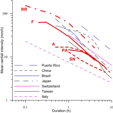
Figure 6: Comparison between rainfall intensity-duration curves of the five debris flows analysed and regional scale thresholds (Guzzetti et al, 2007).
Fig. 6. Comparison between rainfall intensity-duration curves of the five debris flows analysed and regional scale thresholds (Guzzetti et al., 2007).
evolution, the Riu Runer debris flow fits almost all the rela-tionships. In contrast, the other events remain unpredictable by most relationships.
Regarding the thresholds defined for the Eastern Pyrenees, Corominas and Moya’s (1999) threshold does not fit the five debris flows studied, because the total rainfall amount for each one was less than 190 mm. Likewise Marco’s (2007) threshold does not match, because neither the event rainfall nor antecedent rainfall were reached. Finally, the published threshold of Corominas et al. (2002) could not apply to our study because it was obtained for long-lasting rainfalls (more than 24 h); the events studied in this paper were caused by short duration storms (less than 10 h).
In a nutshell and according to the previous results and analyses, it can be assumed that the 2008 debris flows were triggered by short duration-high intensity rainfalls, all of
them happening during the summer season. Consequently, they do not fit the existing thresholds established for the Eastern Pyrenees. Thus, it is necessary to establish new thresholds related to convective summer storms using at least hourly rainfall data. Such detailed rainfall records are essen-tial information in order to get appropriate critical rainfall characteristics that explain the triggering of debris flows as during the summer 2008.
6 Runout analysis
The runout analysis of the different events was carried out by applying two methodologies. First, the runout data of all events were compared with published empirical relation-ships. Then, one selected event was analysed more compre-hensively, applying numerical modelling in order to investi-gate its flow behaviour.
6.1 Empirical runout prediction
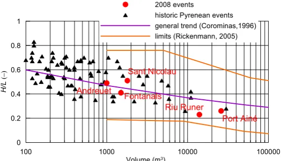
Empirical relationships are very common methods to approx-imate the maximum runout distance of debris flows and other types of mass movements. Here, we compare the mobility of the 2008 Pyrenean debris flows using the ratio between the vertical drop, H, and the horizontal projection of the total runout distance,L(e.g. Rickenmann, 1999). This ratioH /L can also be called reach angle,α, or “Fahrb¨oschung” and is linked to the debris-flow volume,V.
100 1000 10000 100000 Volume (m3)
0 0.2 0.4 0.6 0.8 1
H/
L
(−
)
2008 events
historic Pyrenean events general trend (Corominas,1996) limits (Rickenmann, 2005)
Riu Runer
Port Ainé Sant Nicolau
Andreuet
Fontanals
Figure 7: Mobility comparison of 2008 debris flows with other published data from the Eastern Pyrenees and worldwide records.
Fig. 7. Mobility comparison of 2008 debris flows with other published data from the Eastern Pyrenees and worldwide records.
0 500 1000 1500 2000 2500 3000 3500 4000 4500 5000 800
1000 1200 1400 1600 1800 2000 2200
El
eva
tio
n (
m
a.
s.
l.)
topographic profile channel width bed slope
0 5 10 15 20 25 30 35
C
ha
nnel w
idth
(m
)
Be
d s
lop
e
(
de
gre
e)
0 500 1000 1500 2000 2500 3000 3500 4000 4500 5000 Horizontal distance (m)
0 2 4 6 8 10
F
ro
nt ve
lo
cit
y
(m
/s
)
velocity area (simulated) area (field)
0 10 20 30 40 50
Max
im
um f
low area
(
m
2)
(a)
(b)
Figure 8: N um erical sim ulation results of the Runer event. a) Liu Rongitudinal profile, channel width and bed slope used in the simulation. b) R for C =NAesults obtained by D 10 m1/2/s and µ = 0.1, showing the variation of the front velocity and the maximum flow area. Squares represent cross-section areas.
Fig. 8. Numerical simulation results of the Riu Runer event. (a) Longitudinal profile, channel width and bed slope used in the simulation.
(b) Results obtained by DAN forC=10 m1/2/s andµ=0.1, showing the variation of the front velocity and the maximum flow area. Squares
represent cross-section areas.
limits of the data published in Rickenmann (2005) were also illustrated. The comparison of the 2008 debris flows with the data from other published events indicate, that: 1) the Riu Runer and Portain´e events are one of the largest debris flows that have recently been observed in the Eastern Pyrenees, 2) all five events are located in the mobility range defined by empirical relationships and published data.
6.2 Numerical simulation
The Riu Runer event was selected to carry out a detailed anal-ysis of the dynamic behaviour by numerical modelling. This back-analysis may lead to the answering of questions such
as: Can Pyrenean debris flows be simulated by similar rheo-logic models and parameter values like the ones from differ-ent mountain ranges? Which were the maximum velocities and discharges of the debris flow? Are they comparable to events from other mountain ranges?
The rheological law assumed in the model runs was the Voellmy fluid model. This decision is supported by the fact that recent back-analyses of Andorran debris flows have shown that the Voellmy fluid flow law provided reasonable results (H¨urlimann et al., 2006), and that the Voellmy fluid model is widely considered to be a suitable law for granu-lar debris flow (e.g. Naef et al., 2006). The two necessary parameters for this rheological model are dry friction coeffi-cient,µ, and turbulent Chezy-like friction term,C.
The sensitivity analysis of the two rheological parameters was performed for the following assumptions, which are nec-essary to simplify the real process for the simulations. An initial volume of 770 m3was released at an altitude of about 2000 m a.s.l., and then a constant entrainment rate of 4 m3/m was assumed, which produced a final volume at the fan of about 14 000 m3. The channel width upstream of the fan was defined by a constant value of 5 m and an increasing width up to 30 m in the accumulation area.
The sensitivity analysis of the two rheological parameters was performed comparing simulated values with field obser-vations of both the maximum runout distance and the flow ar-eas or inundated area. A common problem of two-parameter analysis represents the fact that various combinations of µ-and C-values are possible for reasonable matches of simula-tion results with field observasimula-tions. Finally, the best-fit sim-ulation results were obtained by aµ-value of 0.1 and a C-value of 10 m0.5/s. Figure 8 illustrates the front velocity and maximum flow area along the flow path and shows that the flow was rather slow in the upper smoother part, while veloc-ity increased up to 7 m/s in the steepest section. Maximum flow discharge in this section was about 55 m3/s, while flow discharge and velocity decreased to about 35 m3/s and 4 m/s, when entering the fan. In the accumulation area, the flow stopped and remobilised several times, which is represented by the fluctuations at the final section of the flow path.
The comparison of the values of the rheological parame-ters and the data acquired from the back-analyses of other Andorran events (H¨urlimann et al., 2006) shows that, in the case of the Runer River, the values of the dry friction coef-ficientµ are a bit smaller, while the C-value matches well with the rest of results. This fact may support the hypothesis of some eyewitnesses that indicate that high water content in the flow is likely to reduce the frictional component (EU-ROCONSULT ANDORRA S.A., personal communication, 2008). Nevertheless, both rheological parameters match the value ranges published in a recent review on debris flow pa-rameters (H¨urlimann et al., 2008). In addition, maximum flow velocity, flow area and discharge observed in the back-analysis coincide with the characteristics of events analysed in other studies (e.g. Rickenmann, 1999), although the max-imum discharge of the Runer River event was smaller than assumed for granular debris flows. This fact may again sup-port the hypothesis that the event may have included a higher liquid concentration.
7 Conclusions
Research on debris flow has only been performed marginally in the Pyrenees and associated hazard has been mostly ne-glected. That is why we proposed here the study of five de-bris flows, which occurred in 2008 in the Eastern Pyrenees. The susceptibility, trigger and dynamical behaviour represent the investigation’s scope.
Landslide triggered debris flows encountered in 2008 dis-play a high slope at the scar (over 25◦) and a little catch-ment area above the initiation zone (less than 0.1 km2) rela-tionship. In-channel generated debris flows, on the contrary, show a large catchment area above the initiation zone (close to 1 km2) and a lower slope angle (less than 15◦). There also seems to exist a positive correlation between catchment area and debris flow volume. The distinction of both debris-flow types is, however, hardly achievable when only taking into account simple geomorphological parameters such as rela-tive relief and the fan’s slope. Finally, the fact that data from the Eastern Pyrenees fit the relationships validated for the European Alps, tends to pledge for an interregional standard-ization of the susceptibility analysis of such hazards.
For the Eastern Pyrenees only thresholds, considering long-lasting rainfall usually occurring in autumn/winter, have been established. However, high intensity and short du-ration storms are involved here in the studied events. For this reason, the most relevant aspect to consider is the rainfall peak intensity (mm/h). Therefore, new thresholds regarding short duration convective storms must be defined using this study’s results as a starting point, as well as the role played by antecedent rainfall.
Riu Runer being a recent outstanding debris flow for the Eastern Pyrenees proved to be a good event for a 1-D sim-ulation. It appeared that the Voellmy fluid rheology fitted the flow behaviour. The maximum velocity obtained reaches 7 m/s and the maximum flow discharge was about 55 m3/s. Both are in a coherent range when compared to other debris flows presented in the literature.
The results are promising and widen the scope of applica-bility of relationships defined in the literature so far. More examples are, however, recommended to refine the results presented.
Acknowledgements. This research was supported by the Spanish
Ministry of Science and Innovation, contract CGL2008-00299/BTE and the EC FP7 project IMPRINTS, contract ENV-2008-1-226555. Rainfall data for Andorra was provided by EUROCONSULT ANDORRA SA and Andorran Civil Protection.
Edited by: M. Arai
References
Aleotti, P.: A warning system for rainfall-induced shallow failures, Eng. Geol., 73, 247–265, 2004
Baeza, C. and Corominas, J.: Assessment of shallow landslide sus-ceptibility by means of multivariate statistical techniques, Earth Surf. Proc. Land., 26, 1251–1263, 2001.
Bardou, E.: Methodologie de diagnostic des laves torrentiells sur un bassin versant, Ecole Polytechnique de Lausanne, th`ese doc-torale, 188 pp., 2002 (in French).
Bathurst, J. C., Burton, A., Clarke, B. G., and Gallart, F.: Appli-cation of the SHETRAN basin-scale, landslide sediment yield model to the Llobregat basin, Spanish Pyrenees, Hydrol. Pro-cess., 20, 3119–3138, 2006.
Brochot, S. and Marchi, L.: Les cˆones de d´ejection torrentiels dans les Alpes franc¸aises. Morphom´etrie et processus de transport solide torrentiel, Revue de g´eographie alpine, 88, 23–38, 2000 (in French).
Coussot, P. and Meunier, M.: Recognition, classification and me-chanical description of debris flows, Earth-Sci. Rev., 40, 209– 227, 1996.
Corominas, J.: The angle of reach as a mobility index for small and large landslides, Can. Geotech. J., 33(2), 260–271, 1996. Corominas, J. and Moya, J.: Reconstructing recent landslide
activ-ity in relation to rainfall in the Llobregat River basin, Eastern Pyrenees, Spain, Geomorphology, 30, 79–93, 1999.
Corominas, J., Moya, J., and H¨urlimann, M.: Landslide rainfall trig-gers in the Spanish Eastern Pyrenees, Editrice, Mediterranean Storms, Proceedings of the 4th EGS Plinius Conference held at Mallorca, Spain, 2002.
Crosta, G.: Regionalization of rainfall thresholds: an aid to land-slide hazard evaluation, Environ. Geol., 35, 131–145, 1998. Cuadrat, J. M. and Pita, M. F.: Climatolog´ıa. Ediciones C´atedra,
Madrid, Espa˜na, 496 pp., 1997.
D’Agostino, V. and Marchi, L.: Debris Flow Magnitude in the East-ern Italian Alps: Data Collection and Analysis, Phys. Chem. Earth Pt. C, 26(9), 657–663, 2001.
Di Crescenzo, G. and Santo, A.: Debris slides-rapid earth flows in the carbonate massifs of the Campania region (Southern Italy): morphological and morphometric data for evaluating triggering susceptibility, Geomorphology, 66, 255–276, 2005.
ECORS Pyrenees Team: The ECORS deep reflection seismic sur-vey across the Pyrenees, Nature, London, 331, 508–510, 1988 Fitzgerald, P. G., Mu˜noz, J. A., Coney, P. J., and Baldwin, S. L.:
Asymmetric exhumation across the Pyrenean orogen: implica-tions for the tectonic evolution of a collisional orogen, Earth Planet. Sc. Lett., 173(3), 157–170, 1999.
Gallart, F. and Clotet, N.: Some aspects of the geomorphic pro-cesses triggered by an extreme rainfall event: The November 1982 flood in The Eastern Pyrenees, Catena Supp., 13, 79–95, 1988.
Guzzetti, F., Peruccacci, S., Rossi, M., and Stark, C. P.: Rain-fall thresholds for the initiation of landslides in central and southern Europe, Meteorol. Atmos. Phys., 98(3–4) , 239–267, doi:10.1007/s00703-007-0262-7, 2007.
Hungr, O.: A model for the run-out analysis of rapid flow slides, de-bris flows, and avalanches, Can. Geotech. J., 32, 610–623, 1995. Hungr, O., Evans, S. G., Bovis, M. J., and Hutchinson, J. N.: A re-view of the classification of landslides of the flow type, Environ. Eng. Geosci., 3, 221–238, 2001.
H¨urlimann, M. and Baeza, C.: Analysis of debris-flow events in the eastern Pyrenees, Spain, 1st European Conference on Land-slides, Balkema, Prague, 213–220, 2002.
H¨urlimann, M., Copons, R., and Altimir, J.: Detailed debris flow hazard assessment in Andorra: A multidisciplinary approach, Geomorphology, 78, 359–372, 2006.
H¨urlimann, M., Rickenmann, D., Medina, V., and Bateman, A.: Evaluation of approaches to calculate debris-flows parameters for hazard assessment, Eng. Geol., 102, 152–163, 2008. ICC, Institut Cartogr`afic de Catalunya: Mapa geol`ogic de Catalunya
1:250 000, Barcelona, 2003.
Jackson, L. E., Kostaschuk, R. A., and MacDonald, G. M.: Iden-tification of debris flow hazard on alluvial fans in the Canadian rocky mountains, Eng. Geol., 7, 115–124, 1987.
Kostaschuk, R. A., MacDonald, G. M., and Putnam, P. E.: Deposi-tional process and alluvial fan-drainage basin morphometric re-lationships near Banff, Alberta, Canada, Earth Surf. Proc. Land., 11, 471–484, 1986.
Liu, X., Yue, Z. Q., Tham, L. G., and Lee, C. F.: Empirical assess-ment of debris flow risk on a regional scale in Yunnan Province, southwestern China, Environ. Manage., 30, 249–264, 2002. Lynn, G.: Macrogeomorphology and Erosional History of the
Post-Orogenic Pyrenean Mountain Belt, Ph.D. thesis, The University of Edinburgh, Edinburgh, 388 pp., 2005
Marco, P. L.: Determinaci´o de llindars de pluja desencadenants d’esllavisades a Catalunya, Tesina de Grau, Departament d’Enginyeria del Terreny, Cartogr`afica i Geof´ısica, Universitat Polit`ecnica de Catalunya, Barcelona, Espanya, 150 pp., 2007 (in Catalan).
Mart´ın, V. J. and Olcina, C. J.: Climas y Tiempos de Espa˜na, Alianza Editorial, S.A., Madrid, Espa˜na, 258 pp., 2001. Melton, M. A.: The morphologic and paleoclimatic significance of
alluvial deposits in southern Arizona, J. Geol., 73, 1–38, 1965. Mu˜noz, J. A.: Evolution of a continental collision belt:
ECORS-Pyrenees crustal balanced cross-section, in: Thrust Tectonics, edited by: McClay, K. R., Chapman and Hall, 235–246, 1992. Naef, D., Rickenmann, D., Rutschmann, P., and McArdell, B. W:
Comparison of flow resistance relations for debris flows using a one-dimensional finite element simulation model, Nat. Hazards Earth Syst. Sci., 6, 155–165, doi:10.5194/nhess-6-155-2006, 2006.
Rickenmann, D.: Empirical relationships for debris flows, Nat. Hazards, 19, 47–77, 1999.
Rickenmann, D.: Run-out prediction methods, in: Debris-flow Haz-ards and Related Phenomena, edited by: Jakob, M. and Hungr, O., Springer, Berlin, 305–324, 2005.
Santacana, N., Baeza, B., Corominas, J., Paz, A. D., and Mar-turi´a, J.: A GIS-Based Multivariate Statistical Analysis for Shal-low Landslide Susceptibility Mapping in La Pobla de Lillet Area (Eastern Pyrenees, Spain), Nat. Hazards, 30, 281–295, 2003. Teixell, A.: Crustal structure and orogenic material budget in the
west-central Pyrenees, Tectonics, 17, 395–406, 1998.
VAW: Murg¨ange 1987: Dokumentation und Analyse, in: Ver-suchsanstalt f¨ur Wasserbau, Hydrologie und Glaziologie (VAW), No. 97.6, ETH Z¨urich, unpublished, 620 pp., 1992.