Global Journal of Advanced Engineering Technologies and Sciences
NEW INDUCTIVE URBAN AND PERIPHERAL CONSTRUCTIONS OF
DIFFUSE LANDSCAPES: ABOUT CERTAIN OBSERVABLE FORMS IN
THE REGION OF MONASTIR
Bouzgarrou Rejeb A.*¹, Claramunt C.², Rejeb H¹.
*1 Sousse University/ ISA Chott Meriem/ Research Unit « Horticulture, Paysage et Environnement »
AGR06UR2013/Tunisia.
2Naval Academy Research Institute/ Lanveoc-Poulmic, BP 600, 29240 Brest Naval, France.
Abstract
The paper aims to provide a reflection about the different types of models of urban growth in relation to the territorial social context, it means an investigation about those relationships established between spatial environment and human connection which often, and specifically in recent years, have generated not a few conflicts in the balance among spatial and social combination. Definitely, the urbanization process is affected by geographic factors, but if we look at how urbanization has spread over territory during the last ten years, and we concentrate on its forms of occupying the soil, we have the clear suspect that urbanization in Tunisian areas, has underwent a process of uncontrolled and uncoordinated planning without care for environmental problems.
By the use of space syntax analysis, the research aims to identify and assess the new types of urban forms that emerged in by the processes of socio-spatial transformations and analyses landscape identities that are emerging in fragmented areas as a sort of reconfiguration and territorial differentiation on the edge of cities. We took as example the case of the city of Monastir, located on the coast of Tunisia. Our objective is to show the process of urban landscape and to review the new territorial actions and identities that came with the socio-spatial reconfiguration of the city. The evolution of contemporary city of Monastir may be illustrated in relation to its territory: its geographic impact may be investigated within urban landscapes through a social approach.
Keywords: representations, Monastir, landscaped dynamics, housing environments, differentiation, urban landscape.
Introduction
In a society urbanized throughout, according to a variable intensity, the geotypes of politeness (Lévy 1994, Lussault 2003) supply a relevant naming to arrest these spatial contexts. Indeed, according to its density and to its morphological, functional or social diversity, every geotype of residence (central, peripheral, etc.) imposes constraints susceptible to direct the practices and the city representations, thus the manners to live (Cailly 2004). The urban and rural population does not join any more in two territories totally brought into conflict with the appearance of the passing outlying suburbs. It turns out essential to build a relevant and exact idea on the urban sprawl and its phenomena to be defined, to quantify and to qualify to analyze the multiple transformations of the urban world and its effects.
Monastir, a Sahelian city in Tunisia, has grown to present state through different phases. Indeed, urban transformation is a widespread phenomenon, which is mostly visible through its morphological components. To study the process of morphological transformation it is important to take into account all those factors which are involved in affecting the built-environment: firstly, the spatial and physical mechanisms of urban area; and secondly, the economic and political factors that eventually guide and translate the process. This paper attempts to study the morphological transformation with particular focus to the emerging pattern of built-forms along the monasterian cordon, where a prominent touristic center has turned into a residential area within a period of 20 years.
Materials And Methods
select carefully the adequate scientific methods as an analysis qualitative and quantitative of the process of the evolution of the urban space of the city of Monastir.
Site of study:
The city of Monastir is situated in the center is from Tunisia and on the seaside the Mediterranean Sea. It was one of the first Arab-Muslim cities set up as "Ifriqiya" at about the year 665. It was considered as an outside fortress, which kept the capital Kairouan. The city limited itself in a Medina, surrounded with ramparts, by the sea. It occupies a flat site, which favored a former human occupation (Sayadi 1979). Under the politics of the French protectorate 1881-1956 .The city of Monastir was the object of an economic isolation by the sidelining of its port and the demolition of its rampart interns in 1903. During all the period of the French occupation, the city of Monastir knew a phase of economic, social and urban recession.
The governorate of Monastir account 489042 inhabitants in 2008 that is 5 % of the national population. Between 2003 and 2008, the rate of natural increase of the population of the governorate is 1.39 %, against 1.12 % for the total population of the country. Besides, the birth rate in the governorate is 20.3 % against 17.4 % at the national level. All these indicators reveal the strong urbanization of the governorate, which borders the 100 %, against a national rate of urbanization of 65.7 %. Given its small surface, the governorate of Monastir present a strong density of population (477 inhabitants / km ² in 2008 against 66 inhabitants / km ² at the national level) and so occupies the 2eme position after Big Tunis. (Dahou on 2011).
Figure 1. Geographical location of Monastir
Methods:
Evolution of urban spatial form:
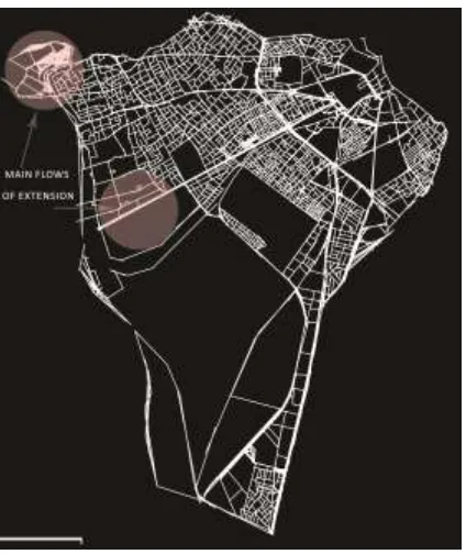
Space syntax investigates transportation system and traffic flow. The traditional ways to represent the urban network have some inefficiencies in making depictions about vehicular movement. Therefore, in order to represent the urban grid with priority given to the vehicular movement. In addition to pedestrian and vehicle movements, two different axial maps were used in order to evaluate these different types of movements. This could be seen as a reinterpretation of spatial configuration (Dalton, 2001). Both the syntactic analyses and the analyses of deformed landscapes show the dominant character of highways and their effects on land use, and thus the possible direction of urban sprawl in Monastir. The study identified the built-forms of four main category; the process of peripheral urban sprawl was marked by the share of the actors of the civil society, which benefited from the living environment of the city. By these actions, the social players who seemed guided by the urban politics at the beginning of the promotion of the city of Monastir, managed today to produce a spatial model determining a determined social segregation.
Results And Discussion
The metamorphosis of the city of Monastir:
After the Independence and under the government of Bourguiba, the development of the tourist, industrial and administrative activities favored the extension of the city along the roads, which connect it with Sousse, Kairouan and Mahdia. The city knew a major growth after the independence, spreading out beyond ramparts. This processing was impulsed by the former president of the Republic, Habib Bourguiba (1956-1987), native of the city and inspirator of an action of urban modernization. The city of Monastir knew a metamorphosis under the effect of the President. In fact, there was an important demolition of the part Est. of the Medina of Monastir. A view released on the mausoleum of Bourguiba, which was realized at the expense of a part of the cemetery. It found however its city vocation of the knowledge as hospitalo-university pole because of the creation of the Faculties of Medicine, dental Medicine and Pharmacy and a college of the sciences and techniques of the health. The city also became a scientific and technological pole making of Monastir a student city.
The new city of Monastir welcomes sports, school, university and hospitable equipments, which train a very consumer belt of spaces around the old center. These realizations take place with the blessing of the inhabitants of Monastir who accept the expropriation of their grounds to build these public equipments. Fitted out to the detriment of the agricultural space, equipments were endowed with vast gardens to confer on the city certain landscaped aspect. During this period, the architect Cacoub designed places in front of both seats of the municipality and the governorate to establish a new urban centrality. Moreover, he was himself the architect of the majority of the new equipments and the most symbolic building of Monastir.
The urban dynamics comes along with an evolution of economic activities in the field of the departments of the industry and of the tourism. Industrial units are realized in the South, whereas the tourist spaces extend in the North, along the coast. Since the 1970s, a tourist zone was born to Monastir. In 1985, the realization of the project of the marina confirms the birth of a tourist pole to Monastir. Around these tourist projects situated in the North of the city, extend residential zones reserved for an upper middle class.
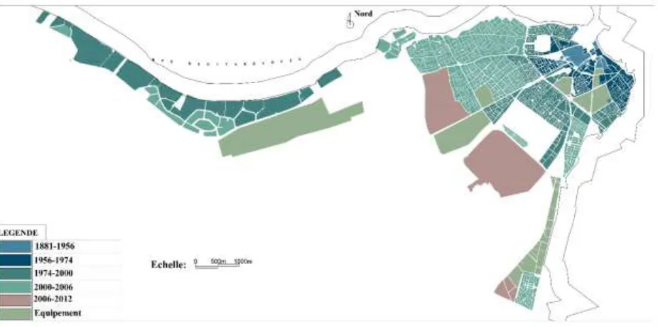
Figure 2. Land-use Map with urban sprawl phases
The first crown presents the zone the closest to the sea and containing the Medina, the cemetery, the Ribat and the marina. It is the core of the social, tourist and administrative and cultural activities. The modernization of the city crossed by the realization of numerous equipments and infrastructures, in particular wide avenues and living districts or we can recognize tracks of the modern current in architecture. Afterward, the effects of the combined development of the tourism and the industry aroused an urban expansion. In 1974, the city of Monastir reached to the rank of administrative center of Governorate. In the same period, the first railroad station was going to allow a new way of moving in the region. From the point of view its social composition, this part shelters at present almost exclusively a compound population at present of rehoused. These result from districts of housing environment of a lower middle class. Since its destruction further to the decision of the Ex-president Bourguiba, the medina underwent deep transformations of its structure and its social composition by the simultaneous departure of elites and the arrival of an important population stemming from the drift from the land. The former tight fabrics and low surfaces densified in a disturbing way, weakening consequently the built and striking a blow at the architectural heritage of this city. Symmetrically, this urban population density, led to the estrangement of the average and upper middle categories which find themselves massively in the suburb and died urban, that is in the least accessible municipalities.
Figure 3. The second crown of urban fabric of Monastir
The third crown is a mainly residential zone containing new living districts, big dense popular zones where the urban problems are important. These districts were not conceived to evolve according to the needs for the citizens. The urban evolution was partially spontaneously made, without planning of sufficient equipments. It results from it an enormous problem of traffic. These places of the former summery residences, the plum tomatoes and the naked grounds of Skanes Essouani did not escape the efforts of urban planning. The closeness of the sea explains its reservation to the housing environment of the upper middle families.
An external outlying suburbs developed by the average categories to superiors. The new outer-urban space appears as a space laboratory. The outer-urban crown of Monastir receives territories and landscapes of a diversity and a complexity for which it is necessary to try to understand and to characterize. In this southwest zone, exist the only green zone affected by PAU of 1991, called Bou Rachah, as well as residual fields of olive tree. Close relations of Ben Ali had the privilege to build a lot, exactly in the margins of the golf course of Monastir there, taking advantage of its affectation in «equipped green Zone ". (Hellal 2013)
The policy of development in front of the urban sprawl:
We observe in the document below realized by the overlapping of the air maps the scale of the urban extension which knew the city of Monastir of a compact shape in a form pressed down or the peripheral housing environment became a landscape of the hinterland.
Since 1990, the local administration of Monastir privileges to the close relations of Ben Ali, especially to those who live in town: authorization to build buildings without respect for the urban regulations, the realization of the urban projects and the services except the urban perimeter (Hellal on 2013).
On the other hand, this spatial injustice is rather "visible" in the city to influence its functioning. The city center suffers from traffic jams because of the dispensations granted to certain people to realize buildings along the surrounding wall of the medina; the city did not know improvement of the road network and lack of parking lots. In this context, the outer-urban space appears as an adequate solution for a certain social category to avoid the problems bound to the city center. (Hellal 2013).
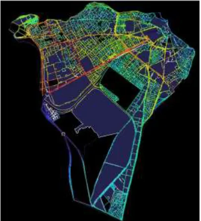
Morphological Transformations and urban sprawl Analysis: Space Syntax: a Theory and Method for house form analysis
The Space Syntax theory, developed by Hillier and Hanson, helps to bridge the gap between the spatial analysis and the social interpretation. The morphological characteristics of a plan layout are analyzed with the help of graphs called “justified access graphs” [Hillier and Hanson, 1988]. In space syntax, to measure and evaluate configuration, first, the justified format of the access graph is drawn. In these graphs, all spaces of the house are appointed depth values according to a chosen space called “the carrier.” After the graphs are formed the analysis shows that some numeric measurements related to the properties of spatial configuration can be made. Visibility refers to Visual information provided to the observers at any given location. Visibility graph analyzes [VGA] the extent to which any point in a spatial system is visible from any other. Through this visibility graph analysis we can obtain numerous measures of both local and global spatial properties that seem likely to relate to our perception of the built environment [Turner, et. al., 2001]. The local measure visual control gives us locations that have the maximum visual control, i.e. spaces that might be called controlling. This picks out visually controlling spaces that can see more [Turner, 2003]. Along with visual control of space VGA provides the visually most integrated space in a domestic organisation that relates privacy of the female members in a domestic environment with its visibility aspect.
The above analysis confirms the importance of the social as an important parameter in the creation of space: Apart from political, economic and of course spatial, space needs to also be treated as social. Social agency as well as political intentions need to be considered as part of the fundamental constitution of space. Furthermore, the social, as well as the economic and political are configurational not only in space but also in time. A general remark of research findings this far could then be that, irrespective of identity, the powerful, whether politically or economically, tend to be found in more globally integrated areas than the remaining weaker groups that make up the specific urban entity.
Figure 5 : Monastir axis Integration values (R-n)
Conclusion
The aim of the present paper was to identify the various metamorphoses on the monasterien cordon. A new landscape is born during the last decades. The analysis of the zone of study allowed us to emphasize the importance of the social players in the way of guiding the urban sprawl. The process of urban sprawl generates a dilution of the social fabric of the city and a bigger landscaped differentiation between urbanized zones, what intensifies the disparities and the trends of a socio-spatial selectivity.
The house, considered as socio-spatial basic unit is the laboratory of the urban landscape. The changes in the social orders and in the lifestyles dictate the transformations in the urban territories. The medina, being a former politeness, restructures by restoration and renovation and appears as an abandoned space today, even incapable to meet the needs of the modern society. In the new central and peripheral spaces under construction, the tertiary establishments, as well as the hotels and the administrative establishments played an important role in the emergence of a differential housing environment. The public actors were the initiators of this emergence. On the other hand, the upper middle population participates in it by the reappropriation of new spaces dedicated previously to the tourism in the logic of to look ' of the green ' outside the center, the possibilities of more spacious housing, outside the perimeter of environmental urban degradation. These residential completely high statuses are encircled by walls, kept, with adequate infrastructures, and located on important main highways. All the social and spatial processes in functioning in the urban spaces is comparable to the processes of the urban sprawl.
References
1. J. Hanson, “Order and structure in urban space: a morphological history of the city of London”, Unpublished PhD. thesis, University of London, 1989.
2. Hanson J., Hillier B., The architecture of community: some new proposals on the social consequences of architectural and planning decisions, Architecture and Behaviour 3 (3): 251-273, 1987
5. Dalton, N., 2001, “Fractional Configuration Analysis and a Solution to the Manhattan Problem”, J., Wineman, J., Bafna, S. (Eds.), Proceedings, 3rd International Space Syntax Symposium, Georgia Institute of
Technology, p.26.01-26.13., Atlanta, USA.
6. R. Lamine, ‘Ville et citadins du Sahel central”, Collection the Gold of time. University of the Center, Faculty of arts and Human sciences of Sousse.