© 2017 IJSRSET | Volume 3 | Issue 6 | Print ISSN: 2395-1990 | Online ISSN : 2394-4099 Themed Section: Engineering and Technology
Fit for Purpose Cadastral Information System for Sustainable
Development in Fadaman - MADA, Bauchi
BABALOLA Sunday Oyetayo*1 ABIDOYE A. I.2 , OGUNLADE S. O.1 & KARDAM M. S.3
1
Department of Surveying & Geoinformatics, Federal University of technology Akure Nigeria
2
Faculty of Environmental Design and Management, Obafemi Awolowo University, Ile-Ife, Nigeria.
3
Department of Surveying and Geoinformatics, Federal Polytechnics Bauchi. Bauchi
ABSTRACT
The FFP way to deal with land administration system has risen as a distinct advantage for creating nations and offers a suitable, down to earth answer for rapidly and affordably give security of tenure to all and to empower control the utilization of all land. The Fit-for-Purpose arrangements give chances to land administration system to convey benefits, including secure tenure rights, to an extensive variety of partner inside a generally brief time and for a moderately affordable expenses in an adaptable way. This study composed and update the entire Fadama-mada area with a sweeping computerized delineate cadastral information in order to fulfill budgetary and supportable improvement in accordance with fit for purpose land administration framework.The raster image from the simple maps was additionally completely used. Scanned image was sent to Auto CAD environment for appropriate geo-referencing. Places of refreshed highlights were included utilizing coordinate geometry (COGO). Illustrations were legitimately altered utilizing Arc view3.2a delicate product condition. Designs were connected with non-spatial attributes data base. The result of this activity was checked by a few GIS operation and examination, and digital map of Fadama-mada was produced. Results were appeared in illustrations and tables. Having finished this study, cadastral information system (CIS) has ended up being a dependable productive apparatus that can be utilized as a part of the checking, assessing and management of cadastral records in our services and nearby government workplaces and other related organizations and government foundation for reasonable development.
Keywords: CAD, OGO, LINZ, GIS, CIS, VMDS
I.
INTRODUCTION
The fuel driving the motor of development and feasible development of any country is the country's entrance to dependable and adequate geo-information. In most developed nations, more than 80% of sane and planned allotment and natural management choice depends on quality and exact information. Then again, the underlying foundations of a work in progress of developing nations, for example, Nigeria radiated from various components which incorporate low quality data accumulation, organization, and management practices and absence of satisfactory learning to build up the range and deal with the earth in an economical way (Babalola et al., 2016). The results of all these are evident from air and water contamination, natural corruption, maladies and passing. The Fit-for-Purpose
In view of the endorsed outline, the fadaman-mada design was appropriately executed, however today issues have truly influenced the region which are firmly related with issues of simple maps planning of putting away controlling, surveying, and recovery of cadastral information.
Since simple cadastral maps are as yet being utilized for development, organising and even acknowledged as legitimate archive in settling land question in our courts, issues, for example, recovery of cadastral information, controlling and evaluating expansive volume of information still remain a noteworthy issue. The instance of Fadama-mada territory is not unique in relation to the general standard. Today the development design has been truly influenced. For example, Muslim burial ground yard has been authoritatively extended by the government there by taking a significant number of private plots that fall inside the extended territory.
Plot for Nigeria Television Authority Transmitting Station (NTA) has been extraordinarily limited significantly. The activity of specialist in correcting the prior outlined plots has made an empowering situation for forthcoming engineers, land surveyors and even some government authority to take part in some unlawful exercises. Since information of the territory has been misshaped, missed, or even crushed totally which is extremely basic with simple maps. This deplorable occurrence has made a major issue the government in controlling and managing the great arranging nature and development of the range. Considering the issue specified above, if a far reaching spatial data of the present zone is completely created, it will check, stop and even uncover the illicit dealings occurring in the range, and it will additionally be utilized as an apparatus for building up the territory and even fill in as a model for controlling future developmental plans for the state and the country at large.
One of the essential parts of any cadastral framework is the cadastral maps. Be that as it may, the current system in the study area comprising of paper maps and customary land registers are getting to be plainly wasteful, thus a cadastral information system (CIS) in view of digital cadastral map in which attributes and map data on cadastral unit put away in similar data base can't be overlooked. The part of this cadastral
information framework is to upgrade the overseeing and controlling the land assets, with an attention on manageable development. The coming of computer innovation is the essential device that modernized the current cadastral framework. Some government are compelled to enhance the current framework because of the way that the old framework is getting to be noticeably wasteful in zones, for example,
i. Low exactness of geometric data
ii. The trouble of the simple type of cadastral looking over map with paper.
iii. Slowness of refreshing, recovery and capacity process in the ordinary framework.
iv. The incapacity for performing examination and report in a simple way.
All these are a portion of the reasons that spurred this study.
This study is gone for building up a cadastral information system (CIS) of fadaman mada area of Bauchi metropolis for reasonable development with the accompanying destinations.
Study Area
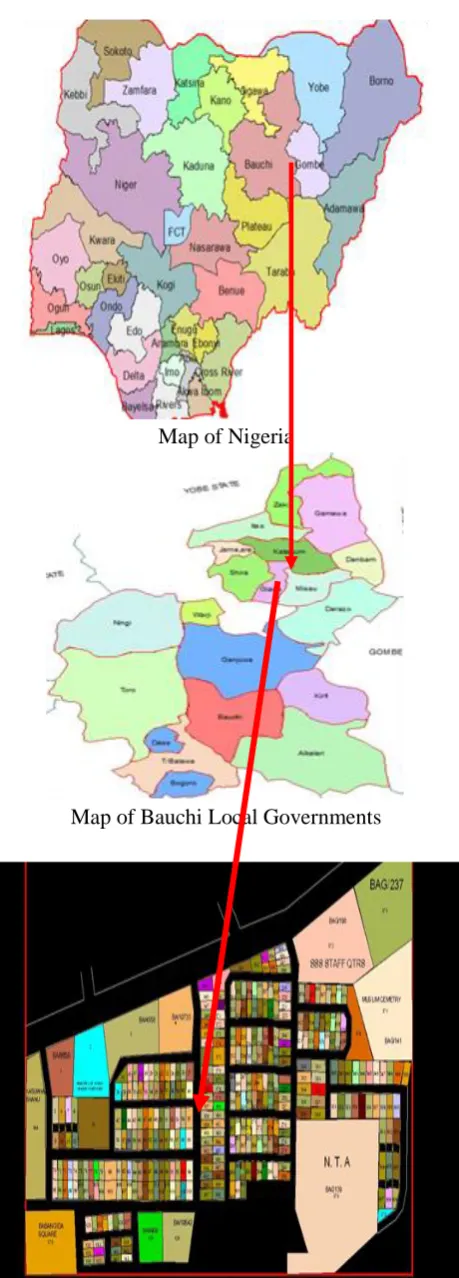
The study area of this undertaking is Fadaman Mada format design DP/8A in Bauchi Local Government of Bauchi State and is along Bauchi – Maiduguri street. The zone is limited by Babangida Square on the west and Sultan Abubakar Road on the North and limited by the accompanying UTM coordinates.
(593302.542E, 1143077.321N)
(594402.711E, 1143077.321N)
Map of Nigeria
Map of Bauchi Local Governments
Figure 1: Maps showing the Location of the study area. (Ministry of lands and Survey Bauchi)
Assessments of some past works around there have demonstrated some change on the investigation of cadastral information system. In a few nations some
reasonable tasks were directed to stretch out the regular framework to cover new issues, for example,
Automation of administrative errands.
Development of utilizations for dealing with the cadastral registers.
Development of logical instruments for setting up digital cadastral maps and plans.
Automation of land management for solidification issues.
Usage of land information framework. Fit for purpose land administration system.
As indicated by Elayachin and El-hassane (2001) and (Babalola et al., 2017) the outline and execution of a digital cadastral framework which require an approach that empowers the incorporation of cadastral operations with GIS packages and a device that ought to be useful in a multipurpose framework can be accomplished through three levels.
a. In the primary level, the current cadastral applications must be comprehended and all venture led for modernizing cadastral system ought to be examined.
b. In the second level, it is important to diagram diverse strategies for connecting cadastral data models to GIS programming, where the current techniques, their qualities and shortcomings are talked about.
c. The third level is worried about the way to execute the imagined framework.
Buragohain. etal (2002) Akingbade (2005.) developed a land information framework utilizing coordinated remote detecting and GIS Technology for Guwahati city India and Nigeria respectively, keeping in mind the end goal to concoct a propelled database management framework (DBMS) for the city. The system embraced in the investigation was the map of Guwahati city and its encompassing territories were digitized. The mechanical data contains the qualities of the depleting system, street and railroad organize and additionally foundation offices in the city.
digital data. Toward the end plot insightful urban land utilize map was arranged and attributes were allocated for each plot with full proprietorship and develop information. The aftereffect of the exploration was finished by building up a choice emotionally supportive network made to supply information in regards to each plot with its all attributes. What's more, a database was changed over into a web upheld design and is modified to give question offices to quick and prepared extraction of information through web.
In 1925 Turkey's cadastral framework has been shaped by the state with a few lawful and organizational alterations. These changes have brought about an absence of standardization and irregularity in the geometric part of the cadastral data, for example, the cadastral maps without a co-ordinate framework or in various coordinate framework.
The issue with respect to data standardization, data quality, data irregularity, digital filing and the gradualness in cadastral
Administrations compelled to make a change in Turkey's cadastral framework tending towards a PC – based cadastral information framework (CIS). In the investigation, the necessities of a cadastral database were broke down and a spatiotemporal database was planned and created to satisfy the prerequisite for spatial, transient database and spatiotemporal questions for cadastral data. The Spatiotemporal uses Entity-Relationship (STEP) show in blend with the Enhanced Entity Relationship (EER) demonstrate. Prophet 8i spatial was picking as (DBMS) since it gives spatial data taking care of ability.
The consequence of the examination was a making of database tables characterized in consistent pattern utilizing Oracle 8i spatial, where the cadastral and land registry data of the investigation territory were stacked into the database tables made. Prophet 8i does not give realistic alter and show work for spatial data, map information 6.0 GIS programming was utilized to recover, show, control and break down the cadastral data.
Tella Fralk and Rably P. (2002) is an examination to blend the old cadastral records with the new cadastral records, making a strong cadastral database named VMDS. The VMDS contained both the georeferenced
unique data and the attribute data. He accomplished this by essentially entering in the information in the old cadastral data likewise, the issue expected on the first disarray between the old and the new data. The new CIS data now has expelled the perplexity.
In an examination titled cadastral mapping and land information framework, Reghavendran (2002) depict how a computerized cadastral mapping and land information framework will be made. He traces two fundamental issues of worry for setting up a cadastral information framework.
Spatial segment/overview data depicting the spatial demeanor of the bundles in this present reality cadastral maps and
Non spatial segment portraying subtle elements, for example, possession points of interest, charge esteem e.tc.
He utilizes spatial database (SDE) for the spatial segments and small scale station geographic for the non spatial data. For redid question and report era, the database was placed in Oracle organize. Toward the end, investigation with the new (CIS) were boundless however, its relies upon the data that has been put and also the client prerequisite.
Shuaibu (2008) in his M.tech work, cadastral land information framework for supportable land transport in Bauchi state, he utilized the current simple map of the investigation zone old Government held Area Bauchi (GRA) which he changed over to digital organization utilizing a digitizing tablet in ILWIS condition. A computerized attribute database for the spatial database was made in an Arcview situation which was subjected to question and examination. He could demonstrate land secured by testament of inhabitance, number of plots for private, amusement and business in the digital map he created.
take care of the developing group demand for enhanced nature of cadastral works (Bevin1999)
The foundation of Abuja Geographic information framework (AGIS) in Nigeria Capital city has changed the general way to deal with land organization in the city. The simple cadastre was changed over to digital organization and new testament of inhabitance issued out to previous holders of titles inside the capital domain. Before the making of AGIS land exchanges in the city was described by duplication of titles, delay in inquiries and land movement not legitimately registered.(www.abujagis.com).
Considering the different investigations featured in this survey particularly, the issues that required the different undertakings, the kind of data utilized, the procedure received, the hardware and instruments utilized and additionally the advantage determined toward the finish of every examination, there is a change in the investigation of CIS however no work has been done in the study area.
II.
METHODS AND MATERIAL
The essential data source is the field study, which included field refreshing utilizing electronic aggregate station (sokia set 600) and hand held GPS to acquire the field co-ordinates. While the optional data comprise of the accompanying:-
The cadastral format square review design of fadaman-mada from Ministry of land bauchi state.
The road map of Bauchi town and other auxiliary data utilized incorporate course books, diaries, meeting papers and class procedures. The attribute data (Non spatial data) were acquired from the Bauchi state Ministry of Land and Survey, which incorporate the accompanying: Parcel information, Ownership, Registration of titles, Deeds, Division, Location and other attribute information were acquired by physical examination. A current plan overview of Fadaman-Mada was digitized utilizing on screen. The coordinate of the considerable number of changes made on the first cadastral format which was acquired through field study utilizing all out station and the attribute information of individual parcel were gotten through Ministry of lands. The current cadastral map was changed over into delicate duplicate utilizing an AutoCAD domain: the
refreshing of the digitized map was accomplished by utilizing (COGO) in the same AutoCAD condition while table made, inquiries and examinations were done in a bend see condition.
Data Processing
Four referenced co-ordinate concentrates that by and large appeared on the four corners of the separated Fadaman - mada configuration were plotted in the AutoCAD environment. The plan was checked using scanner, which was later exchanged into an Auto CAD environment. By then through the "insert'" menu, raster image was clicked to get the inspected Fadaman - mada image into a comparative circumstance of the plotted four co-ordinates using R14 overlay.
From the image menu, through the associates sub menu, versatile sheet was clicked to start the geo-referencing. Along these lines, the source concentrates on the analyzed image were clicked trailed by clicking their individual objective concentrates on the plotted four co-ordinates.
In the wake of tapping the last concentrations "enter" arrange was clicked which immediately versatile sheet (Geo-referenced) the checked Fadaman-mada image to the georeferenced centers was expert. Digitizing was in like manner done by "freehand" using the on-screen digitizing capacities of AutoCAD 200i
The table for the parcel was therefore package for the document outside into the Arcview environment. Along these lines table creation here included changing the table for the package so made. Modifying, including deleting undesirable areas normally made by the Arcview and influencing sections of interest. The fragment of interest are those properties information that were procured through physical audit and from the Ministry of Land and Survey, for instance, ownership address, ownership name, occupation, change of ownership, change of purposed, plot number, circulate, record number, date of C of O, and so on. It should be seen that while influencing new to fragment, the portion space close to nothing or broad, the character of information, numbers, string or date was totally considered.
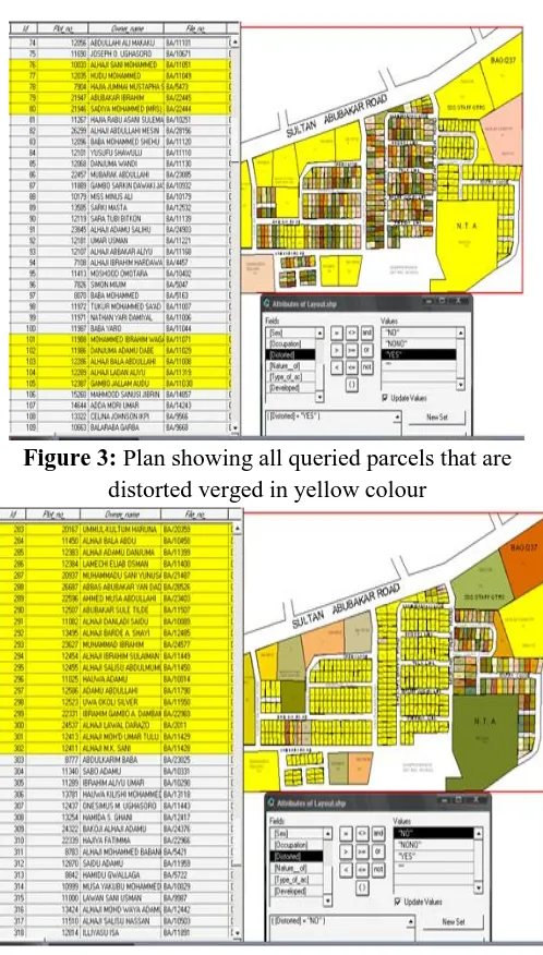
Generating the Queries
These query showed the legitimacy of the database both spatially and non-spatially.Arcview 3.2a was used as a piece of delivering queries by trait and moreover by area from the database table with the used of query maker image. These were proficient as taken after: Every contorted plot on the map and the records containing attributes of the plots were naturally shown. This study has a total of 16 fields and 376 records. The fields includes:-
- The identification number of the respective parcels.
- Parcels ownership address. - Ownership occupation. - Division of parcels. - Parcels date of certificate. - Parcels location.
- Parcels distorted. - Parcels file number. - Present parcel owner. - Parcels land use.
- Nature of distortion among others.
Figure 3: Plan showing all queried parcels that are distorted verged in yellow colour
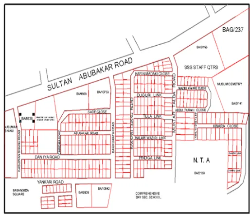
Figure 4: Plan showing all queried parcels that are not distorted verged in yellow colour
Figure 6: Plan showing changes made on the original plan in blue.
Figure: 7 Plan showing both the spatial and attributes database
III.
RESULTS AND DISCUSSION
Speedy and precise choice going up against land matters which are one of the imperative fixings fundamental for any monetary development of any association was completely upgraded. The study has shown that cadastral information system (CIS) is fit for creating a precise computer aided cadastral map. It has likewise shown that (CIS) can adapt to substantial volume of spatial and non-spatial information in fit for purpose land administration system. Usage of a robotized cadastral information system will go far in helping the significant specialists accuse of the obligation of dealing with land records all the more proficiently. Thus (CIS) has additionally given the expert a chance to make some run of the mill studies.
In the appraisal of land utilize changes and their causes.
- In the evaluation of land utilize infringement and construction standard infringement.
- In the deal exchange of a specific parcel or for the entire piece.
- In the appraisal of property for issues of planning authorization.
At last it can likewise fill in as an intuitive methods for land information for prompt and prepared extraction of plot shrewd points of interest through the multi question office that was given in the database which enable any individual client to accumulate information with respect to land holding.
The main target of this study is to digitize the current Layout of the study area so as to change over it to delicate duplicate for encourage the analysis.
Figure 8: Plan showing the digitised details of the study area.
Therefore, the advantages of this digitized map is that:-
i. It can be readily edited at any time.
ii. Each include in the digitized plan can be spared in an individual layer for a particular client require. iii. Each specific component in the digitize plan can be
questioned for a particular investigation.
iv. Better and new images of highlights can be increased the value of the plan as far as beautification of the plan.
disavowal of some private plots. Nonetheless, the extension has offered path to the mutilation of some forgotten private plots and even some administration plots for example, NTA Transmission Station via land examiners, land surveyors and additionally some administration authorities because of the simple idea of the format plan. Some private plots have been changed over to different uses, for example, ads and religious exercises. Roads at first intended for double carriage were presently decreased to one path; others that are at first shut are currently reached out to meet the significant ones.Besides, plots were additionally subdivided into littler or greater sizes than prior outlined. The significant changes can be found in figure 6, skirted in blue colour.
The aggregate storage room boundary of this investigation is 9.48MB around 10MB. This infers the whole database can be put away in a solitary CD or glimmer drive. Considering the capacity limit of a solitary CD which is around 700MB showing that such stockpiling gadget can contain 70 sorts of this database, talk less of contrasting it and blaze drive of 2G. Subsequently one can infer that there is high level of transportability, since 100 of CD's can be conveyed along anyplace whenever. Thus the amount of information that can be put away in a solitary CD if changed over to the simple identical would have been enormous voluminous information that can't be effortlessly conveyed anyplace whenever.
So also another extraordinary preferred standpoint of this study is the adaptability of the database where the two designs and property information can be effectively altered, not at all like in the simple strategy where such adaptability is exceptionally troublesome. Likewise the speed at which information are recover in under a moment can't be contrasted and the conventional strategy where it takes days before information are gotten. At long last there is likewise provision for entomb availability among the workplaces of the high positioning officer's accuse of the duty of land related issues inside a ministry and also different offices that straightforwardly manages land records. It can likewise be in a site based which makes it effectively open and hearty. Henceforth it can't be effectively annihilated. This has given the database a decent security over being lost.
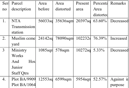
Table 1. Table of distortions
From the table above, it has been shown that about 63.60% of the total area design to be premises of the NTA (Nigerian Television Authority) Transmission Station has been distorted due to the analogue way of the initial design of the area. Also about 76.39% increase of the cemetery yard was discovered due to the official expansions of the cemetery yard by the Government thereby converting some parcel to accommodate the desired total area needed as against the initial proposal. The table gives final analysis of some plots within the area that were either distorted legally or illegally.
IV.
CONCLUSION
This study on fit for purpose cadastral information system for sustainable development in fadaman –mada, bauchi. Developing was gone for infusing the digital innovation framework into cadastral procedure of land administration in Bauchi, in this manner changing from simple arrangement of putting away, evaluating and recovering cadastral data. The systems and general methodology for digital cadastral map have been completely portrayed in the study. The examination additionally indicated how computer innovation has come to assume an indispensable part in keeping cadastral record by making it workable for information to be kept in various configuration, enabling them to be gathered in any coveted way by people, ministries or parastatals that are specifically required with land related issues in fulfilling their required needs.
This study is just a single out of the various developmental format designs that secured the state Serial no Parcel description Area before Area distorted Present area Percentage Area distorted Remarks
1. NTA Transmission station
56033sqm 35636sqm 20397sqm 63.60% Decreased
2. Muslim cemetery yard
24142sqm 78090sqm 102232sqm 76.39% Increased
3 Ministry of Works
And Housing Junior
Staff Qtrs
1085sqm 578sqm 10272sqm 5.33% Decreased
4. Plot BA/9909 & Plot BA/10642
capital and the metropolis specifically that are yet to get the new innovation. The scientist accordingly, prescribe significant services, offices, different specialists in the state to proceed from where this exploration venture ceased if the state must achieved an economic development. This essayist ache for the political readiness of people with great influence to support the State Ministry of Land and Survey so the most recent satellites imageries of the state capital can be effortlessly gained for appropriate checking and discovery of land utilize infringement and changes inside the metropolis so as to think of an up and coming (CIS) for feasible development. The utilization of GIS ought to in this manner, be grasp in creating digital cadastral maps. The requirement for classes, workshops, preparing and re-preparing of faculty in the field of geo informatics ought to be exceptionally encourage. The state will infer a considerable measure of social and financial advantages from an effective geospatial data foundation and cadastral database for productive and appropriate co-appointment of geospatial information in the state.
In this way, snappy change from simple cadastral framework to digital framework is unequivocally prescribed to all offices, Ministries and parastatals identified with land matters. Likewise a free mapping organization be set up in all situations of the league for legitimate land use keeping in mind the end goal to keep up manageable and defensive condition.
V.
REFERENCES
[1]. Akingbade, A.O. (2005.). Improvement of Availability of Land Registration and Cadastral Information in Ondo State, Nigeria. Enschede, the Netherlands: International institute for geo-information science and earth observation.
[2]. Babalola, S.O., Abdulrahman, A., Choon, T.L. and Isong, M. (2016). Network Processes and Web Design for Land Registration in Land Administration System of Nigeria. 2nd International Conference on Science, Technology and Social Sciences 2016 UTM Johor Bahru Malaysia.
[3]. Babalola, S.O., Alias, A.R., Tan, C.L., Iyanu, A.A. and Olatunbosun, A.A. (2017). Internet application for online cadastral services : A case study in Nigeria. Journal of Advanced Research Design,. 36(1 (2017) 1-12), 1-12.
[4]. Buragohain D R.(2002) Development of a web based land information system.LIS Using integrated Remote sensing and GIS Technology for Guwahati city India. Abhinava ,PVT Ltd Guwahati Assam India.
[5]. Bevin A.J (1999) Cadastre 2014.Reforms in New Zealand.Proceeding of FIG commission VII AGM, Waitingi pp99
[6]. Enemark, S., Mclaren, R. and Lemmen, C. 2015. Fit-For-Purpose Land Administration Guiding Principles Online]. www.flossola.org, www.gltn.net. . Accessed 17/4/2015].
[7]. Elayachin and El-hassane S.(2001). Digital Cadastral map: multipurpose tool for sustainable developments. International Conference on Spatial Information for sustainable development. Narobi, Kenya.
[8]. Dale, P. and Mclaughlin JD. (1999) Land Administration system, Oxford University Press London.
[9]. Fabiyi Y.L. (1984) Land administration in Nigeria: Case studies of the implementation of the Land Use Decree (Act) in Ogun, Ondo and Oyo state of Nigeria.
[10]. Raghavendran S.(2002) Cadastral Mapping and Land Information System.GIS,Pixel infortek Pvt.ltd.www.GIS development.net.com
[11]. Shuiabu (2008) Cadastral land information system for sustainable land conveyance in Bauchi State. M.tech Project Department of Surveying and Geoinformatics. Federal University of Technology Yola.