www.solid-earth.net/5/227/2014/ doi:10.5194/se-5-227-2014
© Author(s) 2014. CC Attribution 3.0 License.
Solid Earth
The Cretaceous and Cenozoic tectonic evolution of Southeast Asia
S. Zahirovic, M. Seton, and R. D. Müller
EarthByte Group, School of Geosciences, The University of Sydney, Sydney, NSW 2006, Australia
Correspondence to: S. Zahirovic ([email protected])
Received: 2 August 2013 – Published in Solid Earth Discuss.: 21 August 2013 Revised: 14 January 2014 – Accepted: 14 March 2014 – Published: 29 April 2014
Abstract. Tectonic reconstructions of Southeast Asia have
given rise to numerous controversies that include the accre-tionary history of Sundaland and the enigmatic tectonic ori-gin of the proto-South China Sea. We assimilate a diversity of geological and geophysical observations into a new re-gional plate model, coupled to a global model, to address these debates. Our approach takes into account terrane sutur-ing and accretion histories, the location of subducted slabs imaged in mantle tomography in order to constrain the evo-lution of regional subduction zones, as well as plausible absolute and relative plate velocities and tectonic driving mechanisms. We propose a scenario of rifting from northern Gondwana in the latest Jurassic, driven by northward slab pull from north-dipping subduction of Tethyan crust beneath Eurasia, to detach East Java, Mangkalihat, southeast Borneo and West Sulawesi blocks that collided with a Tethyan intra-oceanic subduction zone in the mid-Cretaceous and subse-quently accreted to the Sunda margin (i.e., southwest Borneo core) in the Late Cretaceous. In accounting for the evolu-tion of plate boundaries, we propose that the Philippine Sea plate originated on the periphery of Tethyan crust forming this northward conveyor. We implement a revised model for the Tethyan intra-oceanic subduction zones to reconcile con-vergence rates, changes in volcanism and the obduction of ophiolites. In our model the northward margin of Greater In-dia collides with the Kohistan–Ladakh intra-oceanic arc at ∼53 Ma, followed by continent–continent collision closing the Shyok and Indus–Tsangpo suture zones between ∼42 and 34 Ma.
We also account for the back-arc opening of the proto-South China Sea from ∼65 Ma, consistent with extension along east Asia and the formation of supra-subduction zone ophiolites presently found on the island of Mindoro. The re-lated rifting likely detached the Semitau continental frag-ment from South China, which accreted to northern
Bor-neo in the mid-Eocene, to account for the Sarawak Orogeny. Rifting then re-initiated along southeast China by 37 Ma to open the South China Sea, resulting in the complete con-sumption of proto-South China Sea by ∼17 Ma when the collision of the Dangerous Grounds and northern Palawan blocks with northern Borneo choked the subduction zone to result in the Sabah Orogeny and the obduction of ophi-olites in Palawan and Mindoro. We conclude that the coun-terclockwise rotation of Borneo was accommodated by oro-clinal bending consistent with paleomagnetic constraints, the curved lithospheric lineaments observed in gravity anomalies of the Java Sea and the curvature of the Cretaceous Natuna paleo-subduction zone. We complete our model by construct-ing a time-dependent network of topological plate bound-aries and gridded paleo-ages of oceanic basins, allowing us to compare our plate model evolution to seismic tomogra-phy. In particular, slabs observed at depths shallower than ∼1000 km beneath northern Borneo and the South China Sea are likely to be remnants of the proto-South China Sea basin.
1 Introduction
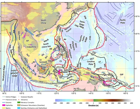
Fig. 1a. Regional tectonic setting with plate boundaries (MORs/transforms = black, subduction zones = teethed red) from Bird (2003) and
ophiolite belts representing sutures modified from Hutchison (1975) and Baldwin et al. (2012). West Sulawesi basalts are from Polvé et al. (1997), fracture zones are from Matthews et al. (2011) and basin outlines are from Hearn et al. (2003). ANI – Andaman and Nicobar Islands, BD – Billiton Depression, Ba – Bangka Island, BI – Belitung (Billiton) Island, BiS – Bismarck Sea, BP – Benham Plateau, CaR – Caroline Ridge, CS – Celebes Sea, DG – Dangerous Grounds, EauR – Eauripik Ridge, FIN – Finisterre Terrane, GoT – Gulf of Thailand, GR – Gagua Ridge, HAL – Halmahera, HBa – Huatung Basin, KB – Ketungau Basin, KP – Khorat Platform, KT – Kiilsgaard Trough, LS – Luconia Shoals, MacB – Macclesfield Bank, ManTr – Manus Trench, MaTr – Mariana Trench, MB – Melawi Basin, MDB – Minami Daito Basin, MG – Mangkalihat, MIN – Mindoro, MN – Mawgyi Nappe, MoS – Molucca Sea, MS – Makassar Straits, MTr – Mussau Trench, NGTr – New Guinea Trench, NI – Natuna Islands, ODR – Oki Daito Ridge, OJP – Ontong Java Plateau, OSF – Owen Stanley Fault, PAL – Palawan, PhF – Philippine Fault, PT – Paternoster Platform, PTr – Palau Trench, PVB – Parece Vela Basin, RB – Reed Bank, RMF – Ramu-Markham Fault, RRF – Red River fault, SEM – Semitau, ShB – Shikoku Basin, Sol. Sea – Solomon Sea, SPK – Sepik, SPT – Sabah–Palawan Trough, STr – Sorol Trough, Sul – Sulawesi, SuS – Sulu Sea, TPAA – Torricelli–Prince Alexander Arc, WB – West Burma, WCT – W Caroline Trough, YTr – Yap Trough.
1991; Acharyya, 1998; Golonka, 2004; Hall, 2002; Stampfli and Borel, 2002; Metcalfe, 2006). The northern Gondwana margin, as the origin for many of the Asian continental frag-ments, was a passive boundary for much of the Mesozoic, with periodic rifting events that carried continental slivers on the Tethyan oceanic plates that acted as conveyors trans-ferring terranes onto the southern Eurasian margin (Audley-Charles, 1988; Veevers et al., 1991; Seton et al., 2012).
The Sundaland core, forming much of the Sunda shelf and continental promontory in Southeast Asia (Fig. 2), is largely composed of the Cimmerian terranes that rifted from
Fig. 1b. Regional tectonic setting of the Philippine Sea plate, Papua New Guinea and the Caroline Plate, following symbology of Fig. 1. The
crystallization ages of ophiolites were used to infer oceanic crust age, while the metamorphic age was used to infer collision and obduction. A – Lagonoy Ophiolite, B – Calaguas Ophiolite, C – Dibut Bay Ophiolite, D – Casiguran Ophiolite, E – Montalban Ophiolite, F – Zambales– Angat Ophiolite, G – Itogon Ophiolite, H – Marinduque Basin/Sibuyan Ophiolite, I – Mindoro/Amnay ophiolites, J – Palawan Ophiolite, K – Pujada Ophiolite, PUB – Papuan Ultramafic Belt, COPB – central ophiolite belt.
of these blocks on the northern Gondwana margin is con-troversial, in particular whether they all originated from the Argo Abyssal Plain, hence the “Argoland” name applied to blocks from this segment of the northwest Australian shelf, or whether some of these blocks originated from the New Guinea or even Greater Indian passive margin. In addition, the nature of the microcontinents on Sumatra has been
dis-puted, and recent studies have argued that these are more likely to be accreted intra-oceanic island arcs with no conti-nental basement (Barber, 2000; Barber and Crow, 2003; Bar-ber and Crow, 2009).
Table 1. Summary of the terrane accretions and nomenclature for the Tethyan oceanic domains used in this study following Seton et al. (2012).
Region Central Tethys Eastern Tethys Eastern Tethys (present-day (present-day West (present-day India–Lhasa) Burma and Sumatra) Sundaland)
Eurasia Qiangtang Indochina Indochina
Paleo-Tethys
Cimmerian blocks Lhasa Sibumasu, Malay Peninsula, (Sundaland core) West Burma (?), southwest Borneo
rifted from northern West Sumatra core
Gondwana
Meso-Tethys
Latest Jurassic Argoland? West Sulawesi,
rifted blocks Mawgyi? Mangkalihat,
from northern Sikuleh? East Java,
Gondwana easternmost Borneo
Neo-Tethys proto-Molucca Sea
Gondwana breakup India Australia Sula Spur in Early Cretaceous
Indian–Southern Ocean
zones give a glimpse of the older Meso- and Paleo-Tethyan oceanic domains (Seton et al., 2012). For example, the only preserved oceanic crust of the latest Jurassic seafloor spread-ing episode is contained in the obducted basement of the central ophiolite belt on New Guinea (Fig. 1b), likely pre-served in an embayment along New Guinea (Hill and Hall, 2003). The lack of preserved seafloor spreading histories re-sults in uncertain placements and tectonic reconstructions of many terranes presently found in Southeast Asia. As a result, we flag instances where alternative tectonic scenar-ios can explain the piecemeal data coverage in the absence of conclusive full fit reconstructions between two conjugate continental margins. This region, as the link between the Tethys and (proto-)Pacific, is complex also because of the uncertain nature of plate boundaries that accommodated gen-erally westward subduction of (proto-)Pacific oceanic crust beneath east Asia and the overall northward subduction of Tethyan seafloor beneath southern Eurasia. Many of these accretionary events and convergence histories between the Indo-Australian, Pacific and Eurasian plates are recorded in the tectonic fabric of Sundaland. However, a large portion of the Sundaland continental promontory is below sea level and sampling localities are difficult to access (Fig. 2), resulting in uncertain tectonic histories of accreted blocks – including their origin, tectonic stability and accretionary chronology. In particular, the evolution of the southwest Borneo core and rotation since the Late Cretaceous is intricately linked to the complex interactions related to opening and closure of the proto-South China Sea and the evolution of its successor, the South China Sea (Hutchison, 1996), as well as the collision
of microcontinental fragments and island arcs from the south and east.
Previous work
Fig. 2. Sundaland suture distributions with the Cretaceous-age Luk-Ulo and Meratus sutures resulting from the accretion of East Java,
The 1970s also heralded the first regional plate recon-structions that incorporated the western Pacific plate bound-aries (Hilde et al., 1977; Weissel et al., 1978) and the origin and evolution of the para-autochthonous Sula Spur (Audley-Charles et al., 1979; Norvick, 1979) interacting with the al-lochthonous Banda Arc. This time also marked the develop-ment of analogue plasticine experidevelop-ments that demonstrated northward indentation, namely from the collision of the In-dian continent with Eurasia, was likely responsible for the extrusion tectonics resulting in large offset strike-slip bound-aries throughout much of Southeast Asia (Molnar and Tap-ponnier, 1975; Tapponnier et al., 1982). The missing piece of the puzzle in Southeast Asian plate reconstructions, namely the Philippine Sea plate as the link between the Asian, Indo-Australian and Pacific convergent zones, attracted attention in the 1980s, with studies focusing on paleomagnetic mea-surements (Fuller et al., 1983) and dating of ophiolite belts on Luzon and other parts of the Philippine Archipelago (Hawkins and Evans, 1983; Karig, 1983; Rangin et al., 1985; Sarewitz et al., 1986; Geary et al., 1988). New models for the seafloor spreading history of the West Philippine Basin (Hilde and Chao-Shing, 1984) were incorporated in regional reconstructions of the West Pacific basins and Southeast Asia (Holloway, 1982; Jolivet et al., 1989; Rangin et al., 1990) for the Eocene. Regional syntheses that went further back in time and included the history of Gondwana-derived continental fragments (Veevers, 1991; Veevers et al., 1991) were com-plemented with detailed reconstructions of Southeast Asia (Hall, 1996, 2002; Metcalfe, 1996; Pubellier et al., 2003). The reconstructions of Lee and Lawver (1994, 1995) were an important contribution as they highlighted the need to publish and share the Euler rotations implied by their plate motion models, so that the models become testable and ex-pandable. We follow this community-based framework and propose a regional model of Southeast Asia embedded into a global plate motion model that is testable and easily modifi-able in digital form.
We present a plate motion model with continuous plate boundary evolution, seafloor age grids and plate velocity re-constructions of Sundaland in the context of terrane accre-tions, island arc collisions and the opening and closure of marginal seas. We assimilate a diverse range of geological and geophysical data (see Sect.. 2, Table 2 and Fig. 3), and draw on previously published kinematic models, to reconcile the chronology and tectonic evolution of the latest Jurassic rifting event from northern Gondwana and the subsequent accretion and growth of Sundaland since the Cretaceous. In addition, we use seismic tomographic constraints to esti-mate paleo-locations of subduction zones in the region. The model we present invokes long-lived north-dipping subduc-tion along Eurasia during the Jurassic and Cretaceous, with microcontinental slivers detaching from northern Gondwana and accreting to Sundaland. We provide the digital files (ro-tations, tectonic elements including digitized ophiolite belts, volcanics and other tectonic features) and tools (plate
recon-struction software GPlates, www.gplates.org) in order that our model may be tested and improved.
2 Methodology
We assimilate geological data (Table 2) and previously pub-lished models (Supplement Table A1) of extensional tectonic settings, shallow marine paleobiogeography, basaltic volcan-ism and ophiolite formation, determined by mineral crystal-lization ages, to constrain rifting events along northern Gond-wana in the latest Jurassic. Proxies for convergence including subduction-related volcanics and metamorphic belts (Fig. 3 and Supplement Fig. A1) are used to infer subduction polari-ties, and collisional events are inferred from the spatiotempo-ral distribution of ophiolite obduction episodes, ultra-high-pressure (and high-temperature) metamorphism and colli-sional orogenesis. Our base global plate motion model in-cludes relative plate motions for Southeast Asia based on the syntheses of Lee and Lawver (1994, 1995), Hall (1996, 2002, 2012), Metcalfe (1994, 1996, 1999, 2011), Pubellier et al. (2003), Golonka (2004, 2007), Golonka et al. (2006) and other data and models described in Seton et al. (2012). We incorporate a range of data sets and models specific to Southeast Asia, and in particular the development and evolu-tion of Sundaland, the South China Sea, the Philippine arcs and the accretionary history of northern New Guinea (Ta-ble 2, Fig. 3).
Fig. 3. Summary of first-order tectonic events related to the latest Jurassic Gondwana rifting and the evolution of the Tethys and Sunda
Fig. 3. Continued.
lithospheric-scale structures, mapped from the 1 min World Gravity Map (Balmino et al., 2012) (Figs. 4 and 5).
2.1 Reconstructions of Borneo and Sundaland
To determine the biogeographic affinity of Borneo with ei-ther Gondwana or Asia, we use the global open-access community Paleobiology Database (now Fossilworks), and extract all fossil occurrences in the Triassic and Jurassic. The sampled fossil collections are situated approximately within the Semitau block as described by Metcalfe (1996) (Fig. 6). Further paleobiogeographic work, including the use of molecular clocks, may help fine-tune tectonic affinities as demonstrated by Holloway and Hall (1998) – including the location of the southwest Borneo core in pre-Cretaceous times. The rotation of Borneo, relative to Sundaland, has been estimated using careful analysis of paleomagnetic data collected from the region (Haile et al., 1977; Fuller et al., 1995). Although a rotation magnitude can be estimated from paleomagnetic data, it is more difficult to determine the pole of rotation relative to Sundaland. We hypothesize that the curved structural lineaments in the Java Sea, used by Hutchi-son (2010) to infer oroclinal bending, may be used as a guide to derive the motion of Borneo relative to Sundaland (primar-ily Sumatra and northern Java), and therefore Eurasia, in the Cenozoic (see Sect. 2.5 and Fig. 7).
2.2 Regional plate reconstructions in a global and open-source framework
Our plate motion model, using the Seton et al. (2012) global model as a starting point, is constructed using open-source and cross-platform plate reconstruction software, GPlates (www.gplates.org). We interactively derived and modified the finite Euler rotations of blocks using GPlates (Boyden et al., 2011) and placed them in their approximate pre-rift positions on the northern Gondwana continental margin. A full fit reconstruction was not possible in order to precisely place East Java, East Borneo and West Sulawesi due to the lack of preserved conjugate passive margins. As a result, our interpreted pre-breakup positions of these blocks are approx-imate, following the constraints discussed in text and sum-marized in Table 2, and will need further refinement as more data become available. Present-day terrane outlines,
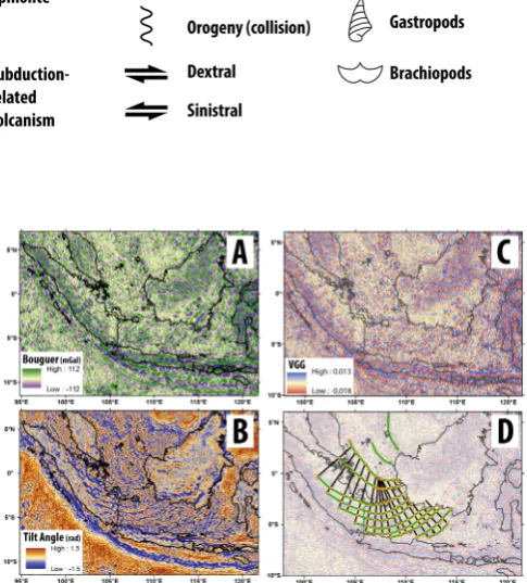
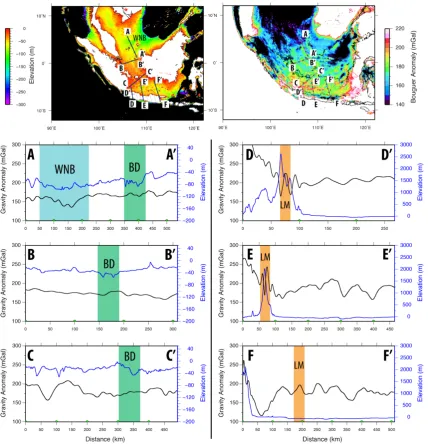
includ-Fig. 4. Band-pass-filtered (150 to 10 km) Bouguer gravity
anoma-lies (A) from the 1 min World Gravity Map (Balmino et al., 2012) highlight the large-scale structures and the curved lineaments on Sundaland, resulting from oroclinal bending as proposed by Hutchi-son (2010). Bouguer gravity tilt angle derivatives (B) and vertical gravity gradients (C) were derived from the Bouguer anomalies and were also band-pass-filtered (150 to 10 km) to remove noise from small-scale structures. The vertical gravity gradient was used as a guide to digitize the curved lineaments on Sundaland (green,
D). The Cretaceous Woyla, Luk-Ulo and Meratus sutures, along
with the Paleozoic Bentong–Raub suture, retain a strong signature of a lithospheric-scale discontinuity. Conversely, the Billiton De-pression is not observable as a generally north–south cross-cutting lithospheric-scale heterogeneity, and instead is likely to be a bathy-metric anomaly related to rifting in the West and East Natuna basins.
Table 2. Data and interpretations used for constructing plate motion model.
Region Feature Timing Dating method Interpretations based on
data and models from:
Australian NW Shelf Onset of seafloor spreading 155±3.4 Ma K–Ar of basaltic basement Gradstein and Ludden (1992)
West Sulawesi, East Java, Mangkalihat and easternmost Borneo
Late Jurassic rifting Shallow marine sandstones in Bantimala Complex
Late Jurassic ammonites, gas-tropods and brachiopods in Paremba Sandstone
Sukamoto and Westermann (1992) Wakita (2000)
Onset of seafloor spreading ∼158 Ma K–Ar of diorite, microgabbro and basaltic dyke
Polvé et al. (1997)
Collision with intra-oceanic arc ∼120 to 105 Ma (peak at∼115 to 11 Ma)
K–Ar from greenschists, blueschists and eclogites
Parkinson et al. (1998)
Suturing to southwest Borneo core
Late Cretaceous (∼80 Ma)
Stratigraphy, K–Ar and U–Pb of metamorphics, synthesis of previous studies
Wakita (2000)
Clements and Hall (2011)
New Guinea Rifting on northern New Guinea (Sepik)
Late Cretaceous Stratigraphic interpretations
Hill and Hall (2003) Pigram and Symonds (1991)
Papuan Ultramafic Belt crystalli-zation (Emo volcanics?)
Late Cretaceous (Maastrichtian)
Papuan Ophiolite emplacement interpretation from surface geol-ogy
Davies and Jaques (1984)
Emo metamorphics accretion, obduction and onset of north-dipping subduction along Sepik
∼35 to 31 Ma 40Ar/39Ar Worthing and Crawford (1996)
Sepik accretion to New Guinea 27 to 18 Ma K–Ar thermochronology Crowhurst et al. (1996)
Torricelli–Finisterre Arc accretion to northern New Guinea
6 Ma to present K–Ar thermochronology Crowhurst et al. (1996)
Sumatra and Sunda active margin
Woyla Group including oceanic plate, arc and carbonate assemblages
Late Jurassic to Early Cretaceous
Litho- and biostratigraphy, K–Ar ages of Sikuleh Batholith intruding Woyla Group (97.7±0.7 Ma)
Barber and Crow (2005)
Pre-Cenozoic subduction-related magmatic arc
264 to 75 Ma
(e.g., Sibolga Batholith)
K–Ar,40Ar/39Ar Cobbing (2005) McCourt et al. (1996)
Cenozoic subduction-related magmatic arc
65 Ma to present K–Ar Bellon et al. (2004) McCourt et al. (1996)
Eocene carbonate platforms Eocene to early Oligo-cene (pre-rift stage)
Stratigraphy De Smet and Barber (2005)
South China Sea Change from compressional to extensional margin indicated by emplacement of A-type granites
Cretaceous,∼90 Ma 40Ar/39Ar of ductile shear zones, U–Pb zircon ages of deformed plutons, Rb–Sr, K–Ar
Li (2000)
Onset of proto-South China rifting
∼65 Ma Onset of tectonic subsidence on South China margin
Lin et al. (2003) Yang et al. (2004)
Onset of proto-South China Sea seafloor spreading
∼59 Ma Supra-subduction zone ophiolites on Mindoro K–Ar dating of horn-blende separates
Faure et al. (1989)
Back-arc formation of proto-South China Sea
Paleocene Affinity of Sibuyan Ophiolite to Mindoro ophiolites
Dimalanta et al. (2006) Yumul et al. (2009)
Semitau affinity with South China
Table 2. Continued.
Region Feature Timing Dating method Interpretations based on
data and models from:
South China Sea Semitau (and Luconia–Balingian continent?) collision with northern Borneo
Eocene Inversion of regional basins Fyhn et al. (2010a)
Eocene (∼37 Ma) Sarawak Orogeny related to Sibu Zone uplift
Hutchison (2004)
Onset of rifting in the South China Sea
Eocene (∼37 Ma) Interpretations of seismic sections, stratigraphy and tectonic subsidence
Hutchison (2004) Briais et al. (1993) Lin et al. (2003) Yang et al. (2004)
Onset of seafloor spreading ∼32 Ma Magnetic anomaly identifications in the South China Sea
Briais et al. (1993)
Collision and attempted sub-duction of Dangerous Grounds–Reed Bank along northern Borneo (originating on South China margin)
∼17 Ma Sabah Orogeny Hutchison (1996)
Hutchison et al. (2000)
Collision of northern Palawan and obduction of ophiolites
Early Miocene Interpretations from stratigraphy and surface geology
Yumul Jr. et al. (2003)
subduction zones are tied to their overriding plate, whilst mid-oceanic ridges move at half stage rotations between the two flanking plates. Following initial user input, GPlates cal-culates the plate boundary intersections on the fly to result in resolved plate topologies that can be used to extract velocities and plate boundary configurations. Velocities were sampled from a 100 km-resolution mesh with equally spaced nodes to generate absolute plate velocity grids (Fig. 12b). The ab-solute reference frame underlying our global plate motions is a combination of a true-polar wander-corrected reference frame between 200 and 100 Ma (Steinberger and Torsvik, 2008) and a global moving hotspot reference frame since 100 Ma (Torsvik et al., 2008a). Tethyan spreading history has been revised following a re-interpretation of magnetic anomalies off the northwest Australian shelf (Gibbons et al., 2012) and the incorporation of rotations that account for full-fit reconstructions and continental deformation during rifting of Australia from Antarctica from∼160 to 83 Ma (Williams et al., 2011). Resolved topological plate boundaries, block outlines and model rotation files, along with animations of a hemispherical and regional view and digitized regional geo-logical features are included in the Supplement.
2.3 Plate kinematic considerations
We supplement geological evidence and previously pub-lished models with additional criteria of convergence rate thresholds across evolving plate boundaries and apply ge-ometric rules of triple junction closure. Firstly, no part of a purely synthetic plate (i.e., proto-South China Sea) is al-lowed to have velocities exceeding 25 cm yr−1, following the velocity threshold used by Stampfli and Borel (2002).
Fig. 5. Global Multi-Resolution Topography from Ryan et al. (2009) (top left) and gravity anomalies from Balmino et al. (2012) (top right)
with profiles through the West Natuna Basin and Billiton Depression (A, B and C), compared to the signature of the Luk-Ulo and Meratus sutures in the Java Sea (D, E and F). The Billiton Depression (“BD”) is not a large bathymetric anomaly of∼20 to 40 m relative to the surrounding Sunda Shelf. The Billiton Depression, often referred to as a Cretaceous-age suture zone (Hall, 2012; Metcalfe, 2012), does not intercept any emergent land, and therefore no suture rocks or related features (ophiolites, large-scale faults, etc.) have been reported, and does not exhibit a gravity signature that can be easily traced through Sundaland. Conversely, the Luk-Ulo and Meratus sutures (“LM”) on Java and eastern Borneo have well-documented exposures of suture zone material, exhibit up to a∼2500 m topographic anomaly (D) and can be followed in the gravity signature of the Java Sea (Bouguer anomaly of∼50 mGal). We therefore interpret that the Billiton Depression is related to the Oligocene onset of rifting in the West and East Natuna basins, and is not a pre-existing Cretaceous-age suture as proposed by Hall (2012). The location of the profiles is plotted on the bathymetry and gravity anomaly grids (top), and the grey lines represent additional profiles that are included as an animation in the Supplement.
2.4 Seismic tomographic constraints in the Cenozoic for the circum-Philippine trenches
Subduction polarities are inferred from subduction-related volcanism on the overriding plate. Additionally, seismic
mate-Fig. 6. Triassic and Jurassic fossil occurrences from the global Paleobiology Database (now Fossilworks), representing 24 fossil genera (30
samples from two locations), are found on Borneo within the Semitau continental block (orange). The paleobiological affinity between South China and this part of Borneo is significant during this time, suggesting that the Semitau continental fragment likely originated on the South China margin. The Natuna–Anambas Arc across central present-day Borneo represents the westward-dipping subduction zone that consumed the proto-Pacific, likely linked the east Asian volcanic arc (including the Fukien–Reinan Massif, modified from Honza and Fujioka, 2004) with the Schwaner Mountain granitoids in southwest Borneo. The age of the volcanics are at least Middle Jurassic, and likely indicate that the southwest Borneo core was part of Sundaland since at least the Middle Jurassic, and was unlikely a latest Jurassic Gondwanan allochthon. Although sampling of Indochina may be lower than of South China, the fossil occurrences do not indicate tectonic affinity between Indochina and Semitau (Borneo) during the Triassic and Jurassic. Paleobiological data from the global Paleobiology Database suggest that the Semitau block was along the South China mainland during the Triassic and Jurassic, and we interpret that it was rifted from this margin in the latest Cretaceous–early Eocene to open the proto-South China Sea in a back-arc setting. Nat-An – Natuna–Anambas Arc, WB – West Burma, WS – West Sulawesi.
rial are age-coded using constant sinking velocities following Hafkenscheid et al. (2006) and Zahirovic et al. (2012), and assuming near-vertical sinking of slabs following Van Der Meer et al. (2010). Two end-member slab sinking scenarios are applied, with a stratified mantle with 3.0 and 1.2 cm yr−1 sinking rates in the upper and lower mantle, respectively, compared to a whole mantle sinking rate of 1.4 cm yr−1 (Fig. 8). Although the assumptions of constant sinking veloc-ity and vertical sinking of slabs are an oversimplification, the age-coding technique offers a first-order insight to the sub-duction history, which we limit to the Cenozoic due to the
Fig. 7. The curved lineaments on the Sunda Shelf have been proposed by Hutchison (2010) to represent evidence of oroclinal bending of the
continental promontory. We digitize these curvatures from the vertical gravity gradient (Fig. 4) and use the lineaments to derive an oroclinal bending model for Sundaland. We partition the counterclockwise rotation of Borneo from 50 to 10 Ma following evidence of rifting in the Java Sea, and partition 50◦CCW rotation of Borneo from 25 to 10 Ma following the paleomagnetic constraints provided by Fuller et al. (1999). Not only does the oroclinal bending model restore the generally north–south strike of the east Asian active margin in the Cretaceous, it can also be used to restore the position of Belitung (Billiton) Island to be adjacent to Bangka Island, and hence restoring the Mid- to Late Triassic volcanic arc related to the Southeast Asian tin belt. Plate boundaries (MORs/transforms – blue, subduction zones – red) are plotted in a Sumatra-fixed reference frame. The Borneo core (yellow) is largely comprised of the Schwaner Mountains and related granitoids (red), which is used to sample the velocity field of Borneo’s motion relative to Sundaland. The positions of Borneo from Lee and Lawver (1995) are shown for comparison (green outline). See Supplement B for detailed steps for deriving the oroclinal bending model for Sundaland. BA – Bangka Island (violet), BE – Belitung (Billiton) Island (magenta), MP – Malay Peninsula, WS – West Sulawesi.
seismic velocity anomalies exceeding 0.2 % in P-wave mod-els are assumed to represent thermally perturbed mantle from subducted slabs, following the assumptions made by Van der Voo et al. (1999).
2.5 Oroclinal bending of Sundaland and the rotation of Borneo
Paleomagnetic data collected from Sundaland indicate that Borneo, Sumatra and the Malay Peninsula were likely po-sitioned in near-equatorial latitudes since the Cretaceous (Haile et al., 1977). Paleomagnetic studies have also iden-tified differential rotation between Borneo and the rest of Sundaland (Schmidtke et al., 1990; Fuller et al., 1999) and a rotation of Borneo up to 108◦CCW relative to stable Eura-sia since the Cretaceous (Schmidtke et al., 1990). The
Fig. 8. Plate reconstructions superimposed on age-coded depth slices of MIT-P (Li et al., 2008) seismic tomography with two end-member
motion between Borneo and Sundaland, or alternatively the rotation is a manifestation of internal continental deforma-tion of the Sundaland continental promontory. The model of Rangin et al. (1990) invokes rifting between Java and Borneo accommodated by a number of curved transform faults on the Sunda Shelf since the Eocene. The orientations of these transforms were based on the projection of small circles re-sulting from the opening of the South China Sea into the Sunda Shelf. These lineaments, much like in the Rangin et al. (1990) model, invoke some transform motion and panying internal deformation of continental crust that accom-modated oroclinal bending of Sundaland (Hutchison, 2010). These arcuate structures are similar to the curvatures of the Natuna and Anambas Cretaceous volcanic arcs (Fig. 6), and the Mid- to Late Triassic granitic arc from the tip of the Malay Peninsula running eastward and north of Sumatra into Bangka and Billiton islands. Importantly, Hutchison (2010) used observations from satellite data to infer the continuity of the curved lineaments on the Sunda Shelf and the Java Sea.
We extend this approach and show that parallel arcuate lin-eaments are clearly observed in gravity anomalies of Sunda-land, for instance in the 1-minute free-air gravity anomaly grid from the World Gravity Map (Balmino et al., 2012). Due to the high topographic relief of Borneo and other parts of Sundaland, and the necessity to track crustal fabric between emergent and submerged continental regions, we prefer to use the Bouguer anomaly model (Fig. 4) from the World Gravity Map to expose the tectonic fabric of Sundaland. We band-pass-filtered the Bouguer anomalies (Fig. 4a) to high-light large-scale features, and derived tilt angle derivatives (Fig. 4b) and vertical gravity gradients (Fig. 4c). The curved lineaments were used as guides (Figs. 4d, 7 and Supplement Fig. B1) to model the oroclinal bending of Sundaland. We as-sume that at some time in the past the curved lineaments were largely straight, much like those observed in north-western Sumatra. We assume that most of the oroclinal bending oc-curred in south-eastern Sumatra, the Java Sea and Borneo, where the concavity is the greatest, allowing us to keep north-west Sumatra fixed. Lines normal to the curved structures are digitized in a grid pattern from central Sumatra to the northern Java Sea (Fig. 4d). A rotation hierarchy is created for GPlates where the “normal guides” each move succes-sively relative to their western neighbor, while north-western Sumatra is held fixed as the anchor terrane (Supplement B, Supplement Fig. B1). This curved grid can therefore be used to restore the Sundaland Orocline much like straightening the bellows of a musical accordion (see Supplement B).
Since the Sunda Shelf between western Borneo and the Malay Peninsula records very little compression or moun-tain building (Daly et al., 1991), we assume that only exten-sion or minimal compresexten-sion can be accommodated on the Sunda Shelf since the Eocene. The “normal guides” (Fig. 4d, black) are rotated about a pole near the northern vertex of each normal guide to ensure no compression is implied go-ing forward in time, and each normal guide is rotated
inter-actively to derive finite Euler rotations in GPlates as to create a visual best fit with the straight portion of the Sunda linea-ments. Applying the accordion analogy, at this point the bel-lows are parallel to one another, resulting in lineaments that are largely straight. However, minor kinks in the restoration are inevitable largely because our oroclinal bending model is a simplification of a continuum of processes resulting in continental deformation across the entire Sunda Shelf. The rotations derived from undoing the curvature of the structural fabric are then partitioned between the onset and until the end of oroclinal bending. These timings are not well constrained, but end-member timings have been applied. Our preferred model invokes the onset of oroclinal bending from∼50 Ma, constrained by the onset of rifting in the Java Sea basins (Doust and Sumner, 2007) that we interpret as the onset of in-ternal continental deformation resulting from oroclinal bend-ing. The age-coded positive seismic velocity anomalies (in-terpreted as slabs) also support that the Java–Sunda arc was largely linear at∼50 Ma (Fig. 8). Oroclinal bending likely ceased by∼10 Ma, which corresponds to the end of Bor-neo rotation interpreted from paleomagnetic studies (Fuller et al., 1999), and is supported by the onset of basin inver-sion episodes in the Java Sea by∼13 Ma (Doust and Sumner, 2007) that indicate the end of an extensional regime on the Sunda Shelf. The paleomagnetic investigation by Fuller et al. (1999) also indicates that up to 51.8±3.7◦CCW Borneo rotation occurred after∼25 Ma based on the age of volcanic intrusions. Our model complies with these requirements, and therefore we partition 50◦ of CCW rotation of Borneo be-tween 25 and 10 Ma (Table 4, Fig. 7).
3 Plate tectonic model
Pale-Fig. 9. 3-D visualization of+0.2 % seismic velocity anomaly iso-surfaces in MIT-P (top) and+0.9 % seismic velocity perturbation in GyPSuM-S (bottom) models. Profiles A to G represent the vertical profiles (see Fig. 10) that capture the convergence and subduction histories of the region since the Cretaceous. Present-day coastlines are translucent grey shades, and present-day plate boundaries are translucent black lines. Slab volumes are colored by their depth, while the light blue color represents the interior surface of these slabs. PSCS – proto-South China Sea slab.
ozoic and Mesozoic metamorphosed basement intruded by melts derived from subduction of proto-Pacific oceanic crust in the Cretaceous (Katili, 1981; Charvet et al., 1994). How-ever, the recent models of Metcalfe (2011) and Hall (2011, 2012) argue for a Late Jurassic–Early Cretaceous origin of the Borneo core from northwest Australia. We present an al-ternative scenario for the evolution of the Sundaland core in the context of plate reconstructions linking the transfer of ter-ranes and the evolution of intra-oceanic subduction zones in the Tethyan and proto-Pacific domains.
3.1 Latest Jurassic rifting of terranes from northern Gondwana
Fig. 10. Vertical sections from MIT-P (Li et al., 2008) and GyPSuM-S (Simmons et al., 2009) seismic tomography models along profiles A to
Fig. 11. End-member pre-rift scenarios along northern Gondwana during the latest Jurassic (∼155 Ma) rift timing with a triple junction detaching the East Java, West Sulawesi, East Borneo and Mangkalihat from New Guinea driven by north-dipping subduction along the Woyla intra-oceanic arc representing the model implemented in this study (left). Alternatively, these blocks may have originated in the Argo Abyssal Plain (AAP), and a back-arc scenario may have existed along New Guinea (right), similar to the Incertus Arc proposed by Hall (2012). However, if this back-arc spreading did not detach continental blocks, then it may be the source for the proto-Philippine Arc. It is beyond the scope of this study to resolve whether the Mawgyi Nappes on West Burma or the Woyla Terranes on Sumatra contain microcontinental blocks, as it remains a continued source of controversy. We prefer the accretion of buoyant microcontinents in this region in order to account for the closure mechanism of the Woyla back arc in the Late Cretaceous. GAP – Gascoyne Abyssal Plain, PBE – proto-Banda Embayment, SNL – Sikuleh, Natal, Lolotoi and Bengkulu microcontinents. Schematic cross sections approximately follow dashed green line and are modified from Bouilhol et al. (2013). Not to scale.
described by Müller et al. (2001). The seafloor spreading on the NW Australian shelf created the proto-Banda Em-bayment, which also resulted in the abandonment of “para-autochthonous” continental fragments to form the Sula Spur (Audley-Charles et al., 1979; Hall, 2012; Norvick, 1979).
Although the seafloor spreading likely propagated from east to west along the margin, it is likely that a ridge–ridge– ridge triple junction was required in the Meso- and Neo-Tethys to link and accommodate northwestward separation of continental fragments from the NW Australian shelf and the simultaneous rifting on the New Guinea margin. The strike of the NW Australian margin, representing the latest Juras-sic rifting and subsequent seafloor spreading, is highlighted by the magnetic anomalies (Gibbons et al., 2013; Heine and Müller, 2005) and the reactivated structures on the conti-nental shelf (Keep and Harrowfield, 2005) with a northeast– southwest trending fabric. The New Guinea segment of the passive margin has not been preserved, but the outline of the stable part of the continent and the azimuth of
us-Fig. 12a. Present-day distribution of blocks and tectonic features (including oceanic basins, arcs and ridges) related to the long-term
conver-gence of the Eurasian, Indo-Australian and Pacific plates. Tectonic elements are color-coded by their tectonic affinities. The colors can help track the motion of tectonic elements through time in Fig. 12b and the animation in the Supplement. Grey shading is ETOPO-1 bathymetry (Amante et al., 2009). DR – Daito Ridge, WPA – West Philippine Arc, EPA – East Philippine Arc.
ing the seafloor spreading model of Gibbons et al. (2012). Although the Mawgyi Nappe obscures the basement rock, we assume that a Gondwana-derived terrane that supplied Timor with sediment from the northwest as interpreted by Metcalfe (1996) underlies this sedimentary cover, and is a westward extension of the contemporaneous, although con-troversial, microcontinental fragments found in the Sikuleh, Natal and Bengkulu areas on the Sumatra margin (Barber and Crow, 2003; Morley, 2012). We follow the model of Gib-bons et al. (2012) that invokes continental block detachment in the Argo Abyssal Plain at∼155 Ma (Figs. 11 and 12), and we assume that these blocks collide with the Woyla intra-oceanic arc to drive the closure of the associated back-arc basin by the Late Cretaceous (Metcalfe, 2006). However, we acknowledge that East Java, West Sulawesi and Mangkalihat may have originated from the NW Australian margin rather than northern New Guinea (Fig. 11), as discussed in more detail below. Our kinematic model implies largely
continu-ous subduction along the Sumatra and Java–Sunda trenches, with a∼10 Myr magmatic gap between∼75 and 65 Ma that can be accounted for assuming impeded subduction during the accretion of the Woyla Arc and obduction of ophiolites onto Sumatra (Fig. 3).
Fig. 12b.Plate reconstructions with colored blocks (middle), seafloor ages (left) and plate velocities (right). Northern Gondwana experiences a rifting event in the latest Jurassic
(∼155 Ma), and we implement the detachment of Argoland continental fragments, easternmost Borneo, East Java, Mangkalihat and West Sulawesi at this time. The embryonic
portions of the Philippine Arc are likely related to the easternmost portion of Tethyan seafloor spreading with supra-subduction affinities of latest Jurassic–Early Cretaceous volcanics. The intra-oceanic subduction system in the central Neo-Tethys (K-L, NT-BA), accommodating India–Eurasia convergence, also becomes established in the Early Cretaceous.
Gondwana-derived continental fragments begin to collide with the intra-oceanic subduction system in the mid-Cretaceous, and suture to Sundaland by∼80 Ma and to West
Burma/Sumatra by∼70 Ma. A pre-existing transform on the eastern margin of the Philippine Sea plate converts to a west-dipping subduction zone consuming Pacific crust by
∼55 Ma. Continued convergence of Indo-Australia with Eurasia results in the contact of the Sula Spur with the Java–Sunda trench by∼25 Ma. The Sepik composite terrane docks to
New Guinea by 27 Ma, followed by accretion of the Prince Alexander–Finisterre–Torricelli arc from 6 Ma. Subduction zones – magenta teethed lines, transforms/MORs – black lines, continental extent – grey, large igneous provinces (LIPs) – dark grey. AS – Asian Plate, EUR – Eurasian Plate, MT – Meso-Tethys, NT – Neo-Tethys, JP – Junction Plate, PMOL – proto-Molucca Plate, IZ – Izanagi Plate, PHX – Phoenix Plate, I-A – Indo-Australian Plate, ANT – Antarctic Plate, AUS – Australian Plate, IND – Indian Plate, GI – Greater India, LH – Lhasa, WB – West Burma, SUM – Sumatra, SWB – southwest Borneo, SEJ – southeast Java, SEB – southeast Borneo, SWS – southwest Sulawesi, LUZ – Luzon, N-S/PSP – northern/southern Philippine Sea plate, SS – Sula Spur, WR – Wharton Ridge, NT-BA – Neo-Tethyan back arc, K-L – Kohistan–Ladakh, WOY-BA – Woyla back arc, BAS – Barito Sea, MAW – Mawgyi microcontinent, CAP – Capricorn Plate, SNL – Sikuleh, Natal, Lolotoi and Bengkulu microcontinents, IZ-MP? – Izanagi microplate?, CP – Caroline Plate,
Instead, the model of Hall (2012) requires that up to 500 km of the Australian plate subducts beneath the Indian Plate, or vice versa, between 75 and 55 Ma. This is likely a result of the choice of Euler rotations representing Australia–India– Antarctica breakup, as well as the effects of plate circuits and absolute reference frames. The Hall (2012) model uses mo-tions of India and Australia based on the model of Royer and Sandwell (1989) that did not have the benefit of marine mag-netic anomaly data collected over the last 2 decades, while our model is based on compilations of more modern data and re-interpretations of marine magnetic anomalies (Gib-bons et al., 2013; Müller et al., 2008) and the considera-tion of continental stretching and deformaconsidera-tion during initial Australia–Antarctica rifting (Williams et al., 2011). As a re-sult, our model does not require any convergence between the Indian and Australian plates between 75 and 55 Ma, and in-stead seafloor spreading is accommodated on the now-extinct Wharton Ridge rather than the convergence required by the Hall (2012) model along the leaky I–A transform that cuts across the pre-existing tectonic grain of oceanic lithosphere. The model of Seton et al. (2012) and earlier incarnations, such as those presented by Gurnis et al. (2012) and Whittaker et al. (2007), portray continuous subduction of Neo-Tethyan oceanic crust along Java–Sunda, with the Wharton Ridge in-tersecting this margin in the early Eocene (Fig. 12b). Vol-canic arc rocks on Sumatra have been documented by Cob-bing (2005) with an age range of 264 to 75 Ma (namely the Sibolga Batholith in North Sumatra), with a subsequent pop-ulation whose ages range from∼65 Ma to recent times (Bel-lon et al., 2004), consistent with the synthesis of Sumatran volcanics by McCourt et al. (1996). Such data suggest that a magmatic gap along the Sumatra and Java–Sunda margin may have existed between∼75 and 65 Ma (Fig. 3), but not for the entire duration between 90 and 45 Ma as argued by Hall (2012). Subduction along the Java–Sunda trench in the Cenozoic established a volcanic arc, leading to the contin-ued accretionary growth of eastern Java since Eocene times (Smyth et al., 2007).
3.2 Cretaceous plate boundary configurations linking the Tethys and proto-Pacific
Reconstructing the proto-Pacific is notoriously difficult due to the lack of preserved seafloor with reconstructions relying on assumptions of symmetrical seafloor spreading where sin-gle flanks of the spreading system are preserved (Seton et al., 2012) or evidence of compression or extension that may be recorded in the geology of the overriding plate (Hilde et al., 1977; Johnston and Borel, 2007; Li et al., 2012; Ruban et al., 2010). Linking the motions of the Pacific Plate to the remain-ing plate circuit has also been a considerable challenge due to the added complexity of moving hotspots (O’Neill et al., 2005), ridge capture of plumes and the deflection of plume conduits resulting from mantle advection (Christensen, 1998; Tarduno et al., 2009), and the lack of preserved seafloor
spreading linking the Pacific to the Indo-Atlantic plate cir-cuit (Seton et al., 2012).
Two end-member scenarios exist that describe the link be-tween the easternmost Tethys and western Panthalassa. The model of Seton and Müller (2008) and Seton et al. (2012) requires a westward-dipping subduction zone that defines the boundary between Panthalassa and the Junction Plate, an isolated seafloor spreading system forming the eastern-most Tethyan domain. Alternative scenarios propose a con-tinuation of the proto-Pacific mid-ocean ridge system into the Tethyan oceanic basins (Audley-Charles, 1988; Hilde et al., 1977; Ben-Avraham, 1978). However, the westward-dipping subduction in the Cretaceous along eastern Asia (Seton et al., 2012; Hall, 2002; Hilde et al., 1977), imply-ing westward motion of the proto-Pacific seafloor, is kine-matically incompatible with northward-directed subduction of Tethyan seafloor along southern Eurasia without requir-ing a stable mid-oceanic ridge triple junction or a conver-gent boundary between the two tectonic domains. A mid-oceanic ridge triple junction would require numerous south-ward ridge jumps to maintain seafloor spreading across the proto-Pacific–Tethys oceanic gateway. We follow the model of Seton et al. (2012) where convergence between the proto-Pacific and the Meso-Tethys is accommodated largely by westward-dipping subduction along the Late Jurassic Junc-tion Plate in the eastern Tethys that formed as a back arc along northern New Guinea (Monnier et al., 2000) but was being subducted northward due to a reversal in subduction polarity by 155 Ma as represented in our model (Fig. 12b).
the Southeast Asia margin is asynchronous, with progres-sive accretions westward. Intra-oceanic collisions occur by 100 Ma in the Woyla segment (Fig. 12b), associated with the obduction of the Chin Hills and Naga ophiolites (Mor-ley, 2012), with renewed subduction and fore-arc emplace-ment likely forming the Andaman Ophiolite at 95±2 Ma in a suprasubduction zone setting (Pedersen et al., 2010). We invoke continuous north-dipping subduction of Tethyan oceanic crust following Guntoro (1999), to produce the large mid-mantle slabs interpreted in tomography (M/N-T, Figs. 9 and 10a–b) and previously described by Van der Voo et al. (1999). However, Morley (2012) invokes south-dipping subduction of Woyla back arc beneath Tethyan oceanic crust prior to collision of the continental fragments. We prefer con-tinued north-dipping subduction of Tethyan crust to produce slab pull necessary for the northward motion of the Indo-Australian plates, emplace Late Cretaceous granites on West Burma (Mitchell et al., 2012), while following the trend of subduction polarities in the central Meso- and Neo-Tethys proposed in previous studies (Aitchison et al., 2000; Ali and Aitchison, 2008; Van der Voo et al., 1999).
3.3 Intra-oceanic subduction in the Meso- and Neo-Tethys
The evolution of the Neo-Tethyan subduction zone along southern Eurasia has been a source of continued controversy as to whether this margin was a long-lived Andean-type mar-gin or whether it included back-arc opening and intra-oceanic subduction episodes (Aitchison et al., 2007; Aitchison et al., 2000; Zahirovic et al., 2012). Recent fieldwork has re-vealed remnants of Cretaceous intra-oceanic subduction in the Indus–Tsangpo suture zone (Aitchison et al., 2000; Davis et al., 2002; Ziabrev et al., 2004). However, plate motion re-constructions tend to differ in key areas, including (1) the subduction polarities, (2) the number of active subduction zones bounding southern Eurasia, and (3) the tectonic driv-ing forces related to the opendriv-ing and closure of the proposed back-arc basins. Previous studies argued for Shyok Suture (Karakoram–Kohistan) closure in the Late Cretaceous, be-tween 102 and 75 Ma, well before the approach of India to the Eurasian margin (Molnar and Tapponnier, 1975; Petter-son and Windley, 1985; Beck et al., 1995; Rowley, 1996; Bignold and Treloar, 2003) based on the review of Rehman et al. (2011). Subduction beneath Kohistan was interrupted between ∼95 and 85 Ma, and was replaced by arc rifting (Burg, 2011), suggestive of a new pulse of back-arc genera-tion in the Neo-Tethys at this time, much like the multi-phase back-arc generations in the Mariana Arc system on the east-ern margin of the Philippine Sea plate (Sdrolias and Müller, 2006; Sdrolias et al., 2004). The cessation of magmatism by∼61 Ma on Kohistan and paleo-latitude estimates from paleomagnetic data led Khan et al. (2009) to conclude that India first collided with the Kohistan Arc. Such a scenario would require the Shyok Suture to be closed sometime in
the early Eocene (Burg, 2011; Heuberger et al., 2007), much later than the established argument for Late Cretaceous su-turing. A recent isotopic study by Bouilhol et al. (2013) of granitoids on Kohistan and Ladakh indicated that the lead-ing edge of Greater India likely collided with this island arc at 50.2±1.5 Ma, while the Shyok Suture closed much later than previous estimates at 40.4±1.3 Ma, rather than in Cre-taceous times.
Table 3. The origin and present-day candidates for microcontinents that collided with the Neo-Tethyan intra-oceanic arc are controversial
and vary substantially across published models. We acknowledge that the easternmost Borneo, Mangkalihat, East Java and West Sulawesi may have originated from either the Argo Abyssal Plain or the New Guinea margin. However, we do not believe that the southwest Borneo core rifted from northern Gondwana in the latest Jurassic with these blocks.
Terrane Tectonic origin Accretion age Accreted to Reference
West Burma Argo Abyssal Plain Triassic Indochina Metcalfe (2011),
Hall (2012) This study
Argo Abyssal Plain Late Cretaceous Sibumasu Metcalfe (1994), Heine et al. (2004)
Mawgyi Intra-oceanic island arc Late Cretaceous West Burma Mitchell (1993)
Possibly underlain by Gondwana continental fragments colliding with an intra-oceanic arc
This Study
Sikuleh, Natal, Lolotoi Intra-oceanic island arc Late Cretaceous Sumatra Barber (2000)
Continental fragments Acharyya (1998),
Metcalfe (1996)
Southwest Borneo Argo Abyssal Plain Late Cretaceous Sundaland Metcalfe (2011), Hall (2012)
Northern Gondwana Early Permian This Study
Easternmost Borneo, Mangkalihat, East Java and West Sulawesi
Argo Abyssal Plain Late Cretaceous Sundaland Metcalfe (2011), Hall (2012), This Study
New Guinea This Study
3.4 The evolution of the Philippine Archipelago and Philippine Sea plate
The east and west Philippine Archipelago (EPA and WPA, Fig. 12a), forming the western boundary of the Philippine Sea plate, is a mosaic of ophiolite exposures (Encarnación, 2004; Pubellier et al., 2004), active and extinct volcanic arcs and is dissected by the sinistral wrench Philippine Fault (Fig. 1) that has been active since at least∼4 Ma (Barrier et al., 1991). However, evidence for wrench faulting in the Late Cretaceous also exists, suggesting an older pre-existing feature (Encarnación, 2004). To the east of the Philippine Fault, the archipelago and its northward continuation into eastern Luzon forms the active volcanic arc at which the West Philippine Basin is subducted along a west-dipping subduc-tion zone (Lee and Lawver, 1995). To the west of the Philip-pine Fault, dismembered ophiolites show suprasubduction zone affinities in the south, while in the area of Mindoro and Palawan, the ophiolites indicate more-precisely Eurasian suprasubduction zone affinities (Encarnación, 2004). There-fore, the archipelago holds vital clues on the geodynamic evolution of the east Asian margin and western proto-Pacific, and their link to the Tethyan tectonic domain.
The synthesis of Philippine and Luzon ophiolites by Encarnación (2004) suggests that a large portion of the
in age (Billedo et al., 1996; Encarnación, 2004) and may have formed as a result of subduction initiation and back-arc creation along the Calaguas ophiolitic crust (Encarnación, 2004). The Late Cretaceous ages of some Philippine ophi-olites mark the onset of volcanism associated with the for-mation of the Daito Ridge, Minami-Daito Basin and the Oki-Daito Ridge with an age range of∼85 to 49 Ma, while rocks in the vicinity of the Amami Plateau yield ages of∼85 to 60 Ma (Honza and Fujioka, 2004). Geochemical analyses of the rocks indicate that the Daito Ridge is a subduction-related arc feature, while the Oki-Daito Ridge has closer mid-ocean ridge basalt and seamount affinities (Honza and Fujioka, 2004; Matsuda, 1985; Tokuyama, 1995).
We follow the interpretation of Encarnación (2004) that eastern Luzon, the eastern Philippine Archipelago and at least Obi and Gag islands near Halmahera formed in a supra-subduction setting (i.e., back arc) initiating in the latest Juras-sic, consistent with earlier interpretations of pre-Late Creta-ceous Philippine Archipelago evolution (Geary et al., 1988; Geary and Kay, 1989; Karig, 1983) in the context of west-ern Pacific tectonic evolution and Philippine Sea plate for-mation between two opposing subduction zones (Jolivet et al., 1989; Deschamps and Lallemand, 2002; Honza and Fu-jioka, 2004; Queano et al., 2007). The growth of the Philip-pine Archipelago through cyclical back-arc opening through slab roll back, often followed by renewed compression and subduction of the back-arc oceanic crust, has resulted in the episodic obduction of ophiolite belts and the accretion of volcanic arcs, representing one of the fundamental mecha-nisms responsible for the accretionary growth of Southeast Asia (Pubellier and Meresse, 2013). We implement the origin of proto-Philippine Archipelago fragments in the vicinity of the northeastern Gondwana margin, related to the northward transfer of eastern Borneo, Mangkalihat, West Sulawesi and East Java (Figs. 11–12). This “proto”-Philippine Plate forms a back arc resulting from proto-Pacific slab rollback, opening between∼155 and 115 Ma (Fig. 12b). The collision of the West Sulawesi continental fragments with an intra-oceanic subduction zone at∼115 Ma ceases spreading in the proto-Philippine Plate. By 85 Ma, the west-dipping subduction polarity reverses, resulting in the subduction of the proto-Molucca and Philippine plates and the transfer of the newly formed fragments of Luzon, eastern Philippine Archipelago and Halmahera onto the Pacific Plate. North-east-dipping subduction along this margin produces the Daito Ridge and Amami Plateau crust, and progresses to back-arc opening to produce the crust older than Anomaly 24 (∼53 Ma, Fig. 1b) in the West Philippine Basin (SPSP, Figs. 12–13), largely fol-lowing the model proposed by Honza and Fujioka (2004) and Queano et al. (2007).
Intricately linked to the Cretaceous plate boundary be-tween the Tethys and the Pacific is the subsequent forma-tion of the West Philippine Basin in the earliest Cenozoic. Seafloor spreading in the central Philippine Basin initiated at Anomaly 24 (Fig. 1b,∼53 Ma), with a significant change in
seafloor spreading direction at Anomaly 20 (∼44 Ma) in the West Philippine Basin with active spreading continuing until ∼35 Ma (Hilde and Chao-Shing, 1984). Seafloor spreading ceased in the West Philippine Basin at this time, and west-dipping subduction along its eastern margin initiated back-arc opening of the Parece Vela and Shikoku basins along the Izu–Bonin–Mariana Arc from∼30 Ma (Sdrolias and Müller, 2006). Whether the Luzon terrane developed within or the periphery of the Philippine Sea plate has been controversial, with Hall (2002) implying an autochthonous origin on the east Asian margin while Deschamps and Lallemand (2002), Queano et al. (2007), Lee and Lawver (1995) and Milsom et al. (2006) prefer an allochthonous origin along a contin-uous East Philippine Arc, growing on the southern margin of the West Philippine Basin and resulting from northward-dipping Neo-Tethyan subduction. Onset of magmatism on Luzon is synchronous to magmatic episodes on Halmahera in the early Cenozoic (Queano et al., 2007), suggesting that much of Luzon was allochthonous to the east Asian mar-gin. Although not entirely conclusive, paleo-latitudinal es-timates suggest north-eastern Luzon was slightly south of the Equator between∼50 and 30 Ma (Queano et al., 2007), while Mindoro and western portions of Luzon and the west-ern Philippine Arc indicate east Asian affinities and a forma-tion autochthonous to the east Asian margin (Rangin et al., 1985; Yumul Jr. et al., 2003). We largely follow the model of Queano et al. (2007), Deschamps and Lallemand (2002) and Seton et al. (2012) for the evolution of the Philippine Sea plate, with both north-dipping subduction consuming the Australian Plate and southwest-dipping subduction consum-ing the Pacific Plate, to open the West Philippine Basin be-tween∼55 and 33 Ma. We invoke that a pre-existing trans-form fault on the eastern margin of the Philippine Sea plate converts to a subduction zone resulting from a change in rela-tive plate motions, triggering the onset of southwest-dipping subduction of Pacific crust at∼55 Ma. Northeastern Luzon forms on the Philippines southern intra-oceanic arc, while westernmost portions of Luzon develop on the east Asian margin in the vicinity of Mindoro.
Fig. 13a. Basins (shaded yellow) in Southeast Asia record significant tectonic events, which can be used to help refine timing of extensional
and collisional events in plate motion models. The dominant tectonic regime was age-coded to each basin through time following Doust and Sumner (2007). Rivers and lakes (thin dark blue) highlight the present-day drainage patterns. The 500 m bathymetry contour (thin light blue) is plotted for reference.
25 Ma, followed by 35◦CW rotation between∼25 and 5 Ma. Additionally, the paleomagnetic data indicate largely South-ern Hemisphere low latitudes in the Cenozoic (Hall et al., 1995a; Hall et al., 1995b); however, the data are confined to the southwestern extremity of the Philippine Sea plate in the vicinity of Halmahera. It is questionable whether Halmahera and nearby islands are part of the Philippine Sea plate, and therefore it is uncertain if the data collected in this region represents the rotational history of the entire plate. The syn-thesis of present-day plate boundaries using seismological
Fig. 13b.Regional reconstructions are plotted with seafloor age, continental extents, reconstructed present-day coastlines, LIPs, plate boundaries, velocities, age-coded basins and Borneo volcanics from Soeria-Atmadja et al. (1999). The proto-Izu–Bonin–Mariana (P-IBM) west-dipping subduction initiates by 55 Ma following a conversion of a transform to a convergent plate boundary to consume Pacific (PAC) crust. The proto-South China Sea (PSCS) opens as a back-arc basin from 65 Ma, with seafloor spreading initiating by 59 Ma that detaches the Semitau (SEM) and South Palawan blocks from mainland South China (SC). These blocks collide in the mid-Eocene with northern Borneo, resulting in the Sarawak Orogeny and cessation of north-west-dipping subduction of Izanagi (IZ) crust in this region. Subduction re-initiates at a south-dipping convergent margin along northern
Borneo by∼40 Ma to result in slab pull driving the rifting and opening of the South China Sea (SCS) from 37 Ma, with seafloor spreading initiating by 32 Ma and detaching
the Luconia–Dangerous Grounds–North Palawan blocks (DG) from South China. Continued subduction transfers these blocks to northern Borneo and South Palawan, resulting in
suturing, ophiolite obduction and the Sabah Orogeny by∼15 Ma. Borneo rotates counterclockwise by∼80◦since 50 Ma, of which 50◦CCW motion relative to Sumatra between
∼25 and 10 Ma. Basins were age-coded from Doust and Sumner (2007) and color-coded by their dominant tectonic regime, and indicate extension occurred in the Makassar Straits
between∼55 and 35 Ma, while the Java Sea basins largely experience extension between 35 and 25 Ma, followed by a period of quiescence and tectonic inversion (compression)
from∼15 Ma. The convergence of the Australian–Pacific–Sunda plates at present day has resulted in largely compressional regimes parallel to the Java–Sunda and Palawan trenches,
along with the basin inversion experienced in the Makassar Straits resulting from the collision of the Sula Spur (SS) with Sundaland. SIB – Sibumasu, IC – Indochina, MP – Malay Peninsula, SS – Sula Spur, SP – Sepik Plate, SEP – Sepik composite terrane, NG – New Guinea, ODR – Oki-Daito Ridge, PVB – Parece Vela Basin. All other label descriptions are
Philippine Sea plate due to the radially symmetrical magnetic field (see Torsvik et al., 2008b).
We use the paleomagnetic estimates from Hall et al. (1995b) and the seafloor spreading histories within the Philippine Sea plate from Müller et al. (2008) and Sdrolias et al. (2004), and then calibrate the subduction zone loca-tions on the periphery of the Philippine Sea plate with age-coded slab material for the Cenozoic (Fig. 8). We age-code slab material from a P-wave seismic tomographic model (Li et al., 2008), based on an assumption of constant sink-ing velocities, as a first-order estimate, in the upper and lower mantle, of 3.0 and 1.2 cm yr−1vertical sinking, respec-tively, following Hafkenscheid et al. (2006) and Zahirovic et al. (2012). This method is appropriate because the Philippine Sea plate cannot be linked to the Eurasian, Indo-Australian or Pacific plate circuits since the Eocene as it is almost en-tirely bound by subduction zones. However, we acknowledge that age-coding of slabs is likely an oversimplification as-suming vertical and constant sinking rates, where slab sink-ing rates are likely variable along-strike due to the oblique convergence vectors in this region (Sdrolias and Müller, 2006). We prefer the stratified mantle sinking scenario, with 3.0 and 1.2 cm yr−1 sinking in the upper and lower man-tle, respectively, compared to a whole-mantle sinking rate of 1.4 cm yr−1 (Fig. 8). The Java–Sunda trench has been less mobile than the trenches of the Philippine Sea plate, and therefore allows us to calibrate slab material in the seismic tomographic model with the trench locations in our plate mo-tion model. In contrast, the Philippine Sea plate is thought to have rotated by∼50◦between 50 and 40 Ma alone from paleomagnetic estimates (Hall et al., 1995a, b). Although the Java–Sunda trench has moved in response to the India– Eurasia collision, its motion in the Cenozoic is better con-strained through Eurasian plate circuits (Lee and Lawver, 1994, 1995). As a result, it justifies our choice to calibrate our sinking rate estimates to the Java–Sunda trench, and ap-ply it to fine-tuning the rotation of the Philippine Sea plate in the Cenozoic using positive seismic velocity anomalies in the mantle, as an additional constraint to paleomagnetic in-terpretations. The process of fine-tuning the rotations of the Philippine Sea plate, as a whole, involved superimposing the reconstructions and plate boundaries of Seton et al. (2012) on age-coded depth slices of the high-resolution P-wave model of Li et al. (2008). The finite Euler rotations were modified interactively in GPlates so that the reconstructed trenches co-incide with bands of fast seismic velocity anomalies, inter-preted to be slab remnants in the mantle. In doing so, we maintain the relative plate motions within the West Philip-pine Basin and the back-arc opening related to Izu–Bonin– Mariana rollback, constrained by preserved seafloor spread-ing histories (Gaina and Müller, 2007; Seton et al., 2012). By fine-tuning the absolute motion of the Philippine Sea plate, we attempted to preserve the convergence with the Indo-Australian Plate, while simultaneously accommodating the opening of the Parece Vela and Shikoku basins from the
roll-back of the Pacific slab, resulting in a west-dipping slab inter-preted in seismic tomography (PAC, Fig. 10d–g). Our result-ing model invokes CW rotation of the Philippine Sea plate between∼45 and 35 Ma, followed by little to no rotation between∼35 and 25 Ma, CCW rotation between∼25 and 15 Ma, followed by CW rotation to present day, which dif-fers from the estimates by Hall et al. (1995b). The CW ro-tation of the Philippine Sea plate between∼45 and 35 Ma in our model may be due to more rapid slab rollback of the (proto-)Izu–Bonin–Mariana subduction zone consuming Pa-cific crust relative to the trench rollback on the southern mar-gin of the Philippine Sea plate (Figs. 12b, 13b and anima-tions in the Supplement). Conversely, the CCW rotation be-tween∼25 and 15 Ma may be driven by faster rollback of the southern Philippine Sea plate subduction zone relative to the rollback of the Izu–Bonin–Mariana trench, likely accom-panied by more subduction of Philippine crust along the east Asia convergent margin. Testing alternative rotation histories for the Philippine Sea plate and the assumption of constant and vertical sinking rates applied to seismic tomography can be achieved with global numerical models of subduction, where the present-day prediction of slab material can be vali-dated using observations from a suite of seismic tomographic models.
3.5 The origin of the Caroline Plate
Mariana trenches (Fig. 1) with a back-arc origin of the Caro-line Plate from∼40 Ma (Hall, 2002). An alternative Pacific-origin model assumes that the Sorol Trough was Pacific-originally a fracture zone (Altis, 1999), with slab-pull-related tensile forces acting on the plate resulting in a tear of the Pacific Plate and initiating seafloor spreading to accommodate Car-oline Plate formation. The initial necking that led to rifting has also been suggested to be hotspot-related, to produce the gravitational and topographic anomalies of the Sorol Trough and the Caroline Ridge. The initiation of Caroline Plate sub-duction in the north-west along the Palau Trench and Yap Trough (Fig. 1), bounding the Philippine Sea plate, and the approach of the Caroline Plate with the leading edge of the Australian plate likely initiated the counterclockwise rotation of the Caroline Plate and the onset of seafloor spreading in the Ayu Trough from∼15 Ma (Gaina and Müller, 2007).
We largely follow the Hall (2002) and Gaina and Müller (2007) models for the Caroline Plate formation on the east-ern boundary of the Philippine Sea plate, but acknowledge that the Caroline Plate may have had a Pacific origin as pro-posed by Altis (1999). In our model, the Mussau Trench acts originally as a transform, and accommodates the rollback and seafloor spreading within the overriding Caroline Plate from ∼45 Ma, with west-dipping subduction consuming Pacific crust from∼25 to 4 Ma to accommodate convergence be-tween Pacific and Caroline seafloor (PAC, Fig. 10e). In the last 1 Myr, the Mussau Trench reversed subduction polarity to consume Caroline Plate crust at an east-dipping subduc-tion zone (Fig. 1, MUS in Fig. 10e). We model the origin of the intra-oceanic Torricelli–Finisterre Arc on the southern margin of the Caroline Plate, following Hall (2002), that col-lides progressively with northern New Guinea from∼6 Ma. An alternative interpretation, also consistent with the sur-face geology of the Cyclops Ophiolite (∼43 Ma boninites), is provided by Monnier et al. (1999), who advocate south-dipping subduction in the Eocene along northern Australia to account for the eventual accretion of arc material onto north-ern New Guinea. We prefer north-dipping subduction to gen-erate the northward slab pull required to open the Australian Southern Ocean, with the Cyclops Ophiolite generated in a fore arc along the young Caroline Plate.
3.6 Post-Late Cretaceous accretion and rift histories of the north New Guinea margin
The New Guinea margin, as the leading edge of the Aus-tralian continent, has undergone collisional and extensional episodes related to the complex convergence of Australian, Eurasian and (proto-)Pacific plates. The arc–continent col-lisions and accreted terranes on northern New Guinea have uplifted margin-parallel mountain chains and obducted ophi-olite belts (Baldwin et al., 2012; Abbott et al., 1994) (Fig. 1). Although no seafloor spreading history has been preserved between the core of New Guinea and the accreted terranes, a number of Cretaceous and Eocene sedimentary units record
oscillations between a convergent setting to an extensional passive margin, terminated by ophiolite obduction events (Cullen et al., 2012; Baldwin et al., 2012; Pigram et al., 1989). The youngest accretionary event is related to the arc–continent collision of the Finisterre–Torricelli terranes (Figs. 1, 12 and 13) with the New Guinean continental crust, beginning at ∼3.7 Ma in the northwest Finisterre Ranges and propagating towards the southeast (Abbott et al., 1994). The Ramu-Markham Fault (Fig. 1) that is the remnant of the north-dipping subduction zone between the accreted arcs and mainland is largely a strike-slip system on land, while its ocean-ward continuation to the east forms the active New Britain Trench along which the (proto-)Solomon Plate is being subducted (Baldwin et al., 2012; Cullen and Pigott, 1989). The Finisterre–Torricelli Arc likely formed at an intra-oceanic subduction setting on the southern margin of the Car-oline Plate, with the Finisterre volcanics yielding Oligocene to Early Miocene ages (Baldwin et al., 2012). In addition, Cretaceous-age plutons found in the Torricelli Mountains suggest that the arc system may be much older and over-printed by younger subduction-related volcanics (Cullen and Pigott, 1989). The Torricelli intrusive complex yields ages of 75 to 70 Ma based on K–Ar methods, followed by an Eocene episode of formation from between 42 and 18 Ma (Klootwijk et al., 2003). The volcanic data suggest that the Finisterre vol-canics are likely related to Caroline Plate origin of the arc, whilst the older Cretaceous-age plutons indicate that parts of the Torricelli Arc are related to an older convergent margin.
South of the Torricelli–Finisterre terranes, the Sepik ter-rane is the single largest accreted block representing an older collisional system with both continental and intra-oceanic island arc affinities (Klootwijk et al., 2003). Cooling his-tories derived from K–Ar thermochronology indicates that the Sepik terrane accreted to northern New Guinea between 27 and 18 Ma, while a later peak at 6 Ma likely represents the arrival of the Torricelli–Finisterre Arc at the margin (Crowhurst et al., 1996). The paleomagnetic model from Klootwijk et al. (2003) suggest that the composite Sepik ter-rane was at∼20◦S during the mid–late Eocene, along which Australian oceanic floor was subducting at a north-dipping subduction zone. We model the rifting of Sepik from New Guinea in the Late Cretaceous (from∼80 Ma), consistent with the Campanian–Maastrichtian (83.6 to 72.1 Ma) timing proposed by Hill and Hall (2003). The mechanism for this rifting is uncertain, with either slab pull from north-dipping subduction of the proto-Molucca Plate at an Asia–Pacific subduction zone or south-dipping subduction along Sepik re-sulting in back-arc opening and detachment of continental material. We prefer north-dipping subduction of the proto-Molucca Plate (Fig. 12b and PMOL in Fig. 10d–e), consis-tent with the contemporaneous northward subduction of the Neo-Tethyan oceanic crust.