(PLATES 33-42)
T HE past two years have seen the beginning of a large-scale excavation at ancient
Nemea under the auspices of the University of California at Berkeley. Since the first of these two years was devoted to cleaning and preparatory activities, the results of both years are presented together here.'
INTRODUCTION
The history of previous excavations at Nemea has been spotty and it may be appropriate in this first report to outline that history briefly. The earliest recorded visit to Nemea in modern times, and perhaps the occasion of the first modern excava- tion, was by a group sponsored by the Society of the Dilettanti in 1766. Richard Chandler wrote of that visit: 2 " We pitched our tent within the cell (sic), on the
clean and level area . . . a road . . . turns to the right to a village called Hagio Georgio, or St. George [now Nea Nemea], from whence we procured tools to dig, and wine, with other necessaries." Chandler does not state, however, whether the " tools to dig " were used or, if so, where.
1 It is customary at this point to acknowledge the assistance which has been received by an excavation project. The Nemea Excavations, however, have received so much assistance that it would be impossible to thank all those to whom we are indebted. On the other hand, our debt to certain individuals is so great that it must be stated. Among the academic community at the University of California, Berkeley, our gratitude must be expressed to Vice-Chancellor T. H. Chenoweth, Assistant Chancellor R. E. Erickson, Dean Sanford Elberg, and Professors D. A. Amyx, T. G. Rosenmeyer, and R. S. Stroud. Most of all, Chancellor A. H. Bowker has shown a confidence in the project which has been crucial to our success. In Greece, we have benefited from efforts on our behalf by the Director and Professor of Archaeology of the American School of Classical Studies, J. R. McCredie and C. W. J. Eliot, respectively; by the successive Inspectors- General of the Greek Archaeological Service, Professors S. Marinatos and N. Kondoleon; by the Ephor of Antiquities for the Korinthia and the Argolid, Mrs. E. Deilaki; by the mayor and secretary of the Community of Archaia Nemea, G. Argyropoulos and A. Mouscharas, respectively; and by the guard at the site of ancient Nemea, A. Vakrinakis.
The excavations have, to this point, been financed solely by private contributions and we would particularly thank for their support the Friends of Nemea Committee and its chairman, Mr. P. Manolis. Our benefactors are too numerous to mention, which does not diminish our indebtedness to them, but we are especially grateful for the support of Mr. J. Moore, Mrs. W. Perkins, Mr. R. Peterson, Mr. and Mrs. H. Selvin, Mr. and Mrs. B. Turner, and the California Alumni Foundation.
Three men have made our task at Nemea much easier; indeed, without their patient assistance our accomplishments would have been much less. Our special thanks go, then, to Ch. Kritsas of the Ephoreia of Antiquities for the Korinthia and the Argolid; to D. Kallis, Notary Public of Nea Nemea; and last, but by no means least, to P. Demetriou, mayor of Nea Nemea.
2 Richard Chandler, Travels in Asia Minor and Greece, HI, Oxford, 1825, pp. 286-287.
Hesperia, XLIV, 2.
American School of Classical Studies at Athens is collaborating with JSTOR to digitize, preserve, and extend access to Hesperia
>*gttDw|fl|t|X?| su|4X|"lu9t"*llmlltwIssslTnliHlml2gl~~~A | I It 0 I r I's IN'| I H I |4 I XI LI IN IC Jr | IQ I It IS IT IO IV I WIX
$1JI Ti |S |m | |1 | 1 er1 IID|g|% Ii yI0 S IJ,|I I tl I| I la 1 Ss2 I| TVIu I W,wv lww xIYIx |
tTI
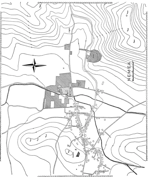
FIG. 1. Plan of Nemea valley. Shaded areas represent property purchased and ready for excavation. Lighter shading indicates areas purchased by the American
More than a century later the French School of Archaeology in Athens under- took excavations in 1884 in the areas of the Temple of Zeus and of a ruined chapel which lay over the remains of the early Christian basilica to the south of the temple (Fig. 1, Grid L,M 18). The inscriptions discovered in those excavations were pub- lished the following year.3 Again, in 1912, the French were responsible for a brief survey although it is not clear whether any actual excavation took place at that time. The results of that survey were not published until 1925 by which time the American School had begun work at Nemea.4
In 1924 the French School ceded its rights for Nemea to the American School of Classical Studies in Athens. That same year saw the first of three successive annual campaigns by the American School, sponsored by the University of Cincin- nati, and directed by B. H. Hill and C.W. Blegen.5 During these campaigns of 1924- 1926 excavations took place in the stadium, on the prehistoric ridge of Tsoungiza, in the Temple of Zeus and in the area to the south of the temple, and in a small area far east of the temple (Fig. 1, roughly Grid PP 10) where a late Archaic deposit was uncovered. Portions of the water channel on the east side of the race track in the stadium were exposed but filled back in again. Similarly a Neolithic " cave " and Helladic houses on Tsoungiza were investigated but covered over at the end of the excavations.
To the south of the temple a mound of debris, initially called the " Tomb of Opheltes," was excavated and found to cover an early Christian basilica which, in turn, overlaid a long early Hellenistic structure dubbed the " gymnasion " by the excavators (Fig. 2, Grid K,M 18). West of this building, after a gap of some 8.80 m. but continuing the same east-west line, a second ancient structure was discovered. Blegen termed it a " palaestra " and dated it to the fourth century B.C. A portion of the building contains a sunken chamber with eight bathtubs still in place (Fig. 2, Grid I,J 18).
Hoping to find the temenos wall of the sanctuary, the excavators extended a trench to the north of these buildings toward the Temple of Zeus. This trench revealed a large building measuring about 13 by 22.40 m. (Fig. 2, Grid K 16, 17). The identi- fication and function of the building were not apparent to the excavators.
The Temple of Zeus was also more fully uncovered and explored with several results including the discovery of the crypt at the west end of the cella and of evi-
3 G. Cousin and F. Durrbach, " Inscriptions de Nemee," B.C.H., IX, 1885, pp. 349-356. M. Clemmensen and R. Vallois, "Le Temple de Zeus a Nemee," B.C.H., XLIX, 1925, pp. 1-20.
5 See C. W. Blegen, " The American Excavation at Nemea, Season of 1924," Art and Archae-
s
C X _ _ _ _ __ X7tt _---T--<r-~~~~~~~~~~~~~~~~~~~~~~~~~~~~~~~~~~~~~~~~~~~~~~~~~~~~~~~~~~~~~~~~~~~~~~~~~~~~~~~~~~~~~~~~~~~~~~~~~~~~~~~~~~~~~~~~~~~~~~~~-- ---
6
t 8 _ _ _ _ _ _ r _
t__
_ _ <__
1 V _~~~~~~~~~~~~~~~~~~~~~~~~~~~~~~~~~~~~~~~~~~7
Z _ X _ _ _ -- ffi 2-1 R ' '| ' - '' -- t - -
t _ _ l t
-~~~~~~~~~~~~~~~~~~~~~~~~~~~~t __+ -|-||
|'| |A
1 |0 ID 0|!||__0
n3t__74$ t_ t _
4 ___t tl_-t__-t_t- z
t; t T tl - t t lt t t t t 1X- t ttt t lXt- 1 X Xt1;71 <~~~~~~~~~~~~~~~~~~~~~~~~~~~~~~~~~~~~~~1
4! <
1Ds
-
--T T -7 tt t _ vX _ __ _ _ 1 t~~~~~~~~~~~~~~~~~~~~~~~~~~~~~~~~~~~~~~~~~~~~~~1Is CtisEtllll|8t X--T |1
[ts C77t lB i I lU tL- Ct t lTl-X-L- 1 1 I < t P AINI
2 T _ _ T T __ l __~~~~~~~~~~~~~~~~~~~~~~~~~~~~~~~~~~~~~~~~~~~~~~~~~~~~~~~~~~~~~~~~~~~~
22 22--T -; -*
2t 3'-1- 23 7t__m
24 l24- -- -*-'--- _IIIII1
- 11-X X 111111m
3 _ 32 _-TTX
3~~~~~~~~~~~~~~~~~~~~~~~~~~~~~~~~~~~~~~~~~~~~~~~~~~~~27T = _r
23 tO7t t_t_t
JX T t__ -t 29
,30 Ttt _ -
36 <- - --
F2 32$F+= ==
A |8 C D | E: F G H | j KF|L | M | |
O
I
I
R Is S u v W 2 AA 53 B B c.c| b | EE | FF G|HH|it |JJ ;KK |LL |MM N R 0O | P Q |dence for the existence of an earlier temple. East of the temple a long narrow altar was uncovered. Unlike the trenches in the stadium and on Tsoungiza, these latter trenches were left open and the area around them purchased from the local land- owners. The result was an archaeological territory of some 12,000 square meters which was left for future exploration and protected from damage through farming activities (cf. Fig. 1). At the southwest corner of the area a small shed was built to protect the sunken bathing chamber in Blegen's palaestra. This shed has served for nearly half, a century as the depot for various and sundry antiquities discovered by chance at Kleonai, Phlious, and other sites near Nemea.
Throughout the decades of the 1930's, 40's, and 50's, Nemea received sporadic visits from scholars working on various aspects of the discoveries of the 1924-1926 excavations.6 Most notable among these were the visits for moving and measuring blocks from the Temple of Zeus by B. H. Hill and L. Lands in preparation for the publication of the temple. Nemea was otherwise left to comparative solitude which was broken again in 1962 and 1964 by investigations carried out under the direction of C. K. Williams, II. One of the most significant results of this renewed interest in Nemea was the appearance of the long awaited study of the Temple of Zeus by B. H. Hill as revised and edited by Mr. Williams.7 Another by-product of the renewed activity was the publication of the inscriptions which had been discovered during the excavations of the 1920's.8
During his work at Nemea in 1962, which was primarily devoted to the prepara- tion of the Temple of Zeus publication, Williams became interested in the buildings to the south of the temple, and in 1964 he returned to carry out more detailed investi- gations.9 These investigations uncovered parts of two more buildings south of the temple (Grid K, L 16), the baptistry of the basilica (Grid L 17), and the area east of the basilica (Grid N, 0 18); this last was purchased at that time and thus became a part of the archaeological zone. In this area the eastern end of the " gymnasion " was cleared and evidence discovered which suggested that the building ought to be identified as a hotel-like structure or " xenon." A kiln was also found beneath a part of the northern wall of the " xenon," together with evidence that the kiln had been used for the manufacture of the roof tiles for the fourth-century Temple of Zeus.'"
6 Mention should also be made of the inscribed bronze bull, found at Nemea in April 1927, which made its way to the University of Illinois museum; cf. H. N. Couch, " An Inscribed Votive Bronze Bull," A.J.A., XXXV, 1931, pp. 44-47.
7 B. H. Hill, The Temple of Zeus at Nemea, Princeton, 1966.
8 D. W. Bradeen, " Inscriptions from Nemea," Hesperia, XXXV, 1966, pp. 320-330.
C. K. Williams, "Nemea," AeXr., XX, 1965, Xpov., pp. 154-156; B.C.H., LXXXIX, 1965, pp. 705-707; "Archaeology in Greece," J.H.S., LXXXV, 1965, p. 9; A.J.A., LXVIII, 1964, pp. 201-202; A.J.A., LXIX, 1965, pp. 178-179; D. J. Geagan, " Inscriptions from Nemea," Hesperia, XXXVII, 1968, pp. 381-385.
After 1964, excavations at Nemea were once again halted, but this time for less than a decade.
1973
In the summer of 1973 work began at Nemea in preparation for large-scale excavations the following year, sponsored by the University of California at Berkeley.1' This work took the form of cleaning the area of the older excavations, surveying the valley, fencing, running a water line out to the site, and purchasing property in and around the sanctuary and the stadium from the local landowners.
The results of the latter activity can be discerned in the plan of the valley (Fig. 1) and summarized by the following statistics: in addition to the nearly 13 stremmata
(4 stremmata ca. 1 acre) already purchased during the past fifty years by the American School of Classical Studies, some 82 stremmata in the sanctuary and the stadium, and one stremma on Tsoungiza have been purchased outright, and the total area of the archaeological zone is thus about 96 stremmata, all of which are available for excavation. Another 46.5 stremmata, estimated as the area necessary to fill out the sanctuary and the stadium, are now under expropriation proceedings by the Greek Archaeological Service, since the owners of these properties refused to sell for a reasonable price.
Also during this period a warehouse owned by the local winegrowers' co-operative was rented and prepared to serve for purposes of cleaning, mending, and restoring, as well as for storage of the artifacts until a museum can be constructed at Nemea.12
Although most of the efforts during the 1973 campaign were devoted to prepara- tory work, it was to be expected that a few antiquities would appear. One such case occurred during the cleaning operations when a workman, instructed to remove only the modern silt, broke into an undisturbed ancient level near the southwestern corner of the " xenon." In a relatively small area (Fig. 2, Grid K/10-18/18; P1. 33, a)'3
measuring ca. 0.50 X 1.00 m. a pyre was found filled with bones, ashes, and pottery. Cut through by the south wall of the " xenon," the deposit provides at least a general terminus post quem for the construction of the building. Of the fifty catalogued
"- The staff consisted of Stella G. Miller and the undersigned who received much-appreciated assistance with the survey of the valley for three days from Professor and Mrs. Frederick Cooper and Mr. Michael Maa.B.
12 At the time of this writing (December 1974) it is a great pleasure to report that construction
on the museum is underway thanks to the generosity of Mr. Rudolph Peterson.
13 The system of grid reference used above and elsewhere in this and subsequent reports is
objects from this pyre 14 most were miniature vessels of a variety of shapes (P1. 33, b),
but one full-sized skyphos was discovered with the inscribed grafitto ATcrXvXtov on the base (P1. 33, d).'5 A fragmentary bronze strigil was also found, as was a bronze coin
of Sikyon (P1. 33, e), which is to be dated to the last third of the fourth century B.C.
Other activities during 1973 involved the recovery of antiquities lying outside the archaeological zone and transferral of those antiquities to the site. One such artifact was an inscribed block found re-used in a farmer's retaining wall some two kilometers north of the Temple of Zeus. This block (I 8, letter height 0.055-0.060 m.) preserves the letters AIDOAJAI (P1. 33, c) and can be securely identified with an inscription reported a century ago as then in the ruins of the chapel south of the Temple of Zeus.lG At some more recent period the block must have been moved to the spot where we recovered it, since it could not be found in the 1950's.17 Working from R6hl's sketch of the letters, Jeffery was inclined to date the inscription to the late sixth or early fifth century, and leaned toward a date in the decade of the 460's B.C. during a supposed period of control of the Nemean Games by Corinth, because the form of the epsilon on our stone is better known in Corinth than in the Kleonai- Phlious area." It should be remembered, however, that Nemea as a Panhellenic center might well produce the handiwork of citizens of many different areas of Greece with no necessary chronological implications. A more general date in the late Archaic period seems best for the inscription.
Already in his original publication of the piece, R6hl (footnote 16) had sug- gested that Ephodia should be understood as an epithet of Artemis or Hekate, and had read the tip of an iota preceding the epsilon of Ephodia. He interpreted this as the dative ending of the name of one of the female deities. A careful examination of the stone tends to support R6hl's interpretation since to the left of the lower tip of
14 Inventoried objects from the pyre: P 1-45; TC 1; M 1; BR 5; C 39. Uninventoried pottery
in lot 2.
15 P 1. Diam. 0.072 m. The actual spelling on the base of the skyphos is AIY'J'YAION. This
deviation from normal orthography is not common in the area of Nemea, nor of the Korinthia and the Argolid. It is common in other areas of Greece such as the north-central regions and the western and southern parts of the Peloponnesos. See L. H. Jeffery, The Local Scripts of Archaic Greece, Oxford, 1961, p. 79, Euboia; p. 89, Boeotia; p. 96, Thessaly; p. 99, Phokis; p. 104, Lokris; p. 183, Lakonia; p. 206, Arkadia and Elis; p. 248, Achaia.
16 H. R6hl, " Inschriften aus dem Peloponnes," Ath. Mitt., I, 1876, p. 229. The chapel will
have been one lying over the early Christian basilica at the south side of the sanctuary; cf. above, p. 145.
17 Jeffery, op. cit., p. 150, no. 7.
18 Ibid., p. 149. We might note at this point that the frequently repeated statement that Corinth
exercised control over the Nemean Games between 470 and 460 B.C. is based on the statement of the
R6hl's iota is the upper tip of a triangular letter, either alpha or delta. This reading would support a restoration of either ['ApTEUJ]8& 'Ebo8a'a or of ['EKaT] at 'Eo8tat. Unfortunately, the new reading does not provide any basis for choosing between these restorations, and it should be pointed out that other restorations are possible
such as [r] ab 'E+o8ia&.
Among the other antiquities gathered at the site in 1973, two deserve special mention. Both are Doric capitals (A 28, height 0.457 m.; A 32, height 0.464 m.) which share a common recent history in that both had been re-used in the courtyards of village houses as washing basins (Pl. 33, f, g). The tops of both have been hollowed out for this use and drain holes have been drilled down through the stone to exit in the middle of the echinus. Although neither capital can, at this time, be assigned to a specific building, it is clear that both imply the existence of monumental structures at Nemea other than the Temple of Zeus and the buildings known along the south side of the sanctuary. Unfortunately, both capitals were moved to the village houses so long ago that no one remembers their original place of discovery.
1974
Excavations at Nemea on a large scale began on April 15, just fifty years to the day after the excavations of the University of Cincinnati had begun, and extended until July 19, 1974, with an average work force of 60 local men and women.'9 For ease of record keeping and reference, the whole of the Nemea valley has been laid out in 20 meter grid squares (see footnote 13). Investigations in 1974 took place in parts of 15 different squares spread out over the valley ranging from the height of Tsoungiza on the west to the stadium on the east. This and subsequent reports will discuss activities by general topographical units subdivided into the grid squares investigated within each unit.
TSOUNGIZA
Although excavations on Tsoungiza did not form a part of our original plan for the 1974 season, a problem arose soon after our arrival which necessitated salvage
'9 The staff of the Nemea excavations for 1974 consisted of Darice Birce, Barbara Forbes,
Nicholas Jones, Marilyn Jones,-all of Berkeley- and James Wright of Bryn Mawr College as field archaeologists; Evelyn Bell of Berkeley as museum systems supervisor; Allan Steinau of Belvedere, California as architect; Lucy Weier of Athens as conservator; and Stella G. Miller as general co-ordinator. Herbert Abramson and Francesca L'Hoir of Berkeley and Katherine Kiefer of the University of California, Los Angeles, also served for a time as members of the staff. For their long hours of patient hard work, tolerance, and endurance, the above mentioned people deserve praise and have earned the gratitude of the undersigned. Our thanks also go to Joan E. Fisher of the Corinth Excavations for her preliminary identifications of the coins discovered in 1974.
operations and which indicates the necessity of continued excavations on the hill in the future. The southern end of the Tsoungiza ridge which lies some 600 meters west of the Temple of Zeus had been partially excavated in the 1920's (see footnote 5), but much remains to be done. The Neolithic material excavated half a century ago is now being published, thanks to the efforts of Professor J. Caskey, and a manuscript for the Helladic material is in the hands of Professor G. Mlylonas. One of the unfor- tunate results of this history is that Tsoungiza had never been declared an archaeo- logical zone. Thus, in early April of 1974 one of the land owners on the hill, Athana- sios Papadopoulos, deep plowed his field preparatory to planting, ironically, Cali- fornia grapes. Papadopoulos noted, during the plowing, many ancient sherds which he reported to us. We reported the situation to the Greek Archaeological Service and offered our assistance in salvage operations. After an inspection of the site, the Archaeological Service accepted our offer. We then completed negotiations with Papadopoulos for the purchase of his field, and began excavations.
The field is located in grid squares DDD, EEE-22, 23 and lies about 100 meters south of the Helladic settlement and about 35 meters southwest of the Neolithic " cave " excavated in the 1920's. It was soon discovered that the plowing had, in most places, gone right down to bedrock at a depth of 0.60-0.80 m. and had left traces in the form of long parallel grooves in the soft clayey stone (P1. 34, a). The plowed fill produced a few large stones which had been displaced by the plow, a large quantity of Neolithic pottery, fairly large amounts of Late Helladic pottery, and a small ad- mixture of modern horseshoes, plastic dolls, etc. Although no artifact from this fill could be assigned a stratigraphic significance, many could, be retrieved, restored, and inventoried. These include a three-legged strainer (P 75, H. 0.227 m.; P1. 34, d), painted bowls (P 77, H. 0.098 m., P 78, H. 0.122 m.; P1. 34, b, c), a ladle (P 85. H. of bowl 0.054m.; P1. 34, e), a cup (P 87, H. 0.047m.; P1. 34, f), a pyxis lid (P 92, H. 0.060 m.; P1. 34, g), a miniature terracotta throne (TC 11, H. 0.035 m.; P1. 34, h), a terracotta figurine (TC 10, P.H. 0.072 m.; P1. 34, j), a bronze dagger
(BR 17, L. 0.224m.; P1. 34, i), and stone tools (P1. 35, a: ST 6, L. 0.020m.).
Despite the destruction over most of the area which disturbed, on the basis of the artifacts noted above, Late Helladic levels,20 there were a few areas where ancient fill continued to a greater depth and had not been disturbed. Typical of these was a large amorphous pit of Early Neolithic date at DDD/4, 5-22/10, 11 which reached a maximum depth of only about 0.40 m. from the surface of the bedrock (367.90 to 368.28 m. above sea level). Having a maximum diameter of 1.90 m. and ending in
a shallow bowl-like depression, the pit was filled with dark brown soft earth, ashes, fragmentary bones, stone tools and blades, and many pottery sherds. The fill of the pit can be characterized by no better word than rubbish, and is reminiscent of the fill in the " cave " excavated by Blegen on Tsoungiza in 1925-26, although the bones discovered in 1974 did not appear to contain any human fragments.2" A respectable quantity of obsidian was recovered from this pit, consisting of fragments of blades, flakes, and cores (Pl. 35, b), together with two chert cores.22 Although time did not permit an exhaustive attempt at mending and restoring all the pottery, it was dis- covered that a few fragments from the undisturbed area of the pit join physically with fragments found on the surface of the field, and thus proved that the top of the pit had been disturbed by the plow as had been observed during excavation. A " rain- bow-ware " bowl (P 79, H. 0.073 m.; P1. 35, d), a black-ware bowl (P 80, H. 0.108 m.; Pl. 35, e), and two fragments of red painted ware (P 90, P.H. 0.144 M., P 91, P.H. 0.050 m.; Pl. 35, c, f) are representative of the ceramic contents of the pit. There are also coarse ware and a few sherds with plastic decoration in the form of low knobs. It is perhaps noteworthy that no incised ware and no whorls or beads were found in the pit.
In grid square EEE 23, which was only partially excavated since the square con- tinues into a neighboring field, three more Neolithic pits were discovered. None of these was completely excavated, but all showed the same basic characteristics as the pit in DDD 22 described above. One of the pits at the northwest corner of the grid square (EEE/1, 4-23/1, 3; P1. 34, a, right background), which ended at a depth of some 0.85 m. below the surface of the bedrock (+365.30 to +364.44 m.) but which extends further to the north in an unexcavated area, produced a variety of obsidian flakes and blades, chert cores, and several snail shells together with two lumps of rock crystal and a blue stone bead (P1. 35, g).23 Although the pottery from this pit is similar to that described above from DDD 22, none was inventoried since the excava- tions have not been completed.
All the material found in 1974 on Tsoungiza in a stratified context was, then, of the Early Neolithic period. This fact, plus the enormous quantity of the material, brings once again into focus a problem first defined by Blegen: 24 where is the Neo-
lithic settlement which is presupposed by such a quantity of material? The answer almost certainly lies buried further up the slopes of Tsoungiza, northwest of the area excavated in 1974, awaiting future investigations which will hopefully take place before agricultural activities in the area further damage the ancient remains.
21 Cf. C. W. Blegen, " Neolithic Remains at Nemea," forthcoming in Hesperia.
22 Deposit DDD 22:1. Obsidian: ST 40-63, 65-93; Chert: ST 64, 94.
23 Inventoried objects from Deposit EEE 23: 1: Obsidian: ST 28-30, 32-36, 113, 114; Chert.
ST 31, 115, 163; Rock Crystal: ST 37, 116.
THE SANCTUARY
Several areas of the sanctuary were tested in 1974, some devoted to shedding further light on problems already known from earlier explorations, some to the defini- tion of the boundaries of the sacred area. To the latter category belong the efforts far to the west, north, and east of the Temple of Zeus.
Section C 14
Within this square, located some 130 m. west of the temple, an L-shaped trench three meters wide was excavated along the northern and eastern sides of the square (Fig. 2). Although no architectural remains were discovered, several layers of a road surface came to light in the western end of the north arm of the L (P1. 36, a). This road appeared to run in a north-south direction and, on the basis of the small amounts of pottery discovered, probably dates to the Archaic period. It is clear that the road was out of use at least by the late Hellenistic period as confirmed by the pottery and coins from the level above the uppermost road surface.25 In this same Hellenistic level, along the eastern side of the east arm of the L (P1. 36, c), were discovered a series of holes evenly spaced. One of these holes, at C/18-14/19, con- tained several stones, one of which was found to be a fragmentary re-used inscription (I 12, P.H. 0.220 m.; P1. 35, h). Given the nature of the stone and the place of discovery which must, on the basis of the road mentioned above, be outside the sanc- tuary proper, there is a temptation to regard this as a boundary stone of the sanctuary. The small number of preserved letters seems, however, to preclude certainty of restoration.
Sections C 11, D 11, E 12, F 12
After the discovery of the road surface in Section C 14 as mentioned above, it was decided to excavate a series of trenches five meters wide and running in an east- west direction toward the temple from the line of the road on the west. The purpose of such a series of trenches was to discover the continuation of the road in C 14 and to attempt to define the limits and nature of the sanctuary on the west. The former objective was not realized and the road, if it does indeed continue to the north, must lie further to the west, perhaps under the modern dirt road. The search for the west- ern limits of the sanctuary was no better rewarded, at least in terms of a clear archi- tectural delineation. Sections C 11, D 11, and the western half of E 12 were void, of any manmade features with the exception of a double row of holes, about two meters apart, very similar to the holes discovered in Section C 14. Like the latter holes. those of Sections C 1 1, D 1 , and E 12 were in Hellenistic levels,26 and seemed to be running
25 Pottery from road surface: pottery lots 7-9; from layer over road: pottery lot 3.
28 Pottery from layers with holes in Section C 11: pottery lot 10; in Section D 11: pottery
toward the Temple of Zeus, although this impression may have been derived from the nature of the trenches which also ran basically toward the temple (P1. 36, d). The purpose of these rows of holes could not be ascertained although their shallowness and breadth led us to think of some planting or agricultural activity.
Sections C 11, D 11, and E 12 were not devoid of antiquities (note, for example, the fine bronze signet ring [GJ 2, H. 0.012 m.] from C 11, P1. 35, i), but the quantity and quality of the artifacts increased appreciably in the eastern end of Section E 12 and throughout Section F 12. Most notable was a layer of white clay, a significant increase in the quantity of tiles and stone rubble, and the 19 bronze coins from a single layer of Section F 12 (P1. 36, e)'27 Thus, even though the precise lines of the sanctuary cannot yet be exactly placed, it would appear that the westerfi limits of the sacred area are to be sought some 100 m. west of the Temple of Zeus.
Section F 4
The southern half of Section F 4 lies within a long narrow field which was deeply plowed in the spring of 1973. We then observed large fragments of ancient blocks, tiles, pottery, a complete miniature lekythos, and part of an Archaic inscrip- tion (I 6, P.H. 0.315 m.; P1. 36, b). These surface discoveries led to the conclusion that an ancient building ought to be in the area. Excavations in 1974 revealed, how- ever, that the ancient material had been re-used in a (property ?) wall which divided two areas of rectangular shallow trenches of the fourth century after Christ if not later (P1. 37, a).28 Similar trenches, which became familiar during the excavations of 1974 in other areas of the sanctuary (see below), seem to have been part of an extensive agricultural activity during the Byzantine period at Nemea. As was the case elsewhere, the farming trenches in Section F 4 contained much earlier material such as a bronze arrowhead (BR 3, L. 0.039 m.; P1. 37, b), a bronze crest attachment for a miniature helmet (BR 2, H. 0.026 m.; P1. 37, c), and a silver coin (C 132) from Argos (P1. 37, d). Such artifacts will have been churned up by the later farming activities which dug down into the early levels.
Beneath these Byzantine farming trenches in Section F 4 appeared four succes- sive layers of heavy road metaling all datable within the fourth century B.C. (P1.
37, e).29 Since the preserved uppermost layer had been disturbed by the Byzantine
farming, and since it was decided to delay excavation of the lower levels until more
27 Although these coins have not yet been studied exhaustively, a preliminary survey showed
none necessarily later than the late fourth century B.C. or the first half of the third century B.C.
28 Pottery lot 3; Coin 131. Although both the coin and the latest identifiable pottery belong
to the fourth century after Christ, our experience elsewhere in the sanctuary this year would lead us to believe that the farming activities in Section F 4 should be dated to the twelfth or thirteenth centuries after Christ.
of the area can be opened, the initial and final dates for the use of the road are, as yet, unknown. Given the position of the road and its basically north-south orientation, it is assumed for the moment that the road metaling is a part of a large road con- necting the sanctuary with the shore of the Gulf of Corinth to the north. Such a road must have existed in antiquity and is specifically implied by Perikles' erection of a commemorative monument at Nemea in 453 B.C. after his battle with the Sikyonians near the sea.80
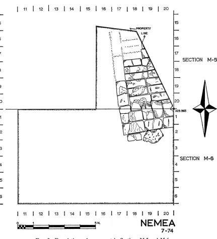
Sections M 5, M 6
Some 140 meters north of the Temple of Zeus, excavations in the eastern half of Section M 6 exposed part of a deep ditch running from southeast to northwest and filled with large quantities of debris (P1. 37, f). Averaging about 1.55 m. in depth, the ditch was in use during the thirteenth century after Christ as was clearly established by the presence of large amounts of Byzantine pottery which appeared in the bottom layer. Mixed in with this fill, however, were many earlier artifacts including a fine Aeginitan silver turtle (C 142; P1. 37, g). It is typical of these areas of Byzantine activity at Nemea that in stratigraphical association with the silver turtle there also appeared another silver coin of quite different date: a Frankish issue of Philip of Savoy (P1. 37, h). This ditch is clearly to be associated with irrigation activities for the Byzantine farm plots throughout the sanctuary area.
In the northeast corner of Section M 6 and the southeast corner of Section M 5 heavy foundations of a large monument were uncovered (Fig. 3, P1. 38, a). Since the foundations continue under neighboring fields, much of the monument remains unexcavated. It is evident that the north-south dimension of the foundations was at least 6.00 m. and the east-west at least 3.50 m. Due to the proximity of the modern surface, the foundations have suffered greatly and are preserved only to a height of two courses along the southern side, one course to the north, and in the area of the northwestern corner as exposed, the blocks have been completely robbed out. However, traces of depressions in the earth in this area ancl lines of working chips in neat rec- tangular patterns make restoration of blocks in this area certain. The blocks are of the same soft, yellow, poros limestone which make up the foundations of the " xenon " and the bath house on the south side of the sanctuary. As is also typical in the latter buildings, the blocks of the monument foundations are fairly well, but by no means precisely, cut and set in place.
Two blocks are set up against the south side of the monument foundations. The westernmost is of the same yellow poros and measures ca. 0.48 X 0.95 m., while the second is a hard, gray limestone with heavy natural weatlhering holes and measures
80 Plutarch, Perikles, XIX, 2.
11 | 12 | 13 | 14 | 15 | 16 j 17 i 18 19 20
15 15
PROPERTY LINE
16 16
17 17
SECTION M-5
8
t s
|18
19 g
20 20
I ~~~~~~~~~~~~~~~~~~~~~~~329.%G5
22
3
SECTION M-6
4
5 5
6
| 11 | 12 1 13 1 14 | 15 1 16 1 17 | 18 | 19 l 20 |
=
NEMEA
ca. 0.85 X 1.40 m. Although both blocks are obviously architectural accretions to the monument foundations, it was not possible to establish the chronological relationship between the blocks and the foundations in absolute terms, nor whether both blocks were set at the same time. It was also impossible to ascertain a destruction date for the monument, and the discovery of its superstructure must await future exploration. A general idea of the date of construction could, however, be derived from a small foundation trench next to the blocks and from a layer associated with the foundation trench and containing decomposed chips of the soft, yellow poros of the foundation blocks. Although the quantity of pottery from these layers was not large, it is clear that the monument cannot have been constructed earlier than the middle of the fourth century B.c., and a date in the late fourth or early third century is not precluded.32 Although there are many unanswered questions regarding these foundations, they do indicate that, by the early Hellenistic period, some construction associated with the sanctuary of Zeus existed 140 meters north of the temple.
Section N 12
The western half of this section, which lies directly east of the Temple and Altar of Zeus, was excavated in 1974. After clearing away tlhe fill dumped here in the 1920's and cleaning out two trenches excavated in that period, the most extensive remains of a Byzantine farming plot yet noted at Nemea were uncovered. Row after row of trenches, some 29 in number, were found. The dimensions of these trenches differed, with variations in the widths from 0.60 to 1.00 m., in the lengths from 2.50 to 4.00 m., and in the depths from 0.15 to 0.20 m. The fill within these trenches was predominantly of an earlier date, and built into a (property ?) wall between two rows of trenches was a fragment of an inscription of the early Hellenistic period (I 11, P.H. 0.089 m.; P1. 38, b). Perhaps more than any description, this fragment of a once much larger stele bears witness to the terrible destruction wrought over much of the sanctuary by the Byzantine farmer.
Beneath this layer of Byzantine farming trenches in Section N 12 appeared a series of five layers of compressed red soil which contained a minimum of pottery, but all apparently of Late Helladic date (see below), together with three stone blades
(ST 17-19; P1. 38, c. L. of largest, 0.036m.). Section M 12
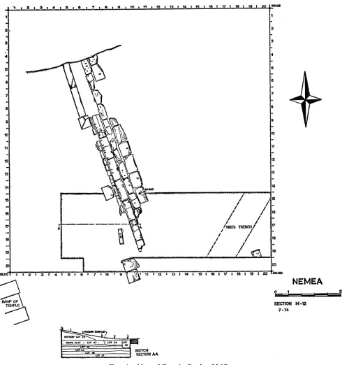
A trench along the southern side of this section and straddling the Altar of Zeus was excavated in order to recover information regarding the altar and the extent of the Byzantine farming of Section N 12 toward the west.
As uncovered during the excavations of the 1920's, the altar is a long,33 narrow
32 Pottery from foundation trench and construction layer: pottery lots 10, 11, respectively.
structure which consists of an outer row of relatively hard, gray limestone blocks, neatly cut and fitted, with a core of soft, yellow poros. The orientation of the altar is precisely aligned with that of the Temple of Zeus, but there is evidence of a change in the construction technique toward the northern end of the altar in an area not excavated in 1974. Along the western side of the altar there are apparent later accre- tions at intervals which consist of a long narrow curbing of soft, yellow poros and, further to the west, a series of rectangular blocks of hard, gray limestone at intervals along the west side of the altar. The trench cut across the altar in 1974 provided dates and explanations for some of these features, but much more work will be neces- sary to reveal the full history of this monument.
On the east side of the altar, after cleaning out a trench of the 1920's which ran diagonally through M 12, it was discovered that the farming activities had, indeed, run up against the east side of the altar and had been responsible for the removal and partial destruction of several blocks (Fig. 4). In the Byzantine levels were found, as usual, many artifacts of Archaic, Classical, and Hellenistic date, and two large worked blocks lying askew whose original purpose and provenience are unknown. Below the farming in most of the area were discovered the same compressed layers of red clay as those found in Section N 12 and likewise containing a few prehistoric sherds. Close to the disturbed blocks of the altar, however, remnants of undisturbed layers were found (P1. 38, d), but only one of these contained datable material. That layer yielded fragments of Archaic pottery which, although not susceptible of closer dating, can be placed in the second half of the sixth century B.C. This layer continues beneath the altar and thus provides a general terminus post quem for the construction of the altar in the latter half of the sixth century.
On the west side of the altar, between it and the ramp of the temple, the fill was found to be undisturbed. Here the modern surface sloped down toward the altar and covered a similarly sloping layer which extended toward, but did not reach, the altar. This layer consisted almost entirely, and to the exclusion of practically all earth and other artifacts, of large and small fragments of worked blocks. Nearly all these f rag- ments were of a hard sandy limestone, and in many cases displayed strong traces of burning. Several of the better preserved " had, on one surface, a fine white stucco which was covered by traces of an extremely fugitive blue paint. It was not possible to determine with certainty whether the blue paint was part of a pattern or of a solid painted surface. A few of the larger pieces also exhibited a band of anathyrosis with red pigment much in evidence (P1. 38, e: A 54, P.L. 0.475 m.). The red surfaces on
discovered during the excavations of the 1920's, but Williams restored the altar with a length of ca. 41 meters in Hill, Nemea, pl. 1. This restoration was based upon a reference to the discovery of the north end of the altar in one of the notebooks of the 1920's. Excavations in 1975 will attempt to determine the accuracy of that reference.
I * 2~ 3 ~ 4 1- 18 , 6 7_ lo.* 9 0 1 1!2- i 3 tw14 u15-16 1.- 17 1 1819 I _19 I 20 S*
1 1S
2. , _2
_ 3
4 ~~~~~~~~~~~~~~~~~~~~~~~~~~4
7 ~~~~~~~~~~~~~~~~~~~~~~~~~~~~7
10 1E
12 12
13 13
?4 ~~~~~~~~~~~~~~~~~~~~~~~~~~~~~~~~~~~14
15 /1
17 /10 TRENCH
is.a
TEWLE SECTION AZ-1
17 A /1~~~~~~~~~~~~~~O~~~~~ TRENCI4/ ~~~~~~~~~~~~~~~ -7
the smooth bands are to be associated with the use of PdX7o0 for anathyrosis on joint surfaces and the squaring of the blocks, a practice which is attested in several epi- graphic sources.35 It is of interest to note that the great majority of the fragments were from the corners of blocks. When one recalls the earlier material re-used in the foundations of the fourth-century Temple of Zeus,36 it is tempting to associate this layer with the reworking of blocks from the earlier temple for the fourth-century construction. The date of this layer is, then, of some significance. The relatively small area excavated in 1974 produced material which can be dated no later than the later fifth or early fourth century B.C.37 This seems much too early for the generally accepted date of the extant Temple of Zeus in the second half of the fourth century. Excavations in future years will, hopefully, resolve this apparent discrepancy.
Lower layers on the west side of the altar produced some important evidence for the chronology of the monument, but in an extremely complex stratigraphic con- text which can only be summarized here. A construction date for the altar of the late Archaic or early Classical period was indicated by the discovery of a layer (the same as found on the east) which ran beneath the altar and contained pottery of the later sixth century B.C. Two layers were found above this one and below the layer con- taining the fragments of worked blocks (see above). The lower of the two layers belongs to the first half of the fifth century B.C.; it produced a fragment of a lamp (L 4, P.H. 0.031 m.) with a large inscribed delta to the right of the broken handle attachment, and below this handle, in retrograde, the scratched letters Ato6[s] (P1. 38, f). The precise stratigraphic relation of this layer to the altar could not be de- termined as a result of later activities in the area to be described below. The upper of the two layers consisted of fine white clay, 0.25 to 0.35 m. thick, which must have been laid down deliberately as a paving surface. Although this layer had also been interrupted along the west side of the altar, its nature and elevation make clear that this layer has to do with the period of use of the altar. The ceramic contents of this layer, which included a fragment of a Pheidias-shape mug, belong to the second half, and probably early in the fourth quarter, of the fifth century B.C.38
Both the white clay layer and the layer immediately below it were cut into by two later trenches along the west side of the altar. The earlier of these was a shallow ditch some two meters west of and roughly parallel to the altar, which was filled with small burnt bone fragments, ash, flakes of carbon, and pieces of miniature votive vessels (P1. 38, g: P 54; P 55, H. 0.028 m.). The contents of this ditch are obviously to be characterized as residue from offerings at the altar, and can be dated to the late
35 R. Martin, Manuel d'architecture grecque, I, Paris, 1965, pp. 185-186, 197, provides a dis-
cussion of the practice and references to the ancient sources.
36 Hill, Nemea, pp. 3, 4, 27, et passim.
87 Pottery from layer of fragmentary worked blocks: pottery lot 23.
fifth or very early fourth century B.C. on the basis of a fragment of a Type 21C lamp and of two coins (C 155, C 156) found in the layer (P1. 38, h).39
The evidence presented above shows that the altar was constructed at the earliest in the late Archaic period, although a date in the early Classical period is not pre- cluded. The altar enjoyed heavy use at least into the early fourth century B.C.
Another period of activity around the altar was also documented in 1974. All the stratigraphic units described above (the white clay layer, the layer below the white clay, the votive ditch) were cut through along the wvest side of the altar by a trench bordering the west face. This trench measured some 0.60 m. in both width and depth, and was terminated at north and south by the large blocks which project from the west face of the altar. It will be noted that the yellow poros curbing stones which exist to north and south are not extant in the excavated area. Thus the trencl is to be associated with the robbing of the curbing, and perhaps with the placement of the large blocks along the west side of the altar. The date of the trench is clear from ceramic material of the early second century after Christ and from a fine example of a silver portrait coin of Trajan (P1. 39, a)." Since Pausanias relates that the roof of the temple had fallen in his day,41 it is surprising to find evidence of activity at the altar only a generation or so earlier. Hopefully, evidence will be found in the future confirming the early second-century placement of the stone bases, but the function of those bases can be suggested now. Just west of the altar and about midway between the two bases investigated this year, a voussoir block of an arch was found (Pl. 39, b). This block was upside down and embedded in the surface, and displayed no indication of ever having been moved. We might, tlhen, begin to think of the bases as supporting a baldacchino arrangement over the altar, set up in the earlv second century after Christ.42
Before leaving Section M 12, we should note that once again bits of prehistoric pottery and obsidian blades (P1. 39, c: ST 24, ST 25; max. L. 0.021 m.) were found in three layers which were below those described above.
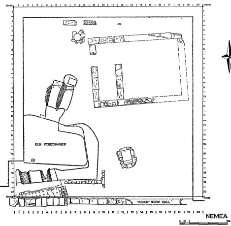
Section NA17
Lying some 80 meters south-southeast of the Temple of Zeus, Section N 17 adjoins the north wall of a part of the " xenon " and the kiln which was uncovered
3Pottery from " votive ditch ": pottery lot 24. Type 21C: R. H. Howland, Athenian Agora, IV, Greek Lamps, Princeton, 1958, pp. 48 f.
40 Pottery from robbing trench: pottery lot 25.
41 Pausanias, II, 15, 2.
42 Similar baldacchino arrangements, although usually dated much earlier than the date pro-
in 1964.43 Section N 17 was excavated with a view toward learning more about both structures.
The Byzantine activity in Section N 17 was as well documented as that observed elsewhere around the sanctuary, but the nature of that activity was somewhat different. No traces of the typical furrows or ditches were discerned. There can be little doubt, however, that the area was tied to agricultural endeavors since an iron sickle (IL 7; L. 0.229 m.) and an iron rake (IL 9; length of largest piece 0.177 m.) were found in the main Byzantine layer of the section (P1. 39, d, f). The date of this activity is well documented for, in addition to a relatively large if fragmentary quantity of pottery of the twelfth and thirteenth centuries after Christ, there were discovered more than 20 coins of which most belonged to the twelfth century, but which included a silver issue of Henry III of England from the thirteenth century (P1. 39, g).4
The Byzantine activity in Section N 17, including the digging for unknown purposes of a large circular pit at N/6, 8-17/11, 13, destroyed any Roman or late Hellenistic levels which might have existed in the area. We were fortunate to find, however, the level which served as the ground level outside the " xenon " and which covered several earlier monuments. The sandy-gravelly earth of this level contained loom weights, kiln separators, and pottery datable to the mid-third century B.C.4" The significance of the layer is that it provides both a date for the period of the " xenon " and a date for the destruction of the monuments which it covers. A brief description of these monuments would be in order at this point.
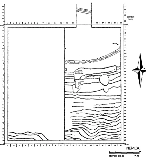
The whole of the southwest corner of Section N 17 (Fig. 5) was taken up by the kiln which had been partially excavated in 1964. As discovered at that time, the kiln consisted of a large rectangular (ca. 8.50 X 10 m.) firing chamber, later cut through by the north wall of the " xenon,'" with two arched passageways for stoking the kiln. These passageways were entered from the north at a subterranean level. The upper chamber of the kiln was apparently built of bricks, but most evidence had been removed with the construction of the " xenon." 4 Our first task was to re-
excavate the area uncovered in the 1960's (P1. 39, e).
Further exploration in Section N 17 to the north of the previously excavated area uncovered a large forechamber sunken to the level of the floor of the entrance passageways to the kiln (i.e. about 1.50 m. below the surrounding contemporary ground level). This forechamber is not yet completely excavated since it continues on to the west beyond the limits of Section N 17, but it appears to have been vaguely rectangular and to have measured about 5.80 m. in its north-south dimension. This
43 Williams, op. cit. (above, note 9); Hill, Nemea, p. 46.
44 Pottery lots 2-4; coin of Henry III: Coin 77.
45 Pottery from exterior ground level of " xenon ": pottery lot 7; inventoried objects: C 117-
119; P 57, 60; S 1; BR 25, 26.
I35 1 2 1 3 14 1 1 '6 7 j8g 91t101t11 12 1 13114 15 1 1617 18IS1 19 20 334445
2 ~~~~~~~~~~~~~~~~~~~~~~~~~~~~~~~~~~~~~~~~~~~~~~~~~~~~~~~~~~~~~~~~2
13 13
14
14~~~IL4
15 KILN FORECHAMBER---- -
113
2 3 4 :~816171 819 1 10 It1 12 1 U 1 14 1 15 1 1 17 IS8 19 1 0
NEMEA
-SCINN -17 7-74,
chamber was limited at its southeastern corner by a light wall constructed of roughly worked field stones, which is preserved for an east-west length of ca. 4.30 m. and a north-south length of ca. 1.80 m. Resting above the line of a dug earth scarp which forms the limits of the chamber on these sides, the wall may have had to do with a light superstructure marking the sides of the chamber. Although this wall seems rather light to have supported a roof, the stub of a stone colum-n found in situ at N/2, 3-17/17 would suggest that a roof did cover at least the southern part of the kiln forechamber.
Along the north side of the chamber, but set down at or near the level of the floor of the chamber, is a wall construction which clearly limits the chanmber on this side. Extending only for a distance of about 1.65 m. in an east-west direction, the wall consists of roughly squared poros blocks as a socle for both baked and unbaked mud bricks (P1. 40, a). Some 1.70 m. west of the west end of this wall is another stone for a socle, and in between these two features is an opening which leads to two firing chambers of another kiln. These chambers are roughly parallel and share a single opening into the forechamber as well as a common dividing wall ca. 0.60 n. thick. Constructed of mud-brick and rubble coated with a rough stucco, the width of each of the chambers is about 0.90 m. and both have the bottom of an apparent vaulting system preserved in stucco (P1. 40, c). Each chamber is slightly over 4 m. in length and each has a secondary floor which has not been tested. At the north end of the eastern chamber is a sunken pit, partially damaged by a Byzantine disturbance, about 0.75 m. lower than the upper floor of the chamber. The pit continues the line of the chamber and is about 1 m. long in a north-south direction. The floor and walls of this pit are coated with the same rough stucco which covers the walls of the kiln chambers, but the function of the pit is not immediately apparent.
The whole of the kiln forechamber, the new kiln chambers to the north, and a clay settling basin to the east (see below) were filled with a heavy debris of tiles, bricks, loomn weights, kiln separators (e.g. TC 14, P.W. 0.106 m.), and terracotta wedges (e.g. TC 15, H. 0.051 m.) for use in the kiln (P1. 40, b, d). Within this fill were large quantities of pottery which will require extensive study, but it is clear even at this point that the pottery covers a long time span, and continues through the fourth century and into the first quarter of the third century B.C. (P1. 40, e, f )." The
consequences of this new evidence are, first, that the construction date of the " xenon " must be placed well within the third century and, second, that the evidence discovered in 1964 which placed the closing of the kiln at ca. 320 B.C. must be reconsidered.48
Thus the tight chronology for the manufacture of the tiles for the Temple of Zeus must be loosened. Inasmuch as no new evidence for the construction date of the kiln
47 Pottery from kiln forechamber: pottery lot 26; Deposit N 17: 1. P 73, max. H. 0.068 m.
P 68, P.H. 0.049 m.
was discovered in 1974, the date provided by the earlier probes for the kiln con- struction and thus for a terminus post quem for the manufacture of the temple tiles at ca. 340 B.C. cannot be questioned.49 The terminus ante quem for the manufacture of the temple tiles, however, must be extended into the third century. This does not mean, of course, that a date in the 320's for the tiles and the temple roof is incorrect, but that such a date can no longer rest on the evidence of the closing of the kiln.
East of the kiln forechamber at N/i 1, 13-17/15, 17 the fill of the exterior ground level of the " xenon " covered a sunken chamber. Constructed of relatively large poros limestone blocks, the interior of the chamber is coated with a 0.025 m. thick layer of fine hydraulic cement (P1. 40, g, cf. P1. 40, c). The interior dimensions of the chamber at the top are 1.49 X 0.86 m., but the length at the bottom is reduced by two steps which descend into the chamber with an average tread width of 0.21 n1.
The riser height of the bottom step is 0.50 m., of the next step 0.45 m.; the heiglht
from the latter step to the top of the chamber wall as preserved is 0.24 m. This sug- gests that another course of stones, some 0.20 m. high, was cut off the top of the chamber when it went out of use and the " xenon " was constructed. Thus the pre- served depth of the chamber of ca. 1.20 m. should be restored to an original depth of about 1.40 meters with three steps of nearly equal height descending into the basin. The proximnity of this sunken chamber to the kiln complex, the close similarity of the earth fill in the chamber with that of the kiln forechamber, and the discovery of several kiln separators and loom weights in the sunken chamber suggest a func- tional connection with the kilns. The lining of hydraulic cement suggests the use of water, but the absence of water conduits and drains is disturbing, and the size of the chamber seems too smnall to be of much use as a water reservoir. A function is sug- gested by a thin layer of fine gray clay at the bottom of the chamber. From this discovery it is possible to think that the chamber was used as a settling basin for clay prepared for the manufacture of tiles and other terracotta objects in the kiln complex. A trench dug along the south and west sides of the settling basin provided incon- clusive evidence for the construction date, although a general date in the fourth cen- tury B.C. was apparent.5"
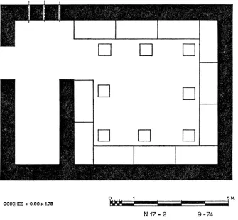
North of the clay settling basin a building was discovered which seems to be complete within the area of Section N 17 (P1. 41, a, b). The walls of the building, where preserved, are constructed of a single course of soft, white poros which served as both foundation and toichobate. The blocks of this course measure 0.60-0.70 X
1.20-1.25 m. and are 0.35-0.40 m. in height. Oriented in an east-west line, the overall dimensions of the building are 7.44 X 9.82 m. The interior of the building is divided into a smaller room or forechamber measuring about 1.90 X 6.10 m., on the west,
49 Ibid.
50 Pottery from fill of basin: pottery lot 14; inventoried objects: L 6; P 58; TC 13. Pottery
and a nearly square room to the east measuring about 6.10 m. on a side. On top of the poros foundation course of the south side are the remains of a rubble wall crudely constructed and perhaps serving as a socle for a mud-brick wall carried above. The foundations of the north and east walls of the building and, to a lesser; extent, of the south wall have been partially robbed out, and gaps in the west and in the interior wall may or may not be original. Three channels cut through the north wall near the west end are spaced about 0.50 m. apart and each is about 0.10 m. wide. It could not be determined if these channels were original in the construction of the building or a part of some later rearrangement.
The date when the building went out of use is clear from the fill of the exterior ground level of the " xenon " which has been discussed above. A date for the con- struction of the building has not been established conclusively, but a test trench ex- cavated between the western and interior walls yielded nothing later than the early fifth century B.C. Below the walls in this test trench was, as elsewhere in the sanc- tuary, a layer of prehistoric date.5"
The function of the building is unknown, and the fill which covered it, as it forms the ground level contemporary with the " xenon," provided no distinctive material toward the solution of this problem. Two possible suggestions can, however, be advanced. The first is that the building was a treasury. The general ground plan of the structure would be quite suitable with the columnar facade of an antechamber facing west and the larger " cella " behind. The- size of the building, although some- what large, is not inconsistent with that of other treasuries.52 The orientation and location of the new structure are, however, opposed to such an identification. Although treasuries might, due to the nature of the terrain, be oriented without apparent respect for the cult temple as, for example, on the Sacred Way at Delphi, the more natural orientation of treasuries is facing the temple as at Olympia and Delos. One would assume that the same was true at Nemea where the terrain makes no extraordinary demands and that treasuries will have faced the Temple of Zeus.53 Secondly, the existence of the kiln just to the south of the new building as well as the later, secular, "c xenon " argue that the whole of Section N 17 lies outside the sacred area of the sanctuary and thus outside the area where one would expect a treasury.
The second possible identification of the function of the new building in Section N 17 depends, in part, on the identification of the " xenon " as a place of dining and
51 Pottery from construction fill of new building: pottery lot 21. Pottery from lower level:
pottery lot 22.
52Treasury of the Athenians at Delphi: 6.90 X 10.03 m.; Sikyonians at Olympia: 7.31 X
12.80 m.; Treasury II at Olympia: 6.30 X 11.45 m.; Treasury III at Olympia: 6.57 X 12.85 m. ;
Syracuse (IV) at Olympia: 6.48 X 10.75 m.; Selinus (IX) at Olympia: 6.71 X 11.65 m.; Meta- pontum (X) at Olympia: 9.47 X 13.95 m.