GSJ: Volume 7, Issue 6, June 2019, Online: ISSN 2320-9186
www.globalscientificjournal.com
IMPLEMENTATION
OF
FISHERIES
MANAGEMENT
POLICY IN SUMEDANG DISTRICT JATIGEDE RESERVOIR,
WEST JAVA
Dea Nazihah1 , Atikah Nurhayati2, Titin Herawati2, Iwang Gumilar 2
1
) Students of the Faculty of Fisheries and Marine Sciences, Padjadjaran University
2
)Staff Lecturer of the Faculty of Fisheries and Marine Sciences, Padjadjaran University Fisheries Study Program, Faculty of Fisheries and Marine Sciences, Padjadjaran University
Jl. Raya Bandung - Sumedang Km 21, Jatinangor 40600 Email: dea.nazihah@gmail.com
ABSTRACT
This research aims to evaluate the application of fisheries sector management policies in Jatigede Reservoir, Sumedang District, West Java. This research was conducted in Jatigede Reservoir which inundated five subdistricts namely Darmaraja, Wado, Jatinunggal, Jatigede, and Cisitu Subdistricts in Sumedang District, West Java. The research was began in October 2018 until March 2019. The method used was the Likert scale and analyzed descriptive. The sampling technique used a purposive sampling method of 30 respondents. The selection of respondents is based on their ability background, interests, and have influence in their existence KJA in the Jatigede Reservoir, Sumedang District, West Java. Based on this results of the research, there are still infraction of Perda No 2 of 2012 article 49 paragraph 8 issued by the district government of Sumedang regarding the prohibition of aquaculture activities using floating net cages with an average index of 49.33%, and Perda No 2 of 2012 article 48 paragraph 5 concerning prohibitions to construct a building in protected areas (sempadan) Jatigede Reservoir with an average index of 60.5%. The solution needed is to make a spatial map of the Jatigede Reservoir area, impose sanctions if there are infraction, and execute socialization to the community regarding the prohibition on the construct a floating net cages and to construct a building in sempadan area of the Jatigede Reservoir.
INTRODUCTION
The Construction of the Jatigede
Reservoir submerged 5 sub-districts,
including the Jatigede District, Cisitu
District, Darmaraja District, Wado
District, and Jatinunggal District. This
reservoir has an inundation area of around
4,122 ha (41.22 km2) (BAPPEDA,
Sumedang Regency, 2013). The main
function of this reservoir is as an irrigation
facility covering 90,000 ha in the North
Coast region of West Java and also as a
hydroelectric power plant (PLTA) that is
capable of producing electricity with a
capacity of 110 mega watts, and providing
raw water with a capacity of 3,500 liters
per second for the area Sumedang,
Indramayu, Majalengka and Cirebon
(Setiawan 2017).
The Jatigede Reservoir currently
has functions in the fields of capture
fisheries, tourism, and power plants for
the surrounding area.Fishing activities in
the Jatigede Reservoir are used by the
surrounding community as a business
activity or source of livelihood. Fish living
in the Jatigede Reservoir contain nutrients
that are good for consumption as food
ingredients because they contain important
substances for the body such as protein,
fat, carbohydrates and different nutrient
levels for each species (Herawati et al.
2018). Regional Regulation No. 2 of 2012
article 52 is one of the policies issued by
the regional government of Sumedang
Regency which serves to maintain the
Jatigede Reservoir in its sustainability. The
regulation contains a ban on the existence
of inland aquaculture activities with
floating nets in the Jatigede dam area.
Fishing activities are permitted on
condition that they do not damage the
waters. In the regulation, the permissible
fishing activities are fishing activities in
the Jatigede Reservoir.
According to Mulyadi and Atmaja's
research (2011) it is recommended to
develop floating net aquaculture at
reservoir locations because the status of
reservoir water quality that is often
carried out by floating net cultivation has
a value of C which means that the quality
of waters for fisheries is low and does not
meet the specified threshold standards .
The presence of waste from leftover feed
can cause a decrease in water quality and
can also damage equipment or turbines.
The use of reservoirs as public waters for
KJA fish cultivation is principally permitted
as long as it does not exceed the
threshold limit of the reservoir area and
does not disturb the main function of the
reservoir as a hydroelectric power plant
The social problems found in the
construction of the Jatigede Reservoir are
quite complex, this is due to the length of
time between developments, however
various elements continue to work on
resolving these social problems.
Compensation issues, relocation
problems, panundung money problems,
social change problems from farming
communities to communities raising
freshwater fish continue to be handled
and resolved by the government, the
community, the private sector, and other
community elements (Purnama 2015).
The Jatigede Reservoir, which is
still in force for the cultivation of floating
net cages, appears new people from the
community who are cultivating floating
net cages. Survey results of the condition
of the Jatigede Reservoir in April 2018
there have been several floating net cages
established in the waters of the
Lewihideung area, and Marongbong.
Efforts to manage Jatigede Reservoir
require further planning and supervision.
The management aims to ensure the
functioning of the reservoir that remains
optimal and sustainable, management
activities must be emphasized in efforts to
secure the reservoir.
RESEARCH METHODS Time and Place
This research was conducted from January
to February 2019 which took place at the
Jatigede Reservoir, Sumedang Regency,
West Java.
Figure 1. Map of research sites Research Methods
The method used the case study
method(casestudy)described in descriptive
qualitative. The technique used in
obtaining data in this research is Purposive
sampling, this technique is used to conduct
interviews with respondents. Respondents
are limited to 30 people who have interests
and relationships with the floating net cage
activities such as KJA owners or KJA field
officers. The minimum number of
respondents is 30 respondents so that
homogeneous data is obtained. The type of
data used in this study are primary data
and secondary data, primary data obtained
from interviews with KJA owners or KJA
field officers in the Jatigede Reservoir.
Secondary data is data that is used by
and is obtained by reading or studying and
understanding through media such as
literature, books, documents, or scientific
articles related to the conditions in the
jatigede reservoir. Secondary data was
obtained from local regulation no. 2 in
Sumedang District 2012
RESULTS AND DISCUSSION
Implementation of local
regulations on the management of the
fisheries sector in Jatigede Reservoir was
influenced by the spatial plan of the
Jatigede Reservoir area itself. The spatial
plan for the Jatigede Reservoir has several
plans for regional spatial patterns, namely
protected areas (border), fisheries areas,
tourism areas, and district strategic areas
(KSK).
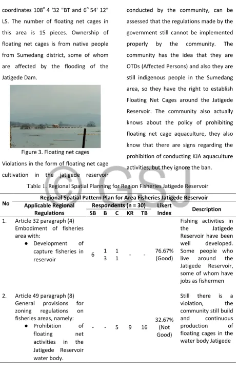
Implementation of Fisheries Areas
Locations found to have
committed violations by establishing
Floating Net Cages were in two locations,
the first location was in the Cibogo Hamlet
area, the second area was in Cipaku
Hamlet. The number of Floating Net Cages
built in Cibogo Hamlet, Leuwihideung
Village, Darmaraja Subdistrict, Sumedang
Regency at 108'24coordinateso 4"BT and
6o 54' 49" LS are 2 Floating Net Cages. Of
the two floating net cages in the field one
of the floating net cages is in the process
of being assembled. When asked about
licensing the construction of community
floating net cages answered that they
werethe indigenous people of Sumedang
and had the right to build and carry out
floating net cage cultivation activities.
Figure 2. Graph of Implementation of RT / RW Area Fisheries Jatigede Reservoir
The second location in the Jatigede
Reservoir which has a deviation from the
existence of a regional regulation
prohibiting floating net cages is Cipaku
Hamlet, Cipaku Village, Darmaraja
coordinates 108o 4 '32 "BT and 6o 54' 12"
LS. The number of floating net cages in
this area is 15 pieces. Ownership of
floating net cages is from native people
from Sumedang district, some of whom
are affected by the flooding of the
Jatigede Dam.
Figure 3. Floating net cages
Violations in the form of floating net cage
cultivation in the jatigede reservoir
conducted by the community, can be
assessed that the regulations made by the
government still cannot be implemented
properly by the community. The
community has the idea that they are
OTDs (Affected Persons) and also they are
still indigenous people in the Sumedang
area, so they have the right to establish
Floating Net Cages around the Jatigede
Reservoir. The community also actually
knows about the policy of prohibiting
floating net cage aquaculture, they also
know that there are signs regarding the
prohibition of conducting KJA aquaculture
activities, but they ignore the ban.
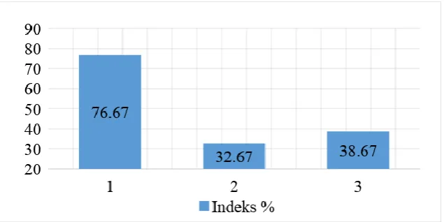
Table 1. Regional Spatial Planning for Region Fisheries Jatigede Reservoir
No Applicable Regional Regional Spatial Pattern Plan for Area Fisheries Jatigede Reservoir Regulations
Respondents (n = 30) Likert
Index Description
SB B C KR TB
1. Article 32 paragraph (4) Embodiment of fisheries area with:
● Development of capture fisheries in reservoir 6
1 3
1
1 - -
76.67% (Good)
Fishing activities in the Jatigede Reservoir have been well developed. Some people who live around the Jatigede Reservoir, some of whom have jobs as fishermen
2. Article 49 paragraph (8) General provisions for zoning regulations on fisheries areas, namely:
● Prohibition of floating net activities in the Jatigede Reservoir water body.
- - 5 9 16
32.67% (Not Good)
3. Article 52 paragraph (4) the general provisions of zoning regulations for the development of hydropower Jatigede pay attention:
● Activities that are permissible for inland aquaculture activities provided that they do not damage the waters or turbines and other water bodies ● Prohibition of land
aquaculture
activities with floating nets
- - 7 14 9 38.67% (Poor)
One of the functions of the Jatigede Reservoir is generator
hydropower (PLTA) but there are still violations by conducting floating net cages in the Jatigede Reservoir water body. The government has installed signs in the reservoir border area which contain restrictions on conducting
cultivation with floating net cages.
Imimplementation of Protected Areas
Installation of signs around the
Jatigede Reservoir is one form of the
government to disseminate to the
surrounding community both the Jatigede
Reservoir community and the people who
visit the Jatigede Reservoir area. The
signaling of the signs can be seen in Figure
2. In the signs, several activities are
prohibited in the protected area (border)
area of the reservoir. Prohibition is
written in the beacon are:
1. Dilaranganya building Area area
protected area (border) reservoir
2. banning activities of making and
memasangan floating net (KJA)
3. Dilarangan activity of farming
4. Dilarangan sell
5. Dilarangan swimming and fishing
in hazardous areas
6. is prohibited littering
7. Dilaranganya logging operations
Figure 5. signs Prohibition of activities in Jatigede
Figure 4. Graph Implementation of RT / RW Areas Protected Jatigede Reservoir
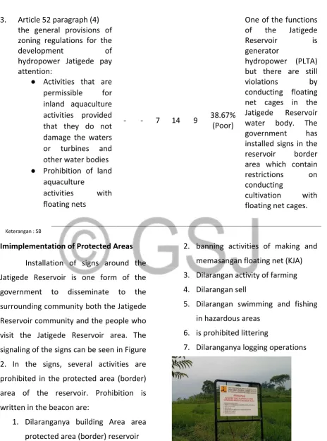
Table 2. Spatial Planning for Protected Areas in Jatigede Reservoir
No
Plans for Regional Spatial Patterns for Protected Areas Jatigede Reservoir Applicable Regional
Regulations
Respondents (n = 30) Likert
Index Description
SS S C KS TS
1. Article 26 Paragraph (1) Explain that the area around the reservoir is one of the protected areas
- 5 1
2 12 1
54% (Enoug
h)
Performed installation of signs in the lake border area, but there are still people who build buildings around the reservoir boundary 2. Article 26 Paragraph (3)
Explain the area protected area around the reservoir at least 50 (fifty) meters from the highest tide point to the land in the Jatigede
Reservoir which inundated Jatigede, Wado, Jatinunggal, Darmaraja and Cisitu
Subdistricts of
approximately 827 (eight hundred twenty seven) hectares
5 1 5
1
0 - -
54% (Enoug
h) The
government makes a map of RT rw which in it explains that the area within 50 meters of the highest tide point of the reservoir is a lindu area ng or border. Rt rw map can be found in annex
3. Article 44 paragraph (1) The realization of priority protected areas referred to in the following activities:
● Installation of signs / warnings to areas
- - 7 11 12
76 , 67% (Good)
has been carried out Installation of signs and
prone to disaster / disaster mitigation ● Determination and border protection reservoir
● water tourism development
signs can be seen in the picture, but early warning signs for disaster-prone areas have not been found.
4. Article 48 (5) of
the general provisions of zoning regulations
established by considering the reservoir border:
● Utilization of border space reservoirs for green open space ● structure
development of natural and artificial structures to prevent landslides / soil erosion and maintain water bodies form a reservoir / lake ● border width
determination of reservoir / lakes in accordance with the provisions of laws and regulations ● Prohibiting the
establishment of buildings in addition to the management of water bodies, water use and supporting recreational functions ● Restricting the
establishment of buildings, namely only for the management of
4 1 4
1
2 - -
36.67% (Poor)
This article has been well implemented by the government, but the
water bodies and water utilization.
5. Article 49 Paragraph (3) The provisions of logging allowed distance is more than 500 meters from the edge of the reservoir
3 1 5
1
2 - -
74.67% (Good)
None activities ofloggingwithin less than 500 meters from the edge of the
Jatigede Reservoir
Implementation of Tourism Areas
Implementation in the field the
government has moved cultural heritage
so that the cultural heritage is not lost.
One of the cultural heritage that has been
transferred by the government of
Sumedang Regency is a cultural preserve
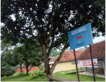
called the Candoli Site located in Cisurat
Village, Wado District, Sumedang Regency
at coordinates 108 ° 5 '6 "BT and 6 ° 56'
28" LS. It can be concluded that the model
that has been made does not experience
correlation.
Figure 7. Candoli Site
of Sumedang Regency at coordinates 108o
4 '14 "BT and 6o 52' 19" LS. The
development of this tourist area is in
accordance with regional regulation No. 2
of 2012 where the construction of tourist
areas does not disturb the protected area
(border) of the reservoir, which is not built
in protected areas, and in its construction
in accordance with the culture around the
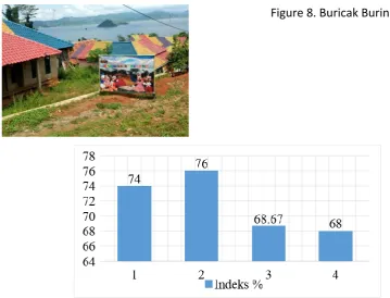
Jatigede Reservoir. Masayrakat who lives
in the village "Buricak Burinong" is a
community that was previously a victim of
the flooding of the Jatigede Dam, but they
used the money from the compensation
of flooding by creating a new village. The
development of the village "Buricak
Burinong" was also assisted by the
government
Figure 8. Buricak Burinong Village
Figure 6. Graph of Implementation of RT / RW Areas Tourism Jatigede Reservoir
Table 3. Regional Spatial Planning for Areas Tourism Jatigede Reservoir
No
Regional Spatial Pattern Plan for Areas Tourism Jatigede Reservoir
Applicable Regional Regulations Respondents (n = 30) Likert
Index Description
SB B C KB TB
1. Article 35 Paragraph (2) It is explained that the submergence of submerged sites is carried out Jatigede Dam
3 1 5
1
2 - -
74% (Good)
Site which was
submerged by the Jatigede Reservoir has been
relocated by the
government 2. Article 35 Paragraph (4)
Explains that the Jatigede Reservoir is developed for
artificial tourism activities 4 1 6
1
0 - -
76% (Good)
community, one of which the
construction of the village "Buricak Burinong" which is a village built by the OTD Jatigede Dam
3. Article 44 paragraph (7) The realization of the tourism area is prioritized on activities:
● Transfer of cultural reserves to be flooded Jatigede Reservoir
- 1 3
1
7 - -
68.67% (Good)
The transfer of cultural preserve submerged by the Jatigede Reservoir has been carried out
4. Article 49 paragraph (11) General provisions of zoning regulations on tourism areas pay attention to:
● Prohibited activities and buildings that interfere with functions from the tourist area itself, except for the opportunity to relocate.
● Activities and establishment of buildings around the Jatigede Reservoir are limited, only for the benefit of tourism activities in the Jatigede Reservoir Jatigede ● Reservoir can be utilized
by the natural and cultural potential of its community
● Tourism activities carried out in Jatigede Reservoir
68% (Good)
do not disturb the function of protected areas
● Growth of tourism supporting facilities and infrastructures which is around the protected area of Jatigede
Reservoir, especially in the area of water absorption
● Past cultural heritage sites and historical heritage around the Jatigede Reservoir are protected
● Do not change or damage the shape of local architecture, landscapes and visual views
was built by the OTD community from flooding the Jatigede Dam.
Ket : * Real at the 5% level of
District Strategic Area Implementation
Viewed from the viewpoint of
economic interests, the Jatigede Reservoir
is also a Strategic District (KSK) supervised
area. According to Bappenas (2016) the
strategic area of the regency area is a
region whose spatial planning is
prioritized, because it has a very
important influence in the scope of the
district on the economy, social, culture
and environment. The District Strategic
Area (KSK) has the following functions:
1. Develop, preserve, protect, and
coordinate the integration of the
development of the region's
strategic values in supporting
urban spatial planning
2. As a space allocation for various
socio-economic activities of the
community and environmental
conservation activities in the
assessed regency has a very
important influence on the
relevant district area.
3. To accommodate regional spatial
planning that cannot be
accommodated in the structure
plan and spatial pattern plan.
4. As a consideration in formulating
indications of the main program of
the RT / RW
5. district.
Table 4. District Strategic Area Spatial Planning (KSK) Jatigede Reservoir Sumedang Regency
Planned Spatial Pattern for District Strategic Areas (KSK) Jatigede Reservoir
Regional Regulations that
Apply
Reponden (n = 30)
Likert Index Description
SB B C B TB
Jatigede Reservoir Area includes the district's strategic area is explained in article 39
paragraph (1) Jatigede Reservoir including the district strategic area from the point of interest of economic growth
5 1 4
1 1
- -
76% (Good)
Jatigede Reservoir including the regency strategic area (KSK) because it is assessed that the Jatigede Reservoir can have very important
influence in the scope of the district on the economy
Conclusion
Based on research conducted with
the actors of floating net cage aquaculture
in the Jatigede Reservoir it can be
concluded that there is still no regulation
regarding the spatial plan for the Jatigede
Reservoir, implementation of Perda No. 2
of 2012 article 49 verse 8 concerning
Fisheries in the Jatigede Reservoir area are
still available budgeting is that by carrying
out floating net cage cultivation activities
that have actually been determined that the
activity is prohibited, the community has
the opinion that they have the right to carry
out aquaculture activities using floating net
cages, but have an average index value of
49.33% or have sufficient interpretation
value. The implementation of protected
areas in the Jatigede Reservoir still has
violations, namely by the existence of
communities that build buildings around
protected areas (borders) that have been
banned in Perda No 2 of 2012 but have an
average index value of 60.5% or have
good interpretation values . The tourism
area has an average index value of 71.67%
or has a good interpretation value and the
district strategic area (KSK) has an
average index value of 76% or has a good
interpretation value, no violations are
made from the rules that are inRegulation
No. 2 of 2012.
REFERENCES
RegionalBAPPEDA. 2013. Guidelines for
Sectoral Development
Performance Evaluation. Deputy for Development Evaluation Performance at BAPPEDA. Jakarta
Herawati, T., A. Yustiati, A. Nurhayati. and R. Mustikawati. 2018. Proximate composition of several fish from Jatigede Reservoir in Sumedang district, West Java. IOP Conf. Series: Earth and Environmental Science. 137
Mulyadi, A., ES Atmaja. 2011. Impact of Saguling Reservoir Pollution on Cultivation of Floating Fishing Nets. Journal of Fisheries (J. Fish. Sci.) XI (2): 179-199.
Nurhayati, A., I. Maulina., I. Nuruhwati. 2018. Comparative analysis of economic value of aquaculture management of floating net cages (A case in Cirata floating net cages in Cianjur Regency).
Proceedings of the 8th Fish
National Seminar. 9-17
Regional Regulations No. 2 of 2012 Kabuaten Spatial Plan Sumedang
Purnama, Y. 2015. Impact of the Construction of the Jatigede Reservoir on the Community's Socio-Cultural Life. Journal of
Fisheries (J. Fish. Sci.) VII (1):
131-146.