CONDITIONS OF APPROVAL
The following conditions have been established for the Stanford University General Use Permit (GUP). The conditions describe the distribution of additional building area, procedures under which construction may occur, and associated measures which must be accomplished before, during and after construction.
A. Building Area
1. The General Use Permit allows the following on the portion of Stanford University-owned land located in unincorporated Santa Clara County:
a. Continuation of all lawful existing uses in their present locations, including legal nonconforming uses.
b. Construction of up to 2,035,000 net square feet of new academic and
academic support uses. The definitions of permitted uses are provided in the Community Plan. This limit applies to all nonresidential development which occurs during the time that this use permit is in effect. This academic
building area total shall be known as the “GUP building area cap.” c. Construction of 2,000 net new student housing units.
d. Construction of 350 net new housing units for postdoctoral fellows and medical residents.
e. Construction of 668 net new housing units for faculty and staff.
f. Construction of 2,300 net new parking spaces above the current campus base of 19,351 spaces. This parking total shall be known as the “GUP parking cap”.
2. The following amount of building area may be available to Stanford in addition to the GUP building area cap:
a. Any building area remaining under the 1989 General Use Permit which has not been developed at the time of approval of this General Use Permit shall not count toward the GUP building area cap. In addition, up to 212,218 square feet of building area credit for vacating of unreinforced masonry buildings may be granted. At such time as these unreinforced masonry buildings are rehabilitated for use, their building area shall be counted against the 2000 GUP building area cap, unless they are used for residential purposes.
b. Any project for which a use permit application was filed prior to November 1, 2000 but which was not approved prior to approval of this 2000 GUP may continue to be processed as a separate use permit as provided by the 1989
GUP. If any such projects are approved, the square footage allowed in addition to that approved by the 2000 GUP shall not exceed an additional 31,000 square feet.
c. Stanford may use up to 50,000 square feet in the form of temporary trailers for temporary surge space during construction activities which shall not count towards the GUP building area cap. These trailers shall be approved as temporary uses by the County and shall at the latest be removed within 18 months of approval of the final increment of building area allowed under the 2000 GUP.
3. All other new development on the Stanford campus shall be counted towards the GUP building area cap except the following:
a. Up to 40,000 square feet of additional building area may be used for the purpose of new child care or community centers and shall not be counted towards the GUP building area cap. However, the County shall track the total number of square feet added for this purpose on an annual basis. b. Building area used for the purpose of housing shall not be counted towards
the GUP building area cap. However, the County shall track the total number of housing units and the total number of square feet of student housing added on an annual basis.
c. Building area used for parking structures shall not be counted towards the GUP building area cap.
B. Framework
1. All development that occurs under this General Use Permit shall be consistent with the Stanford University Community Plan (“Community Plan”). All
development must be consistent with the General Plan designation and zoning applicable to the proposed location.
2. For the purposes of these conditions, a “proposed building project” shall refer to any development activity proposed by Stanford which requires a planning, building, construction, grading, or other permit or approval from the County of Santa Clara. 3. The General Use Permit shall remain in place for a minimum of ten years
following its approval; absent modification of this General Use Permit, no additional use permits which allow for more development than specified in this General Use Permit may be approved, with the exception of additional housing. The County may revoke, modify, or reaffirm the use permit according to the provisions of the Zoning Ordinance.
4. Stanford shall be responsible for paying all reasonable costs associated with work conducted by the County Planning Office or under the supervision of the County Planning Office that is conducted in conjunction with, or in any way related to, the conditions of the General Use Permit. This includes, but is not limited to, costs for
staff time, consultant fees and direct costs associated with report production and distribution.
C. Monitoring, Reporting and Implementation
1. An Annual Report will be prepared by the County each year that summarizes Stanford’s development activity over the preceding year beginning September 1 and ending on August 31 (the “academic” year), intended upcoming development, and compliance with the conditions of this General Use Permit.
2. The Annual Report shall be prepared and presented in the following manner: a. The County of Santa Clara Planning Office (County Planning Office) shall
have the responsibility for preparing the Annual Report. The County Planning Office may retain independent consultants to assist in data gathering, analysis, and report preparation.
b. Stanford shall provide a reasonable amount of funding to the Planning Office for all aspects of report preparation, including but not limited to
reimbursement for staff time, consultant fees, and direct costs associated with report production and distribution.
c. Stanford shall provide in a timely fashion the information requested by the Planning Office that is needed for preparation of an Annual Report that complies with the requirements specified in these conditions.
d. The Annual Report shall be presented to the Community Resource Group (“CRG”) at its first quarterly meeting each year for discussion and comment. e. The Annual Report shall be presented to the Planning Commission at a
public hearing in June of each year, with the first annual report for the 2000 GUP to be presented in 2002.
f. Each Annual Report shall address development activity and compliance with both the conditions of the General Use Permit and any specific conditions associated with proposed building projects. The Annual Report shall include this information for the previous academic year. The 2002 Annual Report (2000 GUP Annual Report #1) shall include this information for any portion of the 2000-2001 academic year in which the 2000 GUP is in effect as well as academic year 2001-2002.
3. Stanford shall provide reasonable funding to the County Planning Office to carry out all implementing tasks identified in the Community Plan and GUP, including, but not limited to: creation of new zoning districts, creation and implementation of a format and methodology to monitor and report on activities as required by the Community Plan and GUP, creation and preparation of Annual Reports, environmental mitigation monitoring, creation and implementation of
administrative procedures necessary to carry out the Community Plan and GUP, and revisions to the Protocol document to reflect changes in the Community Plan
and GUP. This funding shall include, but not be limited to, County staff costs and consultant costs associated with these tasks.
D. Permitting and Environmental Review
1. Each proposed building project shall be reviewed and obtain all necessary permits and approvals in accordance with County requirements. The General Use Permit shall serve as the use permit required under the Community Plan and the Zoning Ordinance for development at Stanford. Additional permit requirements include, but are not limited to, the following:
a. New construction, reconstruction, relocation, and remodeling of academic uses and multiple family housing (including but not limited to student housing and attached single family housing) shall be subject to Architecture and Site Approval (ASA). Small project exemptions from ASA may be granted by the Secretary of the ASA Committee in accordance with the Santa Clara County Zoning Ordinance.
b. Other projects subject to ASA include, but are not limited to, construction of new parking lots or structures not associated with a building project subject to ASA (including, but not limited to, paving of existing unpaved parking areas); and construction, expansion, or modification of roadways on the campus.
c. Design review shall be required for construction or modification of single family homes to the extent required by the Zoning Ordinance.
d. Subdivision approval shall be required for proposed building projects which would result in creation of a new leasehold on Stanford lands, according to the provisions of the Subdivision Map Act and Santa Clara County
Subdivision Ordinance.
2. If at any time the County Planning Commission determines that Stanford is not in compliance with one or more conditions of the General Use Permit, it may take corrective action as provided in the County Ordinance Code including, but not limited to, suspension of any future development approvals until such time as the conditions are met. Failure of Stanford to comply with aspects of the Mitigation Monitoring and Reporting Program adopted for the GUP or any specific projects approved under the GUP for which Stanford is responsible shall also constitute a violation of these GUP conditions for which corrective action may be taken as described above.
3. All proposed building projects shall be subject to the requirements of the California Environmental Quality Act (CEQA). The County Planning Office will determine the appropriate level of environmental review for each proposed project and may determine one of the following:
b. Impacts were adequately analyzed and mitigated through the Community Plan/General Use Permit Environmental Impact Report (CP/GUP EIR) (Use of Prior CEQA Document), and there are no substantial changes in
circumstances requiring major revisions to the CP/GUP EIR; or
c. An Initial Study and (Mitigated) Negative Declaration will be prepared by a consultant or by in-house County Planning Office staff, with or without issue-specific studies conducted by a consultant; or
d. A supplemental EIR or addendum to the EIR will be prepared to analyze and identify mitigation for significant environmental impacts not addressed in the CP/GUP EIR.
4. The County Planning Office will determine the appropriate level of environmental review using the following guidelines:
a. The Planning Office shall consult the CP/GUP EIR to determine if there are potential impacts of the proposed project which were not analyzed and mitigated in that EIR or substantial changes in circumstances requiring major revisions in the CP/GUP EIR.
b. Any mitigations identified in the CP/GUP EIR which are relevant to the proposed project shall be incorporated into the conditions of approval of the proposed building project.
5. Specific proposed building projects under the General Use Permit shall require environmental assessment of potential impact areas specified in Condition D.6, below. Proposed building projects which shall be subject to such environmental assessment are cited throughout the conditions of the General Use Permit and include, but are not limited to, the following:
a. Projects which will result in distribution of academic building area which deviates from that identified in this General Use Permit to the degree specified in Condition E.2.a.
b. Projects which will result in distribution of housing which deviates from that identified in this General Use Permit to the degree specified in Conditions F.4.a and F.4.b.
c. Projects which will result in distribution of parking which deviates from that identified in this General Use Permit to the degree specified in Condition H.1. d. Construction of housing exceeding the 3,018 total units permitted in the
General Use Permit.
6. Environmental assessment for projects identified in Condition D.5, above, shall consider but not be limited to the following impact areas. The environmental
document which contains this analysis may take the form of either an Initial Study, a (Mitigated) Negative Declaration, Supplemental Environmental Impact Report or an Addendum to the EIR.
a. Transportation and circulation b. Hydrology
c. Visual impacts
d. Public services and utilities
e. Recreational resources and open space f. Biological resources
g. Historic and archaeological resources
E. Academic Building Area
1. The general distribution of the 2,035,000 square feet of additional academic and academic support facilities among ten development districts on the campus is
described in Table 1. The location of the districts is shown in Figure 1 of the General Use Permit conditions:
Table 1: Proposed Distribution of Academic Development
Development District District Size (Acres) Net Additional Building Area (GSF)
West Campus 100 0 Lathrop 36 20,000 Foothills 2,293 0 Lagunita 183 0 Campus Center 390 1,605,000 Quarry 25 50,000 Arboretum 126 0
DAPER & Administrative 194 250,000
East Campus 234 110,000
San Juan 446 0
Total 4,017 2,035,000
2. Deviation from the distribution described in Table 1 is permitted as follows: a. In the West Campus, Lagunita, Campus Center, Quarry, DAPER &
Administrative, East Campus, and San Juan districts, development may be increased by 20% over the amount proposed for the district or by 20,000 square feet, whichever is greater. Greater deviation will require
environmental assessment as specified in Condition D.6 and approval by the County Planning Commission. The Planning Commission’s decision may be appealed to the County Board of Supervisors by any interested person. Any proposed increase in development in a district shall be accompanied by an
identified corresponding proposed decrease equivalent in building area in the other districts.
b. A cumulative maximum of 15,000 square feet of building area may be located in the Foothills district in a manner consistent with the General Plan and zoning. This amount may not be increased, and shall be accompanied by an identified corresponding equivalent decrease in building area in the other development districts. No individual building or facility may exceed 5,000 square feet in size.
3. Maximum allowable development in the Lathrop district shall be 20,000 square feet. Additional development up to 21,000 square feet associated with a use permit for which a separate use permit application was filed prior to November 1, 2000 pursuant to the terms of the 1989 GUP as specified in Condition A.2.b may also be permitted, provided it complies with Condition L.4.
4. No academic development may be located in the Arboretum district. 5. Stanford shall complete and submit to the Planning Office for Board of Supervisors approval a Sustainable Development Study.. The study shall be completed in accordance with the Community Plan. After the Sustainable
Development Study is deemed adequate by the County Planning Office, it shall be presented to the CRG. After presentation to the CRG, the study shall be forwarded to the County Planning Commission for a recommendation regarding its approval by the Board of Supervisors. The Sustainable Development Study shall be approved by the Board of Supervisors prior to County acceptance of applications for
nonresidential development which would result in development of a cumulative total of more than 1,000,000 net new square feet of nonresidential development that counts toward the GUP building area cap. All work associated with the Sustainable Development Study conducted by Stanford, the County, and/or an independent consultant shall be completed at Stanford’s expense.
F. Housing
1. The type and general distribution of the 3,018 housing units allowed to be
constructed under this GUP on specific sites in the ten development districts on the campus is described in Table 2. The location of the sites is shown in Figure 2. Table 2: Proposed Distribution of Residential Development
Development District Site size (acres) Net Additional Units Housing Type West Campus
Stable Site 24.8 372 Faculty/Staff
Lathrop – – – Foothills – – – Lagunita Driving Range Searsville Block Mayfield/Row Total 17.5 12.8 1.3 195 367 125 687 Faculty/Staff Graduate Undergrad/Grad Campus Center – – – Quarry Quarry/Arboretum Quarry/El Camino Total 8.0 6.2 200 150 350 Postdoc Postdoc Arboretum – – –
DAPER & Administrative – – –
East Campus Manzanita Escondido Village Stanford Avenue Total 1.6 120.8 9.4 100 1,395 75 1,570 Undergrad/Grad Graduate Faculty/Staff San Juan Lower Frenchman’s Gerona Mayfield Total 2.2 1.5 1.3 18 12 9 39 Faculty/Staff Faculty/Staff Faculty/Staff Student Postdoc Faculty/Staff Total 136.0 14.2 56.7 207.4 2,000 350 668 3,018
2. Housing may be developed on sites other than those designated in Figure 2 as described below, consistent with the Community Plan designations of proposed sites and subject to environmental review.
a. Housing for graduate and undergraduate students or postdoctoral fellows/medical residents may be proposed for any location with a Community Plan designation of Academic Campus.
b. Housing for faculty and staff at densities of 15 units per acre or below must be located on sites which are designated Campus Residential – Low Density or Campus Residential – Medium Density in the Community Plan.
c. Housing for faculty and staff at densities above 15 units per acre may be located in areas designated Academic Campus if the County finds it is compatible with surrounding building densities and designs.
3. On a site-by-site basis, housing development may vary from the distribution described in Table 2 with regard to either the type (student, postdoctoral, or faculty/staff) or amount of housing on the site as specified in Conditions F.2.a
through F.2.c. The total amount of each type of housing shall ultimately be provided as specified in the GUP, or as approved by the Planning Commission pursuant to Condition F.7.
4. Deviation from the estimated distribution for housing among development districts is permitted as follows:
a. Up to 350 housing units may be located in the DAPER & Administrative district. Additional housing may be located in this district with
environmental assessment as described in Condition D.6 and approval of the Planning Commission. Any proposal for housing in the district shall be accompanied by an identified corresponding equivalent decrease in housing in the other districts, except as provided in Condition F.7.
b. In all other development districts, the amount of housing may exceed the proposed distribution by 20% of the number of units proposed in the
development district. Location of additional housing in a district beyond this 20% will require environmental assessment as described in Condition D.6 and approval of the Planning Commission. Any proposal for increased housing in a district shall be accompanied by an identified corresponding equivalent decrease in housing in one of the other districts, except as provided in Condition F.7.
5. No housing may be constructed in the Foothills, Lathrop, or Arboretum districts. 6. Stanford shall comply with the following affordable housing requirements:
a. For each 11,763 square feet of academic development built pursuant to this GUP, Stanford shall either: (1) provide 1 affordable housing unit on the Stanford campus; or (2) make an appropriate cash payment in-lieu of providing the housing unit.
b. If Stanford chooses option (a)(1), 1/3 of the units shall be provided to very-low income persons, 1/3 of the units shall be provided to very-low income
persons, and 1/3 of the units shall be provided to moderate income persons. None of the units shall be occupied by persons who are undergraduate students, graduate students, post-graduate fellows, or medical residents associated with Stanford or its affiliates (e.g., Stanford University Medical Center). The units shall be made available at an annualized rent not to exceed 30% of the income level for the group (very-low, low or moderate income) for which the units are provided, or at a for-sale price not to exceed 40% of the income level for the group for which the units are provided. The
affordability of each unit shall be ensured for a period of at least 50 years from the date a certificate of occupancy is issued for the unit. For purposes of this condition, very-low income persons are those who earn less than 50% of the Santa Clara County median income; low income persons are those who earn 50-80% of the Santa Clara County median income, and moderate income persons are those who earn 80-120% of the Santa Clara County median
income. The County Planning Office shall identify the Santa Clara County median income based on information provided by the United States
Department of Housing and Urban Development (“HUD”) or other equally reliable source. Income level qualifications shall be adjusted to account for family size.
c. If Stanford chooses option (a)(2), the amount of the payment shall equal the affordable housing payment (also known as “below market rate” or “BMR” payment) that the City of Palo Alto is charging to commercial development projects when the academic development project triggering this affordable housing condition is built. If the City of Palo Alto abolishes its BMR
payment, the County will establish the amount of the payment and will base the payment, to the extent possible, on similar payments required by other local government agencies within 10 miles of Stanford. The payment shall be made to an escrow account established and maintained by the County for the purpose of funding affordable housing projects within a 6-mile radius of the boundary of the Stanford campus. Units funded with Stanford payments shall provide first priority to Stanford employees to the extent allowed by law and/or financing restrictions.
d. If Stanford objects to the amount of the in-lieu payment, it may file a protest with the County Planning Office within 90 days of being notified by the County of the amount of the payment. If a protest is filed, Stanford shall pay for the preparation of a study conducted by or under the direction of the County to determine the appropriate payment. The study shall be completed within 6 months of filing of the protest, and shall then be forwarded to the County Planning Commission for a determination of the appropriate payment within 2 months after completion of the study.
e. All aspects of this condition shall be fulfilled prior to issuance of a certificate of occupancy for the academic development project triggering this affordable housing condition. For option (a)(1), compliance includes but is not limited to issuance of a certificate of occupancy for the required affordable housing units.
7. With approval of the County Planning Commission and subject to further environmental assessment, additional housing beyond 3,018 units may be
constructed. The Planning Commission’s decision may be appealed to the Board of Supervisors by any interested person.
8. Stanford shall comply with the following housing linkage requirements:
a. Stanford shall provide a cumulative net increase in housing commensurate with academic development that counts toward the GUP building area cap as specified in Table 3. This housing shall be provided on Stanford land in unincorporated Santa Clara County in compliance with the Community Plan and all conditions of this GUP.
Table 3: Housing Linkage
Academic Development (gsf) # of Housing Units
500,000 605
1,000,000 1,210
1,500,000 1,815
b. For additional academic development between 1,500,000 and 2,035,000 feet that counts toward the GUP building area cap as described in condition A.2, Stanford shall provide a net increase in housing at a rate commensurate with academic development by providing 1 additional housing unit for each 884 square feet of development.
9. For the purposes of the linkage requirement as provided in Condition F.8, the County Planning Office will consider Stanford to have met its housing requirements at the time of the framing inspection.
10. If the County denies proposed residential projects that cumulatively exceed 200 units, or if the County reduces the proposed size of a residential project by 200 or more units, Stanford may petition for a modification of the housing linkage
requirements described in Table 3. Stanford may also apply for a suspension of the housing linkage requirements in Table 3 if the County approves a proposed
residential project, but a lawsuit challenging any aspect of that approval is filed by someone other than Stanford; provided such suspension shall only be effective until the lawsuit is finally adjudicated. The County Board of Supervisors will determine whether the linkage requirement will be modified or suspended. In order to modify the linkage requirement, the Board must find by a 2/3 vote of all Board members that, due to factors beyond Stanford’s control, the amount of housing in question cannot be reasonably constructed within the policy framework established by the Stanford Community Plan.
11. No housing development may receive any County approval in any area designated Campus Residential – Low Density or Campus Residential – Medium Density in the Stanford Community Plan until the Board of Supervisors adopts new zoning designations for these districts consistent with the provisions of the
Community Plan. The County shall make every effort to adopt such zoning within nine months of GUP approval.
12. The housing linkage requirement in Condition F.8. may be suspended as follows:
a. If the average rental housing vacancy rate in both Santa Clara and San Mateo Counties exceeds 8%for at least two consecutive quarters during the life of this GUP, Stanford may request suspension of the housing linkage
requirement in Condition F.8 by submitting a written request to the County Planning Office. The decision to suspend the housing linkage requirement shall be made by the County Planning Commission. The Planning
Commission’s decision may be appealed to the County Board of Supervisors by any interested person.
b. If the housing linkage requirement is suspended, it shall be reinstated if and when the average rental housing vacancy rate in both Santa Clara and San Mateo Counties falls below 8% and remains there for at least two consecutive quarters. The County Planning Office shall notify Stanford of the
reinstatement of the housing linkage requirement by letter sent by certified mail.
c. With respect to the housing units that would otherwise have been required under Condition F.8 but for a suspension granted pursuant to Condition F.12.b, Stanford shall apply for and commence construction of all such units within 18 months of reinstatement of the housing linkage. If Stanford fails to comply with these requirements, the County shall not accept any applications for academic development projects that would count toward the GUP
building area cap.
d. For purposes of this condition F.12, the source of vacancy rate information shall be the Real Estate Research Council of Northern California. A different source may be used if approved by a majority vote of the County Board of Supervisors.
G. Transportation
1. Stanford shall modify the following intersections as specified in the Community Plan/General Use Permit EIR Mitigation Monitoring and Reporting Program. Construction shall begin on intersection modifications within one year of approval of the General Use Permit and be completed within a reasonable time. At the time the modifications are to be constructed, alternative modifications which have equal or greater impact mitigation value may be proposed by Stanford and approved by the County.
a. Arboretum Road and Palm Drive. b. Welch Road and Campus Drive West
2. Stanford shall continue to meet the transportation requirements established through the 1989 General Use Permit in order to continue mitigating for the
population added to the campus under that use permit. Stanford shall also provide transportation alternatives for students, campus visitors, and other non-employees traveling to or residing on the campus.
3. Stanford shall mitigate the transportation impacts of its additional development and population growth either through a program of “no net new commute trips” or through proportional funding of mitigation measures for specified impacted
intersections. If Stanford does not attain the no net new commute trips standard as defined in Condition G.4 below, mitigation of impacts to individual intersections as defined in Condition G.9 will be required.
4. The no net new commute trips standard is defined as no increase in automobile trips during peak commute times in the peak commute direction, as counted at a defined cordon location around the central campus.
5. The reasonable cost of all traffic counts conducted for determination of
compliance with this condition shall be paid for by Stanford and the counts shall be performed by an independent consultant under the direction of the County Planning Office.
6. A baseline count (consisting of an average of three separate counts as described in Condition G.7) shall be established prior to construction of the first new
non-residential structure to determine the existing level of commute trips entering the campus during the morning peak commute period and leaving the campus during the evening peak commute period. The “peak commute period” is defined as the one-hour period of time with the highest volume of traffic, as determined by the counts. The counting methodology is defined in Condition G.7 below. Monitoring counts shall be performed each year using the same methodology or any alternate methodology determined by the County Planning Office to be more accurate.
7. Traffic counts and determination of traffic volume shall occur as described below. Detailed methodology is contained in the Mitigation Monitoring and Reporting Program.
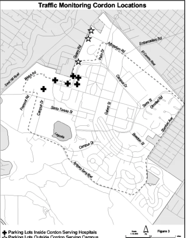
a. Peak hour traffic for a single year shall be determined through counts taken at three times during the year. All counts shall be conducted during the regular academic year, which does not include academic breaks or end-of-quarter finals. Specific times for each count shall be determined by the County Planning Office. The three annual counts shall be averaged to determine the annual traffic level for the baseline and each monitoring year. b. All counts shall be taken at the campus entry and exit points shown in Figure
3, which together form the defined cordon line.
c. Traffic counts shall include a license plate survey and matching to determine the rate of cut-through traffic.
d. Cordon volumes will be adjusted to account for use of parking lots within the cordon line by hospital-related traffic and use of lots outside the cordon line by campus-related traffic. These lots are identified in Figure 3 and in the Mitigation Monitoring and Reporting Program.
e. Based on the cordon counts, a peak hour will be identified for the campus. Peak hour traffic volume will be determined for the campus based on the cordon line count, adjusted for cut-through traffic and hospital parking as described above.
8. The County Planning Office will recognize participation by Stanford in
off-campus trip reduction efforts and credit reduced trips towards Stanford’s attainment of the no net new commute trips standard. Stanford shall receive credit
commensurate with the predicted or actual number of trips reduced, and the proportion of the cost of the program that Stanford is contributing. Trip reduction must occur in the area between US 101, Valparaiso Avenue/Sand Hill Road,
Interstate 280, and Arastradero Road/Charleston Road. The County Planning Office will determine the appropriate trip credit and monitoring methodology for each program in which Stanford proposes to participate. Such proposals shall be submitted to the Planning Office for review, modification, and consideration of approval. The proposals shall be presented to the CRG prior to any determination by the Planning Office.
9. The Planning Office shall monitor the cordon count volumes using the
procedures described above. If the cordon counts, as modified by trip reduction credits, exceed the baseline volume as calculated under Condition G.6 by 1% or more for any two out of three consecutive years, mitigation of impacts to intersections will be required as described in Table 4:
Table 4: Intersections Impact Mitigations
Intersection Jurisdiction Modification
El Camino Real/Valparaiso Menlo Park Change NB and SB right turn lanes to shared through/right lanes
El Camino Real/Ravenswood Menlo Park Change NB and SB right turn lanes to shared through/right lanes
El Camino Real/Middle Menlo Park Add SB right turn lane JSB/Alpine/Santa Cruz Menlo Park Add EB right turn lane Sand Hill/I-280 Menlo Park Add EB left turn lane Sand Hill/Santa Cruz Menlo Park Add WB right turn lane
Sand Hill/Oak Menlo Park Add one EB and one WB through lane Middlefield/Willow Menlo Park Add EB right turn lane
El Camino Real/Churchill Palo Alto Add WB right turn lane; change shared left/right turn to exclusive left turn lane El Camino Real/Stanford Palo Alto Add EB right turn lane
Middlefield/University Palo Alto Add NB right turn lane ECR/Palm/ University Palo Alto Add WB right turn lane Junipero Serra/Page Mill Palo Alto Add second SB right turn lane Junipero Serra/Stanford Santa Clara
County
Add second WB left turn lane; widen SB JSB between Stanford and Page Mill JSB/Campus Dr. West Santa Clara Co. Add second WB right turn lane
a. Stanford shall contribute funding proportional to the level of its impact from traffic associated with the GUP to the appropriate jurisdictions for
modification of the intersections as described above. At the time the
modifications are to be completed, alternative modifications or other efforts which have equal or greater impact mitigation value for the affected
intersections may be identified, based on consultation between Stanford and the appropriate jurisdiction with approval by the County Planning
Commission.
b. The appropriate proportional funding for the identified mitigations shall be determined by the County Planning Office, in consultation with the affected jurisdictions.
c. Stanford and the affected jurisdictions shall reach an agreement on
mitigations and funding within twelve months of the time that the County has determined that intersection-based mitigation will be necessary. Stanford shall do one of the following alternatives: 1) allocate the proportionate
funding for the project during this time, to be provided to the jurisdiction or placed in an independent escrow account, or 2) reach an agreement with the
affected jurisdictions for an alternate mitigation that achieves the same traffic result. If option 2 is proposed, the County Planning Commission must concur with the option and plan. If neither of these options is achieved, development at Stanford shall be suspended until an agreement is reached and funding is allocated or the no net new commute trips requirement is satisfied.
d. If the City of Menlo Park approves widening of Sand Hill Road and associated intersection modifications prior to the time that the intersection modifications described above are triggered, Stanford shall not be required to fund intersection modifications at Junipero Serra Boulevard/Campus Drive West, Junipero Serra/Alpine/Santa Cruz, Santa Cruz/Sand Hill, or Sand Hill/Oak intersections. If the City of Menlo Park does not approve widening of Sand Hill Road and associated intersection modifications prior to the time that the GUP-related intersection modifications are triggered, Stanford shall place its share of the funds for modification of these intersections into an independent escrow account until either the City of Menlo Park does approve the widening or the funding that Stanford has provided to the City of Menlo Park for that purpose expires. If the City of Menlo Park approves the
widening and associated intersection modifications during the time that the funds for these GUP-related intersection modifications are in escrow, the funds shall be returned to Stanford. If the City of Menlo Park allows the funds for the widening of Sand Hill Road to expire, the GUP-related escrow funds shall remain in escrow until they are used by the appropriate
jurisdiction.
e. Modifications to individual intersections either included or in addition to those in the above list may be required as the result of project-specific traffic studies, as described in Condition G.11.
10. Neighborhood traffic studies. Stanford shall participate in any future
neighborhood traffic studies initiated by the County of Santa Clara, City of Palo Alto or City of Menlo Park in the area bounded by Middlefield Road, Willow Road/Santa Cruz Avenue/Sand Hill Road, Interstate 280, and Page Mill Road/Oregon
Expressway. Stanford shall not be required to fund more than 50% of the cost of any such study. Stanford shall not be required to pay more than a total of $100,000 toward such neighborhood traffic studies over the GUP period, or more than $50,000 for any single neighborhood traffic study. The purpose of Stanford’s participation in such a study shall be to determine how much, if any, cut-through traffic in
residential neighborhoods is attributable to traffic generated by the central campus. If impacts attributable to central campus traffic are identified in the studies, Stanford shall contribute to reasonable identified mitigation measures to a degree
proportional to Stanford’s impact from development associated with the GUP. It is the responsibility of the jurisdiction sponsoring the study to inform the County Planning Office of any such study and formally request enforcement of this condition. Stanford’s participation in a study may be waived if:
a. The sponsoring jurisdiction has waived this requirement of Stanford for any individual study.
b. On request by Stanford, the County Planning Commission has waived this requirement of Stanford for any individual study, or adjusted the proportion of the cost of the study that Stanford will be required to pay. The Planning Commission’s action may be appealed to the County Board of Supervisors by any interested person.
11. Project-specific traffic studies. Stanford shall submit for review and approval by the Planing Office project-specific traffic studies for the projects identified below, as well as other projects of similar size and scale. These studies shall address trip distribution (to determine whether distribution would be substantially different from the distribution assumed in the CP/GUP EIR) project safety, effects of the project on nearby streets and intersections, pedestrian and bicycle facilities, parking, and transit. At the discretion of the County Planning Office, traffic studies may also be required for other proposed projects.
a. Addition of housing in Escondido Village, including but not limited to
housing along El Camino Real adjacent to Escondido Village, that exceeds 100 units
b. West Campus and Lagunita faculty/staff housing development c. Performing Arts Center
d. Expansion/replacement of basketball arena e. Stanford Avenue faculty/staff housing
f. Parking lots or structures with a net increase in spaces of 400 or more 12. Construction Traffic. Stanford shall comply with the following conditions regarding management of traffic related to construction activities and submit a plan implementing the following standards for approval by the County Planning Office prior to the commencement of any new building construction:
a. Stanford shall provide adequate off-street parking for all construction-related vehicles throughout the construction period. If adequate parking cannot be provided on the construction sites, a satellite parking area shall be
designated, and a shuttle bus shall be operated.
b. Stanford shall not substantially limit pedestrian circulation during construction of the project.
c. Stanford shall not substantially reduce bicycle circulation while constructing the project.
d. Stanford shall make feasible attempts to limit the number of construction material deliveries from 7:00 AM to 9:00 AM and from 4:00 PM to 6:00 PM on weekdays. Stanford shall be required to prohibit or limit the number of construction employees from arriving or departing the site between the hours of 4:30 PM and 6:00 PM.
e. Stanford shall be prohibited from limiting access to public transit, and from limiting movement of public transit vehicles as a result of the construction activities.
f. Stanford shall prevent roadway construction activities from reducing
roadway capacity during major athletic events or other special events, which attract a substantial number of visitors to the campus.
g. Stanford shall inform the Stanford Police and Palo Alto Fire Department of construction locations, and alternate evacuation and emergency routes shall be designated to maintain response times during construction periods. h. Stanford shall provide written notification to all contractors regarding
appropriate routes to and from construction sites and weight and speed limits for local roads used to access construction sites. A copy of all such written notifications shall be submitted to the County Planning Office. i. Stanford shall post at least one sign no smaller than 1,296 square inches at all
active construction sites. The sign shall contain the name and telephone number or e-mail address of the appropriate Stanford person the public may contact to report alleged violations of this Condition G.12 or to register complaints about construction traffic associated with building projects under this GUP. Stanford shall keep a written record of all such complaints and shall provided copies of these records to the County Planning Office as part of the annual report process.
13. Special Events. Within one year of GUP approval, Stanford shall submit a Special Events Traffic Management Plan to the County Planning Office. After the Plan is presented to the CRG, the Planning Office shall determine whether the Plan complies with this condition. The Plan shall include, but not be limited to, the following:
a. Identification of appropriate traffic control mechanisms, personnel and procedures to ensure the orderly flow of traffic during special events. b. Public notification by Stanford at least 5 days prior to events where
attendance is expected to meet or exceed 10,000 persons. Public notification shall include, but not be limited to, publication in two newspapers of general circulation in the Palo Alto and Menlo Park area (e.g., Palo Alto Weekly, Palo Alto Daily News). Information provided in the notice shall include but not be limited to the date, time and specific location of the event, identification of the public streets or other facilities that will be closed or otherwise
substantially affected by the event, and suggested alternate transportation routes. If more than one such event is anticipated during a given week, the public notifications for all of the week’s events may be combined. The notice shall be at least 1/8 of a page in size.
c. Establishment and maintenance by Stanford of a special events telephone hotline and website accessible to the general public where information on
upcoming special events and associated traffic impacts as described in subsection (a) may be obtained.
14. Junipero Serra Boulevard/Stanford Avenue. Stanford shall convene regular meetings of a multi-jurisdictional group to address the existing traffic problems of volume, safety, and noise on Junipero Serra Boulevard and Stanford Avenue. The group shall include representatives from the University and the Stanford Campus Residential Leaseholders (or its successor organization), and may include
representatives from the County’s Fifth Supervisorial District Office, County
Department of Roads and Airports, the City of Palo Alto, the Stanford Golf Club, the College Terrace Residents’ Association, and/or the California Highway Patrol. The objective of these meetings is to identify and work toward implementation of feasible solutions to the existing problems of Stanford Avenue and the Junipero Serra Boulevard corridor. These problems include but are not limited to noise, access from residential driveways, and the safety of motorists, pedestrians, and bicyclists. If traffic mitigations affecting Stanford Avenue or Junipero Serra Boulevard are triggered by failure to achieve the “no net new commute trips” standard, Stanford and Santa Clara County will, in consultation with the multi-jurisdictional group, reevaluate the mitigation measures identified in the EIR prepared for the Community Plan and GUP and determine if equally effective mitigation measures or alternatives are preferable. In doing so, the members of the multi-jurisdictional group may help form solutions, comment on their feasibility, and participate in their prioritizing. This process will also facilitate the ability of participants to comment to the agency or agencies with jurisdiction over
implementation of such mitigation measures. The annual report shall include information regarding the success or failure in addressing these concerns.
H. Parking
1. The total net additional parking spaces on the campus shall not exceed 2,300 spaces, with the exception of parking provided for any housing in excess of 3,018 units, which shall be considered by the County Planning Commission at the time of consideration of the housing proposal. Net additional parking in each development district shall not exceed the totals specified in Table 5, except with environmental assessment as specified in Condition D.6. Parking constructed as part of and to serve new faculty/staff housing in the areas designated Campus Residential-Low Density and Campus Residential-Medium Density shall not count toward the limits shown in Table 5.
Table 5: Parking Distribution – Maximum Net Additional Parking per Development District
Development District Net additional parking spaces
West Campus 50 Lathrop 50 Foothills 0 Lagunita 700 Campus Center 200 Quarry 800 Arboretum 0
DAPER & Administrative 1,700
East Campus 900
San Juan 100
2. In addition to the neighborhood traffic study funding requirements in Condition G.10, Stanford shall participate in residential parking permit programs in
neighborhoods within the City of Palo Alto that are immediately adjacent to the campus and have a demonstrated spillover parking impact from activities on Stanford lands in unincorporated Santa Clara County as specified below:
a. Within twelve months of General Use Permit approval, Stanford shall allocate funding to the City of Palo Alto or to an escrow account for a residential parking permit program in the College Terrace neighborhood, bounded by Stanford Avenue, El Camino Real, California Avenue, and Amherst Street. The funding shall be for the purpose of consideration and initiation of a parking permit program and shall not be required to exceed $100,000.
b. If the cost of the consideration and initiation of a residential parking permit program for College Terrace is less than $100,000, the remaining increment of the $100,000 may be used by the City of Palo Alto to conduct a study of parking activity for the Southgate and Evergreen Park neighborhoods in the area bounded by the Caltrain tracks, Churchill Avenue, El Camino Real, and Cambridge Avenue. The purpose of the study would be to determine if there is a need for a residential parking permit program to be initiated in these neighborhoods due to activity on Stanford lands in unincorporated Santa Clara County. The funds may be used for this purpose at any time during the term of this General Use Permit, and shall remain in escrow until they are used by the City of Palo Alto. If the funds are not used by the City of Palo Alto during the term of the General Use Permit they shall revert to Stanford.
I. Parks and Recreation Facilities
1. Stanford shall improve parks in the San Juan faculty/staff residential area to provide recreational opportunities for the population of that neighborhood to a level that would provide equal recreational value as any facilities in this area which would be removed as a result of construction under the GUP. A proposed
recreation facility improvement program, including but not limited to a timeline for improvements, shall be submitted to the County Planning Office for review by the ASA Committee within twelve months of GUP approval. No building permit may be issued to Stanford for development within this district without an approved program and timeline for improvements. Recreation facility improvements shall be adopted as conditions of project approval within the San Juan development district. 2. Stanford shall dedicate easements for, develop, and maintain the portions of the two trail alignments which cross Stanford lands shown in the 1995 Santa Clara Countywide Trails Master Plan (Routes S1 and C1), according to the following timeline:
a. In consultation with the County Parks and Recreation Department, Stanford shall identify trail easements and complete Agreements for Trail Easements within one year of GUP approval. For purposes of this condition, the term “easement” includes any other equally enforceable mechanism acceptable to the County Board of Supervisors.
b. Stanford shall work with the County Parks and Recreation Department to identify responsibilities for trail construction, management and maintenance. An agreement regarding these issues, including but not limited to a time frame for implementation, shall be reached within one year of GUP approval.
J. California Tiger Salamander
1. Habitat protection easements required for protection of the California tiger salamander (CTS) shall meet the following specifications:
a. Easements shall be dedicated to the County of Santa Clara. For purposes of this Condition, the term “easement” includes any other equally protective and enforceable mechanism acceptable to the County Board of Supervisors. b. Easements shall remain in effect until such time as protection of CTS is no
longer warranted, either through removal from consideration for listing or de-listing under the state or federal Endangered Species Act or other local, state, or federal laws, ordinances and regulations related to the protection of the species, or if the species becomes extinct.
c. The easements may also be abandoned by the County if all buildings
constructed under the General Use Permit in the CTS management zone are removed and the habitat is restored for CTS.
d. Stanford shall prepare a detailed management and monitoring plan, subject to approval of the County Planning Office in consultation with the United
States Fish and Wildlife Service (USFWS), to ensure the long-term maintenance and protection of CTS habitat values on lands covered by habitat protection easements. The plan shall be approved prior to or concurrent with approval of any individual easement dedication, and shall address requirements for fencing, vegetation control, enhancement of small mammal populations, maintenance of safe migration and dispersal corridors, and management of potential sources of mortality.
e. The first location for habitat protection easements shall consist of preserved, created or restored upland habitat within 500 meters of breeding habitat, including either Lake Lagunita or created ponds in which successful CTS reproduction has been documented for at least three consecutive years with near- or above-normal rainfall, excluding any intervening years with
substantially below normal rainfall. When all areas that meet this description have been placed in easement protection, easements may be granted on other open space lands that provide migration and dispersal corridors for CTS to the breeding habitat.
f. The total area for the easements shall be calculated based on the area of building footprints, roads, paved and unpaved parking areas, pathways, ornamental landscape plantings, and any other area where CTS habitat will be lost or modified, or where CTS access to habitat will be impeded.
2. Habitat protection easements shall more specifically be required as follows: a. Prior to any development activity in the CTS Management Zone as shown in
Figure 4, Stanford shall dedicate an easement over the entirety of Lake Lagunita to the top of the lake banks. The acreage of this easement shall count toward other existing habitat easement dedication requirements as defined in Condition J.2.b, below.
b. Prior to County approval of any proposed building project on occupied CTS habitat, Stanford shall dedicate an easement providing for protection and management of an amount of land equal to 3 times the acreage of the site to be disturbed. “Occupied CTS habitat” shall include open areas around Lake Lagunita, the Lower Knoll, and the Gerona Triangle, as shown on Figure 4; other areas within the CTS management zone shall be surveyed by an independent qualified biologist, hired by the County at the expense of Stanford, to determine if they contain occupied CTS habitat as defined through the survey. The survey shall be conducted in accordance with the survey protocol for CTS approved by the California Department of Fish and Game (CDFG) or the USFWS.
c. As an alternative to the easement at a 3:1 ratio of protected area to disturbed area described above, Stanford may restore, protect, and manage for CTS use areas within 500 meters of Lake Lagunita which do not currently serve as occupied CTS habitat. Areas which may be used for restoration include the driving range and any areas currently developed with buildings, parking areas, or roadways. The restoration area shall be equal in size to the area
disturbed by a proposed building project. Restored areas shall be placed in easements subject to all terms described in Condition J.1 above.
3. Prior to issuance of a building permit for a proposed building project on occupied CTS habitat within 500 meters of Lake Lagunita, Stanford shall create three new breeding ponds or enhance an equal number of existing ponds in the area south of Junipero Serra Boulevard. Pond success shall be documented in created ponds for three consecutive years of near- to above-normal rainfall, excluding any intervening years with substantially below normal rainfall, prior to building permit issuance. Design and management requirements and success criteria for the ponds shall be established in consultation with the United States Fish and Wildlife Service (USFWS) and approved by the County Planning Office.
4. All CTS monitoring shall be verified or conducted by an independent, qualified biologist selected and hired by the County of Santa Clara at the expense of Stanford University.
5. On a project-by-project basis, the following measures shall be required prior to any construction in the CTS management zone:
a. A preconstruction survey for CTS shall be conducted by an independent, qualified biologist at the beginning of the rainy season in accordance with CDFG standard procedures for preconstruction surveys. The survey shall be submitted to the County Planning Office. If CTS are found in any area that will be affected by the construction, Stanford shall consult with CDFG, USFWS, and the County Planning Office to determine if salvage of salamanders is warranted and, if so, what method should be used. The
construction area shall be calculated and identified on construction drawings, and the area of impacts shall be monitored by the contractor and by Stanford during construction, with regular reports to the County Planning Office. b. Construction vehicles shall be limited to a speed of 10 mph. Any fuels on
these sites shall be double contained and excess asphalt shall be removed from the site upon completion of construction.
c. Drift fences (e.g., silt fences or other effective salamander barriers) shall be erected around the project site prior to November 15 to prevent CTS from wandering into areas where they could experience mortality or injury. 6. The following operational measures shall be required at sites within the CTS Management Zone:
a. Utility boxes and other ground-level fixtures shall be maintained to prevent accidental trapping of salamanders. Outdoor lighting shall be minimized. Facilities on the sites shall be kept clean from exposed garbage. Domestic animals shall not be allowed as regular residents of the sites. The drip-line of oak trees present on site shall be kept clear of structures. Ground squirrel control shall not be allowed except as required in the Lake Lagunita dam and levee pursuant to the requirements of the State Division of Dam Safety.
Landscaping features shall be limited to native species, to the extent feasible, that do not require the use of pesticides and fertilizers.
b. Curbs, planters, and other landscape elements shall be designed to direct salamanders away from the building complex, access road, and parking area. Gravel-covered french drains shall be constructed instead of typical storm drains. Utility boxes with as few openings to the surface as possible shall be selected to prevent accidental trappings of salamanders.
7. Stanford and the County Planning Office shall continue to comply with all requirements and recommendations of the 1998 California Tiger Salamander Management Agreement.
8. Within 3 years of General Use Permit approval, Stanford shall construct between one and three passageways for salamanders providing for safe passage across Junipero Serra Boulevard. The number and design of these passageways shall be determined in consultation with the United States Fish and Wildlife Service and submitted to the County Planning Office for approval. If an alternate, equally or more effective measure is approved by the County Planning Office in consultation with the USFWS, such a measure may replace these passageways.
9. If the CTS is listed as threatened or endangered under the federal Endangered Species Act or any successor statute with the purpose of protecting endangered or threatened species, an appropriate permit will be obtained from the USFWS. The conditions of the GUP that address CTS shall be superseded by any subsequent Habitat Conservation Plan (HCP) approved by the USFWS, so long as the HCP provides at least as much habitat value and protection for CTS as these Conditions of Approval.
K. Biological Resources
1. For all proposed building projects located in a riparian, disturbed riparian, oak woodland, annual grassland-oak woodland, or modified oak woodland area as identified in the Community Plan/General Use Permit Environmental Impact Report, the County at the expense of Stanford will retain an independent qualified biologist to conduct focused surveys for special-status plants. Stanford shall notify the County of potential proposed building projects in adequate time to conduct the appropriate surveys at the appropriate time of the year. The purpose of these surveys will be to locate and identify any special-status plants that may occur in the proposed construction zone. If special-status plants are found, the following
measures shall be required:
a. The designated construction zone for new facilities shall be designed to provide, to the extent feasible, an exclusionary buffer with a minimum size of 30 feet from special-status plant resources.
b. A mesh fence shall be installed at the boundary of exclusionary buffer zones established for special-status plant resources prior to the initiation of ground-disturbing activities.
c. Where complete avoidance cannot be achieved, Stanford shall submit a site-specific mitigation and compensation program for the affected resources developed in consultation with the California Department of Fish and Game and/or the U.S. Fish and Wildlife Service.
d. Any special-status plants within the construction zone shall be transplanted on suitable Stanford lands in consultation with the California Department of Fish and Game and U.S. Fish and Wildlife Service. Any lost plant habitat shall be replaced at a ratio of two acres of replacement habitat for each acre of special-status plant habitat lost.
e. Stanford shall provide funding for the County to retain an independent qualified biologist to monitor or verify monitoring of the mitigation sites annually for five years using success criteria developed in coordination with the California Department of Fish and Game and U.S. Fish and Wildlife Service. The success of the transplantation program shall be considered to have been achieved if 80% or more of the transplanted plants have survived five years after transplantation. Monitoring results shall be part of the annual report.
2. For each proposed building project requiring an environmental assessment, Stanford shall provide funding for the County to retain a qualified biologist to conduct pre-construction surveys for breeding raptors and migratory birds which may be affected by the project. Specific need and timing of surveys will be
recommended through environmental review of individual proposed building projects and included in the conditions of approval for the projects. If active nest sites are located, appropriate construction setbacks from nest sites shall be required by the County in consultation with the California Department of Fish and Game (CDFG). No construction activities shall occur within the construction setback during the nesting season of the affected species. Sites identified shall be part of the annual report.
3. For any proposed building project located in an oak woodland area as identified in the Community Plan/General Use Permit Environmental Impact Report, Stanford shall create or restore oak woodland habitat at a ratio of at least 1.5:1 (1.5 acres of restored habitat: 1 acre of developed habitat). Restoration plans shall be prepared and implemented by Stanford for each proposed building project that would result in a loss of oak woodland habitat. Restoration design, compensation ratios, and monitoring requirements shall be proposed by Stanford in consultation with the CDFG and submitted to the County Planning Office for review and approval to ensure that comparable habitat values are attained in the replacement habitat. Monitoring activities shall be part of the annual report.
4. All proposed building projects shall be sited and designed to minimize loss of trees protected by the County of Santa Clara tree preservation ordinance. In the event that protected trees would be affected by a proposed building project, Stanford shall do one of the following:
a. Stanford shall implement the construction management practices and tree replacement requirements set forth in the County's tree preservation
ordinance. Trees shall be replaced at a ratio of 3:1 for oaks and 1:1 for other protected trees.
b. Stanford may submit a Vegetation Management Plan for the entire campus to the County Planning Office for review and approval. This plan must provide for the same or greater level of tree protection as the measures described in subsection (a) above.
c. All tree removal and replacement shall be described in the annual report. 5. Within six months of General Use Permit approval, Stanford shall retain a qualified biologist to generally define areas with potential jurisdictional wetlands and other waters of the U.S. Within one year of the GUP approval, this description shall be submitted to the County Planning Office for review and approval. For any proposed building project located in an area which may include wetlands as shown in this description, the following measures shall be required:
a. An independent qualified biologist shall conduct a delineation of potential jurisdictional wetlands and other waters of the U.S. present on the site. b. Development projects shall be sited and designed to avoid and/or minimize
impacts to jurisdictional wetlands or other waters of the U.S.
c. If jurisdictional wetlands or other waters of the U.S. will be unavoidably lost as a result of project activities, Stanford shall obtain appropriate
authorization from the U.S. Army Corps of Engineers under Section 404 of the Clean Water Act. In coordination with the U.S. Army Corps of Engineers, any wetlands or other waters of the U.S. that are lost as a result of future development in the project area shall be replaced through the creation, preservation, or restoration of wetlands or other waters of the U.S. of at least equal function and value to those that are lost.
6. Stanford shall provide the County Planning Office updates to California Natural Diversity Database records as they are available, including electronic updates compatible with the Planning Office’s electronic map format standards. Stanford shall report on the status of this database for inclusion in the annual report. 7. Within 12 months of approval of the General Use Permit, Stanford shall submit
to the County Planning Office for approval a Special Conservation Plan, in accordance with the requirements of the Community Plan.
L. Visual Resources
1. Prior to or in connection with submitting an application for any development along El Camino Real, Stanford shall submit a streetscape design for unincorporated Stanford lands along the south side of El Camino Real that includes but is not
limited to height and setback requirements that are, at a minimum, at least as stringent as those of the City of Palo Alto and may, at the request of the ASA Committee, be more stringent. The streetscape design shall be prepared in
consultation with the City of Palo Alto and shall be presented to the CRG before being submitted to the County Planning Office for review and approval.
2. For any development along Stanford Avenue, there shall be a minimum 25-foot building setback from Stanford Avenue and buildings shall be constructed at a height of 30 feet or less. Building height and setback shall be defined and measured consistent with the provisions of the Santa Clara County Zoning Ordinance. A landscape plan shall also be required for any development along Stanford Avenue. 3. Stanford shall submit a lighting plan for approval by the County Planning Office, as part of an ASA review, for each development project that would include exterior light sources. The plan shall show the extent of illumination that would be projected from proposed outdoor lighting. State of the art luminaries shall be used where necessary, with high beam efficiency, sharp cut-off, and glare and spill control. Upward glow shall not be allowed in residential or academic uses.
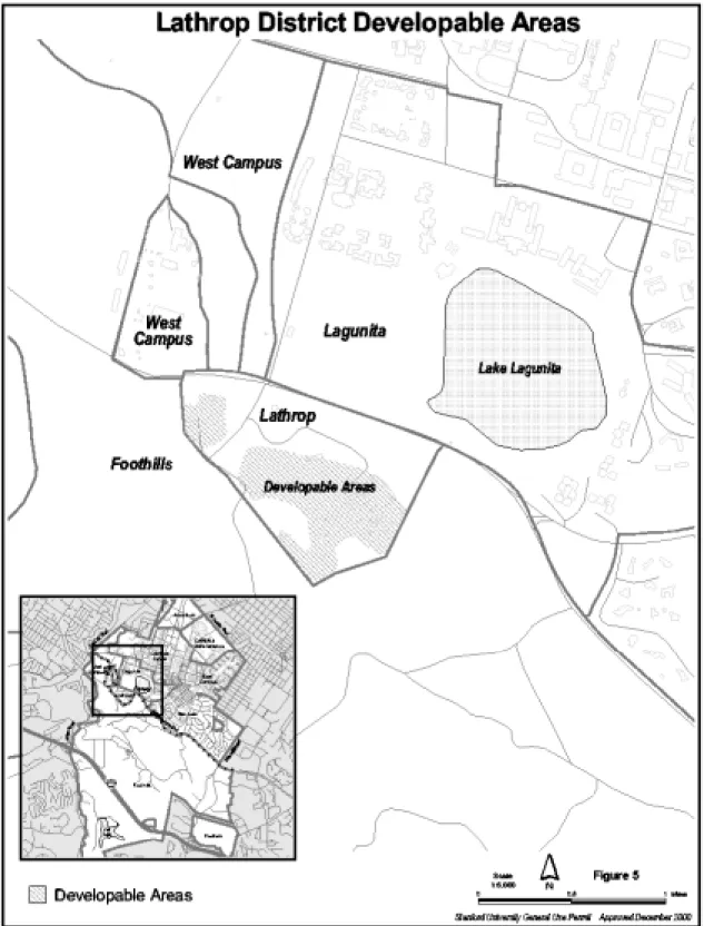
4. Development in the Lathrop development district shall occur only in the areas shown in Figure 5. Structures which are not for the purpose of occupancy, such as fences or golf course access bridges, may be permitted in other areas of the Lathrop district in accordance with the requirements of the Santa Clara County Zoning Ordinance.
M. Hazardous Materials
1. Stanford shall disclose the projected quantities and types of hazardous materials associated with each proposed building project and identify measures for storing materials and protecting users from potential risks as part of their application to the County Planning Office. If a proposed building project would involve quantities of hazardous materials that trigger the California Accidental Release Prevention Law requirements, Stanford shall prepare a Risk Management Plan and shall implement all measures identified in the accident prevention program. If feasible, the quantities of hazardous materials stored shall be reduced below the California Accidental Release Prevention Law thresholds.
2. Stanford shall maintain and enhance its programs for the storage, handling, and disposal of hazardous materials. Information on the status of such programs shall be provided to the County as a component of the annual monitoring process. Programs shall continue to include, as necessary:
a. Training of all persons involved in the use, handling, and disposal of hazardous materials;
b. Use of appropriate storage and control technology in all facilities in which hazardous materials are used;
c. Preparation of Hazardous Materials Management Plans for facilities where hazardous materials are stored, in compliance with the requirements of the County Department of Environmental Health;
d. Compliance with all relevant federal, state, and local regulations; e. Ongoing use of the University Committee on Health and Safety;
f. Maintenance and enhancement of ongoing risk assessment procedures by the University Department of Environmental Health and Safety; and
g. Maintenance and enhancement of activities of the University’s Hazardous Waste Program.
N. Geology and Hydrology
1. Stanford shall comply with all requirements of the Uniform Building Code, the County Geologist, the County Building Inspection Office, the Stock Farm Monocline Agreement, and any other agreements defined during the term of the General Use Permit with regard to reduction of seismic risk associated with new or remodeled facilities on the campus.
2. Stanford shall accommodate the potential for increased storm water runoff using one of the following two options, or a combination of options as appropriate.
Activities to implement this condition shall be part of the annual report.
a. Stanford shall prepare a site-specific hydrology and drainage study for each proposed building project and shall design, construct, and maintain project specific storm drainage system improvements sufficient to assure that the peak storm runoff leaving the developed site does not increase, and that any increased runoff does not cause downstream flooding. Individual detention facilities may serve more than one building project, but Stanford must demonstrate adequate detention capacity to contain increased runoff as part of the application for any proposed building project.
b. In place of site-specific studies, Stanford may elect to prepare a hydrology and drainage study for all or a specified portion of a particular watershed area, as shown in Figure 6. This plan shall be submitted to the County Planning office for review and approval. Based on the results of this study, Stanford shall design, construct, and maintain storm drainage improvements sufficient to assure that the peak storm runoff leaving Stanford lands covered by the study would not increase over existing peak levels and that the total runoff would not cause downstream flooding. Upon improvement of facilities in accordance with the plan, no further site specific hydrology and drainage studies will be required for a proposed building project on a site within the area covered by the study, provided that the proposed building project is consistent with the assumptions in the study.
3. All detention facilities or other storm water management facilities shall be designed to only store storm water runoff temporarily and not create extended ponding.