Uncontrolled when printed. Check to verify correct version before use.
Earth Venture 1
Data Management Plan
DISCOVER-AQ Science Directorate NASA Langley Research Center National Aeronautics and
Space Administration Document Number: Version: Effective Date: D-AQ-DMP-01 1 6/22/2011
Change Log
Table of Contents
1.0 INTRODUCTION... 5
2.0 DISCOVER-AQ PROJECT SCIENCE DATA FLOW ... 6
2.1 SCIENCE DATA GENERATION AND DOCUMENTATION REQUIREMENTS ... 7
2.2 SCIENCE DATA FORMAT AND METADATA REQUIREMENTS ... 8
2.2.1 DISCOVER-AQ Metadata Requirements: ... 8
2.2.2 DISCOVER-AQ Datafile Naming Convention: ... 9
2.3 SCIENCE DATA STORAGE AND DISTRIBUTION ... 9
2.4 POST-MISSION STEWARDSHIP AND ACCESS ... 11
3.0 DISCOVER-AQ DATA PRODUCTS ... 12
3.1 DISCOVER-AQAIRBORNE OBSERVATIONAL DATA PRODUCTS ... 12
3.2 DISCOVER-AQGROUND-BASED OBSERVATIONAL DATA PRODUCTS ... 15
1.0 Introduction
The DISCOVER-AQ (Deriving Information on Surface Conditions from Column and Ver
The DISCOVER-AQ Data Management Plan (DMP) has been developed by the Data Manager, Dr. Gao Chen of NASA Langley Research Center, in consultation with the principal investigator (PI), project manager (PM), co-investigators (Co-Is), NASA LaRC ASDC staff, and NASA ESDIS (Earth Science Data and Information System Project). This DMP incorporates procedures that have evolved over more than 20 years of airborne field studies under NASA’s Tropospheric Chemistry Program (TCP) and draws upon experience from collaborations with NOAA, NSF, university, and international partners. This document outlines a detailed plan for all aspects of DISCOVER-AQ data management throughout its five-year project lifecycle, which will involve up to 4 field deployments. Each deployment will last approximately one month and have ~100 allocated flight hours for each airborne platform.
tically Resolved Observations Relevant to Air Quality) project will focus squarely on NASA’s goals to study the Earth from space to increase fundamental understanding and to enable the
application of satellite data for societal benefit. The overarching objective of the mission is to improve the interpretation of satellite observations to diagnose near-surface conditions relating to air quality. DISCOVER-AQ is an investigation that involves a wide range of observational assets, including airborne and ground based in-situ and remote sensing observations. DISCOVER-AQ is also a broad collaborative study with participants from three NASA centers, four universities, and research partners from agencies at federal, state and local levels, e.g., EPA (Environment Protection Agency), NOAA (National Oceanographic and
Atmospheric Administration), MDE (Maryland Department of the Environment, TCEQ (Texas Commission on Environmental Quality), and CARB (California Air Resources Board). Therefore, successfully achieving the DISCOVER-AQ science objectives requires a comprehensive and cohesive data management plan to govern seamless data exchange within the science team and between the science team and partners. An equally important goal of this plan is to provide timely public access to the data archive and to promote broader scientific use of the DISCOVER-AQ data in addressing issues related to satellite observations and air quality. This will be accomplished by transferring DISCOVER-AQ data to the NASA Langley Research Center’s Atmospheric Science Data Center (LaRC ASDC).
Detailed descriptions of project objectives, science objectives, implementation plans, and instrument overviews can be found in the DISCOVER-AQ proposal document, which is available
2.0 DISCOVER-AQ Project Science Data Flow
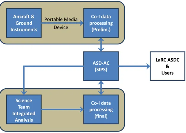
The schematic in Figure 1 illustrates the end-to-end data flow from initial acquisition of
airborne and ground-based measurements to archival at LaRC ASDC and distribution to users at large. Airborne Science Data for Atmospheric Composition (ASD-AC) will be assigned as the project-specific data repository for DISCOVER-AQ, which will play a key role in facilitating the project data exchange needs and interfacing with LaRC ASDC and users. The measurement Co-Is will be primarily responsible for operating research-grade instruments, processing data, and submitting data according to project schedules and format requirements. As shown in Figure 1, the DISCOVER-AQ project data processing will occur in two phases: 1) preliminary data
generated during the field deployment and 2) final data resulting from post-deployment processing and analysis. The final data will be transferred to LaRC ASDC. The DISCOVER-AQ PI, data management team, and most of the Co-Is have gained valuable experience from
participation in past NASA TCP airborne studies where a similar data flow scheme was successfully implemented.
Figure 1. DISCOVER-AQ Science Data Flow Schematic Diagram. The shaded boxes denote the DISCOVER-AQ project data management components. The term “SIPS” denotes Science Investigator-led Processing System.
The DISCOVER-AQ airborne and ground-based observational data will be recorded during each one-month field deployment period. Preliminary airborne data will be submitted to the project-specific data repository, ASD-AC, within 24 hours after each flight. The same time
Aircraft & Ground Instruments Co-I data processing (Prelim.) Science Team Integrated Analysis ASD-AC (SIPS) Co-l data processing (final) LaRC ASDC & Users Field Deployment Phase
Post-Deployment Phase Portable Media
latency requirement will apply to ground site preliminary data for each calendar day. The preliminary data will be generated using preliminary (or in-field) calibrations with minimal time allowed for QA/QC processing. The timely submission is required because the preliminary data are used by the PI, PM, and project scientist to monitor project progress and to formulate plans for follow-up flights. Exceptions may be granted when flights are scheduled for consecutive days or if there are instrument problems. In these cases, the DISCOVER-AQ PI and PM must be notified. In addition, measurement Co-Is may seek prior approval from both the DISCOVER-AQ PI and PM for an exception if it is determined that the data submission period is too stringent in consideration of labor intensive data processing procedures. The distribution and use of
preliminary data will be limited to the DISCOVER-AQ science team and collaborators.
Preliminary data are not suitable for research, nor appropriate for public release, having not been adequately calibrated and QA/QCed. By contrast, final data are expected to be
scientifically defendable and suitable for publication in peer-reviewed journals. Measurement Co-Is are responsible for assuring that data conforms to the data file format requirements, particularly the metadata requirements. Final data will be submitted to ASD-AC within 4 months after the end of each field deployment. During this 4 month period, the Co-Is will reprocess their data using final calibrations and conduct full QA/QC processes, which include science team integrated interpretive analysis and comparison with diagnostic models. DISCOVER-AQ final data will be made available to the public in compliance with NASA science data policy. The transfer process to LaRC ASDC will begin immediately after the completion of the final data submission.
2.1 Science Data Generation and Documentation Requirements
As described earlier, the measurement Co-Is are assigned the responsibility of data processing for their respective instruments. The data processing procedure will convert the primary instrument outputs to data products quantitatively describing atmospheric, chemical, and physical states, e.g., trace gas mixing ratio (or concentration) and aerosol/cloud droplet
microphysical, optical, and chemical properties. The data processing algorithms will be refined through detailed instrument characterization and calibration (if applicable) to ensure data quality in terms of accuracy and precision. This reflects the fact that all in-situ and remote-sensing instruments selected for the DISCOVER-AQ study have successfully been deployed in previous airborne studies. Most of these instruments and measurement techniques have been published in peer-reviewed scientific journals.
For in-situ instruments, the processing algorithms are mathematically straightforward. While remote-sensing data reduction uses algorithms similar in many ways to satellite retrievals, the data volumes involved are far smaller. As part of the DISCOVER-AQ proposal, each
measurement Co-I has budgeted sufficient financial, computational, and staffing resources necessary to process their instrument data and generate science data products.
To comply with the NASA data policy, the DISCOVER-AQ measurement Co-Is will be required to archive or reference sufficient documentation for each of the funded measurements at LaRC ASDC. The primary goals of the documentation requirement are: 1) to maintain data
reprocessing capability, 2) to maintain transparency of the data processing, and 3) to facilitate users’ understanding and use of data. This documentation should consist of an instrument description as well as primary instrument output data and ancillary data sets which are needed
for reprocessing. The instrument description document should include the measurement principle, instrument description, calibration procedures and standards (if applicable), data processing procedure (including software if necessary), data validation (if applicable), data revision records, and uncertainties/detection limits. Since much of the information can often be found in peer-reviewed publications, relevant publications can be used as references. The document itself should primarily be focused on the details or modifications specific to the instrument operation for each of the DISCOVER-AQ field deployments. The program scientist, PI, project scientist, and PM, in consultation with the Co-I and an assigned representative from LaRC ASDC, will determine the appropriate documentation requirements for each instrument on a case-by-case basis. As defined in Section 2.3, documentation materials will be submitted to LaRC ASDC along with the final data within 9 months of the end of each deployment.
2.2 Science Data Format and Metadata Requirements
The DISCOVER-AQ observational data products will conform to NASA Earth Science Division approved data system standards. The in-situ data is required to be archived in the International Consortium for Atmospheric Research on Transport and Transformation (ICARTT) data format, i.e., ESDS-RFC-019. A detailed description of the data format protocol can be found at
sensing data products will be archived in the Hierarchical Data Format (HDF 5) data format, which is described a As required by the ICARTT format protocol, all DISCOVER-AQ observational data will be reported with universal time (UT) for the time record. The measurement Co-Is are required to synchronize their instruments to GPS time. In addition to the format standards, the DISCOVER-AQ project has a specific file naming convention and set of metadata content requirements. These additional requirements are intended to promote the usability of the DISCOVER-AQ data.
2.2.1 DISCOVER-AQ Metadata Requirements:
The DISCOVER-AQ metadata requirements are developed to meet the Distributed Active Archive Center (DAAC) collection level and granule level metadata requirements. It is also noted that these requirements largely overlap with the ICARTT data file format protocol but are an additional requirement for Co-Is who opt to archive their data in HDF-5 format. A metadata file equivalent to the ICARTT file header is required to accompany each HDF-5 data file. This will ensure the consistency in metadata collection for all measurements.
Platform and associated location data: Geographic location and altitude will be embedded as part of the data file or provided via a link to the archival location of the aircraft navigational data.
Data Source Contact Information: phone number, mailing information, and e-mail address shall be given for the measurement Co-I and one alternate contact
Data Information: Clear definition of measured quantities will be given in plain English, avoiding the use of undefined acronyms, along with reporting units and limitation of data use if
applicable.
.
Measurement Description: A simple description of the measurement technique with reference to readme file and relevant journal publication.
Measurement Uncertainty: Overall uncertainty will need to be given as a minimum. Ideally, precision and accuracy will be provided explicitly. The confidence level associated with the reported uncertainties will also need to be specified for the reported uncertainties if it is applicable. The measurement uncertainty can be reported as constants for entire flights or as separate variables. It is noted that measurement uncertainty is required by the ICARTT data file format.
Data Quality Flags: definition of flag codes for missing data (not reported due to instrument malfunction or calibration) and detection limits.
Data Revision Comments: Provide sufficient discussion about rationale for data revision. The discussions should focus on highlighting issues, solutions, assumptions, and impact.
2.2.2 DISCOVER-AQ Datafile Naming Convention:
The DISCOVER-AQ file naming convention is derived from the ICARTT file naming convention. The DISCOVER-AQ file names are limited to 127 characters or less and are defined as follows: dataID_locationID_YYYYMMDD_R#
The only allowed characters are: a-z A-Z 0-9_.- (that is, upper case and lower case alphanumeric, underscore, period, and hyphen). Fields are described as follows:
dataID: an identifier of measured parameter/species, instrument, or model (e.g., O3; NxOy; and PTRMS). For DISCOVER-AQ data files, the Co-Is are required to use “DISCOVER-AQ_” as prefixes for their DataIDs, i.e., AQ_O3, AQ_NxOy, and DISCOVER-AQ_PTRMS.
locationID: an identifier of airborne platform or ground station, e.g., P3B. Specific locationIDs for each deployment will be provided on the DISCOVER-AQ data website.
YYYY: four-digit year MM: two-digit month
DD: two-digit day (for flight data, the date corresponds to the UT date at take off)
R#: data revision number. For preliminary data, revision number will start from letter “A”, e.g., RA, RB, … etc. Numerical values will be used for the final data, e.g., R1, R2, R3 … etc.
extension: “ict” will be the file extension for ICARTT files, “h5” will denote HDF 5 files.
For example, the filename for the P-3B Diode Laser Spectrometer H2O measurement made on July, 1, 2011 flight may be: DISCOVERAQ_DLH-H2O_P3B_20110701_R1.ict
The date in the file name gives the date at which the data within the data file began. For aircraft and sonde data files, the date always refers to the UT date of take-off or launch. Multiple flights or launches within the same calendar day can be accommodated by addition of a volume number in the file name. For ground sites, data files should correspond to a calendar day based on local time, although the timestamp in the file should still utilize UT to report time.
2.3 Science Data Storage and Distribution
During the project life cycle, DISCOVER-AQ science data products (a detailed list defined in Section 3) will be archived at the ASD-AC. A science team data archive for DISCOVER-AQ will be set up at http://www-air.larc.nasa.gov/missions/discover-aq/discover-aq.html to host
airborne and ground-based preliminary and final data. Also archived are scientifically relevant ground-based remote sensing and in-situ observation data sets from collaborators and data merge products, i.e., aggregated observational data from a common platform or ground site provided on a common time base.
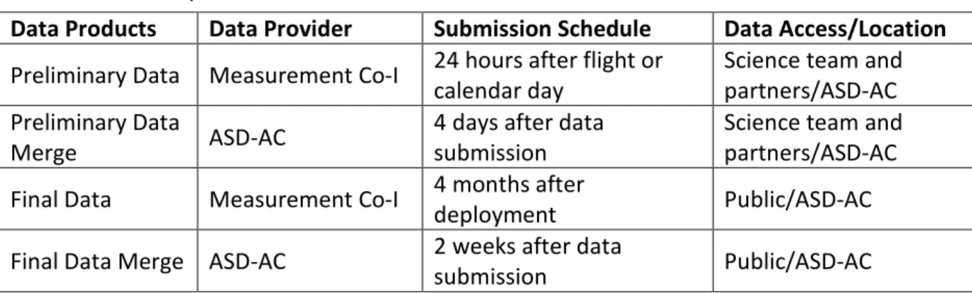
The merge data products will be generated by ASD-AC for both preliminary data and final data to assist the project analysis effort. The merge files associate the atmospheric measurements with the sampling location and meteorological environment and thus offer a means to readily analyze the covariance of the common platform atmospheric measurements. Nominally, 1 -second and 10--second merge files will be created for the NASA P-3B science flights and 600-second merge files will be produced for the ground site observations. Special merges requested by Co-Is or partners will be accommodated. The preliminary merge files will be generated during the deployment phase and will be updated as data are being revised. Table 1 summarizes the submission schedule and access control along the DISCOVER-AQ science data flow illustrated in Figure 1. Also given is the data archive location. The DISCOVER-AQ final data along with documentation materials will be transferred to LaRC ASDC within 9 months of the completion of each deployment.
Table 1. Summary of DISCOVER-AQ Data Submission Schedule and Flow
Data Products Data Provider Submission Schedule Data Access/Location
Preliminary Data Measurement Co-I 24 hours after flight or calendar day Science team and partners/ASD-AC Preliminary Data
Merge ASD-AC 4 days after data submission Science team and partners/ASD-AC Final Data Measurement Co-I 4 months after deployment Public/ASD-AC Final Data Merge ASD-AC 2 weeks after data submission Public/ASD-AC The measurement Co-Is are required to submit their data file in standard format defined in section 3. A downloadable version of the scanning software will be made available at the data archive for use by the Co-Is to help them prepare their data files. ASD-AC will also scan
incoming ICARTT files upon delivery to ensure that the data format requirements are met. Password-based access control will be established by ASD-AC to limit data sharing to appropriate DISCOVER-AQ participants for data processing purposes during the first four months after each field deployment. This time period allows Co-Is to process final data. In addition to the archive function, ASD-AC will be responsible for transferring data to LaRC ASDC. The DISCOVER-AQ project requires close collaboration with state and local environmental departments, e.g., MDE, TCEQ, CARB, and EPA. The ASD-AC will be responsible for establishing data sharing agreements with partner organizations and provide web links/access to members of the DISCOVER-AQ science team.
2.4 Post-Mission Stewardship and Access
The LaRC ASDC will provide post-mission access to DISCOVER-AQ data products. The DISCOVER-AQ science team is committed to the timely release of “publication quality” data products for public use in scientific research activities. The transfer of final science data and associated documentation to LaRC ASDC will be a joint effort between ASD-AC and LaRC ASDC. Specifics of the data and transfer mechanisms will be defined in an Interface Control Document (ICD), which will be developed collaboratively by LaRC ASDC and ASD-AC within 1 month after the final data submission. The primary goal is to perform accurate and timely ingest of the DISCOVER-AQ science data products into the LaRC ASDC data archive and distribution system.
Before each deployment, the ASD-AC will initiate contact with LaRC ASDC to discuss the data transfer plan, which includes the data format, file types, and metadata requirements. By working with the measurement Co-Is, the ASD-AC will take the responsibility to provide the LaRC ASDC with a reasonable estimate of the total size of the archive, including both science data products and associated documentation.
Prior to delivery, the ASD-AC will work closely with the LaRC ASDC to create collection, granule, and browse metadata files. DISCOVER-AQ metadata will be exported to EOS Clearing House (ECHO) and archive and distribution metrics will be provided to the ESDIS Metrics System (EMS). After delivery of data and documentation for each deployment, the ASD-AC will work LaRC ASDC to generate and submit a DIF (Directory Interchange Format) entry to GCMD (Global Change Master Directory) for DISCOVER-AQ science data products. These activities are to ensure the DISCOVER-AQ science data and appropriate ancillary records are properly ingested into LaRC ASDC data archive and distribution system to support long-term usability.
3.0 DISCOVER-AQ Data Products
This section defines a list of measurement data products that will be archived to fulfill the DISCOVER-AQ observational data product requirements. Items specifically provided here are definitions of the measured quantities, spatial and/or temporal resolutions of the reported data, instruments/techniques, and measurement Co-Is. The measured quantities are named to be consistent with GCMD convention. The temporal resolution is given to indicate the interval at which the data will be reported. The total file volume for DISCOVER-AQ science data products and associated documentation is estimated to be less than 1 TB per deployment. As stated in Section 2.0, preliminary data submission is required within 24 hours after each flight or after each calendar day for ground-based measurements. The final data are due 4 months after the end of each deployment. As described in Section 2.0, some measurements are
exempt from the 24 hour preliminary data submission requirement (marked by “*” in the tables below).
3.1 DISCOVER-AQ Airborne Observational Data Products
Table 2A summarizes the atmospheric trace gases measurements onboard NASA P-3B. All data will be delivered in the ICARTT format. The data volume for science data files and associated documentation is estimated to be <180 GB for each field deployment.
Table 2A. P-3B in situ Trace Gas Measurement Data Products
Co-I Species Technique or Instrument Time Resolution
Cohen
Nitrogen Dioxide (NO2)
Thermal-Dissociation, Laser-Induced Fluorescence
1 s
Total Peroxy Nitrates <10 s
Total Alkyl Nitrates <10 s
Nitric Acid (HNO3) <10 s
Weinheimer
Ozone (O3)
Chemiluminescence
1 s
Nitric Oxide (NO) 1 s
Nitrogen Dioxide (NO2) 1 s
Total Reactive Nitrogen (NOy) 1 s Fried Formaldehyde (CH2O) IR Absorption Spectrometer 1 s Vay Carbon Dioxide (CO2) Modified LI-COR 6252 1 s Diskin
Carbon Monoxide (CO) Diode Laser Spectrometer 1 s
Methane (CH4) 1 s
Water Vapor (H2O) Diode Laser Hygrometer 1 s
Wisthaler
Methanol (CH3OH)*
Proton Transfer Reaction-Mass Spectrometer
10 s
Acetaldehyde (CH3CHO) * 10 s
Acetone ((CH3)2CO) * 10 s
Isoprene*, Methyl Vinyl Ketone
(MVK)/Methacrolein( MACR) * 10 s
Acetonitrile (CH3CN) * 10 s
Benzene (C6H6) *, Toluene
Table 2B summarizes the atmospheric aerosol property measurement data sets from NASA P-3B aircraft platform. All data will be delivered in ICARTT format. The “size range” column provides the particle size range of measurement which is limited by either instrument or the sampling inlet (i.e., < 10 µm). The data volume for science data files and associated
documentation is estimated to be < 520 GB for each field deployment.
Table 2B. P-3B in situ Aerosol Measurement Data Products (Co-I: Bruce Anderson)
Parameter Technique/Instrument Time Resolution Size Rangea
(µm) Total Particle Number Density Condensation Particle Counters (TSI 3025) 1 s 0.003 – 1 Particle Number Density Condensation Particle
Counters (TSI 3010) 1 s 0.010 – 1 Nonvolatile Particle Number Density 1 s 0.010 – 1
Aerosol Particle Size Distribution
TSI Scanning Mobility
Particle Sizer 120 s 0.01 – 0.3 DMT Ultra-High Sensitivity
Aerosol Spectrometer 5 s 0.08 – 1.0 Aerodynamic Particle Sizer
(TSI 3321) 5 s 0.5 – 10 Scattering Coefficient Nephelometer (TSI 3563) 1 s <10 Absorption Coefficient Particle Soot Absorption Photometer 5 – 120 sb <10 Black Carbon Density DMT Single Particle Soot Photometer 5 s 0.01 – 1.0 Particle Chloride Concentration*
Particle into Liquid Sampler/Ion
Chromatograph 300 s 0.01 – 1.0 Particle Nitrate Concentration*
Particle Sulfate Concentration* Particle Ammonium Concentration* Particle Sodium Concentration* Particle Potassium Concentration* Water Soluble Organic Carbon (WSOC) concentration
Particle into Liquid Sampler/Total Organic
Carbon 30 s 0.01 – 1.0
a the 10 µm upper limit of the size range is limited by the sampling inlet and sampling line transmission efficiency.
Table 2C summarizes the NASA P-3B aircraft navigational and meteorological data sets. All data will be delivered in ICARTT format. The data volume for science data files and associated documentation is estimated to be < 5 GB for each field deployment.
Table 2C. P-3B Navigational and Meteorological Measurement Data Products (Co-I: Barrick)
Parameter Technique/Instrument Time Resolution
GPS Latitude and Longitude GPS/Trimble TNL-3000 1 s
GPS Altitude 1 s
Pressure MEMS/Rosemount MADT 2014 1 s
Pressure Altitude Calculated/Rosemount MADT 2014 1 s Radar Altitude Radar Altimeter/ Honeywell AA-300 1 s Pitch, Roll, and Heading
INS/Honeywell Laseref
1 s
Wind Speed and Direction 1 s
Ground Speed 1 s
Ground Track 1 s
True Air Speed 1 s
Ambient Temperature PRT/Rosemount E102 Non-Deiced 1 s Dew Point Edgetech Vigilant 137 3-stage chilled mirror hygrometer 1 s NO2 photolysis frequency Metcon jNO2 filter radiometers 1 s
Table 3 outlines the observational data products from the NASA King Air platform, which consist of aerosol optical properties and NO2 column measurements, as well as King Air navigational data. All remote-sensing data will be delivered in the HDF-5 format. A separate metadata file is required for each HDF-5 data file that is submitted. The navigational data will be delivered in the ICARTT format. The volume of the total science data files and associated documentation is estimated to be less than 150 GB.
Table 3. King Air (UC-12/B200) Remote Sensing Measurement Data Products
Co-I Parameter Instrument Time/Spatial Resolution
Hostetler
Aerosol Backscatter (532 & 1064 nm) High Spectral Resolution Lidar 10 s ~1 km hor. 60 m vert. Aerosol Extinction (532 nm) 60 s ~6 km hor. 300 m vert. Depolarization (532 & 1064 nm) 10 s ~1 km hor. 60 m vert. Aerosol Optical Depth (532 nm) 60 s ~6 km hor.
GPS Time, Latitude, Longitude, and
Altitude Applanix 510 0.5 s Janz Slant Column Nitrogen Dioxide (NO2) Airborne Compact
Atmospheric Mapper
1 km x 1 km, ~1 sec. Slant Column Ozone (O3) 1 km x 7 km, < 10 sec. Slant Column Nitrogen Dioxide (NO2) 1 km x 7 km, < 10 sec. Slant Column Formaldehyde (CH2O) 1 km x 7 km, < 10 sec.
3.2 DISCOVER-AQ Ground-Based Observational Data Products
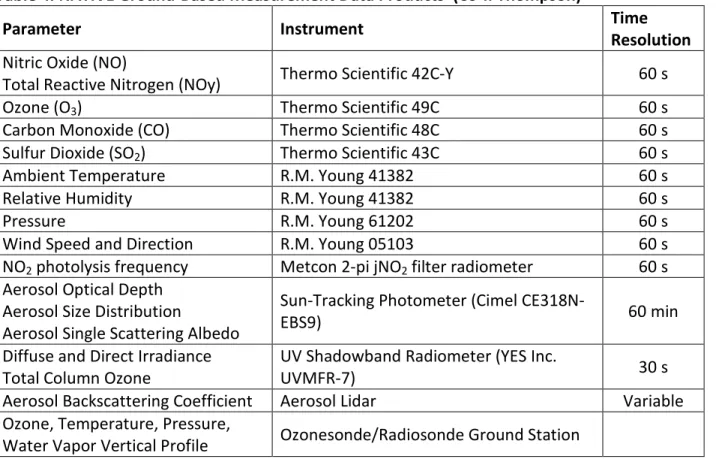
Table 4 defines data products collected from the NATIVE trailer, which includes in-situ, remote sensing, and ozone sonde measurements. All data will be delivered in the ICARTT format. The volume for data products and associated documentation is estimated to be less than 5 GB Table 4. NATIVE Ground-Based Measurement Data Products (Co-I: Thompson)
Parameter Instrument Time Resolution
Nitric Oxide (NO)
Total Reactive Nitrogen (NOy) Thermo Scientific 42C-Y 60 s
Ozone (O3) Thermo Scientific 49C 60 s
Carbon Monoxide (CO) Thermo Scientific 48C 60 s Sulfur Dioxide (SO2) Thermo Scientific 43C 60 s Ambient Temperature R.M. Young 41382 60 s
Relative Humidity R.M. Young 41382 60 s
Pressure R.M. Young 61202 60 s
Wind Speed and Direction R.M. Young 05103 60 s NO2 photolysis frequency Metcon 2-pi jNO2 filter radiometer 60 s Aerosol Optical Depth
Aerosol Size Distribution
Aerosol Single Scattering Albedo
Sun-Tracking Photometer (Cimel
CE318N-EBS9) 60 min
Diffuse and Direct Irradiance
Total Column Ozone UV Shadowband Radiometer (YES Inc. UVMFR-7) 30 s Aerosol Backscattering Coefficient Aerosol Lidar Variable Ozone, Temperature, Pressure,
Water Vapor Vertical Profile Ozonesonde/Radiosonde Ground Station
Table 5 summarizes the data products from Pandora measurements. All data will be delivered in the ICARTT format. The volume for data products and associated documentation is estimated to be less than 40 GB (< 0.1 GB/instrument/day) for the deployment period.
Table 5. Pandora Measurement Products (Co-I Herman)
Parameter Instrument Time Resolution Spatial Resolution
Total Columns of: Ozone (O3), Nitrogen Dioxide (NO2), Formaldehyde (CH2O), Sulfur Dioxide (SO2), Water Vapor (H2O), and Bromine Oxide (BrO) Aerosol optical Depth
Pandora-Direct Sun 10 mina Total Column Aerosol size and refractive index Pandora Sky
Scan 10 min
Ozone Vertical Profile* 3-5 km
NO2 Vertical Profile* 1 km
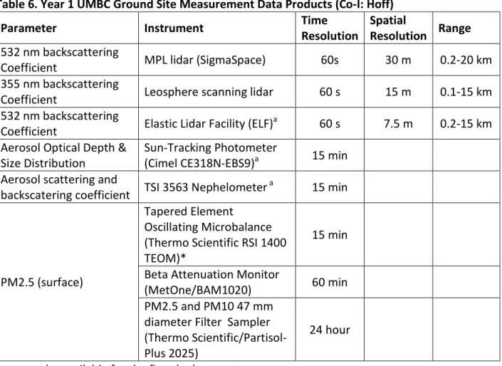
Table 6 defines ground-based LIDAR data products. The data will be recorded in the HDF-5 format. A separate metadata file is required for each HDF-5 data file that is submitted. The PM2.5 data will be submitted in ICARTT format. The volume of the total science data files and associated documentation is estimated to be less than 50 GB.
Table 6. Year 1 UMBC Ground Site Measurement Data Products (Co-I: Hoff)
Parameter Instrument Time Resolution Spatial Resolution Range
532 nm backscattering
Coefficient MPL lidar (SigmaSpace) 60s 30 m 0.2-20 km 355 nm backscattering
Coefficient Leosphere scanning lidar 60 s 15 m 0.1-15 km 532 nm backscattering
Coefficient Elastic Lidar Facility (ELF)a 60 s 7.5 m 0.2-15 km Aerosol Optical Depth &
Size Distribution Sun-Tracking Photometer (Cimel CE318N-EBS9)a 15 min Aerosol scattering and
backscatering coefficient TSI 3563 Nephelometer a 15 min
PM2.5 (surface)
Tapered Element
Oscillating Microbalance (Thermo Scientific RSI 1400 TEOM)*
15 min Beta Attenuation Monitor
(MetOne/BAM1020) 60 min PM2.5 and PM10 47 mm
diameter Filter Sampler (Thermo Scientific/Partisol-Plus 2025)
24 hour amay not be available for the first deployment.
4.0 Acronyms
ASD-AC Airborne Science Data for Atmospheric Composition ASDC Atmospheric Science Data Center
CARB California Air Resources Board
Co-I Co-Investigator
DIF Directory Interchange Format
DISCOVER-AQ Deriving Information on Surface Conditions from Column and Ver
DMP Data Management Plan
tically Resolved Observations Relevant to Air Quality
ECHO EOS Clearing HOuse
EMS ESDIS Metrics System
EPA Environmental Protection Agency
ESDIS Earth Science Data and Information System Project GCMD Global Change Master Directory
HDF Hierarchical Data Format
ICARTT International Consortium for Atmospheric Research on Transport and Transformation
LaRC NASA Langley Research Center
NOAA National Oceanographic and Atmospheric Administration
PI Principal Investigator
PM Project Manager
QA/QC Quality Assurance/Quality Control
SIPS Science Investigator-led Processing System TCEQ Texas Commission on Environmental Quality TCP Tropospheric Chemistry Program