NCSU Libraries and North Carolina Center
for Geographic Information & Analysis
North Carolina Geospatial Data Archiving
Project
In cooperation with the Library of Congress National
Digital Information Infrastructure and Preservation
Program
Interim Report
June 1, 2008
Principal Investigator: Steven P. Morris, NCSU Libraries
Co-Principal Investigator: Zsolt Nagy, NCCGIA
. . .
. . .
. . .
TABLE OF CONTENTS
Executive Summary... 1
Project Overview ... 5
Introduction... 5
Engaging Spatial Data Infrastructure (SDI)... 6
Original Work Plan... 6
Project Response to a Changing Environment... 7
Project Phases... 8
Content Identification and Selection... 9
Targeted Content ... 9
Digital Geospatial Data Types ... 10
Risks to Geospatial Data... 12
Source Organizations... 15
Data Inventories in Content Identification and Selection... 17
Present-Day NC GIS Inventory... 19
Frequency of Capture ... 20
Content Acquisition... 24
Data Acquisition Summary... 24
Data Formats ... 26
Developing Data Archiving Formats... 29
Geospatial Metadata ... 31
Data Acquisition and Transfer Technical Methods... 36
Legal and Intellectual Property Issues... 38
. . .
. . .
. . .
Emergent Content Acquisition Methods... 42
Partnership Building ... 45
Project Approach to Partnership Building ... 45
Advisory Committee... 48
Interagency Collaboration on Data Acquisition... 48
Emerging Content Exchange Networks... 50
Outreach and Engagement ... 52
Outreach and Engagement to Private Industry... 55
Collaboration with State Archives... 57
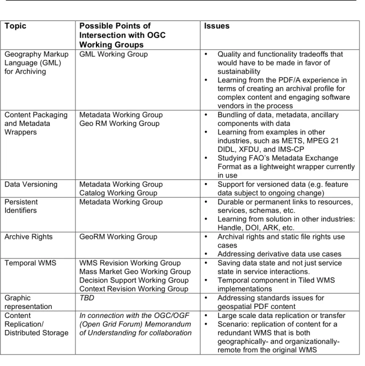
Engaging Standards Organizations... 59
Participation in NDIIPP Network Development... 61
Content Retention and Transfer... 62
Digital Repository Software Environment... 62
Repository Ingest Workflow Challenges... 63
Current NCGDAP Ingest Workflow ... 65
Repository Ingest Process ... 66
Data Access ... 68
Transfer of Data to Library of Congress... 71
Moving Forward... 72
Appendix A: Frequency of Geospatial Data Capture Survey... 74
Appendix B: Data Acquisition Summary... 96
Appendix C: NC Geologic Survey Maps ... 100
Appendix D: Geospatial Metadata Investigation Summary... 101
Appendix E: Rights Coding Scheme... 102
. . .
. . .
. . .
Appendix G: NCGDAP Outreach and Engagement Events ... 116
Appendix H: Points of Engagement with Standards Efforts ... 121
Appendix I: Storage and Backup System... 122
Appendix J: Repository Ingest Workflow... 123
Appendix K: Transfer Set Seed Files ... 130
Appendix L: Project Extension Work Plan ... 132
Executive Summary
Background
In October 2004 the NCSU Libraries and the NC Center for Geographic Information & Analysis entered into an agreement with the Library of Congress to pursue preservation of state and local digital geospatial data as part of the National Digital Information
Infrastructure and Preservation Program (NDIIPP). The goal of the North Carolina
Geospatial Data Archiving Project (NCGDAP) has been toinform development of a national digital preservation infrastructure through a “learning by doing” approach focused on
identifying, acquiring, and preserving content within the context of the NC OneMap initiative and its framework of partnerships with state, local, and federal agencies. Although this three-year project is focused solely on the state of North Carolina, it is expected to serve as a demonstration project for data archiving and time series development elsewhere.
Digital geospatial data includes such data resources as geographic information systems (GIS) data sets, digitized maps, remote sensing data resources, and tabular data that are tied to specific locations. These complex data objects do not suffer well from neglect, and long-term preservation will involve some combination of format migration and retention of critical documentation. At the state and local government level geospatial data resources are created by a wide range of agencies for use in applications such as tax assessment, transportation planning, hazard analysis, health planning, political redistricting, and utilities management. These data resources are, in general, of greater detail and more current than data available from federal agencies, yet production points for these resources are diffuse— 99 of 100 North Carolina counties have GIS, as do many cities—posing many challenges to the archive development process. Many of the targeted data resources are updated on a frequent basis—daily or weekly in some cases—yet data dissemination practices, for the most part, focus on providing access to current data.
Although often created with specific applications and functions in mind, these data resources are used in applications ranging far beyond those initially intended. End-user historical applications that might make use of historical and time series data include analyses of urbanization, environmental change, demographic change, land use change, and past uses of individual sites.
Project Overview
The original project work plan was based on a three-year performance period from October 2004 through September 2007, and the project has since been extended through March 2009. NCGDAP was conceived as demonstration preservation experience in which the archive being developed is seen not so much as an end in itself as it is a catalyst for
discussion among the various elements of spatial data infrastructure. That discussion, which includes libraries and archives, is centered not just on preservation processes and best practices but also on roles and responsibilities of the various players within the geospatial community.
NCGDAP focused less on technical architecture than it is on partnership building and on engagement with spatial data infrastructure. The purpose of the demonstration repository
developed for NCGDAP is to: 1) to catalyze discussion within the geospatial data community about archive development, and 2) to generate learning experiences about domain-specific technical challenges associated with preserving geospatial data. To this end, a demonstration repository using Dspace was deployed, and over 4 terabytes of data have been acquired to date. A robust repository ingest workflow was developed to handle the transformation of complex multi-file, multi-formats formats into discrete digital repository items.
Outreach and Engagement
While data preservation has been a low priority in the geospatial industry, emerging industry interest in temporal data use created numerous, mostly unexpected opportunities to engage the data community. Key outreach and engagement outcomes included:
• Elements of spatial data infrastructure within the state, including the NC Geographic
Coordinating Council (GICC) and its various subcommittees, were directly engaged in project work.
• A survey of current local government data archives practices documented the current
situation and helped to socialize the problem of data preservation within the data community.
• Through partnerships with EDINA (UK) and the National Archives and Records
Administration, NCGDAP played a direct role in the formation of a Data Preservation Working Group within the geospatial standards organization: the Open Geospatial Consortium (OGC).
• The project led to the initiation of the NDIIPP-funded Multi-State Geospatial Content
Transfer and Archival Demonstration and Project (started in November 2007).
• State Archives was informally engaged in the project work and will be formally engaged
in the project extension and Multi-State work.
• A new Archival and Long-Term Access Committee was formed under the NC GICC, with
representation from federal, state, regional, and local government agencies.
An Evolving Content Domain
The geospatial data domain involves a complex mix of both data and services. In terms of understanding the evolving geospatial content domain, a number of learning experiences have emerged in the course of the project, including:
• PDF has emerged as a significant geospatial format. The ability of PDF to capture and
preserve elements of cartographic representation makes it a powerful tool for capturing finished output in a way that the underlying datasets cannot, though underlying data intelligence is lost. Complex PDF documents, including those in the proprietary GeoPDF format, present new preservation challenges of their own.
• There is significant local agency interest in resurrecting old analog maps for use in the
digital environment. This interest creates a point of engagement and dialog around the issue of preserving current geospatial data for use in future historical analyses.
• The true counterpart to the old, preserved map is not the current GIS dataset but rather
the cartographic representation that builds on that data. The representation is the result of a collection of intellectual choices and application of current methods with regard to symbolization, classification, data modeling, and annotation. These representations typically occur in a complex proprietary project file format (difficult to preserve) or in an
ephemeral web services interaction. Increasingly PDF is providing an option for static representations.
• Important data community documents such as inventories, standards, and policy or best
practices documents must themselves be archived; in more than one case inventory information that had been retired from agency websites was retrieved from the Internet Archive.
Engaging Spatial Data Infrastructure
At the outset it was understood that an infrastructure-based approach was needed to address preservation of geospatial data given the size and complexity of data resources and given the diffusion of production points at the state and local level. In terms of understanding the role that spatial data infrastructure might play in preservation, a number of learning experiences have emerged in the course of the project, including:
• Formal, structured data exchange networks, even if developed for other business
reasons, support data archiving efforts by providing a low cost and routinized means to acquire data which is authenticated, documented, and for which rights have been clarified.
• The path to digital preservation may lead through other more compelling business
problems. There is a significant overlap between the conjoined problems of business continuity and disaster preparedness and the lower priority problem of digital
preservation.
• Regional efforts serve as building blocks for statewide infrastructure and provide diverse
testbed environments for network development.
• State Archives and State Libraries have the potential to serve as significant components
of state data infrastructures. Local records outreach and retention schedule processes serve as existing infrastructure which might be leveraged into geospatial data
management.
Engaging Industry
There is a degree to which one might consider the geospatial industry to be to some extent “temporally-impaired.” In terms of understanding how to engage the geospatial community, both data producers and users, in the preservation challenge, a number of learning experiences have emerged in the course of the project, including:
• Promotion of temporal analysis opportunities and requirements indirectly promotes data
preservation by cultivating demand for older data.
• Data is more likely to survive if users are made aware of the data’s existence and the
data is being actively sought and used.
• Software and data vendors are increasingly coming to see maintenance and use of
temporal data as an important customer problem.
• The best outreach and engagement efforts may be those that are indirect in nature. For
example, the process of working with the data community on reviewing and refining a survey on current data retention practices served to socialize the problem of digital preservation more than any other outreach mechanism employed in the course of the project.
Technical Challenges: A Deeper Understanding
It was understood at the outset that geospatial data involves complex multi-file, multi-format content and is increasingly prone to be delivered by web services or to exist in spatial databases. In terms of addressing the technical challenges associated with geospatial data, a number of learning experiences have emerged in the course of the project, including:
• To the extent that geospatial metadata is available, it commonly needs to be
synchronized to match the dataset at hand, normalized to a standard structure, and remediated to support discoverability via key fields.
• Mapping descriptive, technical, and administrative metadata elements to a single
repository ingest spoke helped to refine the thinking about what discrete elements should be maintained within the project. The collective experiences of specific repository
software communities, as represented in default metadata schemas, can help to shape metadata approach. It is possible that mapping to multiple repository ingest
environments would help to evolve a more robust metadata approach within the project.
Moving Forward
The new GICC committee and the Multi-State geospatial project have been initiated under the leadership of the stakeholder community, and it is expected that these efforts will be closely aligned with the most immediate business needs of those stakeholders, with the “who, what, where, why, and how” of data archiving being addressed in very practical terms. With the more immediate and more conventional problems being addressed in the new GICC committee and the Multi-State geospatial project, there will be an opportunity for NCGDAP to focus on and take leadership in investigations and efforts that are not so directly tied to immediate business needs but which do contribute to the solution of the longer-term challenges of data preservation.
The project work has been organized by the four project phases: 1) Content Identification and Selection, 2) Content Acquisition, 3) Partnership Building, and 4) Content Retention and Transfer. This report details project findings and accomplishments during the initial three year work period according to those phases.
Project Overview
IntroductionIn October 2004 the NCSU Libraries and the NC Center for Geographic Information & Analysis entered into an agreement with the Library of Congress to pursue preservation of state and local digital geospatial data as part of the National Digital Information
Infrastructure and Preservation Program (NDIIPP).1 The goal of the North Carolina
Geospatial Data Archiving Project (NCGDAP) is toinform development of a national digital preservation infrastructure through a “learning by doing” approach focused on identifying, acquiring, and preserving content within the context of the NC OneMap initiative and its framework of partnerships with state, local, and federal agencies.2 As a component of the
National Map3, NC OneMap provides an opportunity to engage content through traditional
distribution channels such as data download as well as through emerging web services based modes of access. Although this project is focused solely on the state of North Carolina, it is expected to serve as a demonstration project for data archiving and time series development elsewhere.
“Digital geospatial data” consists of digital information that identifies the geographic location and characteristics of natural or constructed features and boundaries on the earth. Such data resources include geographic information systems (GIS) data sets, digitized maps, remote sensing data resources such as digital aerial photography, and tabular data that are tied to specific locations. These complex data objects do not suffer well from neglect, and long-term preservation will involve some combination of format migration and retention of critical documentation. At the state and local government level geospatial data resources are created by a wide range of agencies for use in applications such as tax assessment, transportation planning, hazard analysis, health planning, political redistricting, and utilities management. These data resources are, in general, of greater detail and more current than data available from federal agencies, yet production points for these resources are diffuse— 99 of 100 North Carolina counties have GIS, as do many cities—posing many challenges to the archive development process.4 Many of the targeted data resources are updated on a
frequent basis—daily or weekly in some cases—yet data dissemination practices, for the most part, focus on providing access to current data.
Although often created with specific applications and functions in mind, these data resources are used in applications ranging far beyond those initially intended. End-user historical applications that might make use of historical and time series data include
analyses of urbanization processes, environmental change, demographic change, land use change, and past uses of individual sites.
1 National Digital Information Infrastructure and Preservation Program (NDIIPP): http://www.digitalpreservation.gov/ 2 The NC Geospatial Data Archiving Project (NCGDAP): http://www.lib.ncsu.edu/ncgdap/; and NC OneMap: http://www.nconemap.net
3 National Map: http://nationalmap.gov/
4 An ongoing inventory of state and local agency geospatial data is available through the NC GIS Inventory:
http://www.nconemap.net/GISInventory/tabid/288/Default.aspx; A directory of county and city GIS data resources and services is available at http://www.lib.ncsu.edu/gis/counties.html
Engaging Spatial Data Infrastructure (SDI)
NCGDAP builds on earlier efforts by NCSU Libraries, beginning in the year 2000, to acquire and preserve state and local geospatial data. That effort began in response to two factors: 1) rising user demand for newly emerging local data, and 2) a growing sense of long-term risk to this newly emerging content. The challenge of scalability in terms of engaging and archiving content from well over 100 local agencies cultivated an understanding of the need for an infrastructure-based approach to archive development. It became clear that a preservation effort could only scale by building from existing geospatial data infrastructures that are evolving under the auspices of the National Spatial Data Infrastructure (NSDI), National Geospatial Programs Office (NGPO), Federal Geographic Data Committee, and Geospatial One-Stop (GOS).5 Spatial data infrastructure—which incorporates local, state, and federal government agencies as well as the private sector—had already been focused on such issues as data standards, best practices, data sharing agreements, metadata production and harvesting, catalog development, and services integration. However, archiving and preservation had not yet become an area of focus in these efforts.
The primary manifestation of spatial data infrastructure in North Carolina is NC OneMap, a combined state, federal, and local initiative that is focused on allowing users to view
geographic data seamlessly across North Carolina, search for and download data for use on their own GIS, view and query metadata, and determine agency data holdings through an on-line data inventory.6 Included in the NC OneMap vision statement is the assertion that
“Historic and temporal data will be maintained and available7.” While primarily focused on
access and content standardization, NC OneMap has offered a means by which to engage a large number of local agencies in the process of creating a digital preservation
infrastructure.
Original Work Plan
The original project work plan was based on a three-year performance period from October 2004 through September 2007. The project has since been extended through March 2009 [See Appendix L: Project Extension Work Plan]. Key original objectives of the project included:
• Identification of available resources through existing statewide data inventory processes • Acquisition of at-risk geospatial data, including static data such as digital orthophotos as
well time series data such as local land records and assessment data
• Development of a digital repository architecture for geospatial data, using open source
software tools such as DSpace
• Enhancement of existing geospatial metadata with additional preservation metadata,
using Metadata Encoding and Transmission Standard (METS) records as wrappers
• Investigation of automated identification and capture of data resources using emerging
Open Geospatial Consortium specifications for client interaction with data on remote servers
• Development of a model for data archiving and time series development
5 National Spatial Data Infrastructure (NSDI): http://www.fgdc.gov/nsdi/nsdi.html; National Geospatial Programs office (NGPO): http://www.usgs.gov/ngpo/; Federal geographic Data Committee (FGDC): http://www.fgdc.gov/, Geospatial One-Stop (GOS): http://www.geodata.gov/
6 About NC OneMap: http://www.nconemap.com/Default.aspx?tabid=289#initiative
NCGDAP was conceived as demonstration preservation experience in which the archive being developed is not so much an end in itself as it is a catalyst for discussion among the various elements of spatial data infrastructure. That discussion, which includes libraries and archives, is centered not just on preservation processes and best practices but also on roles and responsibilities of the various players in what the geospatial community.
Project Response to a Changing Environment
The original project proposal was completed in November 2003, and the project work plan was finalized in December 2004. In the ensuing years it was necessary to make a number of modifications to the project work plan and to some extent modify project focus.
Circumstances which triggered changes in approach included:
• Organizational and political considerations within the data producer community (e.g.,
a need to re-think method and scope of data acquisition in light of other state and federal efforts)
• Changes in content domain (e.g., new content forms and new distribution methods) • Emergent partnership opportunities (e.g., exploring niche or peripheral problem
areas with key partners as opportunities presented themselves)
• A deepened understanding of the technical challenges associated with preserving
geospatial data (e.g., a fuller understanding of the complexities of repository ingest workflow with geospatial data)
Key project shifts in focus from the original work plan include:
• More national, international, and private industry outreach and engagement than
expected
• Less focus on the use of METS for content packaging than planned • More focus on complex repository ingest workflow issues than expected • Unexpected involvement with formal standards processes
• More selectiveness in data acquisition than initially planned
• Unexpected collaboration on development of data exchange infrastructure • More focus on county data and less focus on state data than initially planned
In terms of populating the archive there was a reduction in efforts to acquire data in “high friction” situations, and an increase in efforts to increase the instances of “low friction” data acquisition through cultivation of common infrastructure in cooperation with statewide partners.
Project Phases
The project work has been organized by the four project phases which were conceived by Library of Congress as an organizational framework for developing digital preservation infrastructure. These phases include:
1. Content Identification and Selection 2. Content Acquisition
3. Partnership Building
4. Content Retention and Transfer
The following report details project findings and accomplishments during the initial three year work period according to those phases.
Content Identification and Selection
Targeted ContentThis project focuses on state and local geospatial data for a number of reasons. This data was seen to be particularly at risk, given the diffusion of production and custodianship points, and given the ephemeral nature of much of the data. State and local data was seen as particularly valuable, since it is typically more detailed, current, and accurate than federal sources, and since it includes thematic content not available through other sources.
Furthermore, this data is not directly addressed by archiving efforts at the federal level. A focus on the geospatial domain provides an opportunity to engage and learn from existing, relatively well-developed spatial data infrastructures, which center on states and aggregate upward to the federal level.
The following generalized checklist characterizes the process for determining which data resources fall within the domain of this project:
• Is the data geospatial in nature? (GIS data, remote sensing imagery, digital
maps, georeferenced, tabular data, georeferenced ancillary data)
• Is it a product produced by or for North Carolina? (state/local content,
university/NGO content, commercial content, regional federal products)
• If the data is in a digital map form, does it lend itself well to georegistration (not
exceptionally distorted)? (Digital map resources with extensive coverage and for which no alternate georegistered information sources already exist would be prioritized)
• If the data is tabular in form, is it of sub-county resolution? (e.g., land records)
General principles that were expected to apply as a default framework for acquisition efforts included:
• “Time-sensitive” data—those used to create time series or at short-term risk of
disappearing—would be acquired first. Targeted resources would include vector data that are routinely updated.
• Digital orthophotos, while “at risk,” are not “time-sensitive;” acquisition would be
largely deferred to years two and three of the project. Since orthophotos comprise the bulk of total collection file size, this would allow time for the redundant storage model to be fully implemented and tested.
• County and state data would be targeted from the first year of the project, since
there is greater knowledge about data availability for these agencies and more comprehensive benefit from initiation of time series development. Municipal, lead regional organization, not-for-profit, and university data would be targeted in later phases.
• Geographic gaps in existing agency acquisition efforts would be targeted for
early acquisition, with a particular focus on Western North Carolina, which had not been thoroughly addressed in earlier acquisition efforts.
Digital Geospatial Data Types
D
igital geospatial data takes a wide variety of forms, including vector data, imagery, and tabular data as well as other information types. Following is a brief description of the most common types.Vector Data
Vector data resources model features on the earth’s surface as points, lines, or polygons. For example, a well location or a school may be modeled as a point; a stream or street centerline may be modeled as a line; and a land parcel or school district may be modeled as a polygon. A vector data set may form a “data layer,” such as a streets dataset covering a county. State agency vector data is typically of larger scale (more detailed) than federal or national-level data. Even more detailed vector data is available at the county and municipal government level. If available as snapshots in time, vector data will be able to provide future researchers with historical information about human and environmental processes.
Unfortunately state and local agencies typically make only the current data versions available.
County and municipal data resources are in many ways analogous to the Sanborn Fire Insurance Maps published at the turn of the last century. Those maps, while created with a very narrow purpose in mind, survived by virtue of their relatively stable analog form and the intervention of interested organizations, including the Library of Congress. The new local geospatial data, while initially created for very specific administrative and operational purposes, already find uses in a wide range of applications beyond the intended uses.
Digital Orthophotography
A conventional aerial photograph contains image displacements caused by camera lens distortion, camera tip and tilt, terrain relief, and scale. The effects of camera tilt and terrain relief may be removed through a rectification process to create a digital orthophoto, which is a uniform scale photographic image—essentially a photographic map. Digital orthophotos are usually produced in TIFF, GeoTIFF, or BIL image format, with MrSID, JPEG, or JPEG 2000 compressed version created for image delivery. These images are georeferenced and can be used within GIS systems.
The mix of orthophoto resources available from federal, state, and local government agencies is beginning to make possible the analysis of change over time. The increasing frequency of local government orthophoto flights are further enabling such analyses, though the agencies in question typically focus on providing access to the most current images. County government orthophoto data is generally of much higher resolution than the state/federal data, with data resolution ranging from six inches ground surface per pixel in urban areas to two feet per pixel in some rural areas. Statewide orthophotos at a lower resolution (one meter) were created through a combined state and federal effort for the years 1993 (black and white) and 1998 (color infrared). More recently statewide efforts have been supplanted by a combination of individual county flights and regional
collaborative flights. Orthophoto flights are increasingly carried out under federal cost sharing programs. In North Carolina 99 counties currently have digital orthophotos and counties typically conduct orthophoto flights roughly every two to five years. File sizes for
an individual county flight can total in the hundreds of gigabytes, and 79 counties have had multiple flights.8 Overall frequency of orthophoto flights is increasing as is the quantity of data generated in each subsequent flight.
Digital Maps
A wide variety of digital maps are also being acquired. These maps represent intellectual content and meaning beyond that found in the underlying datasets, as the maps result from the combination of a number of components including: data layer selection and ordering, symbolization, classification, output of data models, and annotation. Some of these digital maps are georeferenced or produced in a multi-page atlas format. The rapid increase in production of PDF maps at the county level since project start was a major surprise and introduced unexpected project challenges and opportunities in the area of PDF selection and curation.
Key Finding: PDF has emerged as a significant geospatial format. The ability of PDF to capture and preserve elements of cartographic representation makes it a powerful tool for capturing finished output in a way that the underlying datasets cannot. At the same time, complex PDF documents, including those in the proprietary GeoPDF format, present new preservation challenges of their own.
There has been a surge of interest on the part of local agencies in the issue of making their older, analog content available in digital form either for their own project development or for public consumption.9 Local agencies are increasingly building time into their applications, and the general public is keenly interested in seeing this historic information. To the extent that this content already exists in digital form the content will be targeted for acquisition by NCGDAP. More to the point, the local interest in historic content provides an opportunity to connect with those agencies on the issue of preserving current digitally-born content.
Key Finding: There is significant local agency interest in resurrecting old analog maps for use in the digital environment. This interest creates a point of engagement and dialog around the issue of preserving current geospatial data for use in future historical analyses. Historical map imagery also helps to create an emotional connection to the issue of data preservation.
Tabular Data
Tabular data are numeric or textual data stored in database, spreadsheet, comma
separated value, or other like formats. A given geographic feature may be assigned many different attribute values based on tabular data that might be associated with that feature. Some tabular data may be associated with geographic features such as land parcels or census tracts. This project focuses solely on non-federal tabular data occurring at a granularity greater than county level. This largely concerns tax assessment data, which associates land parcel records with such attributes as property value, purchase price, purchase date, building type, construction date, square footage, zoning, land use, and
8 Inventory of County Orthophoto Flights in NC: http://www.nconemap.com/Portals/7/documents/ortho_dates.pdf 9 Local agency interest in digitizing older analog content was documented in the NCGDAP Frequency of Capture Survey: http://www.nconemap.com/Portals/7/documents/NCOneMap_NDIIPLocalGovSurvey_1106.pdf
owner name. These data are produced by county tax assessment agencies and are made publicly available according to public records law, often bundled together with land parcel vector data.
Risks to Geospatial Data
While key feature data layers such as land records, street centerlines, jurisdictional boundaries, and zoning are constantly changing, current data management practice commonly involves overwriting of older versions of data which are then no longer available for historical or trends analysis. Emerging web services- or API-based technologies pose further challenges to the archive development process as it becomes easier to get and use data without creating a local copy—secondary archives often being in part a by-product of providing data access.
Even if the data has been saved, there is a chain of possible failure events that can impede permanent access to data:
• To the extent that such data is saved, it may be stored in such a way that it is not
discoverable.
• If the data is discoverable, policies may not have addressed the issue of what sort of
access should be provided to older versions of data.
• If the data is accessible, there is a possibility that the storage media will no longer be
readable.
• If the media is readable, the data files themselves may be corrupt.
• If the files are not corrupt, it is possible that the files will be in a format that is no
longer supported by current software.
• If the format is useable, it is possible that the documentation needed to use and
understand the contents of the data will not exist.
Unlike vector data, digital orthophotography is not typically at risk of overwrite, yet data from older flights are known to have become less discoverable and less accessible.
While digital geospatial data inherits preservation challenges that apply to digital resources in general, this content area also presents a number of domain-specific challenges to the preservation process.
Unique Data Formats
Geospatial vector data file formats are highly complex and extremely sensitive to both format migration and software display environment, and backwards compatibility between versions of the same software can be problematic. The absence of widely adopted, open vector formats ensures that a preponderance of vector data exists in proprietary formats. Due to the complexity of the content, migration between formats can lead to unacceptable data distortion and data loss.
Data resources are often available from the data producers in multiple formats. Content may be available in “early stage” (e.g., pre-rectification orthoimagery), “middle stage” (e.g., rectified and quality-controlled orthoimagery), and “late stage” (e.g., compressed
suitable for long-term preservation. Information may be both added and lost during the early-to-late progression. For example, sometimes only the delivery version of a parcel data set includes attached assessment data. Conversely, delivery versions of images may be in lossy compressed formats in which information is lost. Data in late stages is usually easier to acquire than data in early stages.
Spatial Database Complexity
The emergence of spatial databases has further complicated the preservation of digital geospatial data. Spatial databases may consist of multiple individual datasets or “data layers,” while also storing components such as behaviors, relationships, classification schemes, data models, or annotations that are external to or in addition to the datasets themselves. The whole of the spatial database is greater than the sum of the parts, as database components that build on the individual data layers add value. These complex databases can be difficult to manage over time due to the complexity of data models, uncertainty over long-term support of proprietary database models, and reliance on specific database back ends for data storage. Local agencies are increasingly turning to spatial databases to manage geospatial data.
Fragility of Cartographic Representation
The true counterpart to the old, preserved map is not the current GIS dataset but rather the cartographic representation that builds on that data. The representation is the result of a collection of intellectual choices and application of current methods with regard to symbolization, classification, data modeling, and annotation. Unfortunately this
representation is typically stored either: a) in proprietary project file for which there is no preservation-safe alternative; b) in a complex PDF document in which the underlying data linkages have been severed; or c) as part of a web services-driven interface for which the displayed results are ephemeral. Exporting or converting these complex documents to preservable image formats captures the data view but loses the underlying data intelligence. There are semantic concerns as well, as the symbologies employed have particular
meanings within particular contexts at particular points in time. While the original proposal focused more exclusively on the data itself, growing awareness of the long-term value of these representations led to a focus on this issue that was not envisioned in the original work plan. Clearly, however, any preservation of cartographic representation should occur in addition to—not instead of--preserving the underlying data.
Key Finding: The true counterpart to the old, preserved map is not the current GIS dataset but rather the cartographic representation that builds on that data. The representation is the result of a collection of intellectual choices and application of current methods with regard to symbolization, classification, data modeling, and annotation. These representations typically occur in a complex proprietary project file format (difficult to preserve) or in an ephemeral web services interaction. Increasingly PDF is providing an option for static representations.
Semantic Issues
Heterogeneous approaches to dataset naming, attribute naming, and attribute classification schemes create both short- and long-term barriers to understanding and use of content.
Data producers are discovering that naming and coding inconsistencies complicate the process of data sharing even in the context of present day use. While good metadata can make it possible to interpret these components, such metadata is unfortunately often absent or may not include the data dictionaries associated with names and codes found in the data. “Framework data” content standards provide some hope for improved consistency in the content and structure of geospatial data.10
Time-Versioned Content
At the local level many vector data resources are continuously or at least periodically updated. County cadastral (land parcel) datasets, for example, are typically updated on a daily or weekly basis. Such time-versioned content, if preserved, can form the basis of time series analyses such as land use change analysis. Time-versioned content presents three distinct challenges to the archiving process:
• The updated data in many cases is simply over-written or otherwise modified with no
digital knowledge of the historic version maintained.
• Even if a data provider captures historic information, the absence of a standard
identifier scheme, such as associated with serial publications, makes it difficult to relate data versions outside of a local data collection context.
• An optimal capture frequency is difficult to determine for any particular type of data
given the significant variation in update frequencies among data producers.11
Metadata Unavailability or Inconsistency
In the Unites Stated, the geospatial metadata standard since 1994 has been the Federal Geographic Data Committee (FGDC) Content Standard for Digital Geospatial Metadata, commonly referred to as FGDC metadata.12 Geospatial metadata presents several distinct
challenges:
• In terms of government data, while FGDC metadata is mandated at the federal
level, it is less common at the state level, and only rarely available at the local level.13
• In cases where metadata is absent, an archive may able to populate some FGDC
record sections, yet only the data producers have the information needed to populate sections such as data quality and lineage.
• Even if metadata exists, the metadata information is often asynchronous with the
data (e.g., the metadata may not have been updated to reflect format or datum change) or the metadata may simply be incorrect.
10 Framework data comprises seven themes of geospatial data (geodetic control, orthoimagery, elevation, transportation, hydrography, governmental units, and cadastral information) used by most GIS applications. These data include an encoding of the geographic extent of the features and a minimal number of attributes needed to identify and describe the features. From: FGDC Framework: http://www.fgdc.gov/framework. Framework data standards and practices are also addresses at the state level, such as in the case of the NC GICC Standards: http://www.ncgicc.com/Default.aspx?tabid=141
11 NCGDAP Frequency of Capture Survey Results:
http://www.nconemap.com/Portals/7/documents/NCOneMap_NDIIPLocalGovSurvey_1106.pdf (See Appendix A) 12 FGDC Content Standard for Geospatial Metadata: http://www.fgdc.gov/metadata/geospatial-metadata-standards 13 According to the 2003 NC Local Government GIS Data Inventory only 26% of local agencies were creating FGDC-compliant metadata: http://www.nconemap.com/Portals/7/documents/local-inventory-pack.zip. In the NCGDAP Frequency of Capture Survey 25% of responding local agencies indicate that they were archiving FGDC-compliant metadata with their data.
• Since the original FGDC standard was a content standard for which no standard
encoding was defined; existing metadata commonly requires some degree of structural normalization in order for the metadata to be interoperable with a repository.
• The FGDC standard, while extensive, does not provide container spaces for the
added technical and administrative metadata elements needed for archival processes. Examples of metadata not supported by the standard include: data of data acquisition by the archive, rights of the archive vis-à-vis the data, plans for future transfers, technical information about method of transfer, and method of assuring integrity of the data.
Content Packaging
Geospatial data is characterized by complex, multi-file formats. In addition, datasets are often accompanied by metadata and ancillary documentation or data files which need to be bundled with the core dataset files. Furthermore, archival technical or administrative metadata elements not accommodated by FGDC records, such as non-producer rights information, must be bundled up with the data in some other way. Unfortunately, the geospatial industry has not adopted a standard content packaging scheme.
Ancillary files include metadata records, data dictionaries, additional data documentation, legend files, data licenses, disclaimers, and associated images. In many cases an individual ancillary file will be shared by many or all datasets in a given collection, creating the
requirement that the ancillary files either be replicated for bundling with individual datasets or referenced separately through a persistent access mechanism.
Other Archiving Challenges
Other preservation challenges include:
• Securing and adequately defining archival and use rights for content • Providing long-term support of coordinate systems and datums
• Maintaining the independence of the preserved content from any particular
repository software environment
Source Organizations
The scope of NCGDAP includes state and local geospatial data in North Carolina. Data produced at the state level is typically more detailed and current than data produced at the federal level but not so detailed and current as data produced at the county and municipal level. Data producing roles at the state versus the local level do vary somewhat state to state within the U.S., with some states following a decentralized data production pattern, as found in North Carolina, and other states having data production more strongly centralized at the state level. The scope of data production at the different levels of government in North Carolina are outlined here.
State Agencies
In addition to NCCGIA, over 20 state agencies in North Carolina have active GIS programs that are involved with geospatial data production and use.14 Key agencies include the Department of Transportation (NCDOT), the Department of Environment and Natural Resources (NCDENR), the North Carolina Flood Mapping Program, the Department of Agriculture, and the Department of Health and Human Services. Both NCDOT and NCDENR include several sub-departments with their own GIS programs. Many of the geospatial data resources created by these state agencies are included in the NC OneMap viewer and data download systems managed by NCCGIA15, yet many more data resources are not available in a central state repository. Data from these agencies are produced directly by state agencies, or are produced by private contractors, with the data coming into the ownership of the state agency under public records law. Some resources are developed in collaboration with or under a cost sharing agreement with federal agencies (e.g.,
orthophotography and surface hydrography).16 County Agencies
Geospatial data development has typically been initiated by the county tax assessment (or land records) office and focuses on development of resources such as high-resolution digital orthophotos, street centerlines with addresses, and municipal boundaries, all of which are needed for tax assessment operations. Digital orthophotos provide the base material for creation of vector layers such as land parcels and so are typically the first data resource created. This data is usually much more detailed and more current than data available from the state or federal level. Much of the data is initially produced by private contractors for the county, which then takes ownership of the data under public records law and continues data maintenance. Base data, including orthophotography, is often taken by other county
departments in order to create additional data layers for the county. As county GIS programs mature, the data comes to be employed by a wide range of agencies outside of tax operations, and more data layers representing features such as school locations, utility lines, elevation, and land use zones are created. To meet broader demand for GIS
services, operations are often later moved under the IT department or into a separate GIS department in order to provide services to the entire county government.
Municipal Agencies
Many municipalities in North Carolina have developed GIS systems, which are used as part of ongoing work in areas such as land use planning, zoning, utilities management, park and open space planning, and emergency response. City governments typically acquire the relevant county data as a base resource and then develop additional, needed data layers as a result of ongoing operations.17
14 State agency data resources are documented in the NC GIS Inventory: http://www.nconemap.com/GISInventory/tabid/288/Default.aspx
15 NC OneMap Map Services Catalog: http://www.nconemap.com/Default.aspx?tabid=298
16 Cost Share Opportunities and NC OneMap: http://www.nconemap.com/Home/CostShare/tabid/279/Default.aspx 17 NCSU Libraries NC City GIS agency list: http://www.lib.ncsu.edu/gis/cities.html; municipal data resources are listed in the NC GIS Inventory: http://www.nconemap.com/GISInventory/tabid/288/Default.aspx
Lead Regional Organizations
Lead Regional Organizations include Council of Governments (COG) and Municipal Planning Organizations (MPO). There are 17 COGs in North Carolina, with each county in the state having membership in one of these regional groups, which are voluntary
associations of county and municipal governments. These regional associations address issues which are better addressed at the regional rather than local level, such as economic development and environmental protection. Many of the COGs provide GIS services to their constituent counties and municipalities.18 The 17 MPOs in North Carolina19 have
responsibility for planning, programming and coordination of federal highway and transit investments. Regional agencies sometimes acquire data from constituent counties and municipalities in order to assemble seamless regional datasets or create new datasets that use the local data as a base.
Other Data Producing Organizations
Data is also available from university research groups. This data is often derived from other state, federal, or local data resources. Facilities data from university campuses is available in some cases. Non-governmental organization data is available from groups such as Triangle Land Conservancy and private land-holding organizations also maintain extensive GIS datasets pertaining to assets.
Data Inventories in Content Identification and Selection
One of the biggest challenges in archive development is determining what data is available in the 100 counties and many municipalities in North Carolina. Earlier experience had shown that a content identification approach based on individual phone calls to agencies does not scale and also threatens to damage the overall network by contributing to data producer contact fatigue. The information acquired in this manner is spotty, subject to transcription errors, and quickly becomes outdated. Formalized, comprehensive, routinized inventory processes which have been vetted by the data producers and stakeholders more efficiently serve general industry data discovery and access needs while also supporting archival efforts. An added benefit is that inventory systems can produce basic metadata for documented data resources.
Key Finding: A major challenge of the archive development process lies in minimizing the intrusion on the time of local agency data producers which, especially in rural counties, operate with small staffs which are often as small as one person. “Contact fatigue” arising from redundant requests for data or for information about data holdings can stretch local staffing resources and blunt enthusiasm for local participation in infrastructure-based approaches, such as formal inventories.
Historical Inventories
Since the mid-1990s, a number of efforts have been undertaken to track the spread of GIS activity among local government agencies. These inventories typically have been
18 GIS Capabilities of North Carolina Councils of Government: http://www.tjcog.dst.nc.us/gis/giscaps.htm
incomplete given the complexity of the task of surveying 100 counties and 140 cities. All of these inventory results became obsolete quickly in the absence of an ongoing process for update.
In the early stages of the project NCGDAP undertook an analysis of these older surveys in order to find out what information is available. The project also sought to learn from past inventory experiences in order to provide input into future data survey efforts. Following is a list of key state and federal data inventories or surveys:
Survey Year Scope Response Rate
FGDC National Geospatial Data Framework Survey20
1997 US Over 200 state, local, and federal agencies responded to the NC component of the survey. NC County GIS Survey21 1997 NC 94 out of 100 NC counties responded to this
survey. NCSU Libraries Local
Government Data Acquisition Project22
2000 NC Information was informally gathered for roughly half of NC counties.
NC Floodplain Mapping Program23
2000-2001
NC Information was gathered for all NC counties in order to support the flood mapping effort. NC Dept of
Transportation Surveys
2000?-present
NC Selected information is maintained for all counties to support NCDOT needs.
NC Dept of Agriculture Surveys
2001?-present
NC Selected information is maintained for all counties to support Dept. of Agriculture needs.
NC Local Government GIS Data Survey24
2003-2004
NC The initial survey gathered data for 91 counties and 92 (out of 141) municipalities. NC Flood Mapping Project survey information was used to fill gaps.
NC GIS Inventory25 2006-present
US The NC GIS Inventory (ongoing) comprises the NC portion of RAMONA. 64 counties and 36
municipalities had responded as of Dec. 2007.
2003 NC Local Government GIS Data Survey
Initially, the 2003 NC Local Government GIS Data Survey served as the primary content identification resource for the project, and results from the survey were incorporated into various project reports characterizing content within the project domain. The survey was extremely detailed, with 218 questions covering such topics as contact information, rights and sharing statements, and data layer availability. Specific survey information of use in the project content identification and selection process included:
• Contact information
20 1997 FGDC Framework Data Survey results available from Internet Archive:
http://web.archive.org/web/20050415063150/http://www.fgdc.gov/framework/survey_results/download.html 21 1997 NC County survey results available from Internet Archive:
http://web.archive.org/web/20061102190756/http://www.cgia.state.nc.us/cosurvey97/index.html
22 Archived data and inventory information available from the NCSU Libraries County and City GIS Directories: http://www.lib.ncsu.edu/gis/counties.html and http://www.lib.ncsu.edu/gis/cities.html
23 NC Floodplain Mapping Program: http://www.ncfloodmaps.com/
24 2003 NC Local Government GIS Data Survey http://www.nconemap.net/Portals/7/documents/local-inventory-pack.zip 25 NC GIS Inventory: http://www.nconemap.net/GISInventory/tabid/288/Default.aspx
• Data holdings information • Information about rights issues
• Format, coordinate system, datum, etc. • Distribution method
In order to inform future inventory efforts the project also considered possible survey improvements that would support preservation efforts. One key suggestion included providing more granular information about data formats for different data layers in order to generate data for use in measuring format utilization as a risk assessment metric.
At the project outset it was anticipated that the various earlier surveys would point out resources that did not surface in the survey. For example, county agencies will sometimes omit older orthophotos that were originally produced as hard copies (“mylar”) and later scanned and georeferenced since these resources are older and of lower quality than more current products. Orthophoto flight years recorded in the NC OneMap inventory information was compared with NCSU, NCDOT, and NCDA records as well as the '97 NC County survey. Discrepancies, particularly in the way of omission of older flights, were reported for inclusion in the NC OneMap orthophoto flight history.
Possible Future Work with Inventories
Historical surveys and inventories might be used for future research in terms of time series analysis focused on:
• Shifts in use of formats over time
• Changes in agency responsibility for geospatial data management and services • Data availability
• Trends in access and distribution policies • Shifts in use of commercial software packages
Key Finding: Key data community documents such as inventories, standards, and policy or best practices documents must themselves need to be archived. In more than one case inventory information that had been retired from agency websites was retrieved from the Internet Archive.
Present-Day NC GIS Inventory
The 2003 NC Local Government GIS Data Survey was completed making use of the SurveyMonkey commercial Internet service. The original NCGDAP work plan proposed development of a next-generation inventory instrument that would support an ongoing inventory process for NC One Map. However, in the period between the original proposal and the completion of the final project work plan in December 2004 the National States Geographic Information Council (NSGIC) decided to take an “all states” approach to the development of a survey instrument so that each state need not develop it’s own process and tools. The NSGIC-led effort made a North Carolina-specific solution unnecessary. NSGIC, of which NCGDAP co-PI Zsolt Nagy was outgoing President at the time, developed the RAMONA (Random Access Metadata tool for Online National Assessment) inventory tool with funding from the National Oceanic and Atmospheric Administration, the
(FEMA).26 RAMONA’s primary purpose is to track the status of GIS in US state and local government, aiding the planning and building of Spatial Data Infrastructures. RAMONA provides one consistent platform for the nation that is designed to work in concert with the federal Geospatial One-Stop (GOS) portal, a metadata clearinghouse operated by the USGS National Geospatial Programs Office. FEMA has direct access to the national database as a resource supporting emergency management operations.
In 2006 RAMONA was implemented within the state as the inventory component of the NC OneMap Program. In support of NCGDAP data inventory requirements, NCCGIA led
implementation and will be continuing with administration, reporting, and analysis operations related to the RAMONA tool’s implementation within North Carolina as the NC OneMap GIS Inventory.27 Individual data producing agencies within the state are responsible for inputting
and updating information about data holdings and data projects. Availability of the inventory information supports acquisition efforts by lowering contact and selection costs and
minimizing impact on data custodians. The federal GOS portal automatically harvests the metadata building blocks generated in the NC OneMap GIS Inventory. As of November 14, 2007 a total of 206 NC agencies had registered, including 164 data producing agencies. An interim report summarizing data availability and related results was released in February 2008.28
Frequency of Capture
Many vector data layers are subject to ongoing update, the frequency of which may be a reflection of the frequency with which the described features themselves change or a function of the operational processes of a particular agency. Cadastral or property data, for example, will tend to change on a fairly continuous basis in some agencies, while other agencies may handle updates in batch processes. On the other hand, road and municipal boundary data also change but at a lower rate. One challenge faced by NCGDAP was to determine, with stakeholders, the frequency with which specific vector data layers should be acquired for archival purposes. Such a plan would have to be both cost effective and minimize the amount of data loss between captures.
Motivation for a Survey
Early in the project, as outreach to local agencies was underway, it became clear that there was much to learn from individual agencies which were already creating data snapshots for their own business needs. While some anecdotal information about current practice had been acquired in the course of site visits and discussions with data custodians, it quickly became clear that there was a need to more formally and systematically engage data producer input. In 2006 NCGDAP elected to conduct a formal survey of local agency practice, with explicit focus on frequency of capture of key framework data layers, an issue not addressed by other data survey efforts. Input from this survey will provide some idea of what capture frequency makes sense for each framework data layer from the point of view of data update cycles and local agency uses of temporal data.
26 RAMONA (Random Access Metadata Tool for Online National Assessments): http://www.gisinventory.net/ 27 NC OneMap GIS Inventory: http://www.nc.gisinventory.net/
Survey Design Process
An initial set of draft questions was developed by NCSU Libraries, NCCGIA, and State Archives, and then refined through discussions with the State Mapping Advisory Committee and the Local Government Committee (LGC). The survey process itself was vetted through the NC Geographic Information Coordinating Council, with a draft survey instrument
submitted to the Local Government Advisory Team (“A Team”) for further review and testing. Following final revisions, NCCGIA configured the questions within the SurveyMonkey online tool for final review. The survey targeted the following framework data layers for detailed information gathering: parcels, street centerlines, jurisdictional boundaries, and zoning. Notably, in a subsequently released report by the LGC it was indicated that these are the four vector data layers that are most frequently requested by external data users.29 A
challenge for the survey was to distinguish between regular data back-up for disaster recovery purposes and retention of geospatial records for archiving purposes.
Survey elements included:
• Questions relating to key framework data layers (parcels, centerlines, jurisdictional,
zoning), including frequency of capture, format, conversion process, and inclusion of attribute data
• General questions about archiving practice (when started, inclusion of metadata,
storage environment, public access)
• A question about applications that require older data
• Questions about handling of superceded orthophotos and digitization of analog
resources
Survey Response
The survey was sent to a list of local government GIS contacts covering all 100 counties and 25 of the largest municipalities. 58% of targeted agencies, 61 of 100 counties and 11
municipalities, responded to the survey following an initial call for response and one call to non-respondents. This was a strong response to an online survey. It had been decided in advance that only one reminder would be sent due to: 1) the issue of contact fatigue among local agencies related to surveys and data requests, and 2) potential competition with other key surveys such as RAMONA.
Survey Results
In brief, about two-thirds of local government GIS coordinators are taking time to capture geospatial datasets, at least on an annual basis. For those who capture data more often than annually, the frequency varies from weekly to semi-annually. Cadastral data are most commonly archived among the respondents (41 of the 47 who retain geospatial data). Archiving occurs to a somewhat lesser extent for street centerlines (28 of the archiving respondents), jurisdictional boundaries (28), and zoning (26). As a share of all survey respondents, geospatial records are archived for cadastral (57 percent), street centerlines (39 percent), jurisdictional boundaries (39 percent), and zoning (36 percent).
29 “Requests by State Agencies for Data Produced by Local Governments, Report by the Local Government Committee of the Geographic Information Coordinating Council,” August 16, 2006:
According to the survey results, there are several business rules and needs that drive retention, including: historic mapping, tax administration rules, information technology policies, records for resolution of legal issues, records retention policies, and land use change analysis. Storage formats tend to be consistent with the dominant GIS vendor among local North Carolina governments: ESRI. Storage environments vary, with servers and CDs the most common. Offsite storage (or both onsite and offsite) is used by nearly half of the respondents. In addition to vector data, 65 of the 72 respondents store digital orthophotos. The popularity of historic images has resulted in scanning and geo-referencing of hardcopy aerial photos among about one-third of the respondents. Survey results and a final survey report may be found in Appendix A.30
Survey Outcomes
Survey results will be used to:
• Guide selection and acquisition processes for the NCGDAP project
• Inform future State Archives thinking about optimal practice for retention schedule
processes in the future
• Inform development of a set of best practices for data management by local data
producers (possibly working in concert with the local records outreach program of the State Archives)
The NCGDAP extension work plan includes a reassessment of county and municipal practice with regard to creating snapshots of geospatial data layers. Results from a follow-up survey will be compared with 2006 returns and report materials will be posted to the public website.
One notable aspect of the survey has been the manner in which the effort has socialized the problem of preservation within the state’s geospatial data community. The process of reviewing and refining the survey together with various organizations as well as the actual survey process itself served to generate more awareness of the problem of digital
preservation than any other outreach mechanism employed in the course of the project. The survey effort also helped to solidify the role of State Archives as an additional key partner in the NCGDAP effort.
Key Finding: The best outreach and engagement efforts may be those that are indirect in nature. The process of reviewing and refining the survey together with various
organizations as well as the actual survey process itself served to socialize the problem of digital preservation more than any other outreach mechanism employed in the course of the project.
A paper on the topic of the survey was presented at the 2007 ESRI International Users Conference “Metadata and Data Management” Track. This outreach effort spawned further discussion with individuals involved with RAMONA development, exploring the idea of incorporating similar questions into future iterations of that inventory tool. As a follow up to the survey, NCCGIA will be leading efforts to gather additional information on business driver references identified in the survey results in order to get a better understanding of what the business cases are that lead individual agencies to choose to start managing
30 “Frequency of Data Capture,” November 16, 2007:
temporal versions of their content. Preservation requirements for data inventories were discussed in a teleconference with RAMONA planners in December 2007.
Content Acquisition
In the course of the project the data acquisition plan was significantly retooled in order to maximize the learning experience, minimize short term loss of key data resources, and more fully engage the data producer community.
Data Acquisition Summary
Preliminary data acquisition plans were significantly modified in response to three organizational and technical factors:
• Concerns within the data community about the volume of requests that state and
federal agencies as well as others were imposing on local agencies.31
• Development of a repository ingest workflow for geospatial data proved to be more
complicated than initially anticipated, with the complex multi-file nature of the data and the inconsistency of provided metadata creating formidable technical challenges.
• A dramatic increase in volume of data becoming available for acquisition forced a
decision to only go after a subset of available data while trying to maximize the learning experience, catalyze a community discussion about data preservation, and minimize negative impacts on statewide efforts to coordinate data acquisition efforts (the “first, do no harm principle”).
The project proceeded on a two-track data acquisition approach that divided data sources into two groups: “low friction” and “high friction.” In low friction situations there were few or no technical or legal barriers to acquisition data could be acquired at minimal cost. In the meantime, NCGDAP would work to support a variety of partnership efforts focused on decreasing the number of “low friction” situations through the development of content
exchange networks and the cultivation of open data sharing arrangements being explored in the GICC Ad Hoc Local/State/Federal Data Sharing Committee.32
Legal or financial factors that would contribute to a situation being considered high friction include:
• Requirement that a formal agreement be signed
• Requirement of payment to cover the costs of data transfer
• Data being held by a secondary owner and in which case rights for redistribution
are not clearly established
31 “Requests by State Agencies for Data Produced by Local Governments, Report by the Local Government Committee of the Geographic Information Coordinating Council,” August 16, 2006:
http://www.ncgicc.com/Portals/3/documents/GICC_presenations_081606.zip
Technical factors that would contribute to a situation being considered high friction include:
• Lack of network access to the data
• Complicated data extraction interfaces that make it costly or impossible to
acquire complete data coverage via network access
NCGDAP has acquired vector data for 60 counties and orthophotos for all 100 counties, with 322 total county/flight year combinations. (See Appendix B for county data acquisition summary.) Municipal data has been acquired for eight cities to date (additional municipal data is packaged with county data). State agency data acquisition has mostly focused on the 125 statewide data layers assembled and documented on the NC OneMap data download site. This data originates from several state agencies and is as assembled for single point access by NCCGIA.33 State agency data acquisition will expand during the
project period.
The NCGDAP effort has spawned a variety of individual, often unplanned partnership efforts focused on enhancing permanent access to data. These unplanned acquisition efforts were pursued in cases where one or more of the following types of opportunities came into play:
• Engagement with content that is of exceptional value or provides exceptional
learning experiences
• Engagement with key partners which bring added energy and insight to the project
and partnership
• Engag