Piiri
Extensions to and higher definition of anomalies obtained by
auger drilling at Piiri target
Peak values up to 196ppb (20x background) within 750m x
350m open-ended anomalous zone
845ppb auger result from sample adjacent to major Jirapa
Fault, previously not believed mineralised
Rock chips of quartz veining returned up to 1.31g/t Au
Structural setting strongly analogous to Kunche deposit but
unusually outside of Kunche Corridor
More auger planned to extend anomaly eastwards and test
north and south along Jirapa Fault
Butele – Belandiri
Several north-south trending anomalies delineated with peak
values to 624ppb Au
Julie Far East
Anomaly extended by 30% to 1km with peak value of 632ppb
in addition to previous 9.3g/t Au in rock chips
Manwe
A 1.2km anomaly identified, including values of 1136ppb,
236ppb, 208ppb and 180ppb Au, which corresponds with the
northwest trending Josephine Fault.
Results reinforce prospectivity of the Wa Gold Project and
the opportunity to increase Mineral Resources to underpin
development
Follow-up infill auger programmes planned at several targets
with RC drilling to follow as warranted
3,586 auger holes for 14,080m completed 2014-2015 financial
year
“We are closing in on possible mineralisation at both Piiri and
Julie Far East with several other new targets also looking very
encouraging as we continue our quest to lift Mineral Resources
and Ore Reserves to support development of the Wa Gold
Project.” Azumah Managing Director, Stephen Stone said.
ASX & Media Release
ASX Code – AZM
15
thJuly 2015
www.azumahresources.com.au
Investment Highlights: Wa Gold Project:
• 2.0Moz Mineral Resource including 1.3Moz Measured & Indicated
• 624,000oz Ore Reserves at 2.14 g/t plus 28,500oz ‘mining inventory’
• Feasibility Study completed • Initial 7yr mine-life at +/- 90,000oz pa • Excellent Infrastructure (grid power,
water, established roads, airport) • Mining Leases granted
• 2,800km2 licenses with >150km strike of prospective Birimian terrain. • 15% strategic investment in neighbour,
Castle Minerals Limited (~10,000km2) • Board and management team of
successful explorers, mining and corporate professionals Issued Capital:
393.850M ordinary shares 6.075M performance rights
2.0M $1.00 Converting Notes Directors & Management: Chairman: Michael Atkins Managing Director: Stephen Stone Non-Executive Directors: Geoff M Jones Bill LeClair Company Secretary: Dennis Wilkins Contact: Stephen Stone Mb: +61 (0) 418 804 564 [email protected]
New Gold Anomalies Confirmed
Wa Gold Project, Ghana
Page 1 of 16
Perth-based gold explorer and developer Azumah Resources Limited (ASX:AZM) (“Azumah” or “the Company”)
advises that a recently completed 244-hole auger drilling programme at its Wa Gold Project, northwest Ghana, West
Africa (the “Project”) has extended and better defined anomalies at its Piiri target.
Auger sampling at Julie Far East has extended this anomaly to 1.0km and programmes at Butele – Belandiri and
Manwe have advanced these targets towards RC drilling.
The continuing success of Azumah’s mapping and auger sampling programmes highlights the strong prospectivity
throughout its 2,800km
2Wa Gold Project and the opportunity to delineate additional Mineral Resources to support the
development of the Project.
Well targeted auger sampling is extremely effective in covered terrain with Azumah drilling 3,586 auger holes for a total
of 14,080m in 2014-2015. It has also undertaken reconnaissance mapping of broad prospect areas plus detailed
mapping of specific targets within the Wa-Lawra belt, host to the Kunche-Bepkong deposits, and in the Wa East region,
host to the Julie and Collette deposits (refer ASX release dated 12
thMarch 2015).
WA LAWRA REGIONAL
Duri Region
The status of the Duri region, 30km north of Kunche, continues to rise following a recent round of extension sampling
and geological mapping focused mainly on the Piiri target, 4km northeast of the Duri granite.
Continuing success at Duri is founded on its interesting structural setting and in particular the recognition that the
interpreted geology and likely ‘relay’ structure at Duri has many similarities to the Kunche-Bepkong area where
combined Mineral Resources of 996,000oz and Ore Reserves of 422,000oz have been defined.
Several anomalies have been delineated at Duri including an almost continuous ~5km long, >10ppb Au anomaly with
better results including 1,512ppb Au (1.512g/t Au), 246ppb Au, 230ppb Au and 133ppb Au (Figure 1).
Piiri target
Piiri is very interesting in that, unlike most targets in the Wa-Lawra belt within Azumah’s licences, it lies outside the
previously recognised Kunche mineralised ‘corridor’ and is much closer to the major crustal-tapping, regional-scale
Jirapa fault which to date has shown no evidence of being mineralised.
Azumah recognised this target through reconnaissance mapping that identified rock types forming a similar geological
setting to Kunche. Subtle changes in magnetic data are consistent with field observations of intersecting northwest and
northeast trending structures. The northeast structures are manifest as smoky quartz outcrop which are variably
boxwork textured
(after sulphides) with rock chip samples returning elevated grades of up to 1.31g/t Au.
A subsequent and recently completed 244-hole power-auger drilling programme on a 400m by 50m grid has confirmed
and provided better definition of several distinct anomalies. These are considered open-ended and a further round of
infill and extension auger is planned to refine targets ahead of RC drilling.
The strongest of these comprises a coherent, greater than 10ppb Au anomaly which spans 750m by 350m with values
within this zone as high as 107ppb, 147ppb and 196ppb Au. These are some 20-times background values for the Duri
camp.
In addition, a 845ppb Au result has just been reported on the eastern edge of the programme and proximal to the
Jirapa Fault.
Azumah plans to extend the auger drilling eastwards to test the anomaly north and south along the Jirapa fault itself.
Page 2 of 16
Figure 1: Duri Region Geology, Anomalous Zones and Piiri Results
Page 3 of 16
Butele / Belindari
The Butele-Belindari prospect lies 30km south of Kunche and comprises a 15km strike sequence of prospective
Birimian metasedimentary rocks consisting predominantly of shale and intercalated sandstones. The prospect area is
large and legacy soil sampling is thought to be predominantly invalid and a poor test of the area due to a variable
thickness of transported ferrugenised colluvium and black soils that cover the area. Additionally the legacy work was
also completed on 2km lines with a 200m sample spacing which is considered very coarse for Azumah’s gold targets.
Due to the size of the prospect an initial 1200m line by 50m spaced auger sampling grid was chosen to try and
delineate broad trends for further work. This programme is approximately 50% complete with 727 holes for 3,280m
drilled. The work has already produced several north-south trending anomalous corridors which warrant further study
and infill. Better auger sample gold grades within these corridors include very encouraging 624ppb Au and 384ppb Au.
The programme continues with infill drilling planned along the identified mineralised corridors.
At Butele the sequence is intruded by a granite which contains small artisanal workings both within and at the granite
margin. Azumah drilling under the workings returned intercepts of 1m at 19g/t Au and 1m at 1.2g/t Au whilst rock chip
sampling along veining returned 11.5g/t Au, 7.8g/t Au, 8.2g/t Au, 3.4g/t Au and 3.0g/t Au.
WA EAST REGION
Julie Far East
A 66 hole, 131m follow-up auger programme has been completed at Julie Far East to test the northeast extension to a
700m northeast - southwest trending >10ppb Au anomaly (peak value of 2.94g/t Au) identified by an immediately prior
161-hole auger programme (Figures 2 and 3).
The anomaly is now confirmed to extend for over 1km, with three main geochemical zones hosted in an intensely
sheared southwest – northeast trending monzodiorite with brecciated quartz veins and pyrite alteration.
The anomaly is along strike from a 250m x 100m zone of artisanal workings ~1.2km east of the proposed Julie pits. A
rock chip sample collected from quartz stringers within monzodiorite at the workings returned 9.3g/t Au.
Importantly, the workings expose the important contact between tonalite and monzodiorite intrusives, the same contact
closely associated with the 834,000oz Julie Mineral Resource. The workings also show potassic altered monzodiorite
containing a milky quartz-carbonate-tourmaline vein that is 0.7m wide with sulphide boxworks textures after pyrite.
Gold mineralisation in the region is closely associated with pyrite. A follow-up RC drilling is being planned.
Figure 2: Wa East Licences, Deposits, Prospects and 2015 Auger Programmes
Page 4 of 16
Figure 3: Julie Far East Geology and Anomalous Zones
Manwe
In June 2015, Azumah completed a 387 hole, 1,150m auger programme at the Manwe Prospect, located within the
Josephine PL. The drilling was aimed at identifying anomalous areas for aircore drilling over the northwest trending
Josephine Fault, interpreted as a splay of the regional Jang/Bayiri fault system. Eleven fences were drilled 400m or
800m apart, covering 7.6km of the structure.
The auger drilling has successfully highlighted an open-ended 1.2km, >30ppb Au anomalous zone containing values of
1136ppb (1.14g/t Au), 236ppb, 208ppb and 180ppb Au which corresponds with the Josephine Fault. Three other
individual >100ppb Au samples coincident with the granite contact are also prime targets for follow-up auger drilling.
Anomalous arsenic values correlate well with gold results.
This is an excellent result given that the area is covered by shallow transported alluvium/colluvium, often underlain by
ferricrete, making traditional soil sampling ineffective.
Systematic exploration the key to discovery in covered terrain
Azumah has established an excellent track-record of growing Mineral Resources. When it acquired the Project the
Kunche target was an isolated, small outcropping anomaly within the Company’s extensive tenure encompassing over
110km north-south strike of prospective Birimian terrain - the same rocks that host most of West Africa’s major gold
deposits. Kunche has since been developed into a 751,000oz Mineral Resource.
The ‘blind’ 245,000oz Bepkong discovery, 2km north of Kunche, and several other smaller but similarly obscured
satellite deposits such as the 85,000oz Aduane Mineral Resource provide strong encouragement that other orebodies
will be discovered to add to the 2.0Moz Mineral Resources and 652,500oz Mining Inventory that Azumah has already
delineated (Tables 1 and 2).
Page 5 of 16
The broad expanse, lack of outcrop, regolith complexity and already identified widespread anomalism create challenges
as well as enormous opportunities that require a rigorous, systematic approach to exploration. Along with its
counterparts in the region, including those in Burkina Faso, Mineral Resources of ~5Moz have now been discovered
and there is undoubtedly much more to be identified.
Azumah’s high-resolution aeromagnetic survey data plus remote sensing information and other regional datasets
provide a backdrop for its exploration strategy. Areas of broad interest or known anomalism are then field assessed,
mapped, ranked and where warranted subjected to several phases of auger sampling before being recommended for
aircore and/or RC drilling.
For further information on Azumah Resources Limited and its projects please visit its website at
www.azumahresources.com.au
Stephen Stone
Managing Director
Tel: +61 (0)418 804 564
[email protected]
About Azumah
Azumah Resources Limited is a Perth-based, ASX-listed (ASX: AZM) company focused on exploring and developing its
Wa Gold Project in the Upper West Region of Ghana, West Africa.
Three main deposits have been discovered and extensively drilled at Kunche and Bepkong, adjacent to the Black Volta
River and Ghana’s border with Burkina Faso, and at Julie ~80km to the east. Several satellite deposits, including
Aduane and Collette, have also been delineated.
To date the Company has defined a JORC Mineral Resource of 2.0Moz of gold grading 1.5g/t Au including 1.3Moz
Measured and Indicated grading 1.6g/t gold with these evenly distributed between Kunche-Bepkong and Wa East
(Julie).
Mineral Resources have grown progressively through systematic exploration of the Company’s 2,800km
2licence
holdings which encompass large tracts of prospective Birimian terrain, the rocks that host the majority of West Africa’s
Mapping
Auger drilling
Handheld multi-spectral analysis
RC / core drilling
RAB / aircore drilling
Page 6 of 16
gold mines. Azumah anticipates Mineral Resources will continue to grow through the systematic testing of its pipeline
of specific targets, prospects and many areas of interest.
Azumah has recently completed a Feasibility Study for a mining operation based on an initial seven-year life and
producing ~90,000oz Au per year from the open pit mining and treatment of ore through a nominal 1.2 million tonnes
per year carbon-in-leach (CIL) processing plant (1.8Mtpa treating softer oxide material). The plant will be located
adjacent to the Kunche deposit and incorporate a flotation and regrind circuit to treat Julie primary and some
transitional ore which will be hauled by road to the processing plant.
A JORC Ore Reserve of 624,000oz Au (9.1Mt at 2.14g/t Au) has been defined based on recent studies. With the
addition of Inferred mineralisation contained in designed and optimised pits the total Mining Inventory is 652,500oz
gold. Extensive metallurgical test work has been undertaken to confirm a high average overall gold recovery of ~92%
for the Kunche, Bepkong and Julie deposits.
Azumah has had two 15-year Mining Leases granted over its key deposits (Ghana government holds a 10% free
carried interest in their ‘rights and obligations’ and is also entitled to a 5% gross gold royalty) and is now moving to
obtain environmental operating permits necessary to allow development to proceed.
No technical, social or environmental impediments to development have been identified and there is strong support
from stakeholders for the Project. Whilst the region has no other major industry, the Project benefits from excellent
regional infrastructure including grid power to site, good quality bituminised and non-bituminised roads, good access to
water, a sealed airstrip at the regional centre of Wa and good general communications.
Key investors in Azumah include Macquarie Bank (Metals & Energy Capital Division), mining services group Ausdrill
Limited and Caitlyn Limited which is associated with Emirates based gold refiner Fujairah Gold FZE, a wholly owned
subsidiary of global mining group, Vedanta Resources plc. Azumah itself holds a 15% interest in its neighbour and
junior Ghana explorer, Castle Minerals NL which has 10,000km
2of licences adjacent to Azumah.
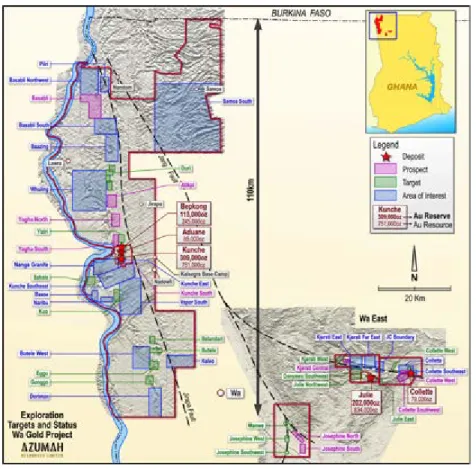
Wa Gold Project – Key Deposits and Prospects
Page 7 of 16
Wa Gold Project – Key Prospects, Targets and Areas of Interest
Table 1: Ore Reserves Summary - August 2014
Ore Reserves Summary
(As atAugust 2014)
Proved Probable Total Gold To Mill
Tonnes
(Mt) Grade g/t Au Tonnes (Mt) Grade g/t Au Tonnes (Mt) Grade g/t Au Oz Au
Kunche 4.91 1.92 0.05 3.11 4.97 1.94 309,000
Bepkong 1.79 1.84 0.11 1.97 1.90 1.85 113,000
Julie 0.29 2.45 1.93 2.89 2.21 2.84 202,000
Total 7.00 1.92 2.09 2.85 9.08 2.14 624,000
Values have been rounded
NB: The Ore Reserve excludes 28,000oz gold deemed ‘Mining Inventory’
Table 2: Mineral Resource Estimate - August 2014
Cut-off
Measured
Indicated
Inferred
Total
0.5 g/t Au Tonnes (M) Grade g/t Au Gold Oz Tonnes (M) Grade g/t Au Gold Oz Tonnes (M) Grade g/t Au Gold Oz Tonnes (M) Grade g/t Au Gold OzKunche 8.42 1.73 468,000 2.24 1.38 99,000 4.86 1.17 183,000 15.52 1.50 751,000 Bepkong 2.22 1.79 128,000 1.70 1.33 73,000 1.17 1.17 44,000 5.09 1.49 245,000 Aduane 1.77 1.50 85,000 1.77 1.50 85,000 Julie 0.89 1.44 41,000 10.06 1.57 507,000 5.98 1.49 286,000 16.93 1.53 834,000 Collette 1.69 1.45 79000 1.69 1.45 79,000 Total 11.52 1.72 637,000 14.00 1.51 679,000 15.47 1.36 677,000 40.99 1.51 1,994,000
Values have been rounded
Page 8 of 16
Competent Persons’ Statements
The scientific and technical information in this report that relates to the geology of the deposits and exploration results is based on information compiled by Mr Stephen Stone, who is a full-time employee (Managing Director) of Azumah Resources Ltd. Mr Stone is a Member of the Australian Institute of Mining and Metallurgy and has sufficient experience which is relevant to the style of mineralisation and type of deposit under consideration and to the activity which he is undertaking to qualify as a Competent Person as defined in the 2012 Edition of the ‘Australasian Code for Reporting of Exploration Results, Mineral Resources and Ore Reserves’. Mr Stone is the Qualified Person overseeing Azumah’s exploration projects and has reviewed and approved the disclosure of all scientific or technical information contained in this announcement that relates to the geology of the deposits and exploration results.
The scientific and technical information in this report that relates to the in-situ Mineral Resource estimates for the Bepkong and Collette
deposits is based on information compiled by Mr David Williams, who is a geological consultant employed by CSA Global Pty Ltd. Mr Williams
is a Member of the Australian Institute of Geoscientists and the Australian Institute of Mining and Metallurgy and has sufficient experience which is relevant to the style of mineralisation and type of deposit under consideration and to the activity which he is undertaking to qualify as a Competent Person as defined in the 2012 Edition of the ‘Australasian Code for Reporting of Exploration Results, Mineral Resources and Ore Reserves’. Mr Williams has reviewed and approved the disclosure of all scientific or technical information contained in this announcement that relates to the Bepkong and Collette Mineral Resource estimate.
The scientific and technical information in this report that relates to the in-situ Mineral Resource estimates for the Kunche and Aduane
deposits is based on information compiled by Mr Dmitry Pertel, who a full-time employee (Manager - Resources) of CSA Global Pty Ltd. Mr
Pertel is a Member of the Australian Institute of Geoscientists and has sufficient experience which is relevant to the style of mineralisation and type of deposit under consideration and to the activity which he is undertaking to qualify as a Competent Person as defined in the 2012 Edition of the ‘Australasian Code for Reporting of Exploration Results, Mineral Resources and Ore Reserves’. Mr Pertel has reviewed and approved the disclosure of the relevant scientific or technical information contained in this announcement that relates to the Kunche and Aduane Mineral Resource estimates.
The scientific and technical information in this report that relates to Mineral Resources estimates for the Julie deposit is based on information compiled by Mr Brian Wolfe, a Competent Person who is a Member of the Australian Institute of Geoscientists. Mr Wolfe is a consultant to Azumah Resources Limited and is not an employee of the Company. Mr Wolfe has sufficient experience that is relevant to the style of mineralisation and type of deposit under consideration and to the activity being undertaken to qualify as a Competent Person as defined in the 2012 Edition of the ‘Australasian Code for Reporting of Exploration Results, Mineral Resources and Ore Reserves’. Mr Wolfe consents to the inclusion in the report of the Julie Mineral Resources in the form and context in which it appears.
The scientific and technical information in this report that relates to Ore Reserves estimates for the Kunche, Bepkong and Julie deposits is based on information compiled by Mr Linton Kirk, an independent consultant to Azumah Resources Limited. Mr Kirk is a Fellow of the Australasian Institute of Mining and Metallurgy. Mr Kirk has sufficient experience that is relevant to the style of mineralisation and type of deposit under consideration and to the activity being undertaken to qualify as a Competent Person as defined in the 2012 Edition of the ‘Australasian Code for Reporting of Exploration Results, Mineral Resources and Ore Reserves’. Mr Kirk consents to the inclusion in the report of the matters related to the Ore Reserve estimate in the form and context in which it appears.
The scientific and technical information in this report that relates to Process Metallurgy is based on information compiled by Mr Ian Thomas, an independent process consultant to Azumah Resources Limited. Mr Thomas is a member of the Australasian Institute of Mining and Metallurgy. Mr Thomas has sufficient experience that is relevant to the style of mineralisation and type of deposit under consideration and to the activity being undertaken to qualify as a Competent Person as defined in the 2012 Edition of the ‘Australasian Code for Reporting of Exploration Results, Mineral Resources and Ore Reserves’. Mr Thomas consents to the inclusion in the report of the matters related to the metallurgy, specifically the data represented in Table 3 in ASX release dated 2nd September 2014, in the form and context in which it appears.
Forward-Looking Statement
This release contains forward-looking information. Such forward-looking information is often, but not always, identified by the use of words such as “seek”, “anticipate”, “believe”, “plan”, “estimate”, “expect” and “intend”, and statements that an event or result “may”, “will”, “should”, “could”, or “might” occur or be achieved, and other similar expressions. In providing the forward-looking information in this news release, the Company has made numerous assumptions regarding: (i) the accuracy of exploration results received to date; (ii) anticipated costs and expenses; (iii) that the results of the feasibility study continue to be positive; and (iv) that future exploration results are as anticipated.
Management believes that these assumptions are reasonable. Forward-looking information is subject to known and unknown risks, uncertainties and other factors that could cause actual results to differ materially from those contained in the forward-looking information. Forward-looking information is based on estimates and opinions of management at the date the statements are made.
Continued:
Page 9 of 16
Appendix 1: Wa Gold Project - JORC Code 2012 Edition – Table 1
Section 1 Sampling Techniques and Data
Criteria JORC Code explanation Commentary
Sampling
techniques Nature and quality of sampling (eg cut channels, random chips, or specific specialised industry standard measurement tools appropriate to the minerals under investigation, such as down hole gamma sondes, or handheld XRF instruments, etc). These examples should not be taken as limiting the broad meaning of sampling.
The sampling described in this report refers to samples from power auger drilling and rock chip sampling.
For the Auger drilling, the thickness of the regolith horizons were recorded, with samples from each layer screened with a hand-held XRF analyser in the field. Approximately 1-2kg of sample was collected by scoop from the drill spoil piles from the bottom of the hole, which was the interface between the regolith and weathered bedrock. Drill holes which did not penetrate the transported cover were not sampled. The bottom of hole samples from the auger drilling were sent to SGS laboratories in Tarkwa for bleg analysis BLL61N, using cyanide extraction of a 2kg bulk sample with ICP-MS finish, with a detection limit of 1ppb.
Rock samples are collected by hand as grab samples
of potentially mineralised outcrop. Approximately 1-2kg of sample was collected and sent as a whole to the laboratory for analysis.
Include reference to measures taken to ensure sample representivity and the appropriate calibration of any measurement tools or systems used.
Aspects of the determination of mineralisation that are Material to the Public Report. In cases where ‘industry standard’ work has been done this would be relatively simple (eg ‘reverse circulation drilling was used to obtain 1 m samples from which 3 kg was pulverised to produce a 30 g charge for fire assay’). In other cases more explanation may be required, such as where there is coarse gold that has inherent sampling problems. Unusual commodities or mineralisation types (eg submarine nodules) may warrant disclosure of detailed information
Appropriate quality assurance/quality control (QAQC) protocols were followed, including submission of field duplicates and insertion of commercial standards for all types of sampling.
Field duplicates, certified standards and blank samples were inserted at a ratio of 1:50 samples. Sample preparation at the laboratory included:
• Drying the sample at 105oC for 4 hours.
• Crushing the sample to less than -6mm (if required).
• Splitting the sample using a riffle splitter.
Pulverising the sample for 4 minutes to achieve 85% of sample passing -75μm in grain size.
Drilling
techniques Drill type (eg core, reverse circulation, open-hole hammer, rotary air blast, auger, Bangka, sonic, etc) and details (eg core diameter, triple or standard tube, depth of diamond tails, face-sampling bit or other type, whether core is oriented and if so, by what method, etc).
All auger holes were drilled using an Azumah owned and operated landcruiser mounted power auger fitted with a standard auger blade bit and auger flutes, up which the sample travels to the surface. All auger holes were vertical and targeted the lower saprolite/upper saprock.
Drill sample
recovery Method of recording and assessing core and chip sample recoveries and results assessed. Provisions are made to log sample recovery and quality by the geologist on site.
Measures taken to maximise sample recovery and
ensure representative nature of the samples. The trained drilling and sampling crew limit the sample loss and wall contamination through careful rotation of the auger bit and flutes, resulting in acceptable sample recovery and clear differentiation of lithology horizons.
Whether a relationship exists between sample recovery and grade and whether sample bias may have occurred due to preferential loss/gain of
Sample recovery was the same for all samples.
Page 10 of 16
fine/coarse material.
Logging Whether core and chip samples have been
geologically and geotechnically logged to a level of detail to support appropriate Mineral Resources
Auger drilling, trenching and rock samples are not used in Mineral Resource Estimation.
However, all samples were logged geologically and have been incorporated into the Azumah Resources database.
Whether logging is qualitative or quantitative in nature. Core (or costean, channel, etc) photography.
All logging is done in a qualitative nature, and photographs taken of all drill spoils and trench walls.
If non-core, whether riffled, tube sampled, rotary
split, etc and whether sampled wet or dry. Auger samples were collected by scoop from the drill spoil piles.
Trench samples are collected by scoop from a continuous channel sample.
Samples were generally dry.
Sub-sampling techniques and sample
preparation
For all sample types, the nature, quality and appropriateness of the sample preparation technique.
Samples were collected in the field by scoop. The entire sample was sent for analysis, so no sub-sampling was required.
Samples were crushed to -6mm and riffle or cone split to obtain a representative fraction. Samples were then dried and ground to 85% passing 75 microns using laboratory mills for FAA505 of BLL61N analysis.
Quality control procedures adopted for all sub-sampling stages to maximise representivity of samples.
Field QA/QC procedures included insertion of field duplicates and commercial standards for auger and trench drilling. Standards, duplicates and blanks were inserted in every batch (1 per 50 samples). Laboratory QA/QC procedures included:
• Every 50th sample was screened to check grinding results (% passing 2mm and 75 microns).
• 1 reagent blank was inserted every 50 samples, 1 preparation process blank was inserted every 50 samples and 1 weighed replicate was inserted every 50 samples.
• 1 preparation duplicate (re-split) every 50 samples and 2 certified reference materials (CRMs) every 50 samples.
Repeat analyses are completed whenever an analytical batch fails to meet the laboratory standards or when requested by a client.
Measures taken to ensure that the sampling is representative of the in situ material collected, including for instance results for field duplicate/second-half sampling
Duplicate samples are taken for all drilling and trenching. The duplicate versus original sample results is considered satisfactory.
Whether sample sizes are appropriate to the grain
size of the material being sampled Sample size is considered appropriate.
Quality of assay data and laboratory tests
The nature, quality and appropriateness of the assaying and laboratory procedures used and whether the technique is considered partial or total.
Auger programmes conducted before May 2014 were analysed by aqua regia digestion with low level Au AAS finish, which is considered appropriate for geochemical sampling.
Auger programmes conducted after June 2014 were analysed by cyanide extraction of a bulk 2kg sample, with low level Au AAS finish, which is considered appropriate for geochemical sampling.
For geophysical tools, spectrometers, handheld
XRF instruments, etc, the parameters used in All samples were analysed using a hand held Innov-X XRF analyser, however this data is qualitive, and for Page 11 of 16
determining the analysis including instrument make and model, reading times, calibrations factors applied and their derivation, etc.
exploration purposes only and would not be used for Mineral Resource Estimation.
Nature of quality control procedures adopted (eg standards, blanks, duplicates, external laboratory checks) and whether acceptable levels of accuracy (ie lack of bias) and precision have been established.
Field QA/QC procedures included the insertion of field duplicates, blanks and commercial standards.
Verification of sampling and assaying
The verification of significant intersections by either
independent or alternative company personnel. All assay results were received electronically from the laboratory and digitally merged into the database.
The use of twinned holes. Twinned holes are not practised in auger drilling or
trenching.
Documentation of primary data, data entry procedures, data verification, data storage (physical and electronic) protocols.
Field data was all recorded as hard copies. Geological logging and sample intervals were recorded in digital form using a logging computer or Excel templates. This data was imported into a SQL database for validation and QC. The analytical data was imported into SQL database with all related metadata and QA/QC information.
Discuss any adjustment to assay data. No adjustments were made, other than for values
below the assay detection limit. These values have been entered as the negative of the detection limit.
Location of data
points Accuracy and quality of surveys used to locate drill holes (collar and down-hole surveys), trenches, mine workings and other locations used in Mineral Resource estimation.
The collar, trench and rock locations of all holes are initially surveyed using a hand-held GPS (accurate to ±2m).
Specification of the grid system used. The grid system is WGS84 Zone 30 North.
Quality and adequacy of topographic control. The topographic surfaces of all properties were
created using a GeoEye image and Digital Surface Model. This was corrected and validated using DGPS drill hole points collected in the field.
Data spacing
and distribution Data spacing for reporting of Exploration Results. Auger holes were drilled 50m apart, with line spacing between 50m and 1,200m.
Whether the data spacing and distribution is sufficient to establish the degree of geological and grade continuity appropriate for the Mineral Resource and Ore Reserve estimation procedure(s) and classifications applied.
Auger drilling and trenching is not used in Mineral Resource Estimation.
Whether sample compositing has been applied. Trench samples are either 1m or 2m composites.
Auger samples were single point samples from the bottom of hole.
Orientation of data in relation to geological structure
Whether the orientation of sampling achieves unbiased sampling of possible structures and the extent to which this is known, considering the deposit type.
The trenches and auger fences are designed perpendicular to the targeted structure.
If the relationship between the drilling orientation and the orientation of key mineralised structures is considered to have introduced a sampling bias, this should be assessed and reported if material.
No orientation based sampling bias has been identified in the data based on the interpreted mineralised structures.
Sample security The measures taken to ensure sample security. Chain of Custody is managed by Azumah staff
(geologists and technicians). Samples are stored on site and delivered to the SGS Laboratory at Tarkwa. Samples submission sheets are in place to track the progress of every batch of samples.
Audits or The results of any audits or reviews of sampling Sampling techniques are consistent with industry
Page 12 of 16
reviews techniques and data. good practice. Data was validated by CSA Global during loading into the database. Checks included Depth from Depth to, sample interval hole depth and overlapping sample intervals. Any data which failed the checking process is returned to Azumah for validation. Global consistency was also checked at a later stage by plotting holes on sections using the database and reconciling assays against the geology.
Section 2: Reporting of Exploration Results
(Criteria listed in the preceding section also apply to this section.)
Criteria JORC Code explanation Commentary
Mineral tenement and land tenure status
Type, reference name/number, location and ownership including agreements or material issues with third parties such as joint ventures, partnerships, overriding royalties, native title interests, historical sites, wilderness or national park and environmental settings.
Work programmes in this report are located in the following leases:
• Piiri – PL 10/37
• Basabli NW – PL10/13
• Butele – Belendari – PL10/18, 36 & 40
• Manwe – PL 10/9
• Duri – PL10/14, PL10/13, PL10/41
• Julie Far East PL10/4
All license areas are located in the Upper West Region in the north-west corner of Ghana.
The security of the tenure held at the time of reporting along with any known impediments to obtaining a licence to operate in the area.
The tenements are in good standing with no known impediments.
Exploration done
by other parties Acknowledgment and appraisal of exploration by other parties. Previous mapping and exploration works were completed by BHP-Utah (1990's), AGEM (late 1990’s) and Semafo (late 1990’s). All exploration activities have been completed by Azumah since 2006.
Geology Deposit type, geological setting and style of
mineralisation. The Project covers approximately 70% of the Palaeoproterozoic Upper and Lower Birimian units,
typically known as the Wa-Lawra greenstone belt, within Ghana. Gold mineralisation occurs as follows:
Kunche: Brittle quartz lode/breccia-hosted with
higher grade Au mineralisation associated with zones of intense silicification, smokey quartz veins, arsenopyrite and pyrrhotite.
Bepkong and Aduane: Increased ductile shearing
and dismemberment of quartz veins. Greater than 1 g/t Au mineralisation occurs within translucent quartz veins and arsenopyrite.
Julie: Quartz veining and lodes within sheared
granodiorite host. Au mineralisation is associated with silicification, pyrite, chalcopyrite, carbonate, sericite and haematite alteration.
Collette: Quartz veining with at least 3 orientations.
Au mineralisation is associated with silicification, arsenopyrite, pyrite, haematite alteration and glassy translucent quartz veining.
Drill Hole
Information A summary of all information material to the understanding of the exploration results including a tabulation of the following information for all
Details of individual auger holes, rocks and trenches are not tabulated here, as the information required for understanding and interpreting the geochemical
Page 13 of 16
Material drill holes:
• easting and northing of the drill hole collar
• elevation or RL (Reduced Level – elevation
above sea level in metres) of the drill hole collar
• dip and azimuth of the hole
• down hole length and interception depth
• hole length.
If the exclusion of this information is justified on the basis that the information is not Material and this exclusion does not detract from the understanding of the report, the Competent Person should clearly explain why this is the case.
results of this type is contained in the maps presented in the report, which show hole and trench locations, and assay results in representative value ranges.
Data aggregation
methods In reporting Exploration Results, weighting averaging techniques, maximum and/or minimum grade truncations (eg cutting of high grades) and cut-off grades are usually Material and should be stated.
No average weighting or cut offs have been applied to the data in this report.
Where aggregate intercepts incorporate short lengths of high grade results and longer lengths of low grade results, the procedure used for such aggregation should be stated and some typical examples of such aggregations should be shown in detail.
No applicable
The assumptions used for any reporting of metal
equivalent values should be clearly stated. No applicable
Relationship between mineralisation widths and intercept lengths
These relationships are particularly important in
the reporting of Exploration Results. No applicable
If the geometry of the mineralisation with respect to the drill hole angle is known, its nature should be reported.
No applicable
If it is not known and only the down hole lengths are reported, there should be a clear statement to this effect (eg ‘down hole length, true width not known’).
No applicable
Diagrams Appropriate maps and sections (with scales) and
tabulations of intercepts should be included for any significant discovery being reported. These should include, but not be limited to a plan view of drill hole collar locations and appropriate sectional views.
Refer to diagrams in body of text.
Balanced reporting Where comprehensive reporting of all Exploration Results is not practicable, representative reporting of both low and high grades and/or widths should be practiced to avoid misleading reporting of Exploration Results.
The ranges displayed on the maps in this report are considered acceptable for exploration purposes. All relevant exploration data has been included in the maps.
Other substantive
exploration data Other exploration data, if meaningful and material, should be reported including (but not limited to): geological observations; geophysical survey results; geochemical survey results; bulk samples – size and method of treatment; metallurgical test results; bulk density,
Geochemistry:
Surface sampling, mapping and geochemistry were completed by BHP and Azumah.
The geochemical database contains data for 51,680 soil samples and 228,673m of combined auguring
Page 14 of 16
groundwater, geotechnical and rock characteristics; potential deleterious or contaminating substances.
and AC drilling.
Airborne Geophysics:
A high resolution aeromagnetic and radiometric survey was completed over the central region of the Wa-Lawra Belt (over the Vapor PL) with line spacing of 100m and sensor height of 40m. The Wa-Lawra Belt geophysical data has been interpreted at 1:100,000 scale by Southern Geoscience Ltd. The processed imagery has provided a base for a new regional geological interpretation.
Ground Geophysics:
Magnetics: A ground magnetic survey conducted in 2006 was plagued by data acquisition problems and the data were rejected as being of insufficient quality for interpretation.
Induced Polarisation:
SAGAX Afriques completed a gradient induced polarisation survey (IP) over the Kunche and Bepkong deposits. The anomalies were interpreted to be caused by disseminated sulphides and quartz veining. The IP survey outlined several linear zones with a similar geophysical response, particularly a prominent linear anomaly west of Kunche. Three dominant orientations were interpreted as a dextral reverse shear model.
Several other geophysical targets were identified and require drill testing.
Metallurgical Test Work:
Extensive metallurgical test work has been undertaken on the Kunche, Bepkong and Julie deposits. There has been only minor work completed on Collette and no work on Aduane. Metallurgical test work performed on the Kunche, Bepkong and Julie ores has included:
• Comprehensive head analysis.
• Comminution.
• Gravity concentration.
• Direct cyanide leaching.
• Carbon kinetics. • Thickening. • Rheology. • Oxygen uptake. • Cyanide detoxification. • Variability testing.
In addition for Julie ore test work has included:
• Bulk sulphide flotation.
• Ultra-fine grinding (UFG) of concentrate.
• Cyanide leaching of UFG flotation concentrate and of flotation tailings.
• QEM*SCAN® analysis of Julie concentrate products.
Collette testing only includes:
• Gravity concentration.
• Direct cyanide leaching.
Page 15 of 16
Potential Deleterious Substances:
Both Kunche and Bepkong mineralisation contains small quantities of organic carbon, arsenic in the form of arsenopyrite, and other sulphide mineralisation.
In general, this does not appear to have a significant deleterious effect on gold extraction. The limited number of Kunche primary variability composites that do exhibit a reduction in extraction have been included in the correlation equation for gold recovery. Preliminary testing indicates the flotation/regrind circuit designed for the Julie primary ore may also benefit some of the Kunche primary ore and further test work is planned on some Kunche primary ore samples.
Julie mineralisation contains sulphides which is predominantly pyrite and relatively unreactive. Approximately 35% of the gold is associated with pyrite which can be recovered by flotation and fine grinding of concentrate prior to extraction by cyanide.
Further work The nature and scale of planned further work (eg
tests for lateral extensions or depth extensions or large-scale step-out drilling).
Further auger drilling is proposed at the following sites:
• Duri relay
• Piiri
• Julie Far East
• Madam’s Farm
• Basabli NW
Follow up aircore or RC drilling is proposed for the following locations:
• Piiri
• Julie Far East
• Yagha N-S
• Kunche Footwall
• Kunche North
• Josephine East
Specific programme details are yet to be decided.
Diagrams clearly highlighting the areas of possible extensions, including the main geological interpretations and future drilling areas, provided this information is not commercially sensitive.
Refer to diagrams in body of text.
Page 16 of 16