N
ATURA
I
MPACT
S
TATEMENT
In Accordance With the Requirements Of
A
RTICLE
6(3)
Of The
EU
H
ABITATS
D
IRECTIVE
For The
A
SHTOWN
/P
ELLETSTOWN
L
OCAL
A
REA
P
LAN
Contents
1.0 Introduction………...………5
1.1 Requirement for Appropriate Assessment……….……….5
1.2 Objectives of the Habitats Directive……….5
1.3 Stages of Appropriate Assessment……….……..……..6
1.4 Guidance Documentation………..7
1.5 Integrating AA Into The Plan Making Process……….………..8
1.6 Dublin City Development Plan Mitigation Measures………...………..9
2.0 Stage 1 Screening………..…………..10
2.1 Desk Study and Site Visit………..………….10
2.2 Location of the Ashtown/Pelletstown Local Area Plan Area………..……10
2.3 Overview of Ashtown/Pelletstown LAP………..…..10
2.4 Key Elements of Ashtown/Pelletstown LAP……….………..…..11
2.5 Screening Steps for Appropriate Assessment……….……12
2.6 Zone of Influence of Ashtown/Pelletstown LAP………..……13
2.7 Identification of Natura 2000 Sites in Surrounding Area………14
2.8 Linkages between LAP and surrounding Natura 2000 Sites………...….15
2.9 Category of Impacts……….…18
2.10 Other development nearby which could lead to cumulative impacts………...22
2.11 Stage One Screening – Conclusion……….……….26
3.0 Stage Two: Appropriate Assessment………26
3.1 Assessment Methodology………..………26
3.2 Natura 2000 Sites……….26
3.3 Potential Impacts of the LAP on Natura 2000 Sites………27
3.4 Implementation of Mitigation Policies and Objectives………31
3.5 Monitoring the Implementation of Policies and Objectives………34
Appendix 1 – Reference List………36 Appendix 2 - Assessment of LAP Policies/Objectives………38 Appendix 3 – Natura 2000 Sites………...56
Map 1 - Ashtown/Pelletstown LAP Area in Context
1.0 Introduction
This Appropriate Assessment (AA) document is part of the Local Area Plan (LAP) making process and should be read in conjunction with the LAP and also the Strategic Environmental Assessment (SEA) for the Ashtown/Pelletstown area. The SEA and AA are complementary processes which overlap and afford opportunity for cooperation.
1.1 Requirement for Appropriate Assessment
Dublin City Council (DCC) has prepared a Local Area Plan (LAP), for Ashtown/Pelletstown (Map 1 & 2) under the Planning and Development Act 2000 (as amended). An LAP sets out planning policies and objectives for a specifically defined area over an initial 6 year period, which may be extended by the local authority, for a period of up to 10 years. The purpose of this Report is to assess potential impacts of the LAP on Natura 2000 sites (Special Areas of Conservation and Special Protection Areas). This report refers only to potential impacts that may occur to any Natura 2000 site as a result of the implementation of the Local Area Plan itself and/or in combination with other plans and/or projects. Under the EU Birds (2009/147/EC) and Habitats (92/43/EEC) Directives, member states are required to designate sites of European Importance in order to protect certain habitats and species. These sites are known as Special Protection Areas (SPA) and Special Areas of Conservation (SAC). Collectively these sites form part of the Natura 2000 Network. Any plan or project that is likely to impact on the integrity of a Natura 2000 site must undergo an Appropriate Assessment (AA) to determine impacts, and where necessary, devise appropriate measures to prevent or minimise any such impacts.
1.2 Objectives of the Habitats Directive
The requirements for an Appropriate Assessment are set out in the EU Habitats Directive, Articles 6(3) and 6(4) which state:
Article 6(3) of the Habitats Directive states:
“Any plan or project not directly connected with or necessary to the management of the [Natura 2000] site but likely to have a significant effect thereon, either individually or in combination with other plans or projects, shall be subject to appropriate assessment of its implications for the site in view of the site's conservation objectives. In the light of the conclusions of the assessment of the implications for the site and subject to the provisions of paragraph 4, the competent national authorities shall agree to the plan or project only after having ascertained that it will not adversely affect the integrity of the site concerned and, if appropriate, after having obtained the opinion of the general public”
Article 6(4) of the Habitats Directive states:
‟If in spite of a negative assessment of the implications for the site and in the absence of alternative solutions, a plan or project must nevertheless be carried out for imperative reasons of overriding public interest, including those of a social or economic nature, the Member State shall take all compensatory measures necessary to ensure that the overall coherence of Natura 2000 is protected. It shall inform the Commission of the compensatory measures adopted. Where the site concerned hosts a priority natural habitat type/or a priority species the only considerations which may be raised are those relating to human health or public safety, to beneficial consequences of primary importance for the environment or, further to an opinion from the Commission, to other imperative reasons of overriding public interest”.
The Habitats Directive promotes a hierarchy of avoidance, mitigation and compensation measures, as summarised below ;
(1) Firstly, a plan should aim to avoid any negative impacts on Natura 2000 sites by identifying possible impacts early in plan making, and writing the plan in order to avoid such impacts.
(2) Secondly, if adverse impacts cannot be avoided, mitigation measures may be applied during the AA process to the point where no significant adverse impacts on the site(s) remain.
(3) Thirdly, under a worst case scenario where even through the application of mitigation measures, significant adverse impacts on the integrity of the site cannot be ruled out, a project or plan may have to undergo an assessment of alternative solutions. Under this stage of the assessment, compensatory measures are required for any remaining adverse effects, but they are permitted only if a) there are no alternative solutions and b) the plan is required for imperative reasons of overriding public interest (the IROPI test). European case law highlights that consideration must be
given to alternatives outside the plan boundary area in carrying out the IROPI test. It is a rigorous test which plans are generally considered unlikely to pass.
1.3 Stages of Appropriate Assessment Stage One: Screening
The process which identifies the likely impacts upon a Natura 2000 site of a project or plan, either alone or in combination with other projects or plans, and considers whether these impacts are likely to be significant.
Stage Two: Appropriate Assessment
The consideration of the impact on the integrity of the Natura 2000 site of the project or plan, either alone or in combination with other projects or plans, with respect to the site’s structure and function and its conservation objectives. Additionally, where there are adverse impacts, an assessment of the potential mitigation of those impacts.
Stage Three: Assessment of Alternative Solutions
The process which examines alternative ways of achieving the objectives of the project or plan that avoid adverse impacts on the integrity of the Natura 2000 site.
Stage Four: Assessment of compensatory measures where adverse impacts remain
An assessment of compensatory measures where, in the light of an assessment of imperative reasons of overriding public interest (IROPI), it is deemed whether the project or plan should proceed.
1.4 Guidance Documentation
The following guidance was consulted in preparing this report:
Appropriate Assessment of Plans and Projects in Ireland. Guidance for Planning Authorities Department of the Environment, Heritage and Local Government 2010.
Assessment of plans and projects significantly affecting Natura 2000 sites: Methodological guidance on the provisions of Article 6 (3) and (4) of the Habitats Directive 92/43/EEC, European Commission Environment DG, 2000.
Managing Natura 2000 sites: The Provisions of Article 6 of the Habitats Directive 92/43/ EEC: European Commission, 2000.
Greater Dublin Strategic Drainage Study - 2005 - River Tolka Flooding Study.
Local Area Plans, Guidelines for Planning Authorities. Department of the Environment, Community and Local Government, 2013.
Dublin City Development Plan 2011-2017
1.5 Integrating AA Into The Plan Making Process
Integration of Appropriate Assessment (AA) in the LAP making process safeguards against significant adverse effects upon Natura 2000 sites.
Ashtown/Pelletstown Local Area Plan & Appropriate Assessment Procedure Local Area Plan (LAP) Process Appropriate Assessment (AA) Process LAP Issues Paper, Public display
and consultation,
(29th June – 10th August 2012)
Screening of general principles of development proposed
LAP Draft Formulated Analysis of Policies & Objectives & preparation of Natura Impact Statement (NIS)
Public Display and consultation regarding Draft LAP
(May 3rd – June 18th 2013)
Finalised NIS of draft LAP produced
Amendments to draft LAP made on foot of public, statutory and councillor submissions,
observations and motions received following public display
Natura Inpact Report (NIR) of proposed amendments to draft LAP produced prior to 2nd September Dublin
City Council meeting. This took the form of a combined NIR encompassing the screening of the Managers Report on Submissions and Managers Report on Councillors Motions.
Dublin City Council resolved to amend draft LAP as per Managers Report at City Council meeting held on the 2nd September 2013
NIR of proposed amendments to draft LAP produced following 2nd September Dublin City Council meeting
with no changes made. (Managers Report was adopted without variation)
Public Display and consultation - proposed amendments to draft LAP and associated documents (September 23rd – October 21st
2013)
NIR of proposed alterations to the draft LAP produced of foot of submissions received
Adoption of LAP by Dublin City Council on 2nd December 2013
Final and updated NIS produced encompassing changes detailed in previous NIR’s into final version.
1.6 Dublin City Development Plan Mitigation Measures
Dublin City Council recognises that the protection and future conservation of designated sites under EU legislation is an important issue for the Local Authority to address, both directly and indirectly. As a result, a comprehensive set of policies and objectives are contained within the Dublin City Development Plan 2011-2017 in relation to the protection and preservation of designated sites under the EU Habitats Directive and the EU Birds Directive. These policies are as follows:
Policy GC26
To protect flora, fauna and habitats, which have been identified by the Habitats Directive, Birds Directive, Wildlife Act 1976 (as amended), the Flora Protection Order (S.I. no. 84 of 1999), and the European Communities (Natural Habitats) Regulations 1997 (S.I. no. 94 of 1997)
Policy GC27
To conserve and manage all Natural Heritage Areas, Special Areas of Conservation and Special Protection Areas identified and designated, or proposed to be designated, by the Department of Environment, Heritage and Local Government. These designations will allow for protection in the event of any approved boundary changes by the Department of Environment, Heritage and Local Government. The following policies, which are set out in the Development Plan, are aimed specifically at protecting the natural environment within the Dublin City Council administrative area, inclusive of the LAP area.
Policy GC28
To seek the conservation and management of areas of natural environmental value. Policy GC29
To conserve priority species, habitats, and natural heritage features identified in the Dublin City Biodiversity Action Plan 2008 - 2012 for priority conservation measures.
Policy GC30
To have regard to the conservation and enhancement of significant non-designated areas of ecological importance in accordance with development standards set out in this plan.
2.0
Stage 1 Screening
2.1 Desk Study and Site Visit
The Screening process included a desktop study as well as a site visit in Summer 2012 by members of the City Council’s Planning Department. The purpose of this was to gain a better understanding of proposed policies and objectives within LAP lands and how these could be incorporated into the plan whilst simultaneously ensuring no adverse impacts to the surrounding Natura 2000 Sites. Potential policies and objectives within the plan and background data including existing Environmental Impact Statements and a range of ecological studies were used to inform the AA.
2.2 Location of Ashtown/Pelletstown Local Area Plan Area
The Ashtown/Pelletstown LAP area is located some 4km northwest of Dublin’s City Centre (see Map 1), between the Tolka River to the north and the Royal Canal to the south and immediately east of the administrative area of Fingal County Council. It occupies a strategic location in regard to the city and provides good public transportation links to the wider metropolitan areas including Dublin City Centre, Dublin Airport and M50. The LAP area would be located approximately 10km upstream, due northwest from Dublin Bay.
2.3 Overview of Ashtown/Pelletstown LAP
The Ashtown/Pelletstown LAP area comprises approximately 62 Ha of land, of which 21.3 hectares having been developed, 17.05 hectares undeveloped and the remainder encompassing Tolka Valley Park and Crescent Park. The majority of development on site is residential with associated retail provision. The vast majority of the lands are zoned Z14 “to seek the social, economic and physical development and/or rejuvenation of an areas with mixed use, of which residential and “Z6” would be the predominant uses. Z6 zoning aims ‘to provide for the creation and protection of enterprise and facilitate opportunities for employment creation’ and it should be noted that the ‘Ormond’ industrial site on the eastern side of the plan area is zoned Z6 only. This LAP builds on the Action Area Plan for Pelletstown (2000) that was drafted by the then Dublin Corporation and provides for the proper planning and sustainable development of the Ashtown/Pelletstown area for a duration of six years from the date of adoption. The aforementioned Action Area Plan envisaged a population of approximately 10,000 residents through the provision of sustainable density residential development. Having regard to the extent of available development lands and the density range outlined in the LAP, an estimated population of between 2490 - 3410 is envisaged and when added to the existing population of 3,777 would yield a population range of 6,267 – 7,187, equating to 6,300 – 7,200 when rounded up. (Figures taken from LAP Housing section).
2.4 Key elements of the Ashtown/Pelletstown LAP
The LAP sets out a progressive plan for physical, environmental and social infrastructure development. The key elements being addressed by this LAP include:
Development of 2 Local Centres, west and east, at Ashtown and Royal Canal nodes.
A new rail station at the eastern end of the Royal Canal development
Development of cross site linkages.
Provision of a mix of residential units with an expected population of 6,300 – 7,200.
Implementation of sustainable urban drainage solutions (SUDS).
Incorporation of existing biodiversity and develop strategic planting.
Protection and preservation any significant archaeological remains.
Development of a ‘Green Infrastructure’ network.
Facilitation of the provision of a school.
Compliance with the Greater Dublin Regional Code of Practice for Drainage works and should comply with the Greater Dublin Strategic Drainage Study (GDSDS).
New layout, planting and paths in Tolka Valley park
The Ashtown/Pelletstown LAP area sits within a hierarchy of land use plans and is intended to provide a localised and focused planning framework for the sustainable regeneration and development of the Ashtown/Pelletstown Area, an outer urban area of Dublin City, within the context of the Dublin City Development Plan 2011-2017, the Regional Planning Guidelines for the Greater Dublin Area 2004 – 2016 and the National Spatial Strategy 2002 – 2020. All of these policy documents support urban regeneration and the minimisation of suburban sprawl. Planning and development issues of a regional and strategic nature, including, for example, wider wastewater treatment capacity, are assessed at a higher level of the planning hierarchy.
The Ashtown/Pelletstown LAP is part of the overall core strategy as set out in the Dublin City Development Plan 2011 - 2017. As part of this core strategy, Dublin City Council will prepare area specific plans for the key developing area (KDAs) and Key District Centres (KDCs), using appropriate mechanisms of local area plans and schematic master plans. The local area plans will be prepared for areas subject to large scale developments over the foreseeable future. Table 3.4 and Table 3.5, of Section 3.2.7 of the Dublin City Development Plan 2011-2017 sets out a schedule of the local area plans/statutory plans to deliver the core strategy.
The Dublin City Development Plan 2011 – 2017 designates 9 key developing areas, one of which is Ashtown/Pelletstown. Table 3.3 of section 3.2.3 of the Development Plan gives estimated residential capacity of the key developing areas. In total over the 9 KDAs, an estimated 31,680 new housing units are proposed, and 1,629 Ha of zoned commercial/employment lands. The estimates under the core strategy for Ashtown/Pelletstown is 1800 housing units, set within the Z14 ‘Regeneration’ zoning, although this number is anticipated to be circa 1300 new housing units, following a re-examination of probable demand and type of unit desired by prospective buyers. There are 2121 units existing already. Census 2011 estimated the average household size in ‘Ashtown A’ Electoral District to be 2.7 persons and any population estimate would be a
combination of this figure times the number of housing units proposed. This entails a regenerative designation encompassing residential and enterprise development, facilitating a core population with associative employment opportunities. It should be noted that a separate Appropriate Assessment and Strategic Environmental Report was undertaken for the Dublin City Development Plan 2011-2017. Each Local Area Plan will be carrying out their individual Appropriate Assessment and Strategic Environmental Assessment screening reports.
2.5 Screening Steps for Appropriate Assessment
All land use plans or strategies that are not directly related to the management of Natura 2000 designated sites, such as this LAP, must be examined to ensure that there will not be any significant adverse effects on such designated sites. These particular sites are regarded to be of European importance and are part of the European Commission’s (EC) Natura 2000 network of sites in Ireland. The Irish Government and local planning authorities have a legal obligation to protect these sites.
The process of assessing the Plan is a structured exercise with a series of steps. The overall purpose of the process is to ensure that the Plan, when implemented, does not result in adverse effects on the “integrity” of Natura 2000 sites. The overall process is termed “Appropriate Assessment”, using the terms set out in the EC Habitats Directive Article 6(3). There are two distinct stages of the Appropriate Assessment process:
Stage 1 – Screening
Stage 2 – Appropriate Assessment (which results in the publication of the Natura Impact Report)
These two stages are within the overall “Appropriate Assessment Process”. The first step is to look at the Plan in principle and to answer the questions: is it likely that the implementation of this Plan could result in likely significant effects on Natura sites? It does not matter where these sites may be – impacts can occur across administrative boundaries. This step is known as Screening for Appropriate Assessment.
If the screening stage results in a judgement that likely significant effects may occur or cannot be ruled out, then a more detailed ‘Appropriate Assessment’ (AA) is required. Whilst the structure of this assessment process is not specified in the legislation, there are guidance documents that are used to provide an indication of how this assessment may be carried out. (See Section 3.0)
The Screening Stage determined that due to the types of development that could arise as a result of implementing the Local Area Plan, significant effects could not be ruled out and that the Plan would need further assessment, that is, Stage 2 – Appropriate Assessment. Prior to this stage a scoping exercise was conducted that further examined that area where impacts could arise from. In this instance screening identified hydrology as the issue which could impact Natura 2000 sites and scoping determined that water borne pollutants/contaminants were the potential specific threat.
Stage 2 involved analysing the relationship between the proposed policies and objectives in the Local Area Plan and the sensitivities of the Natura 2000 sites. Where there was potential for an impact to occur then changes were made to policies and objectives of the Plan to avoid or mitigate the potential impact. These recommendations were integrated into the Draft Plan so that the implementation of the Final Plan will not result in any significant adverse effects on Natura 2000 sites.
2.6 Zone of Influence of Ashtown/Pelletstown LAP
A typical LAP will encompass an extensive physical area with ongoing, phased development over a sustained period of time. Such a scenario can have unforeseen impacts in ecological terms, i.e. increased danger of flooding due to laying of hard surfaces or pollution of existing water courses. Therefore it is necessary to screen for potential ecological impacts on sensitive nature sites that fall within the Zone of Influence (ZoI) of the project or plan. The ZoI is the ‘effect area’ over which changes could give rise to potentially significant impacts, as per National Roads Authorities Guidelines for Assessment of Ecological Impacts of National Roads Schemes (NRA, 2009). The ZoI over which significant impacts may occur will differ for sensitive ecological receptors depending on the pathway for any potential impacts, as well as the specific nature of different habitats/species (e.g. ability to move/disperse or absorb impacts). In accordance with guidance from the Department of Environment, Heritage and Local Government (2010) a distance of 15km was used as a starting point for identifying potential impacts, though this distance can be extended, if there are potential impacts that can range outside a 15 km area.
Hydrological linkages (e.g. rivers, groundwater flows) between impact sources and aquatic habitats and species often result in impacts occurring at significant distance from the source of impact. The distances over which water-borne pollutants are likely to remain in sufficient concentrations to have a significant impact on receiving waters is difficult to quantify and highly site-specific. Evidently, it will depend on volumes of discharged waters, concentrations and types of pollutants, volumes of receiving waters, and sensitivity of receiving waters. In order to understand the ZoI for this LAP in the context of Appropriate Assessment, it is useful to explain the hydrological interconnectivity. The River Tolka runs along the northern boundary of the LAP lands and is a tributary of the River Liffey which in turn flows into Dublin Bay. There are a number of Natura 2000 sites within Dublin Bay that therefore are hydrologically connected to the LAP area. These Natura 2000 sites are located some distance downstream from the LAP area yet fall within its identified potential zone of influence. The Royal Canal runs along the southern boundary adjacent to the rail line and links the midlands with the city and links with Dublin Bay through the Liffey at Docklands. It is designated as a proposed Natural Heritage Area (pNHA).
2.7 Identification of Natura 2000 Sites in Surrounding Area
For the purposes of this AA the 15km ZoI distance was deemed to be sufficient to cover all likely significant effects which may arise from the implementation of the LAP on Natura 2000 sites, inclusive of any new designations as of March 2013.
The Natura 2000 sites within a 15km radius of the LAP area are;
North Bull Island SPA (IE004006)*
South Dublin Bay & River Tolka Estuary SPA (IE004024)
Baldoyle Bay SPA(IE004016)
Dalkey Islands SPA (IE004172)
Baldoyle Bay SAC (IE00199)
North Dublin Bay SAC (IE00206)
South Dublin Bay SAC (IE00210)
Rockabill to Dalkey Island SAC (IE003000)
Malahide Estuary SAC (IE000205)
Malahide Estuary SPA (IE004025)
*The number in brackets is the National Parks and Wildlife Service site code.(www.npws.ie, 2013)
In addition to the Natura 2000 Sites within the Zol there are seven proposed Natural Heritage Areas (pNHAs) in and adjoining the LAP area. Although NHAs/pNHAs do not form part of the Natura 2000 network they have been included here for the potential support that they may provide to the Natura 2000 network.
Royal Canal pNHA
North Dublin Bay pNHA
South Dublin Bay pNHA
Dolphins pNHA, Dublin Docks (the term ‘dolphins’ refers to mooring devices located near Pigeon House Harbour and used by nesting terns)
Baldoyle Bay pNHA
Dalkey Coastal Zone and Killiney Hill pNHA
Map 3 – Location of Natura 2000 Sites
2.8 Linkages between LAP and Surrounding Natura 2000 Sites
There are many and varied potential threats to species and habitats contained within Natura 2000 sites, they may include but are not limited to;
Activity, noise, light
Increased traffic leading to increased air pollution
Water quality and hydrological changes including increased use of water and increased run off of surface water
Increased visits to the Natura 2000 sites, possibly with associated disturbance of fauna and impacts upon habitats
Damage to undesignated land functionally linked to sites, e.g. roost sites and foraging areas used by SPA birds
Wind energy development, e.g. collision mortality, disturbance and displacement.
Disturbance to SPA species caused by the construction and operation of developments
All Natura 2000 sites which fall within 15km of the LAP boundary are listed in Section 2.7 and are illustrated in Map 3. In order to identify those sites that could be potentially affected, it was necessary to describe the Natura 2000 site in the context of why it has been designated, otherwise know as its “Qualifying Interests” and the environmental and ecological conditions that maintain the condition of these features. The Qualifying Interests and threats to the sites were extracted from the NPWS website database (www.npws.ie, 2013) and are detailed in Table 1.Given that the LAP area has no direct links to the Natura 2000 sites and the nature of LAP area being non industrial and consisting of residential and commercial developments, the main indirect linkages are hydrological. These linkages/pathways are described below.
Tolka River
The Tolka River is the main hydrological link between the LAP area and the Natura 2000 sites located downstream, which are deemed to be within the Zol. The Tolka River rises east of Dunshaughlin, Co. Meath, and by-passes Dunboyne, from where it receives the Castle Stream tributary. From Clonee, where it is joined by the Clonee Stream, it flows into County Dublin. The river continues through Damastown and Mulhuddart, Blanchardstown, and Ashtown (south of Finglas), and then the north Dublin suburban districts of Glasnevin and Drumcondra where it comes closest to the Royal Canal near Binn's Bridge. At the southern side of Tolka Park it forms the border between Ballybough and Fairview, before entering Dublin Bay between East Wall and Clontarf.
The Tolka River floods infrequently. Notable floods occurred in October 1880, December 1954, November 1965, August 1986 (Hurricane Charlie), November 2000, November 2002, January and April 2005, August 2008 and October 2011; those of 1954 and 2002 were the most severe, (Water Pollution Control Unit, DCC). In November 2002, flooding caused extensive damage to residential areas along the Tolka banks. After this, much work was done to strengthen the river's flood defenses, and following heavy flooding in 2005, major works to deepen and widen the river were carried out on a number of stretches most notably at Glasnevin Woods and at Drumcondra Bridge.
In relation to water quality, the River Tolka near Ashtown/Pelletstown has poor status under Water Framework Directive, as measured against Water Framework Directive criteria, (Water Pollution Control Unit, DCC). This classification is based on poor status for fish and macroinvertebrates, and moderate status for general physicochemical parameters, (Water Pollution Control Unit, DCC). The principal pressures on the river at this location are upstream agricultural activities, discharges from combined sewer overflows on Blanchardstown and Abbotstown and urban runoff, (Water Pollution Control Unit, DCC). If the Ashtown/Pelletstown development is fully completed, there is risk that urban runoff from the site will significantly increase unless mitigation measures are provided.
Royal Canal
The Royal Canal is a Proposed Natural Heritage Area (pNHA) under the 1976 Wildlife Act and is one of the principal water bodies within the LAP boundary. The Royal Canal is defined by the National Parks and Wildlife Service (NPWS) to include the central channel and adjoining banks, hedgerows, tow path, grassland, open water, related scrub and woodland features. Water quality is not affected by the current development due to the implementation of the range of SuDS initiatives that have been implemented as part of recent development. The results from the EPA 1998-2000 surveys showed that the water quality in both canals was good with low levels of conductivity and nutrients. Water quality in the Royal Canal was generally good during 2009 (EPA, 2013). www.epa.ie
2.9 Category of Impacts
With regard to the LAP, the issues listed below include those with potential to impact upon Natura 2000 Sites as described in Section 2.7. Given the hydrological linkages, water related issues are to the fore, although potential impacts on habitats and species also exist due to a potential increase in visitor numbers to the coastal areas via pedestrian and cycle pathways being constructed. (Highlighted sites, in purple, are those liable to impacts)
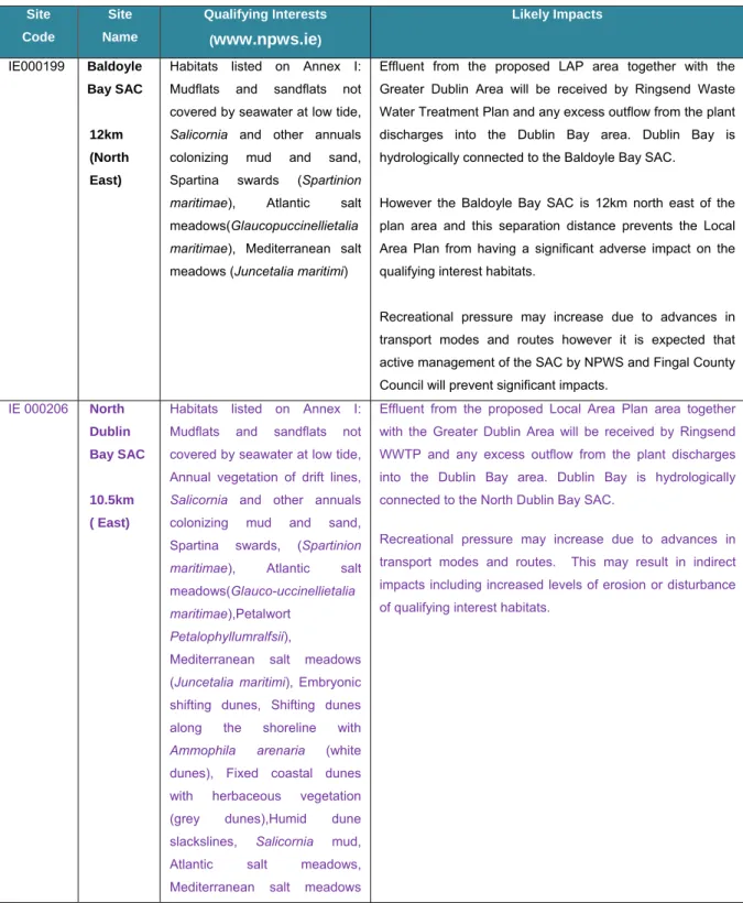
Table 1 - Natura 2000 Sites and Potential Impacts from LAP Site Code Site Name Qualifying Interests (www.npws.ie) Likely Impacts IE000199 Baldoyle Bay SAC 12km (North East)
Habitats listed on Annex I: Mudflats and sandflats not covered by seawater at low tide,
Salicornia and other annuals colonizing mud and sand, Spartina swards (Spartinion maritimae), Atlantic salt meadows(Glaucopuccinellietalia maritimae), Mediterranean salt meadows (Juncetalia maritimi)
Effluent from the proposed LAP area together with the Greater Dublin Area will be received by Ringsend Waste Water Treatment Plan and any excess outflow from the plant discharges into the Dublin Bay area. Dublin Bay is hydrologically connected to the Baldoyle Bay SAC.
However the Baldoyle Bay SAC is 12km north east of the plan area and this separation distance prevents the Local Area Plan from having a significant adverse impact on the qualifying interest habitats.
Recreational pressure may increase due to advances in transport modes and routes however it is expected that active management of the SAC by NPWS and Fingal County Council will prevent significant impacts.
IE 000206 North Dublin Bay SAC
10.5km ( East)
Habitats listed on Annex I: Mudflats and sandflats not covered by seawater at low tide, Annual vegetation of drift lines,
Salicornia and other annuals colonizing mud and sand, Spartina swards, (Spartinion maritimae), Atlantic salt meadows(Glauco-uccinellietalia maritimae),Petalwort
Petalophyllumralfsii),
Mediterranean salt meadows (Juncetalia maritimi), Embryonic shifting dunes, Shifting dunes along the shoreline with
Ammophila arenaria (white dunes), Fixed coastal dunes with herbaceous vegetation (grey dunes),Humid dune slackslines, Salicornia mud, Atlantic salt meadows, Mediterranean salt meadows
Effluent from the proposed Local Area Plan area together with the Greater Dublin Area will be received by Ringsend WWTP and any excess outflow from the plant discharges into the Dublin Bay area. Dublin Bay is hydrologically connected to the North Dublin Bay SAC.
Recreational pressure may increase due to advances in transport modes and routes. This may result in indirect impacts including increased levels of erosion or disturbance of qualifying interest habitats.
Site Code Site Name Qualifying Interests (www.npws.ie) Likely Impacts
and Tidal mudflats. Fixed dunes are listed with priority status. IE000210 South Dublin Bay SAC 8.75km (South East)
Habitats listed on Annex I: Tidal mudflats and sandflats.
Effluent from the proposed Local Plan Area together with the Greater Dublin Area will be received by Ringsend WWTP and any excess outflow from the plant discharges into the Dublin Bay area. South Dublin Bay SAC is contained within Dublin Bay
Recreational pressure may increase due to advances in transport modes and routes. This may result in indirect impacts including increased levels of disturbance of qualifying interest habitats.
IE004006 North Bull Island SPA 10.5km (North East)
Species: Light-bellied Brent Goose, Shelduck, Pintail, Shoveler, Oystercatcher, Grey Plover, Knot, Dunlin, Black-tailed Godwit, Bar-Black-tailed Godwit Redshank, Turnstone
Teal, Ringed Plover, Golden Plover, Sanderling, Curlew, Black headed Gull and wetland & waterbirds
Effluent from the proposed Local Area Plan Area together with the Greater Dublin Area will be received by Ringsend WWTP and any excess outflow from the plant discharges into the Dublin Bay area. North Bull Island SPA.is contained within the Dublin Bay area.
Recreational pressure may increase due to advances in transport modes and routes. This may result in indirect impacts including increased disturbance levels from recreational activities including dog walkers.
IE004016 Baldoyle Bay SPA
9km (North East)
Species: Light-bellied Brent Goose, Ringed Plover and Bartailed Godwit, Shelduck, Golden Plover, Grey Plover and Wetlands.
Effluent from the proposed Local Area Plan area together with the Greater Dublin Area will be received by Ringsend WWTP and any excess outflow from the plant discharges into the Dublin Bay area. Dublin Bay is hydrologically connected to the Baldoyle Bay SPA.
However the Baldoyle Bay SPA is 9km north east of the plan area and this separation distance prevents the Local Area Plan from having a significant adverse impact on the qualifying interests.
Recreational pressure may increase due to advances in transport modes and routes. This may result in indirect impacts including increased disturbance levels from recreational activities including dog walkers. However due to the distance of 9km between the two sites and active management of the Baldoyle Bay SPA by NPWS and Fingal County Council, any potential indirect impacts from recreational activities are considered unlikely to result in adverse impacts.
IE004024 South Dublin Bay And
Species: Light-bellied Brent Goose, Oystercatcher, Ringed Plover, Grey Plover, Knot,
Effluent from the proposed Local Area Plan area together with the Greater Dublin Area will be received by Ringsend WWTP and any excess outflow from the plant discharges
Site Code Site Name Qualifying Interests (www.npws.ie) Likely Impacts River Tolka Valley Estuary SPA 1.7km (East)
Dunlin, Sanderling, Bar-tailed Godwit, Redshank, Black headed Gull, Roseate Tern, Common Tern, Arctic Tern and Wetland & Waterbirds
into the Dublin Bay area. Dublin Bay is hydrologically connected to the South Dublin Bay and River Tolka Valley Estuary SPA.
Recreational pressure may increase due to advances in transport modes and routes. This may result in indirect impacts including increased disturbance levels from recreational activities including dog walkers.
IE004025 Malahide Estuary SPA 13km (North East)
Species: Light-bellied Brent Goose, Golden eye and Black-tailed Godwit. Additional Special Conservation Interests include: Great Crested Grebe, Shelduck, Pintail, Red Breasted Merganser, Oystercatcher, Golden Plover, Grey Plover, Knot, Dunlin, Bartailed Godwit, Redshank and Wetland & Waterbirds
Effluent from the proposed Local Area Plan area together with the Greater Dublin Area will be received by Ringsend WWTP and any excess outflow from the plant discharges into the Dublin Bay area. Dublin Bay is hydrologically connected to the Malahide Estuary SPA.
However the Malahide Estuary SPA is 13km north east of the plan area and this separation distance prevents the Local Area Plan from having a significant adverse impact on the qualifying interest habitats.
Recreational pressure may increase due to advances in transport modes and routes however it is expected that active management of the SPA by NPWS and Fingal County Council will prevent significant impacts. In addition the separation distance of 13km between the two areas will reduced the magnitude of any potential negative impacts on the SPA. IE004172 Dalkey Islands SPA 12km (South East)
Species: Roseate Tern, Common Tern, Arctic Tern.
Effluent from the proposed Local Area Plan area together with the Greater Dublin Area will be received by Ringsend WWTP and any excess outflow from the plant discharges into the Dublin Bay area. Dublin Bay is hydrologically connected to the Dalkey Islands SPA.
Due to the distance between the two sites and location offshore, no adverse impacts from the LAP area are envisaged. IE000205 Malahide Estuary SAC 13km (North)
Habitats listed on Annex I: Fixed Coastal Dunes with Herbaceous Vegetation (Grey Dunes), Mudflats & Sand flats not covered by seawater at low tide, Atlantic Salt Meadows, Spartina Swards, Mediterranean Salt Meadows, Salicornia & other annuals colonising mud and sand and Shifting Dunnes along
Effluent from the proposed Local Area Plan area together with the Greater Dublin Area will be received by Ringsend WWTP and any excess outflow from the plant discharges into the Dublin Bay area. Dublin Bay is hydrologically connected to the Malahide Estuary SAC.
However the Malahide Estuary SAC is 13km north of the plan area and this separation distance prevents the Local Area Plan from having a significant adverse impact on the
Site Code Site Name Qualifying Interests (www.npws.ie) Likely Impacts
the shore line with Ammophila arenaria (White Dunes).
qualifying interest habitats.
Recreational pressure may increase due to advances in transport modes and routes however it is expected that active management of the SAC by NPWS and Fingal County Council will prevent significant impacts.
In addition the separation distance of 13km between the two areas will reduced the magnitude of any potential negative impacts on the SAC.
IE003000 Rockabill to Dalkey Islands SAC 9km (East)
Annex I: reefs and Annex II Harbour Porpoise.
Effluent from the proposed Local Area Plan area together with the Greater Dublin Area will be received by Ringsend WWTP and any excess outflow from the plant discharges into the Dublin Bay area. Dublin Bay is hydrologically connected to the Rockabill to Dalkey Islands SAC
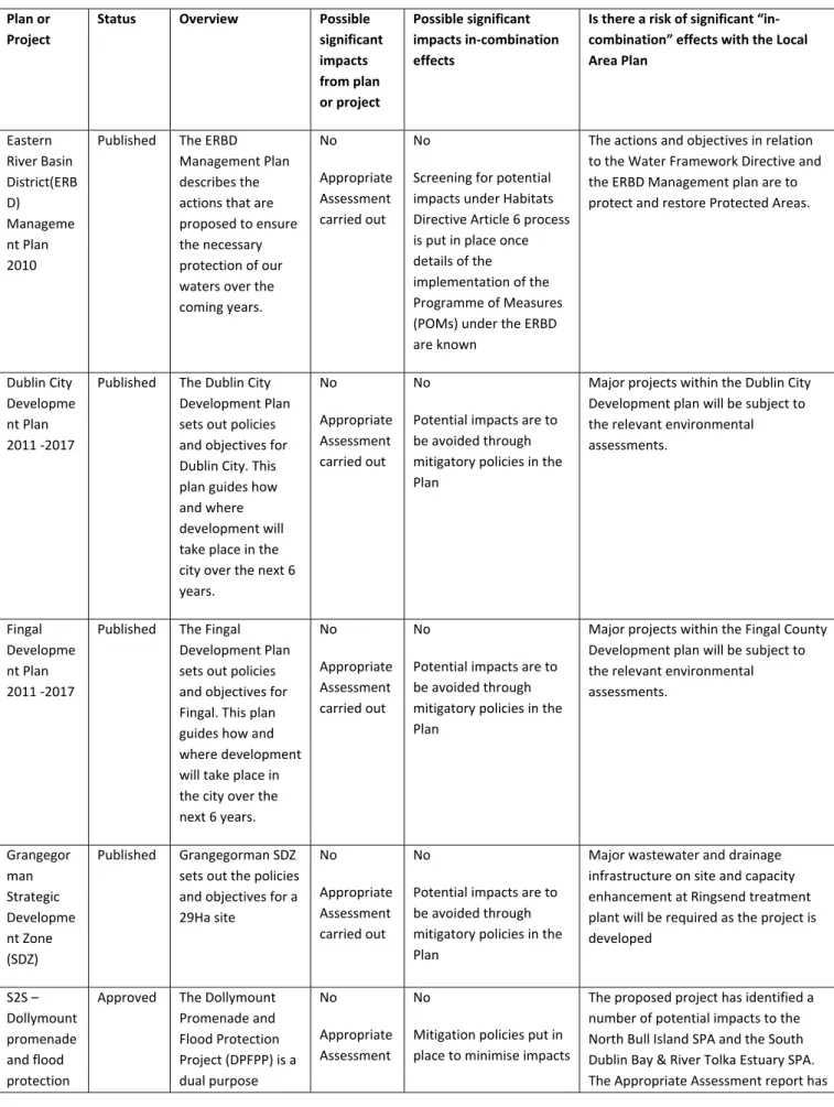
2.10 Other Developments nearby which could lead to cumulative impacts
Article 6(3) of the Habitats Directive requires that in combination or cumulative effects with other plans or projects are considered. The relevant plans and projects that have been reviewed with potential to result in in-combination effects with the Local Area Plan are as follows:
Eastern River Basin District Management Plan 2010
Dublin City Development Plan 2011-2017
Fingal Development Plan 2011 – 2017
Grangegorman Strategic Development Zone, 2012 (SDZ)
S2S Dollymount promenade and flood protection project, 2012
Dublin City Biodiversity Action Plan 2012-2016
The Dublin Waste to Energy facility
Rathoath Road re-alignment & Royal Canal Overbridge
Rail Station at Royal Canal Development
Luas Cross City
Ringsend Waste Water Treatment Plant, extension works
Table 2 - In-combination Effects - Major Relevant Plans and Projects in Vicinity of Ashtown/Pelletstown LAP
Plan or
Project
Status Overview Possible
significant impacts from plan or project Possible significant impacts in‐combination effects
Is there a risk of significant “in‐
combination” effects with the Local
Area Plan Eastern River Basin District(ERB D) Manageme nt Plan 2010
Published The ERBD
Management Plan
describes the
actions that are
proposed to ensure
the necessary
protection of our
waters over the
coming years. No Appropriate Assessment carried out No
Screening for potential
impacts under Habitats
Directive Article 6 process
is put in place once
details of the
implementation of the
Programme of Measures
(POMs) under the ERBD
are known
The actions and objectives in relation
to the Water Framework Directive and
the ERBD Management plan are to
protect and restore Protected Areas.
Dublin City
Developme nt Plan
2011 ‐2017
Published The Dublin City
Development Plan
sets out policies
and objectives for
Dublin City. This
plan guides how
and where
development will
take place in the
city over the next 6
years. No Appropriate Assessment carried out No
Potential impacts are to
be avoided through
mitigatory policies in the
Plan
Major projects within the Dublin City
Development plan will be subject to
the relevant environmental
assessments. Fingal Developme nt Plan 2011 ‐2017
Published The Fingal
Development Plan
sets out policies
and objectives for
Fingal. This plan
guides how and
where development
will take place in
the city over the
next 6 years. No Appropriate Assessment carried out No
Potential impacts are to
be avoided through
mitigatory policies in the
Plan
Major projects within the Fingal County
Development plan will be subject to
the relevant environmental
assessments. Grangegor man Strategic Developme nt Zone (SDZ) Published Grangegorman SDZ
sets out the policies
and objectives for a
29Ha site No Appropriate Assessment carried out No
Potential impacts are to
be avoided through
mitigatory policies in the
Plan
Major wastewater and drainage
infrastructure on site and capacity
enhancement at Ringsend treatment
plant will be required as the project is
developed S2S – Dollymount promenade and flood protection
Approved The Dollymount
Promenade and Flood Protection Project (DPFPP) is a dual purpose No Appropriate Assessment No
Mitigation policies put in
place to minimise impacts
The proposed project has identified a
number of potential impacts to the
North Bull Island SPA and the South
Dublin Bay & River Tolka Estuary SPA.
project scheme: 1. Provide promenade and cycleway connecting existing sections to complete 8km promenade and cycleway in North
Dublin Bay and
contribute to the overall aim of providing 22km in Dublin Bay. 2. Provide flood defence between
the Wooden Bridge
and Causeway Road
for residences along
Clontarf Road and
James Larkin Road.
carried out proposed a number of mitigation
measure in relation to the proposed
scheme and has concluded on the basis
of these that there will be no impact on
the integrity of the Natura 2000 sites.
Dublin City
Biodiversity
Action Plan
2011‐2016
Published The Biodiversity
Action Plan is in
place to aid with
the objectives of
the Dublin City
Development Plan relating to quality of life, greenspace and amenity provision, planning development, and the protection of natural heritage in the city.
No No The purpose of this plan is to aid
objectives of the Dublin City
Development Plan relating to the
protection of natural heritage in the
city. The plan will not have any adverse
impact on the Natura 2000 sites.
The Dublin
Waste to
Energy
Facility
project
Approved The Environmental
Protection Agency
have issued a
licence to DCC to
operate a non
hazardous waste to
energy facility. The
proposed Dublin
Waste to Energy
(DWtE) facility will
be located on the
Poolbeg Peninsula
in Dublin.
No No There are no significant impacts
envisaged on any of the Natura 2000
sites as a result of the DWtE facility.
Any impacts on water quality have the
potential to interfere with the key
relationships and structure of the SPA
as the majority of qualifying features
are aquatic ecosystem based. However,
during construction any discharge will
be in accordance with DCC
requirements and during operation the
cooling water will be discharged into
Dublin Bay in accordance with the EPA
Waste Licence (0232‐01) for the
facility. There is the potential for
terns nesting on the ‘Dolphin’ moorings
during the breeding season (May to
August) during the construction phase,
however mitigation will be put in place
to reduce this impact.
Rathoath Road re-alignment &Royal Canal Rail overbridge Pending (awaiting receipt of planning applicatio n as of April 2013) Provide greater connection via sustainable means
from the area to
the wider city and
region Relevant environmen tal assessment to be carried out No
Potential impacts are to
be avoided through
mitigatory policies in the
Plan
The purpose of the project is to provide
infrastructure that will aid objectives of
the Dublin City Development Plan
relating to the provision of sustainable
modes of transport. The project will
not have any adverse impact on the
Natura 2000 sites. Rail Station at Royal Canal developmen t Pending (awaiting receipt of planning applicatio n as of April 2013) Provide greater connection via sustainable means
from the area to
the wider city and
region Relevant environmen tal assessment to be carried out No
Potential impacts are to
be avoided through
mitigatory policies in the
Plan
The purpose of the project is to provide
infrastructure that will aid objectives of
the Dublin City Development Plan
relating to the provision of sustainable
modes of transport. The project will
not have any adverse impact on the
Natura 2000 sites.
Luas Cross
City Railwayorder
issued by RPA in 2012. Works scheduled to commenc e later in 2013. Provide greater connection via sustainable means
from the area to
the wider city and
region Relevant environmen tal assessment to be carried out No
Potential impacts are to
be avoided through
mitigatory policies in the
Plan
The purpose of the project is to provide
infrastructure that will aid objectives of
the Dublin City Development Plan
relating to the provision of sustainable
modes of transport. The project will
not have any adverse impact on the
Natura 2000 sites. Ringsend Waste Water Treatment Plant (WWTP) expansion works in line with implementa tion of the Greater Dublin Strategic Drainage Study (GDSDS) Ongoing works to extend capacity to equivalent populatio n of 2.1m by 2015 Ringsend WWTP expansion is part of the GDSDS project necessary to expand infrastructure in
line with population
growth No AA & SEA conducted No
The only possibility of a
negative impact would be
where the works are not
completed and there is
overloading of capacity.
The Ringsend WWTP will ensure the
population increase envisaged by the
LAP will have no detrimental impact
Royal Canal Greenway Plan (Fingal County Council Area) Planning applicatio n to be lodged in 2013 Outlines measures for the enhancement of
the canal from
Ashtown to Castleknock No AA and SEA carried out No
Potential impacts are to
be avoided through
mitigatory actions
The primary objective of the plan is to
provide a premium quality cyclist and
pedestrian route.
2.11 Stage One Screening – Conclusion
There are a number of Natura 2000 Sites (5) within Dublin Bay that have potential to be indirectly, significantly impacted upon due to the proposed LAP, as set out in Section 2.9. These are: North Dublin Bay SAC, South Dublin Bay SAC, North Bull Island SPA, South Dublin Bay/River Tolka Estuary SPA and Rockabill to Dalkey SAC. Potential threats to these Natura 2000 Sites include increased population, which is likely to result in increased recreational activity, potential construction impacts and potentially increased amounts of effluent which will be discharged into Dublin Bay via Ringsend WWTP. These threats have potential to result in a deterioration of water quality and disturbance to the qualifying interests of Natura 2000 Sites. These threats, in-combination with other plans and/or projects have potential to result in adverse impacts on Natura 2000 Sites and their qualifying interests. Accordingly, a Stage 2 Appropriate Assessment is required.
3.0
Stage Two: Appropriate Assessment
3.1 Assessment Methodology
The overall aim of the Habitats and Birds Directives is to maintain or restore the favourable conservation status of habitats and/or species of community interest. Site specific conservation objectives aim to define favourable conservation condition for particular habitats or species for that site. Further details on these sites are contained in Appendix 3. According to the European Commission interpretation document ‘Managing Natura 2000 sites: The provisions of Article 6 of the ‘Habitats’ Directive 92/43/EEC’, paragraph 4.6(3):
“The integrity of a site involves its ecological functions. The decision as to whether it is adversely affected should focus on and be limited to the site’s conservation objectives.”
Within this stage of the AA process often referred to as “Stage 2 of the Appropriate Assessment”, the potential impacts of the proposed development on the integrity of the surrounding Natura 2000 Sites are examined with respect to the conservation objectives of each European Site and to its general structure and function.
3.2 Natura 2000 Sites
Each Natura 2000 Site “screened in” during the Screening Stage was analysed in Section 2.9 with specific threats to each site discussed, including specific elements of the LAP
deemed to pose likely significant effects to the relevant Natura 2000 sites. In total 5 sites were “screened in” for potential adverse impacts:
North Bull Island SPA (IE004006)
South Dublin Bay & River Tolka Estuary SPA (IE004024)
North Dublin Bay SAC (IE00206)
South Dublin Bay SAC (IE00210)
Rockabill to Dalkey Islands SAC (IE003000)
3.3 Potential Impacts of the LAP on Natura 2000 Sites 3.3.1 Category of Impacts
1) Direct Impacts – refers to habitat loss or fragmentation arising from land-take requirements for development or agricultural purposes. Direct impacts can also be as a result of a change in land use or management e.g. removal of agricultural practices that prevent scrub encroachment.
2) Indirect and secondary impacts – which do not have a direct cause and effect relationship and are potentially more challenging to assess, ensuring that all the possible indirect impacts of the plan in combination with other plans and projects have been established. Deterioration in water quality for example can occur as an indirect consequence of development which in turn changes the aquatic environment and reduces its capacity to support certain plants and animals. The introduction of invasive species for example can also be defined as an indirect impact, which may result in the transfer of alien species from one area to another.
It is this category of indirect and secondary impact that will be most relevant to this particular assessment given that all the Natura 2000 areas are off-site and there could be ‘downstream’ effects related to construction impacts, transportation requirements or even omissions. Disturbance to fauna can arise directly through the loss of habitat (e.g. bat roosts) or indirectly through noise, vibration and increased activity associated with construction and operation of developments or other activities.
All Natura 2000 Sites and Qualifying Interests affected are listed below each relevant Indirect Impact.
3.3.2 Direct Impacts None
As indicated in earlier sections, there are no Natura 2000 sites within the LAP area. 3.3.3 Indirect Impacts
Population
The LAP provides a framework for sustainable planning and development of the study area and this would lead to increased population. The LAP will promote a more compact, consolidated, higher density city area to accommodate additional residential population,
encourage economic growth and development in Dublin City. However, as further discussed below, the City is at capacity / very close to capacity with regard to its wastewater infrastructure. As noted effluent, from the proposed LAP area will be received and treated by Ringsend WWTP with discharged into Dublin Bay. This may result in decreased water quality within Dublin Bay and the Natura 2000 sites it hosts which could potentially be significant and adverse. Potential threats from depreciation in water quality will be mitigated against with the Dublin City Development Plan’s policies to upgrade existing, and provide a new regional, wastewater treatment infrastructure which will be capable of supporting additional population and economic growth in the City. Furthermore, with increased population levels in the study area, potential for disturbance of species and/or erosion of habitat could result as more people seek to visit and / or take part in a wide range of land and water-based recreational activities on, or close to, the identified Natura 2000 Sites including North Dublin Bay SAC, South Dublin Bay SAC, North Bull Island SPA, South Dublin Bay & Tolka Valley Estuary SPA and Rockabill to Dalkey Island SAC.
Water Quality and Infrastructure Issues
Water Framework Directive (WFD) – Tolka River Overview
The Water Framework Directive (2000/60/EC) is a European Union (EU) directive which commits EU member states to achieve good qualitative and quantitative surface water status for their water bodies by 2015. To achieve ‘Good Surface Water Status, both the ecological status and the chemical status of a surface water body must be at least good. The LAP area is located within the Tolka Water Management Unit (WMU) in the Eastern River Basin District. A WMU is a geographic area primarily defined by similar hydrology and topography. The River Status in the Tolka Lower when it enters Dublin City is classified as ‘Poor’ and not favourable for fish or macroinvertebrates as determined by the Environmental Protection Agency (EPA) using hydrology, water quality, ecology and morphology monitoring data. The main problems identified in this WMU are high nutrients (phosphorous and ammonia) oxygen demand, low ecological rating, and a heavily modified channel. In the Tolka catchment the principle pressures in the upper catchments are from agriculture and wastewater and industrial discharge. In the lower catchment, i.e. when it enters Dublin City Council and Fingal, the principle pressures are combined sewer overflows (wastewater discharge) and foul sewers from houses and business misconnected to rivers. It may not be possible to achieve all core objectives by 2015, and in this water management unit, the main pressures preventing achievement of ‘Good Status’ by 2015 is diffuse agricultural and urban diffuse pollution and this could be exacerbated by any spillage from additional development in Ashtown/Pelletstown. For the Tolka catchment, the target is to achieve ‘good status’ by 2027. In relation to groundwater there is a continued need for improved protection of groundwater, especially in the context of achieving the WFD objectives of good status for all waters by 2015. Potential therefore exists for impacts upon Natura 2000 sites downstream of the River Tolka and River Liffey which discharge into Dublin Bay. A reduction in water quality has potential to impact upon the quality of the qualifying interest habitats contained within Dublin Bay and its Natura Sites, and their supporting fauna, upon which other qualifying interests such as wintering birds depend (qualifying interests of North Bull Island SPA and South Dublin Bay And River Tolka Valley Estuary SPA).
Ringsend Waste Water Treatment Plant
As previously highlighted above, Ringsend WWTP has limited resources for additional acceptance of effluent for treatment. In November 2012, Dublin City Council, received planning consent from An Bord Pleanala for the Ringsend Waste Water Treatment Works extension project (Anticipated completion date of 2015). The Plant will be extended to achieve the maximum capacity possible on the existing site. Its current capacity is 1.6 million population equivalent (P.E) and extension would aim to raise this by a further 500,000 to 2.1 million P.E. while still producing treated water of adequate standard. The Plant will use less energy, fewer chemicals, and produce less sludge to be treated and disposed. As a result, greenhouse gas emissions will be reduced. The outfall discharge will also be future-proofed in terms of sea level rise over the WWTP projected 100 year life.
There is a commitment under the Dublin City Development Plan 2011 – 2017 to which the LAP must be consistent to provide additional and improved wastewater treatment capacity by the upgrading of the Ringsend Waste Water Treatment Plant (Objective S145). The Ashtown/Pelletstown LAP includes a phasing programme which will ensure that development will only be carried out when the Water Services Authority is satisfied that capacity is available at the Ringsend Plant, and also due to the requirements of Trade Effluent Licences, in line with the upgraded operation of the wastewater treatment plant to ensure that the water quality of the Natura 2000 sites will not deteriorate as a result of LAP development. The implementation of the LAP, with its specific policies and objectives, for surface and foul waste water treatment, together with the proposed increased capacity of the Ringsend Treatment Plan by 2015 to cater for effluent discharge, is likely to improve the existing water quality entering Dublin Bay. Consequently the proposed upgrade and LAP policies will reduce potential threats to the Natura 2000 sites and their qualifying interests located within or off-shore of the Dublin Bay area.
Discharge and Overflow Arrangement
In relation to sewerage infrastructure there are a number of sewer overflows upstream of Ashtown/Pelletstown (one in Abbotstown and 3 near Mill Road, Blanchardstown) outside of the City Council’s administrative area which activate during periods of heavy rainfall. Their activation would have a temporary negative impact on water quality in the River. There are three surface water discharges from the Ashtown/Pelletstown development. The first is located a short distance downstream of Ashtown Bridge. The second is located midway along the development, discharging from the development via two sewers under River Road into an open channel in the new Cardiffsbridge Park. The third discharges near Rathoath Road. There is a pumping station on the foul network in the site of the development that has an overflow to the River Tolka. Floodwaters from the Royal Canal will be intercepted by the surface water drainage network within the development with a direct discharge to the open channel in Cardiffsbridge Park. (i.e. Bypassing the pumping station attenuation tanks). Such discharges and overflows, alone and/or in combination with other water quality threats discussed in this section, have potential to reduce water quality and negatively impact upon the qualifying interests and their supporting environmental conditions downstream.
Invasive Species
Invasive species including Japanese Knotweed Fallopia japonica, Giant Hogweed
Heracleum mantegazzianum and or Himalyan Balsam Impatiens Gladulifera have been recorded along the Tolka Valley and in areas of disturbed ground (DCC, 2010) Japanese Knotweed and Giant Hogweed Heracleum mantegazzianum are present along the Tolka River and in areas of disturbed ground (DCC, 2010).
Invasive species of plants should be controlled as recommended in the Management Guidelines Irish National Biodiversity Plan 2012 included in the LAP and supplemented with education programmes for the community. Exceptions may be made for certain non-native (but not invasive) species specifically known to be beneficial for wildlife such as high nectar plants and which are not listed on the Third Schedule of the Birds and Habitats Regulations 2011. Sites located downstream that have potential to be impacted upon include North Bull Island SPA, South Dublin Bay & River Tolka Estuary SPA, North Dublin Bay SAC and South Dublin Bay SAC.
Construction and Operational Impacts
During the construction phase of development there is potential for an increase in siltation and runoff which may contain polluting substances, which could enter the River Tolka and finally discharge into Dublin Bay. Best practice measures, appropriate mitigation measures and environmentally assured construction methods will ensure that there are no significant impacts on Natura 2000 Sites, this is particularly important as construction will likely be on a phased basis over an extended period of time. There is also the potential, for invasive species such as Japanese Knotweed to be spread downstream during onsite works, incidental infilling, gardening and other landscaping works.
Development works on undeveloped sites could impact on water quality during the construction and operational phases, which could have a potential adverse effect on the chemical water quality and biological water quality. Again uncontrolled or untreated surface water discharges and run-off including pollution incidents and non-attenuation of surface water drainage during construction could adversely impact on downstream Natura 2000 sites.
As previously described there is an ongoing upgrade of Ringsend Waste Water Treatment Plant to raise the operational capacity from 1.6m population equivalent to 2.1m population equivalent. The completion date for these upgrade works are 2015. The LAP area is also adjoining the Maynooth rail line, and occupies a strategic location on a gateway point into the city, providing good public transportation links to the wider metropolitan areas including Dublin City Centre and Dublin Airport. There will also be an expansion of Green Infrastructure routes through the area, including cycling routes. Both transport initiatives increase the number of patrons/visitors in the area. Disturbance impacts from increased visitors to the area combined with potential water quality issues have potential to result in adverse impacts on the integrity of Natura 2000 sites downstream including North Dublin Bay SAC, South Dublin Bay SAC, North Bull Island SPA, South Dublin Bay & Tolka Valley Estuary SPA and Rockabill to Dalkey Islands SAC.
Indirect Impact Summary
In summary the main potentially significant indirect impacts of the Ashtown/Pelletstown LAP on surrounding Natura 2000 Sites, include:
1) Possible impacts during the construction and operational phases of developments, which could have potential adverse effects on water quality (e.g. release of silt and/or pollutants). 2) Impact of Infrastructural Deficiencies e.g. incapacity of municipal wastewater
infrastructure to cater for additional load.
3) Spread of invasive species during construction and operation phases.
4) Increase in population and infrastructural links may result in increased recreational pressures, including disturbance and on coastal and marine Natura 2000 Sites.
The Ashtown/Pelletstown LAP has taken these potential impacts into consideration during the development of the LAP and design of policies and objectives. To ensure the protection of Natura 2000 Sites and avoidance of significant impacts, mitigatory policies were devised and included within the LAP.
Cumulative Impacts
Having regard to Section 2.10, it is considered that, with mitigation in place, significant in-combination or cumulative effects on Natura 2000 sites are considered unlikely, in relation to the Local Area Plan.
3.4 Implementation of Mitigation Policies and Objectives
The screening process undertaken in Stage 1 includes the determination of whether or not each objective has a potential impact on the integrity of the Natura 2000 Sites, and the reasons for this determination. The majority of objectives were deemed not to have an impact or were themselves of a mitigatory nature. As noted, protective, mitigatory measures were devised and included within the LAP. Together with the mitigatory policies of the Dublin City Development Plan 2011-2017, (Section 1.6), these protective objectives in the Local Area Plan will be used to avoid or reduce the potential for significant impacts on the integrity of identified Natura 2000 sites.
The responsibility for implementing the LAP lies with the Planning Authority through the Planning consent process. Applicants who intend to develop within the LAP area are obliged to ensure that their application is consistent with the objectives of the LAP. If it cannot be shown conclusively that the criteria outlined in the mitigation objective can be met, planning permission will not be granted.