Design of Soil Moisture Sensor for Validation of
Passive Microwave Remote Sensed Soil Moisture Data
Muktimani Brahma
1, Bikramjit Goswami
2, Manoranjan Kalita
3 1Don Bosco College of Engineering and Technology, Assam Don Bosco UniversityAirport Road, Azara, Guwahati - 781017, Assam. INDIA. [email protected]
2
Don Bosco College of Engineering and Technology, Assam Don Bosco University
Airport Road, Azara, Guwahati-781017,Assam,INDIA. [email protected] 3
Don Bosco College of Engineering and Technology, Assam Don Bosco University
Airport Road, Azara, Guwahati-781017, Assam, INDIA. [email protected]
Abstract: Soil Moisture is an important parameter that is of immense importance in the field of civil engineering,
agriculture and ecology. Development of weather patterns and intake of nutrient by plants depend on soil moisture. In this paper, the design of sensor is described that uses the electrical resistance attribute of soil moisture. The soil moisture product of Advanced Microwave Scanning Radiometer-2 on board GCOM satellite of Japan Aerospace Exploration Agency (JAXA) is then compared with the soil moisture obtained from the designed sensor. Analysis shows the variability of the soil moisture values measured by both the satellite as well as the actual soil moisture measured by gravimetric method for the samples collected from different locations. The designed sensor shows similar variations in its output. Hence, the designed sensor can be used for checking the variations happening in soil moisture values instantaneously and can be used to validate the soil moisture product of remote sensing satellites for different locations.
Keywords: Soil Moisture, Resistive Sensor, AMSR-2, Passive Microwave Remote Sensor.
1.
Introduction
Soil Moisture is the water present in the soil. It can be measured as: a) Volumetric water content: Ratio of volume of water to the total volume of wet solid soil material. b) Gravimetric water content: Ratio of mass of water to mass of substance. The permittivity of the soil is dependent on water present in the soil. Different soil types have different moisture retention capacities. The retention capacity is found to be highest for clay soil. Soil moisture plays a vital role in the field of engineering, agriculture, ecology and meteorology. It is important for plant’s growth as the intake of nutrients is done by water present in the soil. In civil engineering, the study of soil compaction determines its strength for erecting structures on it. Poor compacted soils will cause structural damage. The soil moisture is also important for predicting weather in the field of meteorology. Soil moisture can be measured using various electrical techniques. One such technique is the electrical resistance technique which uses the electrical properties of the soil to measure the moisture content in the soil. This technique operates on the principle that resistance between two electrodes intruded in the soil will change with the moisture content of the soil.
J. A. Munoz and others [2] used the electrical resistivity probe for measuring the resistivity of soil with variation in moisture. The volumetric water content increased from 5.8% to 38.5% with decrease in resistivity from 338Ωm to 8Ωm. For dry soil, the resistivity reached values higher than 50Ωm. At lowest degrees of saturation the resistivity is found to be highest and for higher degrees the resistivity is lowest.
Sudhir et al. [3] determined the water content in the sand. The oven dried sand and bore well water was used for preparing the sample. The test mould is cylindrical and the ends are pressed with copper plates which behave as the outer electrodes. Two other copper rods were placed inside the specimen with spacing of 0.0424m. DC voltage ranging from 0 to 30V is applied to the outer plates and the resistivity is measured. At low water content of 1.02% the resistivity is undetermined. For 30V DC supply electrical resistivity value varied between 49.723–297.666 ohm-m. The analysis showed that the electrical resistivity increases with decrease in moisture content.
W. John McCarter [4] found the electrical resistivity characteristics for compacted clays. The sample was compressed into a conductivity cell. The electrical resistance is measured by Terrameter. After testing,
the clay is remixed and compacted to ensure the moisture remain constant. At saturation the moisture content remained constant. The resistivity dropped as the volumetric water content is reduced to zero and increasing the same showed change in resistivity. Similarly, it has been observed that increasing the degree of saturation also decreases the resistivity. Resistivity is thus a function of moisture content and degree of saturation.
Passive microwave remote sensing uses microwave radiation from earth’s surface for observing the earth surface parameters. Because of longer wavelength microwave can penetrate through cloud, rain, dust. A passive microwave remote sensor has a receiving antenna that receives signals at microwave frequencies emitted from objects on the earth’s surface. The received signal is the microwave energy emitted by the objects which, is related to temperature and moisture of the object. Passive microwave remote sensing is used in oceanography, hydrology and meteorology. It is used in measurement of soil moisture as microwave emission is influenced by moisture content. At microwave frequencies the brightness temperature and radiances are proportional to the amount of moisture in soil.
2.
Design of Soil Moisture Sensor
Figure 1 below shows the design of the soil moisture sensor. The sensor is made using two aluminum probes of 10cm length, 1cm breadth each. The probes are separated from each other using plastic material and placed 1.5cm apart. The sensor operates on the principle of electrical resistance technique where the resistance between the probes will change with variation in the soil moisture [5].
Figure1: Soil Moisture Sensor Design.
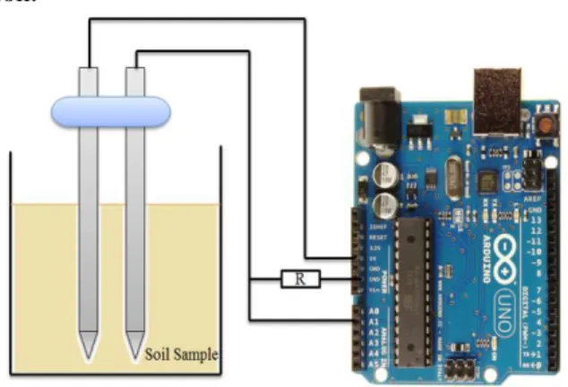
The circuit diagram of microcontroller based sensor circuit diagram for soil moisture measurement is shown in figure 2. The output from the sensor is connected to the analog pin of arduino. The analog output values are recorded using serial input in its analog input pin for different moisture values of the soil.
Figure 2: Circuit diagram of microcontroller based sensor for soil moisture measurement.
3.
Calibration of Soil Moisture Sensor
Soil samples from different sources are collected on different dates for calibration of the designed soil moisture sensor. The gravimetric method is used for determining the moisture content of the soil. In this method the soil samples are oven dried at 105ºC. The weights before drying and after drying are recorded. The moisture content percentage then is calculated by using the formula below:
(1) The sensor output corresponding to different soil moisture values for various soil types from different sources is shown in the Table 1. The soil moisture is measured for the sample as collected. Also by adding various amount of water, the moisture is increased in the sample and the sensor output values are recorded against the measured soil moisture levels using gravimetric method. Figure 3 shows the variations of microcontroller’s output against soil moisture values for different soil types from various sources. It is seen that for different soil types the sensor output shows variations with changes in soil moisture values. This way the sensor is calibrated for measuring soil moisture of a particular place.
TABLE 1:SENSOR OUTPUT VALUES CORRESPONDING TO VARYING SOIL MOISTURE VALUES Soil sample source Date Soil Moisture (%) Sensor output (Resist ance) Micro-controller output Soil sample from Azara (26.10 03ºN 91.612 9ºE) 28/09/16 13.77 533 KΩ 3 15.98 134 KΩ 47 25.60 79 KΩ 192 29.87 60 KΩ 231 Tea Garde n soil sample from Kokraj har (26.23 55ºN 90.145 9ºE) 15/10/16 16.90 820 KΩ 5 17.88 724 KΩ 69 20.62 160 KΩ 198 36.98 147 KΩ 270 Riversi de sandy soil from Kokraj har (26.51 36ºN 90.224 5ºE) 15/10/16 4.18 1150K Ω 2 20.07 140 KΩ 38 24.26 51 KΩ 67 26 27 KΩ 137
Figure3: Arduino Serial Monitor value Vs. Soil Moisture.
Figure4: Arduino Serial Monitor value Vs. Soil Moisture.
Figure5: Arduino Serial Monitor value Vs. Soil Moisture.
4.
Source of Remote Sensing Data
Validated
Advanced Microwave Scanning Radiometer-2 (AMSR-2) is a remote sensor used for measuring the microwave emission from earth’s surface. AMSR-2 can see through clouds thus an uninterrupted view of moisture measurement is obtained. The GCOM-W1 satellite carries in the AMSR-2 radiometer to obtain the weak microwave signals. The satellite rotates once in every 2 days. The data for day and night are recorded and can be downloaded freely.
The soil moisture data available on the website of Global Change Observation Mission (GCOM) under Japan Aerospace Exploration Agency (JAXA) are downloaded and used for validation with the measured soil moisture data obtained using the gravimetric method. The satellite passes the same area after every 16 days so the soil moisture data for the same area cannot be obtained every day [6]. However value for certain area can be estimated by the average of the nearby pixels so obtained from the
0 50 100 150 200 250 300 350 400 450 500 0 10 20 30 40 Ar d u in o se ria l m o n ito r v a lu e Soil Moisture(%)
soil sample from tea garden 0 50 100 150 200 250 300 350 400 450 500 0 10 20 30 40 Ar d u in o se ria l m o n ito r v a lu e Soil Moisture(%)
Soil sample from azara
0 50 100 150 200 250 300 350 400 450 500 0 10 20 30 Ar d u in o se ria l m o n ito r v a lu e Soil Moisture(%)
data. The soil moisture data are stored in hierarchical data format (HDF) in the Satellite.
The soil moisture product used has a resolution of 10 km X 10 km. So, within a pixel the soil moisture value that is derived based on brightness temperature is affected by the open water bodies largely.
5.
Validation of Soil Moisture Sensor
data of AMSR-2 for two different
places
The soil moisture data for different dates are downloaded and the satellite measured soil moisture values are compared with the soil moisture measured using gravimetric method. The comparison results are shown in table 2. Here, the measured and satellite derived soil moisture values are almost matching for some places, but show differences in some other places. This happens primarily due to the variations in land cover types. Especially in case of places having large open water bodies, the satellite derived soil moisture values are not accurate. Hence it is necessary to know about the actual and satellite measured soil moisture values, whether they are same or different for a particular place. This can be known only by in-situ measurement.
However the techniques such as gravimetric method of soil measurement are time consuming, as there is a requirement of soil drying for 24 hours in those cases. Moreover, in case of commercially available soil moisture sensors, the sensitivity is very less. Therefore there is a requirement of developing instantaneous soil moisture measurement methods using more sensitive sensors. The present resistive sensor described in this paper is the result of such an attempt.
The validation of the soil moisture product of AMSR-2 shows the suitability of the product for Azara area and the corrections required in the soil moisture values for Kokrajhar.
TABLE 2:VALIDATION OF SOIL MOISTURE DATA Soil Sample Source Co-ordinates (latitude/ longitude ) Date of Sample Collection Measured Soil moisture (%) Satellite measured soil moisture (%) Soil Sample from Azara 26.1003ºN 91.6129ºE 28/09/16 13.77 12.80 Tea Garden Soil Sample from Kokrajhar 26.2355ºN 90.1459ºE 15/10/16 16.90 12.83 Riverside Sandy Soil from Kokrajhar 26.5136ºN 90.2245ºE 15/10/16 4.18 9.60
6.
Conclusion
Soil moisture measuring resistive sensor system is designed using microcontroller based serial monitoring facility. The sensor is then calibrated with the measured soil moisture values using gravimetric method. The soil moisture product of AMSR-2 is then validated with the in-situ measured values. The measured soil moisture values by both gravimetric technique and by AMSR-2 show similarities in some places and variations in some other. Thus the need of validation of satellite derived soil moisture data for various places instantaneously is met with the designed soil moisture sensor. Thus the sensor can be used for checking the variations happening in soil moisture values and can be used to validate the soil moisture product for different places, especially in the regions like the state of Assam, India, where there are a lot of land cover type changes within a small geographic area.
References
[1] Johnson, Arnold Ivan. Methods of measuring
soil moisture in the field. US Government Printing Office, 1962.
[2] Muñoz-Castelblanco, J. A., Pereira, J. M., Delage, P., and Cui, Y. J., "The Influence of Changes in Water Content on the Electrical
Resistivity of a Natural Unsaturated Loess," Geotechnical Testing Journal, Vol. 35, No. 1, 2012, pp. 1-7.
[3] Bhatt, Sudhir, and Pradeep K. Jain. "Correlation
between electrical resistivity and water content
of sand–a statistical approach." American
International Journal of Research in Science,
Technology, Engineering & Mathematics
(2014): 115-121.
[4] McCarter, W. J. "The electrical resistivity
characteristics of compacted
clays." Geotechnique 34.2 (1984): 263-267.
[5] Johnson, Peter Morris St Clair. The design of an
integrated soil moisture sensor for agriculture. Diss. Griffith University, 2007.
[6] Beitsch, Alexander, Lars Kaleschke, and Stefan
Kern. "Investigating high-resolution AMSR2 sea ice concentrations during the February 2013 fracture event in the Beaufort Sea." Remote Sensing 6.5 (2014): 3841-3856.
Author Profile
Muktimani Brahma, is pursuing M Tech in Assam Don Bosco University, India. She received her B Tech degree in Instrumentation Engineering from Central Institute of Technology (India) in 2014. Her area of interest includes Embedded system, Microwave Remote Sensing and Measurement Systems.
Bikramjit Goswami, is pursuing Ph.D. in Assam
Don Bosco University, India. He is working as Assistant Professor in Assam Don Bosco University, Guwahati, India. He received his M Tech degree in Electronics and Communication Engineering from Gauhati University (India). His research interests
include Microwave Remote Sensing,
Electromagnetism and Power Systems. He has published more than 10 papers in international journals and presented papers in more than 15 national as well as international conferences till date. His present research area is flood detection and early warning in the state of Assam, India.
Manoranjan Kalita, is the Director of School of
Technology, Assam Don Bosco University, India. He
received his master degree in Civil Engineering from
University of Roorkee (India) in 1993, Ph.D. in Civil Engineering from IIT Delhi (India) and PGDHRM from Gauhati University (India). He received University Medal for securing 1st position in 1st Class in M.E, University of Roorkee, 1993. His research areas include Geoinformatics, Microwave
Remote Sensing, Water Resources and
Environmental Engineering and Transportation
Engineering. He has published papers on Remote Sensing in National and International Journals.