Collaborative BIM-based Markerless Mixed Reality Framework for Facilities Maintenance
Khaled El Ammari1and Amin Hammad2
1
Department of Building, Civil and Environmental Engineering (BCEE), Concordia University, 1455 de Maisonneuve Blvd. W., Montreal, Quebec, Canada H3G 1M8 Tel: (514) 848-2424 ext: 7074; email: [email protected]
2
Concordia Institute for Information Systems Engineering (CIISE), Concordia University. 1515 Ste-Catherine Street West, Montreal, Quebec, H3G 2W1
Tel: (514) 848-2424 ext: 5800; email: [email protected] ABSTRACT
Facilities maintenance tasks require gathering and sharing large amount of information related to facilities components. This information covers historical inspection data and operation information. Despite the availability of sophisticated Computerized Maintenance Management Systems (CMMSs), these systems focus on the data management aspects (i.e. work orders, resource management and asset inventory) and lack the functions required to facilitate data collection and data entry, as well as data retrieval and visualization when and where needed. Building Information Modeling (BIM) provides opportunities to improve the efficiency of CMMSs by sharing building information between different applications/users throughout the lifecycle of the facility. This paper proposes a framework for a collaborative BIM-based Markerless Mixed Reality (BIM3R). The framework integrates CMMS, BIM, and video-based tracking in a BIM3R setting to retrieve information based on time (e.g. inspection schedule) and the location of the user, visualize maintenance operations, and support collaboration between the field and the office to enhance decision making. Finally, a prototype system is implemented and a case study is applied to demonstrate the feasibility of the proposed approach.
INTRODUCTION
The Facility Management (FM) domain is a fragmented domain which needs a lot of coordination between parties. There are several methods that can be used to model the information of operation and maintenance processes and to monitor the execution progress of these processes. Among these methods, Building Information Modeling (BIM), video recording, and location tracking of construction resources have been extensively studied in recent Augmented Reality (AR) research (Chae and Kano 2007). The Computerized Maintenance Management System (CMMS) requires inspectors to accurately find and record defects during an inspection task. However, conventional systems have limited support for spatial visualization. Additionally, the re-entry of the data at the office results in input errors and lower efficiency. Consequently, facility inspection evaluation results may vary depending on the
accuracy of inspection data input and the inspectors’ expertise. In order to overcome these difficulties, this paper is directed to develop an accurate, practical, and generic collaborative BIM-based system to facilitate real-time and on-site data collection and to support inspectors in evaluating building elements using Mixed Reality (MR) as visualization technique. In addition, the paper discusses the MR components and taxonomy for AEC/FM. At last, a prototype system is implemented and a case study is applied to demonstrate the feasibility of the proposed method.
BIM in facilities management. Facility managers are responsible of maintaining the functions of the facilities by integrating people, place, process and technology, which can be done using BIM technology (NBIMS 2012). The main goal of using BIM is to increase communication and collaboration between stakeholders through data interoperability during the facility’s lifecycle. Although there are some open BIM formats claiming to meet BIM requirements, Industry Foundation Classes (IFC) is considered as the most used interoperability format in the AEC/FM industry (Mitchell and Schevers 2006). However, some tools which meet some of the BIM definitions, but do not support IFC, are still considered as BIM-compatible tools by some studies. Becerik-Gerber et al. (2012) conducted interviews with FM personnel to identify the role of BIM in FM. Their results show that most of current FM functions are done manually and that using BIM in FM can decrease the chances of errors and increase efficiency. Additionally, IFC Extensible Markup Language (ifcXML) is one of the most effective formats to transfer data to CMMS (NBIMS 2012).
Mixed Reality (MR). According to Milgram’s MR continuum diagram (Milgram et al. 1994), there are several levels of augmentation: (a) Augmented Reality (AR); (b) Augmented Virtuality (AV); and Virtual Reality (VR). The MR integrates a real-time view of the user’s environment and virtual objects within the same environment. Augmenting the real view with virtual objects is called AR mode, while augmenting the virtual 3D scene with part of the real view is called AV mode. In both modes, extra textual information or 2D/3D objects can be superimposed on the scene. AR can extend the perception capabilities of the user in the real world and improve the interaction capability with the augmented objects, providing information that the user cannot detect personally and directly (Izkara et al. 2007). AR has been used in construction for supporting building inspection (Koch et al. 2012), for visualizing construction equipment operations (e.g., Behzadan et al. 2008), for supporting the interaction of two users operating two virtual cranes and communicating with each other (Hammad et al. 2009), and for automatic construction progress monitoring (Golparvar-Fard et al. 2009). In addition, Gjosater (2012) presented a taxonomy of Handheld AR (HAR) applications. Normand et al. (2012) presented a typology of AR applications based on the tracking requirements. Zhou et al. (2008) presented five main research areas in AR: (1) tracking techniques, (2) interaction techniques, (3) calibration and registration, (4) AR applications, and (5) display techniques. Each of these areas has requirements and the most challenging part is the calibration and registration, which can be expensive due to the lack of automated calibration methods.
Tracking taxonomy for MR. Several technologies have been investigated for location tracking including the Global Positioning System (GPS) (Riaz et al. 2006), Radio Frequency Identification (RFID) (Chae and Yoshida 2008), and Ultra-Wideband (UWB) Real Time Location Systems (RTLS) (Cho et al. 2010). The existing tools for Computer Vision (CV) based tracking offer the capability for using single camera or multiple cameras to have better location tracking. This allows MR application’s users to use feature tracking based on multiple views (Cote et. al 2013). The CV-based tracking methods can be either marker-based tracking, using a predefined physical marker, or markerless-based tracking using natural features. In markerless tracking, the detection of localized features from the natural environment can be done using the Scale Invariant Feature Transformation (SIFT) to estimate the camera pose for localization and tracking (Yuan 2006). The markerless methods can provide useful information about the FM processes and have certain advantages and disadvantages. For example, video monitoring provides a rich visual source of information that can be used by a human observer or can be automatically processed to extract features using video processing techniques (Chae and Kano 2007). However, processing the video contents is complex and has several limitations (Sridhar and Kamat 2011) and does not identify FM resources (workers, equipment and materials) captured in the video. RTLSs, on the other hand, can identify them and also their exact locations.
PROPOSED METHOD
Mixed reality components for AEC/FM. Based on the taxonomies discussed in Section 1, MR has been used in AEC/FM in mobile and stationary modes, as well as indoor and outdoor scenarios. All these scenarios require better understanding of the MR requirements. Figure 1 illustrates the MR components (MR contents, tracking, and input and control devices) which are required to satisfy the needs of the MR applications in AEC/FM. To satisfy the human senses, there are some technologies that can be used in MR applications to enhance the usability of the system. For example, smell detection sensors (e.g. e-nose) can be used to alert the BIM-based Markerless Mixed Reality (BIM3R) user about any chemical hazards that a human cannot smell. Furthermore, there are other technologies for user feedback (e.g. haptic data glove) which can be used to enhance the interaction experience. Schall et al. (2008) introduced the virtual excavation concept to allow differentiation between the real world and the AR virtual objects.
In MR applications used in indoor scenarios, contextual information about the actual work performed cannot be provided using only RTLS tracking devices and MR contents (e.g. BIM). Therefore, computer vision can be used separately or combined with RTLS to improve tracking and to provide the contextual information. It can be integrated with BIM and be used to provide better understanding of the building element conditions within AV or AR environments. However, feature-based tracking accuracy depends on many factors such as good features, light conditions, and other image processing related issues (e.g., the resolution of the camera).
Inspection task process. In BIM3R, the detection and marking of a defected building element, as shown in Figure 2, starts with the inspector walking around the facility for routine or scheduled inspection. After the inspector locates a defect, the defected
Classification MR Components MR RFID GPS UWB WIFI Location Accelerometer Gyroscope Motion / Rotation Microphone
Sound objects Audio
Camera Kinect CV Marker-based Markerless Touch screen Keyboard Mouse Joysticks Input Device AR Gloves 3D Models (BIM) 4D Models (SIM) Virtual Objects
2D objects (CAD, GIS)
Desktop / Laptop PC
Handheld Device
Head Mounted Display
Optical see-through Video See-through Sight Hearing Touch Smell Feedback Gloves Vibration 2D 3D Single camera output
Multi camera output Video
Smell detection sensors e-nose (Arshak et al. 2003)
F o r s a f e t y w a r n i n g i n F M MR contents Tracking
Category Visualization and feedback devices
Input Output
Figure 1. Taxonomy for MR components for AEC/FM
element is located and its ID is shown within the AR scene. In the second step, the inspector will be able to either mark the defected element or retrieve recorded inspection information. If the inspector chose to mark the defected element, the defect location information will be automatically inherited from the BIM model and added as attributes.
Navigate Locate defect Locate element ID
Save defect data Add defect
attributes Mark the defect Update
database Check maintenance
schedule Retrieve previous inspection data More defects? No Yes Share with FM Office Start End New defect? Yes No Mobile AR mode
Office VR/AV modes
Need an action?
No
Yes
Issue work order
Figure 2 Flowchart of detection and marking defects in BIM3R
Then, the inspector is asked to add other defect related attributes which are: (1) type of the defect, (2) severity of the defect, (3) excepted consequences, and (4) any other notes or observations. All these data will be saved in XML-based database and instantly shared with the FM office using an AV mode, for planning and consultation.
IMPLEMENTATION AND CASE STUDY
The BIM3R structure has two sides: (1) the inspector side, which is implemented in AR mode and (2) the FM office side, which can be in VR or AV
mode. The facility manager can update the inspector through the database or directly using the text messaging feature of the system. He also can monitor or consult with the inspector by sharing the inspector view. BIM3R is developed using Autodesk Revit 2013 for BIM modeling, Unity3D 4.2 for system development, and D’Fusion Studio v 3.26 for creating markerless tracking scenarios. D’FusionForUnity plugin allows the system to read the tracking scenarios and detect features.
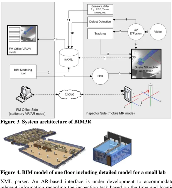
System architecture of BIM3R. Figure 3 shows the system architecture which consists of three major parts: (a) mobile inspector part; (b) FM office part; and (d) cloud part. The integration process is explained as the following steps: (1) A BIM-based modeling tool (e.g., Autodesk Revit) is used to create the 3D BIM model. This model is converted to FBX format. This format is supported by Unity3D Engine and it keeps sufficient building information for the purpose of visualization and for data retrieval later on; (2) the same BIM model is saved as ifcXML file. This file is considered as a database used to facilitate the data entry for the FM inspection tasks. This requires using an XML parser to write and retrieve data at the data interaction stage; (3) The ASCII FBX is imported into Unity3D as an asset file; (4) the two-way interaction relationship between the FBX file within the user mobile application and the ifcXML model located on the server side is necessary to update the scene with any added information collected by sensors or captured by the camera. These data could be a defect or any piece of information that can help the FM inspector/manger to perform the inspection tasks; (5) Video streaming data (frames) are processed using computer vision (CV) and scenario manager tools within D’Fusion studio to create the tracking scenarios; (6) This feature-based tracking scenarios are created as XML files and used within Unity3D to locate the mobile system user; (7) Using D’FusionForUnity plugin or OpenCV allow the system to recognize features from the video. This allows reading the tracking scenarios created in the previous step; (8) the exported tracking scenarios are used to keep track of the camera location and orientation; (9) Edge detection feature in OpenCV can be used to compare building component’s deformation (e.g., buckling) or to detect cracks; (10) Following the steps illustrated in Figure 2, detected cracks information is added to the database using XML parser. This step should consider the ifcXML schema to ensure future interoperability; (11) Data collected from different types of sensors can help the inspector evaluate the conditions of the facility. These collected data will be saved in the database and instantly used to augment in the building model; and (12) the inspector might share the updated scene (AR or AV mode) with the FM office for consultation and decision-making purposes.
Case study. A case study is applied at Concordia University to demonstrate the feasibility of the proposed method. A BIM model is created for one floor of the engineering building using Autodesk Revit (Figure 4). This model includes a detailed model (LoD 400) of a research lab located on the same floor. Based on the inspection scenario, any component’s damage is added as a subcomponent of that component. Therefore, there is a need to present formal definitions of the defects in the BIM modeling process.
The facility data which are coming from different sources are integrated and stored using ifcXML2x3 standard format, which makes it searchable through an
Figure 3. System architecture of BIM3R
Figure 4. BIM model of one floor including detailed model for a small lab
XML parser. An AR-based interface is under development to accommodate the relevant information regarding the inspection task based on the time and location of the inspector. In addition, The AR mode of the system is used to visualize 3D building components which are coming from the FBX model and their inspection information from the database.
Figure 5 shows the results of the created tracking scenarios, where the system is able to keep track of the user location based on the detected features and augment the relevant information based on his current location.
Figure 5. Screenshots of the tracking results
Augmentation: Edges of HVAC unit Augmentation:
CONCLUSIONS AND FUTURE WORK
The conclusions are: (1) A new method has been discussed based on combining data from BIM, video, sensors, and RTLS in order to better facilitate inspection operations; (2) A taxonomy for MR components for AEC/FM has been presented; and (3) A prototype system is under development and a case study is applied to demonstrate the feasibility of the proposed method. The future work includes: (1) Testing the system for indoor and outdoor scenarios; and (2) Enhancing the interaction methods of the system considering the physics engine; (3) Implementing multi-camera based tracking scenario.
ACKNOWLEDGEMENTS
We would like to express our gratitude to Ameen Albahri, who assisted in developing the BIM model and Daniel Gauthier from the FM Department of Concordia University for providing us with the related data.
REFERENCES
Arshak, K. Lyons, G.M. Cunniffe, C. Harris, J. Clifford, S. (2003). “A review of digital data acquisition hardware and software for a portable electronic nose.” Sensor Review Volume: 23 Issue: 4.
Becerik-Gerber, B., Jazizadeh, F., Li, N., and Calis, G. (2012). ”Application Areas and Data Requirements for BIM-Enabled Facilities Management.” Journal of Construction Engineering and Management. Volume 138, Issue 3
Behzadan, A.H., Timm, B.W. and Kamat, V.R. (2008). “General-purpose modular hardware and software framework for mobile outdoor augmented reality applications in engineering.” Advanced Eng. Informatics, Vol. 22, pp. 90-105. Chae, S. And Kano, N. (2007). “Application of location information by stereo camera images to project progress monitoring.” Proceedings of the 24th International Symposium on Automation & Robotics in Construction, ISARC, pp. 89-92. Chae, S. and Yoshida, T. (2008). “A study of safety management using working area
information on construction site.” Proceedings of the 25th International Symposium on Automation and Robotics in Construction, Vilnius, Lithuania, pp. 292-299.
Cho, Y.K., Youn, J.H. and Martinez, D. (2010). “Error modeling for an untethered ultra-wideband system for construction indoor asset tracking.” Automation in Construction, Vol. 19, pp. 43-54.
Cote, S., Barnard, J., Snyder, R., and Gervais, R. (2013). “Offline spatial panoramic video augmentation for visual communication in the AEC industry.” Proceedings of the 13th International Conference on Construction Applications of Virtual Reality, London.
Gjosater, T. (2012). “A taxonomy of handheld augmented reality applications.” 4th International Conference on Intelligent Human Computer Interaction (IHCI). Golparvar-Fard, M., Pena-Mora, F., and Savarese, S. (2009). “D4AR- a
monitoring data collection, processing and communication.” Journal of information technology in construction, Vol. 14, pp. 129-153.
Hammad, A., Wang, H., and Mudur, S.P. (2009). “Distributed augmented reality for visualizing collaborative construction tasks.” Journal of computing in civil engineering. Vol. 23, No. 6, pp. 418-427.
Izkara, J.L., Perez, J., Basogain, X., and Borro, D. (2007). “Mobile augmented reality, and advanced tool for the construction sector.” Proceedings of the CIB 24th W78 Conference, Bringing ICT Knowledge to Work, Maribor, Slovenia, pp. 453-460.
Koch, C., Neges, M., Konig, M., and Abramovici, M. (2012). “BIM-based Augmented Reality for Facility Maintenance using Natural Markers.” Proceedings of the 19th International Workshop on Intelligent Computing in Engineering, Munich.
Milgram, P., Takemura, H., Utsumi, A., and Kishino, F. (1994). "Augmented reality: a class of displays on the reality-virtuality continuum." SPIE Vol. 2351, Telemanipulator and Telepresence Technologies
Mitchell, J., and Schevers, H. (2006). “Building Information Modeling for FM using IFC.” CRC Construction Innovation. <http://www.construction-innovation.info/indexea25.html > (Oct. 10, 2013).
NBIMS (2012). “The National BIM Standard-United States. Version 2: Overview, principles and methodologies.” National Institute of Building Sciences. <http://www.nationalbimstandard.org > (Oct. 10, 2013).
Normand, J., Servieres, M., and Moreau, G. (2012). “Typology of augmented reality applications based on their tracking requirements.” Location Awareness for Mixed and Dual Reality. LAMDa workshop. Lisbon, Portugal.
Riaz, Z., Edwards, D.J., and Thorpe, A. (2006). “Sightsafety: A hybrid information and communication technology system for reducing vehicle/pedestrian collisions.” Automation in Construction, Vol. 15, pp. 719-728.
Schall, G., Mendez, E., Kruijff, E., Veas, E., Junghanns, S., Reitinger, B., and Schmalstieg, D. (2008). "Handheld Augmented Reality for Underground Infrastructure Visualization." In Personal and Ubiquitous Computing, Special Issue on Mobile Spatial Interaction, Springer. Volume 13, Issue 4, pp 281-291 Sridhar, S. and Kamat, V. (2011). “A Real-time markerless camera pose estimation system for augmented reality.” Center for construction engineering and management. UMCEE Report No. 01
Yuan, C. (2006). “Markerless Pose Tracking for Augmented Reality.” LNCS, pp.721-730
Zhou, F., Been-Lirn Duh, H., and Billinghurst, M. (2008). “Trends in augmented reality tracking, interaction and display: A review of ten years of ISMAR.” Proceedings of the 7th IEEE/ACM International Symposium on Mixed and Augmented Reality, pp. 193-202.