requirements of the Water Framework Directive
(2006/60/EC)
Authors: Peter McConvey and Dr Silke Hartmann – Geological Survey of Northern Ireland (DETI) on behalf of Environment and Heritage Service, Northern Ireland
Contents
Page
1.0 Introduction 5
2.0 General hydrogeological setting of Northern Ireland 5
3.0 Groundwater Use 5
4.0 Existing Groundwater Monitoring in Northern Ireland 6
5.0 WFD Monitoring Requirements 6
6.0 WFD Monitoring Network Design Principles 8
6.1 Guidance documents 8
6.2 Key elements 8
6.2.1 Article 5 Risk Assessment 8
6.2.2. Grouping 9
6.2.3 Monitoring Site Representativity 9
6.2.4 Constraints 10
6.3 Monitoring site selection approach 10
7.0 Chemical Monitoring 13 7.1 Operational network 13 7.1.1 Overview 13 7.1.2 Sites 13 7.1.3 Analytical Suites 15 7.1.4 Monitoring Frequency 15 7.2 Surveillance network 16 7.2.1 Overview 16 7.2.2 Sites 16 7.2.3 Analytical suites 17 7.2.4 Monitoring frequency 17 7.3 Quantitative network 18 7.3.1 Overview 18 7.3.2 Sites 18 7.3.3 Monitoring frequency 19
Contents
Page
7.5 Species and Habitat Protected Areas 21
7.6 Prevent or Limit Monitoring 22
8.0 Network Development 22
9.0 Confidence and Precision 22
10.0 Member State Cross-Border Monitoring References
1.0
Introduction
Article 8 of the Water Framework Directive (2000/60/EC) (WFD) requires the establishment of a groundwater monitoring programme by December 2006 with the aim of helping determine and measure, over time, the quantitative and qualitative status of groundwater bodies across Northern Ireland. Guidance has been produced by UKTAG (2005) which helps define the requirements for appropriate monitoring and in particular criteria for selecting suitable monitoring points.
2.0
General hydrogeological setting of Northern Ireland
Northern Ireland has a relatively complex geology compared with many other parts of the UK. A wide variety of bedrock types occur across
Northern Ireland with their extent generally limited by faulting and by other structural, depositional and erosional influences. For these reasons, major regional aquifer systems on the scale of the large Permo-Triassic and Chalk systems of central and southern England are not present.
A significant proportion of the bedrock has negligible primary porosity and restricted secondary porosity making such bedrock of limited use for significant groundwater use or development. This includes much of the north-west and south-east of Northern Ireland where hard metamorphic and granitic rocks dominate. Smaller areas of much more productive aquifers occur including the dual porosity Permo-Triassic sandstones around Belfast and the purer karstic limestone areas in the south-west. A more detailed description of the aquifer types found across Northern Ireland can be found in McConvey (2005).
The glacial history of Northern Ireland is such that the majority of bedrock (~ 90%) is overlain by glacial deposits, dominated by glacial till material. These deposits provide both a degree of protective cover above groundwater within the underlying bedrock aquifers, in addition to forming localised aquifers where the deposits are sufficiently permeable (e.g. glacial sand and gravel deposits within river valleys).
The hydrogeological setting is such that creation of a representative groundwater monitoring network is challenging due to the predominance of local groundwater flow systems which are, for the most part, covered by relatively impermeable, non-aquifer glacial material.
3.0
Groundwater Use
Compared to many areas of the UK and Ireland, groundwater resource use in Northern Ireland is limited. This is mainly due to:
l The abundance of surface water sources for public supply (in particular Lough Neagh, the largest freshwater lake in the British Isles);
l The relatively high rainfall rate and partly associated generally modest water requirements of the agricultural community; and
l The type and distribution of aquifers (as discussed previously). Whilst there are several thousand, relatively small, groundwater borehole and spring abstractions for domestic, agricultural (non-spray irrigation) and to a lesser extent industrial use, the overall consumptive use of available groundwater resource is low. Public water supply from groundwater has historically not accounted for much more than 15% of total public supply and in recent years has undergone a sharp decline with current use less than 5%. A regional public water supply strategy has been published (Water Service, 2003) which indicates a potential cessation of groundwater use when sufficient additional infrastructure is in place to increase treatment and distribution from surface water sources.
4.0
Existing Groundwater Monitoring in Northern
Ireland
A formal regional groundwater monitoring network has been in existence in Northern Ireland since 2000. This was established by the Environment and Heritage Service (EHS) and between 2000 and 2006, approximately 120 groundwater sources, including wells, springs and boreholes, have been monitored on at least one occasion. On average 80-90 sources were monitored for water quality each year with three to five additional sites measured for water levels.
Whilst this monitoring has allowed reporting on groundwater quality including nitrate concentrations, the network design was undertaken prior to the WFD and the associated initial article 5 characterisation. Hence there has been a need to review and redesign the network to meet the requirements of the WFD.
5.0
WFD Monitoring Requirements
The principle requirements for monitoring of groundwater are:
l to allow good or poor status classification for each groundwater body to be carried out;
l to assist determination of the risk of failing to achieve good status by 2015;
l to detect sustained and significant upward trends in pollutants; and
l to monitor the effectiveness of programmes of measures where they are introduced.
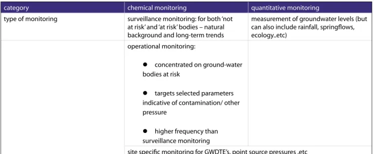
The ‘good status’ for groundwater bodies consists of two parts: ‘good chemical status’ and ‘good quantitative status’. Hence the monitoring required can be split into two main categories: chemical monitoring and quantitative (levels/flows) monitoring. Chemical monitoring is further divided into surveillance and operational monitoring.
Surveillance monitoring is the monitoring which aims to assess the long-term trends in natural concentrations or resulting from human activities and validate the assigned risk category. Operational monitoring focuses on ‘at risk’ bodies by monitoring in-between the ‘normal’ monitoring visits and selecting parameters representative of the local water quality pressures. Operational monitoring also allows validation of the risk assessment of the groundwater body.
Quantitative status monitoring is carried out to ensure that abstractions do not exceed the available resource in the groundwater body such that changes in water levels (or flows) do not negatively impact on dependent lakes, rivers, groundwater dependant terrestrial ecosytems (GWDTE) and coastal aquifers (danger of saline intrusion due to over-abstraction).
These categories are summarised in Table 1.
In addition to the above, Drinking Water Protected Area (DWPA) monitoring is also required. This will be focussed on significant potable sources and will incorporate monitoring undertaken for operational and surveillance purposes, additional data gathered by the Drinking Water Inspectorate, as well as new potable source monitoring.
Table 1. Overview of chemical and quantitative monitoring.
category chemical monitoring quantitative monitoring
type of monitoring surveillance monitoring: for both ‘not at risk’ and ‘at risk’ bodies – natural background and long-term trends
measurement of groundwater levels (but can also include rainfall, springflows, ecology..etc)
operational monitoring:
l concentrated on ground-water bodies at risk
l targets selected parameters indicative of contamination/ other pressure
l higher frequency than surveillance monitoring
Further information and context on the process being adopted in Northern Ireland can be found in the EHS publication Aquatic Monitoring Strategy 2006-2007 and Water Framework Directive Monitoring Plans (2006).
6.0
WFD Monitoring Network Design Principles
6.1
Guidance documents
In determining the proposed WFD groundwater monitoring network for Northern Ireland the following guidance documents were consulted:
l CIS Guidance Drafting Group GW1 – Monitoring Guidance for groundwater (2006)
l UK Technical Advisory Group (UK TAG) on the Water Framework Directive (WFD), 2005. Guidance on the selection of monitoring sites and building monitoring networks for surface water and groundwater. Public Working Draft
l Environmental Protection Agency (Ireland), 2006. Water Framework Directive Monitoring Programme
6.2
Key elements
6.2.1 Article 5 Risk Assessment
The requirement for monitoring of a groundwater body and associated receptors is partly defined by the risk category assigned to the groundwater body. As an output of initial characterisation of groundwater across NI, undertaken for Article 5 of the WFD, one of four risk categories have been assigned to each groundwater body for three broad pressure types; quantitative, diffuse and point. The results of two of these assessments are shown on Figures 2 and 3. Further characterisation work is ongoing associated with reviewing and refining these assessments to improve confidence in the risk category assigned.
The risk categories relate to the risk of a groundwater body failing to meet the ‘Good status’ benchmark in 2015. Categories 1a and 1b represent ‘at risk’ with different levels of confidence and categories 2a and 2b represent ‘not at risk’ with different levels of confidence. ‘Good status’ consists of ‘good chemical status’ determined by a variety of tests (including reference against a set of concentrations of certain chemical parameters) and ‘good quantitative status’. Good quantitative status is met by ensuring a sustainable balance between groundwater abstraction and recharge, taking into the account the needs of dependent ecosystems.
This risk assessment and ongoing refinements to it indicate where monitoring should be targeted to confirm or assess risk assessments and support final classification (for inclusion in the first River Basin Management Plan). Naturally the main effort in monitoring is rightly directed at those bodies determined to be at risk of failing to achieve good status. It is within these bodies that programmes of measures to improve the situation will be targeted hence the need for more detailed monitoring to support the design and justification of such measures. Chemical monitoring sites within ‘at risk’ groundwater bodies are for the most part designated as operational monitoring sites. Within both at risk and not at risk bodies some monitoring is still required to confirm risk assessments and to check that no deterioration in good status is occurring. Monitoring sites within ‘not at risk’ groundwater bodies are, for the most part, designated as surveillance monitoring sites
6.2.2. Grouping
To ensure an efficient and cost-effective monitoring network, the UK Technical Advisory Group (UKTAG, 2005) suggests the grouping of
groundwater bodies under certain conditions. The conditions include that the data gained from monitoring give reliable information on water quality, levels and trends, especially a possible increase in pollutant concentration across all the component bodies. In addition grouped groundwater bodies must have similar aquifer characteristics, pathway susceptibilities and pressures acting upon them. Grouped groundwater bodies defined as ‘not at risk’ need not to be adjacent to each other, whereas groundwater bodies ‘at risk’ do have to be next to or in close proximity to each other. The proposed UKTAG relationship between risk category, potential for grouping and monitoring density and type is described in more detail in the UKTAG monitoring guidance document (UKTAG, 2005).
6.2.3 Monitoring Site Representativity
Representativity applies to both the network as a whole and to component monitoring sites within the network. Certain attributes are considered essential/desirable for an individual monitoring site, including knowledge of the borehole geology and construction, a preference towards boreholes where abstraction occurs continuously and volumes pumped are ‘high’ (to give a good bulk sample of water from a reasonably sized ‘catchment’) and confidence that the water chemistry at the borehole is not unduly influenced by very local point source pollution pressures. In addition, the monitoring point, as part of the network, must be representative of the particular pressure-pathway scenario for which it is intended to monitor and, under certain circumstances be considered representative of similar scenarios at different geographical locations.
A more detailed description of this aspect and of the desirable criteria for individual monitoring points can be found in the UKTAG monitoring guidance (UKTAG, 2005).
6.2.4 Constraints
Compared with most parts of the UK and Republic of Ireland, the availability of existing suitable groundwater abstraction boreholes from which a subset can be selected for a representative WFD monitoring network is limited in Northern Ireland. As stated earlier, reliance on groundwater for water supply is relatively low and hence the availability of higher yielding sources from which to sample from is correspondingly limited.
In certain cases the requirement for establishment of new purpose drilled monitoring sites has been identified and it is intended that a programme of works will be undertaken between now and the end of the first River Basin Plan period to expand on the existing WFD network, partly informed by ongoing characterisation and development of improved conceptual understanding of groundwater flow systems.
6.3
Monitoring site selection approach
This section describes the general approach taken during the network site selection process.
Identification of existing groundwater sources that could potentially meet the necessary criteria was initiated by a review of both digital and paper records of groundwater sources including:
l Existing Northern Ireland groundwater monitoring network;
l Active and abandoned public water supply boreholes and springs;
l EHS abstraction dataset (incorporates sources regulated by the Drinking Water Inspectorate); and
l Known karstic discharge features.
Basic screening criteria (construction, predicted yield .etc) were used to exclude those sources where it was considered unlikely that they would meet the minimum standard required for a monitoring point, as recommended in the UKTAG monitoring guidance.
Once obviously inappropriate sites were discounted, the remaining sites were reviewed in a GIS framework within the context of the groundwater
body setting, pressure-pathway characteristics and relevant risk assessments.
For each groundwater body in turn, potential monitoring points were identified, taking into account where possible
i) conceptual understanding of the groundwater body ii) assigned risk to the groundwater body
iii) available details of monitoring points
iv) estimated yield (and by inference Zone of Contribution (ZOC)) v) pressure-pathway analysis
vi) guidance on density and type from UK and Republic of Ireland guidance documents
vii) likelihood that long-term access can be secured
Potential monitoring points were entered onto an Access database and a programme of site visits was undertaken to confirm or otherwise the appropriateness of sites. For sites considered suitable, permission to access for monitoring was sought.
Figure 1 Site selection process
On a body by body basis identify possibly suitable monitoring sites
Undertake desktop screening against guidance criteria to eliminate obviously unsuitable sites
Undertake GIS analysis of remaining potential sample points based upon groundwater conceptual model, preliminary ZOC estimates and pressure-pathway assessment
Field visits to each potential monitoring point for ground-truthing and local catchment assessment (prioritised).
Establish access agreements to desired sites
Undertake gap analysis after first iteration
Confirm outstanding network gaps and recommend alternative solutions (e.g. purpose drilling)
7.0
Chemical Monitoring
7.1
Operational network
7.1.1 Overview
The overall objectives of the chemical operational network, as set out in Annex V of the WFD, are to:
l establish the chemical status of those groundwater bodies or groups of bodies determined to be at risk of failing to achieve good status,
l identify the presence of any long term, anthropogenically induced, upward trend in the concentration of a pollutant.
Operational monitoring will also be critical for determining the scale and nature of programmes of measures that may be required and for checking the effectiveness of such measures over time.
The three main pressure categories that are likely to be putting a
groundwater body or group of bodies at risk, as identified during the Article 5 risk assessment are;
Diffuse pressures - mainly from the dominant agricultural land use across Northern Ireland with key potential pollutants being nitrates, phosphorus and pesticides
Point pressures - a variety of potential sources including quarrying, land-filling and contaminated land.
Urban pressures - reflecting a concentration of multiple point source pressures, impacts from which are difficult to attribute such as leaking sewers, hydrocarbon leakages, solvent spillages and contaminated land. 7.1.2 Sites
Sites selected for inclusion within the operational monitoring network comprise those sites within groundwater bodies at risk as shown in Figure 2.
As risk assessment and conceptual understanding develops, in particular relating to point source pressures, it is anticipated that this network will expand.
Figure 2 Locations of monitoring sites for inclusion in chemical monitoring network
7.1.3 Analytical Suites
For each monitoring round each site will have the standard basic suite (Appendix 1) undertaken incorporating:
l Oxygen content l PH value l Conductivity l Nitrate l Ammonium l Major ions
l Certain minor ions and metals
Depending on the pressure-pathway assessment associated with the monitoring point, an additional point, urban and/or diffuse suite (Appendix 1) will also be undertaken. In certain cases specific determinands will be targeted.
7.1.4 Monitoring Frequency
The frequency of monitoring will be determined by the conceptual model of the system to be monitored including the local hydrogeological setting, along with the expected variability of the determinands reflecting the relevant pressure(s).
The selected frequency for each site will be guided by the minimum frequency recommendations as described in the UKTAG monitoring guidance and summarised in table 2.
Table 2. Minimum monitoring frequencies for operational monitoring suggested by the UK Technical Advisory Group (UKTAG)
7.2
Surveillance network
7.2.1 Overview
The overall objectives of the chemical surveillance network, as set out in Annex V of the WFD, are to:
l Supplement and validate the impact assessment procedure
l Provide information for use in assessment of long terms trends both as a result of changes in natural conditions and through anthropogenic activities
Surveillance monitoring is required for all groundwater bodies or groups of bodies whether they are at risk or not.
The surveillance monitoring network will thus comprise all monitoring sites within the ‘not at risk’ bodies along with the majority of those within the operational network where they are not associated with specific point source pressure monitoring.
7.2.2 Sites
Sites selected for inclusion within the surveillance monitoring network comprise the majority of those sites shown on Figure 2.
Aquifer Flow Type
Confined Unconfined
Intergranular flow significant Fracture flow only Karst flow Significant deep flows common Shallow flow Higher vulnerability groundwater Continuous pressures
Annual Twice per year Twice per year Quarterly Quarterly Seasonal/
intermittent pressures
Annual Annual As appropriate As appropriate As appropriate
Lower vulnerability groundwater
Continuous pressures
Annual Annual Twice per year Twice per year Quarterly Seasonal/
intermittent pressures
Annual Annual As appropriate As appropriate As appropriate
-As risk assessment and conceptual understanding develops, in particular relating to point source pressures, it is anticipated that this network will expand.
7.2.3 Analytical suites
For each monitoring round each site will have the standard basic suite (appendix 1) undertaken incorporating:
l Oxygen content l PH value l Conductivity l Nitrate l Ammonium l Major ions
l Certain minor ions and metals
Depending on the pressure-pathway assessment associated with the monitoring point, an additional urban and/or diffuse suite (Appendix 1) will also be undertaken.
7.2.4 Monitoring Frequency
The frequency of monitoring will be determined by the conceptual model of the system to be monitored including the local hydrogeological setting, along with the inherent variability of the determinands reflecting the relevant pressure(s).
The selected frequency for each site will be guided by the minimum frequency recommendations as described in the UKTAG monitoring guidance and summarised in Table 3.
Table 3. Minimum monitoring frequencies for surveillance monitoring suggested by the UK Technical Advisory Group (UK TAG).
7.3
Quantitative network
7.3.1 Overview
The overall objectives of the quantitative network are to assist with characterisation and to confirm or otherwise quantitative status assessments. Information obtained from this network will also assist in interpretation of chemical monitoring data and will support the design and implementation of programmes of measures.
As described previously, within Northern Ireland, overall resource
quantitative pressures are significantly less than that found in many other parts of the UK. In addition, a significant proportion of Northern Ireland is comprised of poorly productive bedrock aquifers where there is restricted value in undertaking traditional borehole water level programmes to assess overall regional resource status.
7.3.2 Sites
Monitoring sites selected for inclusion within the quantitative network are concentrated within those bodies determined to be ‘at risk’ from quantitative pressures (Figure 3). It should be noted that the precautionary approach taken under the Article 5 characterisation resulted in some large groundwater bodies being put at risk due to a relatively local abstraction
Aquifer Flow Type
Confined Unconfined
Intergranular flow significant Fracture flow only Karst flow Significant deep flows common Shallow flow
Initial frequency – core & additional parameters
Twice per year Quarterly Quarterly Quarterly Quarterly Long term frequency – core parameters Generally high-mod transmissivity
Every 2 years Annual Twice per year Twice per year Twice per year
Generally low transmissivity Every 6 years Annual Annual Annual Twice per year Additional parameters (on-going validation) Every 6 years Every 6 years Every 6 years every 6 year
-pressure associated with one dependent river water body. Hence monitoring within such bodies will be targeted in these areas 7.3.3 Monitoring frequency
Sites identified include both boreholes and springs. Minimum monitoring frequency will be monthly initially, with certain sites selected for more frequent monitoring using data loggers. Where sites are suitable and where such information will assist with improving the local hydrogeological conceptual understanding, groundwater chemical sampling will be carried out at least once and analysed for relevant parameters.
Figure 3 Locations of monitoring sites for inclusion in quantitative monitoring network
7.4
Drinking Water Protected Area network
The WFD requires that monitoring programmes are able to assess the achievement of Drinking Water Protected Area (DWPA) objectives defined under Article 7. Although the WFD does not introduce any additional specific monitoring criteria to those defined in Annex V for surveillance and operational monitoring, the programmes must be adequate to provide accurate and reliable data to support DWPA management and assessment. For instance this information will be needed to identify any deterioration in the quality of abstracted raw water that may potentially lead to an increase in the level of purification/treatment.
In Northern Ireland, regulation (and monitoring) of both public water and more significant private water potable abstractions is managed by the Drinking Water Inspectorate.
Monitoring will be in accordance with the programmes set out for surveillance and/or operational monitoring in terms of determinand selection and taking into account Drinking Water Quality standards. Monitoring of untreated water will be undertaken at a representative selection of significant potable groundwater abstractions (1). Frequency of monitoring will be a minimum of once per River Basin Planning Cycle. Monitoring locations and frequency will be informed by regulatory monitoring data collected by the Drinking Water Inspectorate for such sources.
7.5
Species and Habitat Protected Areas
Chemical and quantitative monitoring is required in groundwater bodies associated with Species and Habitat Protected Areas to refine risk assessments and determine whether any impacts identified at such sites may be caused by groundwater influences. The interaction between groundwater and such ecological systems is frequently complex and very dependent on site specific hydrogeological conditions. Similar to most other parts of the UK and Ireland, only limited understanding of such interactions is currently available.
Quantitative and chemical monitoring at one site which has been confirmed as groundwater dependent will be undertaken initially and is included in the surveillance and quantitative monitoring programmes described above. Monitoring at additional sites is intended, following improvement in conceptual understanding and risk assessment.
Monitoring will be carried out at a frequency and density sufficient to allow an understanding of the relationship between the species/habitat and surrounding groundwater and will be integrated with additional ecological monitoring where relevant.
(1) – A significant potable source is defined as one intended for human consumption that comes within the requirements of the Drinking Water Directive (Directive 80/778/EEC as amended by Directive 98/83/EC). That is a source where water abstracted from an individual supply provides 10 m3 per day or more as an average or serves at least 50 persons, unless supplied as a part of a commercial or public activity in which cases the
7.6
Prevent or Limit Monitoring
In accordance with Articles 4, 11 and 17 of the WFD, Member States should assess the effectiveness of Programmes of Measures introduced to prevent or limit the inputs of pollutants and/or the deterioration of the status of groundwater. The proposed surveillance and operational network will contribute significantly to this but there may be a need for further additional monitoring, for example to assess any impact from specific point sources. It is initially intended to undertake additional monitoring at sources out-with the WFD monitoring network. Monitoring sites managed under other regulatory regimes such as the Integrated Pollution Prevention and Control (IPPC) Directive 96/61/EC will also be assessed.
Data collected from any additional monitoring from existing or newly installed sites will be used to refine the risk assessment and inform the classification of groundwater bodies as well as influencing the ongoing refinement of the WFD monitoring network.
8.0
Network Development
In response to ongoing refinement of groundwater body characterisations, improved conceptual understanding and data collation from the network, regular review of the adequacy of the network to meet WFD requirements will be undertaken, in line with CIS monitoring guidance for groundwater (2006). Additional sites are already planned for the first River Basin Planning cycle. The close management of the network will be particularly necessary for Northern Ireland due to the uncertainties over ongoing use and by implication, availability for monitoring, of public water supply groundwater sources.
9.0
Confidence and Precision
An assessment of confidence in the status assessment is key in the justification of corrective action. When assessing confidence in groundwater data, the UKTAG monitoring guidance (UKTAG, 2005) indicates that a combination of hydrogeological knowledge and statistics is important. Hydrogeological knowledge will be provided through the selection of appropriate monitoring points. Once appropriate monitoring points and sampling frequencies have been selected, confidence will be assessed using standard statistical tests on the available data to identify upper and lower confidence limits associated with the data. Given the hydrogeological variability and frequency of groundwater sampling, it is intended that the statistical tests will generally be based on at least six years of data.
Confidence in the quality of data being collected will be managed by ensuring sample collection, storage and analysis follows an auditable process. Sample collection, transport and storage will be undertaken in accordance with recognised European or National procedures such as BS6068: Part 6:Section 6.11:1993 Water Quality Sampling. Guidance on Sampling of Groundwaters and BS EN ISO 5667-3: Guidance on Preservation and Handling of Samples. Analysis of samples will be undertaken using only laboratories with a recognised QA/QC procedure in place.
10.0 Member State Cross-Border Monitoring
A number of groundwater bodies are shared with the Republic of Ireland along the border area. There has been co-operation between the two Member States in delineating these groundwater bodies and in correlating risk assessments for the Article 5 report.
The majority of these bodies are comprised of poorly productive aquifer bedrock where the dominant groundwater flow is restricted to relatively shallow depth with local discharge to surface waters. There are no cross-border superficial (sand/gravel) groundwater bodies. Article 5 risk assessment indicated no bodies at risk from quantitative or point pressures and only a small number of bodies potentially at risk from diffuse pressure. Where monitoring sites have been identified within cross-border
groundwater bodies or groups of bodies, parameter suites and sampling frequency will be co-ordinated and data will be shared between the two Member States.
REFERENCES
CIS Drafting Group GW1, 2006. Monitoring Guidance for Groundwater. Environment and Heritage Service, 2006. Aquatic Monitoring Strategy 2006-2007 and Water Framework Directive Monitoring Plans (1)
Environmental Protection Agency (Ireland), 2006. Water Framework Directive Monitoring Programme (2)
McConvey P J. 2005. Water Framework Directive: Aquifer classification scheme for Northern Ireland. Geological Survey of Northern Ireland. Commissioned report
UK Technical Advisory Group (UK TAG) on the Water Framework Directive (WFD), 2005. Guidance on the selection of monitoring sites and building monitoring networks for surface water and groundwater. Public
Working Draft (3)
Water Service, 2003. Water Resources Strategy 2002-2030
(1) - available from www.ehsni.gov.uk (2) - available from www.epa.ie (3) - available from www.wfduk.org
Standard Suite
Diffuse Suite
Point Suite
Urban Monitoring
GWSTANDARD -1Carried out for each sample
pH, Temperature, Dissolved Oxygen, Electrical Conductivity (measured at well-head and in lab)
Alkalinity (CaCO3), Nitrite, Nitrate, Ammonia Hardness total, Alkalinity total Calcium, Magnesium, Sodium Potassium, Chloride, Sulphate
Molybdate Reactive Phosphorus, Total Phosphate Iron, Manganese
TOC mg/l C
Cations (tot), Anions (tot) Ionic Balance GWSTANDARD -2
Carried out for selected samples
Cadmium, Arsenic, Zinc, Mercury, Lead, Copper, Boron, Aluminium, Nickel, Chromium, Fluoride, Barium, Molybdenum, Silver, Cobalt, Strontium, Beryllium, Antimony, Uranium, Selenium, Silica Total and Faecal Coliforms Radon
GWDIFFUSE A range of pesticides generally to include the following which reflect dominant use and/or identified detections in historical monitoring.
Atrazine, Simazine, MCPA, MCPP, Isoproturon, 2-4 D, Diuron, DDT, Lindane, Primicarb, Mancozeb, Glyphosate, Cypermethrin, Diazinon, Pentachlorophenol, Asulam, Dicamba, Dicloroprop, 2, 4, 5,T, 2,4,6, Trichlorophonol, DDE(op), DDE(pp), Heptachlor, Oxadixyl, Triclopyr, Metaxyl
For each monitoring point an assessment of other parameters which reflect local diffuse land use will also be undertaken and included in this suite where relevant
GWPOINT GWStandard-1 suite plus point pressure specific suite
GWURBAN
To include the following groups for background monitoring and selected groups where specific pressures identified Solvents Hydrocarbons PAH Phenols Others
Drinking Water Protected Area Monitoring
GWDWPA As per standard suite plus any additional parameters dependent upon local
treatment issues and through reference against Drinking Water Inspectorate analysis range
17 Antrim Road Lisburn BT28 3AL Tel: (028) 9262 3195 Fax: (028) 9262 3011 www.ehsni.gov.uk