3 9 3
Miocene–Quaternary sediments, probably supplied by a Palaeo-Maritsa river. The drainage diversion cut off the sediment supply, with the result that the terrigeneous sediments of the Marmara Sea were depressed to a water depth of 1150 m.
Keywords:Aegean, Balkans, North Anatolian Fault, drainage patterns, tectonics.
Faulting has a strong influence on the evolution of fluvial systems by controlling drainage pattern, drainage divides, ero-sion, and the morphology of the flood plain (e.g. Keller & Pinter 1996). It may even lead to drainage reversal, as occurred temporarily in the Alaskan rivers during the 27 March 1964 Alaska earthquake (Plafker 1969). In this study we use geomor-phological, geological and geophysical data to illustrate a case of tectonically induced drainage reversal and subsequent stream capture of a major river system in the northeastern Aegean. We test the hypothesis that atc. 1.5 Ma the alluvial Maritsa River in the Balkans was diverted from the Marmara to Aegean Sea following coseismic uplift along the northern margin of the Marmara Sea (Fig. 1).
Drainage pattern of the Maritsa River
The Maritsa River drains most of Bulgaria south of the Balkan Mountains, the eastern Rhodope Mountains of Greece and the European part of Turkey (Fig. 1). It is 513 km long, has a drainage area of 53 000 km2and flows into the Aegean Sea along
the border between Turkey and Greece. The drainage basin of the Maritsa River is elongated in a NW–SE direction (Fig. 1). The Maritsa River flows SE along the basin midline downstream to the region of Edirne, then makes a SW turn, and flows perpendicular to the general trend of its drainage area before joining the Aegean Sea. This produces a strong transverse topographic asymmetry south of Edirne. For a stream network that formed and continues to flow in a stable setting, the drainage area to the left and right of the trunk channel should be approximately equal, provided there are no major lithological controls or local climatic effects (e.g. Keller & Pinter 1996). This is also valid for the Maritsa River down to Edirne. However, the basin symmetry breaks downstream of the southwesterly bend. The drainage basin left of the main Maritsa trunk (facing downstream) makes up 66% of the total drainage area. For the region south of Edirne the drainage asymmetry increases to 84%. Tributaries of most large rivers are of similar size and are symmetrically arranged around the trunk channel. In contrast, the alluvial Ergene River in Thrace forms a 281 km long and asymmetric tributary to the Maritsa (Fig. 1).
The transverse topographic asymmetry, the basin asymmetry, and the tributary anomaly were not present in a Palaeo-Maritsa
river draining into the Marmara Basin through the Ergene River (Fig. 1). The drainage diversion from the Palaeo-Maritsa to the Maritsa River is related to the uplift of the northern margin of the Marmara Sea.
Uplift of the northern margin of the Marmara Sea
The Marmara Sea is a small intracontinental sea between the Black and Aegean seas (Fig. 1). It owes its origin to the North Anatolian Fault, a 1600 km long transform fault between the Eurasian and Anatolian plates (e.g. Barka 1992). Global position-ing system (GPS) studies indicate that the Anatolian plate is moving westward with respect to the Eurasian plate at a rate of c. 2 cm a1(McCluskyet al. 2000). This displacement manifests
itself through destructive earthquakes along the North Anatolian Fault. The North Anatolian Fault is believed to have nucleated during Late Miocene time in the east and propagated westwards reaching the Aegean region probably during Pliocene time (Tu¨ysu¨z et al. 1998). It crosses through the centre of the Marmara Sea and causes the formation of three marine depres-sions, over 1100 m deep, separated by submarine ridges and bounded to the north and south by shelf areas (Fig. 2).
The strongest evidence for active regional uplift of the north-ern margin of the Marmara Sea is its asymmetric drainage area. In the south, between the Dardanelles Strait and the I˙zmit Bay, several medium-sized rivers drain an area of 30 562 km2into the
Marmara Sea (Fig. 1). In contrast, the drainage area in the north is very small (4438 km2) and not a single important stream flows
to the Marmara Sea from the north. This asymmetry is even more striking considering that the ratio of the length of the northern shoreline to the total shoreline of the Marmara Sea is 0.47, whereas that of the northern drainage area to the total drainage area is only 0.13. Active uplift is also reflected in the morphology of the northern Marmara shore, characterized by steep cliffs several tens of metres high, typical of emergent coastlines. Pleistocene marine terrace deposits, which occur sporadically throughout the northern margin of the Marmara Sea, but are conspicuously absent along its southern margin, are further evidence for recent uplift (Sakinc¸ & Yaltirak 1997). These deposits contain Mediterranean faunas and range in thickness from ,1 m to 37 m. The base of the Pleistocene terrace deposits lies 4–40 m above present sea level. Shells in
the terraces in the I˙zmit Bay have been dated by thermoluminis-cence, U/Th and14C methods to Mid- to Late Pleistocene time
(260, 130 and 40 ka; Paluskaet al. 1989).
Thrace north of the Marmara Sea is a flat-lying erosion surface with an average altitude ofc. 120 m. The drainage divide north of the Marmara Sea is a chain of gently rounded hills at heights of 160–230 m. Poorly consolidated, fluviatile sandstones and pebbly sandstones, up to 1500 m thick, underlie most of the Thracian erosion surface. Sands in the basal part of this Ergene Formation near C¸ orlu contain Late Miocene (Turolian, 9.0– 5.2 Ma) vertebrate faunas (Kaya & Heissig 2001). In the south, the Ergene Formation lies unconformably over alkali basaltic flows and Oligocene sandstones. The absence of the Ergene Formation along the northern margin of the Marmara Sea (Fig. 3) is due to erosion, supported by the widespread cross-bedding in the sands of the Ergene Formation indicating southward palaeocurrents (Umut 1988; C¸ ag˘layan & Yurtsever 1998) whereas the unconformity surface slopes northward.
The resistant basaltic flows north of the Marmara Sea occur as erosional outliers over the easily eroded Oligocene sandstones and largely control the present drainage divide (Fig. 2). Ar/Ar volcanic glass, and K/Ar whole-rock ages of the basalts range between 8 and 6 Ma (Paton 1992; Ercanet al. 1999), and provide independent evidence for a Late Miocene and younger age for the Ergene Formation. The upper parts of the Ergene Formation are regarded as being of Pliocene age (Perinc¸ek 1991; Turgutet al. 1991). The Thracian erosion surface must have formed after latest Miocene time, afterc. 6 Ma. A widespread Late Pliocene– Early Quaternary erosion surface has been described from the northern Thracian Basin in Bulgaria (Burchfielet al. 2000) and may imply a similar age for the Thracian erosion surface. Figure 3 shows two cross-sections from the Thracian erosion surface to the Western Marmara Basin. These sections illustrate that south of the Ergene River the Thracian erosion surface is gently inclined northward at 0.3–0.58, and is abruptly terminated by the
Northern Boundary Fault located along the northern submarine slope of the Marmara Sea (Fig. 2).
Uplift of the Thracian erosion surface occurs along the footwall of the Northern Boundary Fault (Fig. 2). Footwall uplift along large normal faults is a common and widely described phenomenon in extensional areas. As the footwall uplift is related to isostatic adjustment during vertical movements, uplift would also be expected along the transtensional Northern Boundary Fault, which forms the northern arm of a major negative flower structure (Fig. 3; Wonget al. 1995; Okayet al. 1999; Parke et al. 1999). Footwall uplift generally produces escarpments. Absence of such escarpments in the northern Marmara Sea is related to the footwall lithology of soft, easily erodable Oligocene sandstones (see Goldsworthy & Jackson, 2000).
Footwall uplift along the Northern Boundary Fault relative to the present sea level, estimated from the tilt of the Thracian erosion surface, isc. 500 m. This is about 13% of the hanging-wall subsidence ofc. 4 km based on the present water depth and the thickness of Upper Miocene–Quaternary sediments in the Western Marmara Basin (Fig. 3). This value is similar to the ratio of footwall uplift to hanging-wall subsidence observed in well-studied normal fault systems (e.g. Savage & Hastie 1966; Armijoet al. 1996). The uplift is effective over a distance ofc. 30 km north of the Northern Boundary Fault. This can be deduced from the profile of the Ergene River (Fig. 3b): the profile has a shallow gradient of 0.0168 (0.28 m km1) along
most of the river but the gradient increases sharply to 0.318
(5.4 m km1) c. 30 km north of the Northern Boundary Fault. This gives a flexural block rotation ofc. 18 for the footwall of the Northern Boundary Fault.
Four lines of evidence indicate recent uplift along the northern margin of the Marmara Sea: (1) drainage asymmetry of the Marmara Sea; (2) northward tilt of the Thracian erosion surface; (3) erosional removal of the Ergene Formation along the northern
Fig. 1. Map of NW Turkey and the Balkans showing the drainage areas of the Maritsa River and the Marmara Sea. The dashed line indicates a possible course of the Palaeo-Maritsa river. Basins below 1000 m are stippled. The fault geometry in the Marmara Sea is after Okayet al. (2000) and Le Pichonet al. (2001), and representative GPS vectors after Straub & Kahle (1995). The inset shows the present tectonics of the eastern Mediterranean.
margin of the Marmara Sea; (4) raised Pleistocene marine terraces. Further indirect evidence for uplift comes from a tectonically active sedimentary basin in the Marmara Sea, which has lost its sediment source.
A Late Miocene–Pliocene basin without a current sediment source
The Western Marmara depression is forming along the releasing bend between the Ganos and Central Marmara fault segments of the North Anatolian Fault (Okayet al. 1999). It is rhomb-shaped with a side length of c. 15 km, with steep margins and a flat basin floor at a depth of 1150 m (Fig. 2). Multichannel seismic reflection studies show that the basin fill is highly asymmetric, increasing in thickness from essentially zero at the toe of the submarine slope to 2.5 km adjacent to the North Anatolian Fault (Fig. 3a; Okayet al. 1999). The increase in thickness of basinal strata towards the Central Marmara Fault, and the similarity between the isopachs and the shape of the Western Marmara depression indicate that the basinal sediments were deposited in the currently active strike-slip tectonic environment and thus represent syntransform sediments.
There are no well data in the Western Marmara Basin to characterize directly the age and facies of the syntransform sediments. However, the results of the Marmara-1 well drilled in another asymmetric fault-bend basin in the southern Marmara Sea have direct relevance to the stratigraphy in the Western Marmara Basin. The Marmara-1 well has cut through,40 m of Quaternary marine clay overlying Upper Miocene(?)–Pliocene limnic to fluvio-deltaic sediments, 2100 m in thickness (Ergu¨n & O¨ zel 1995). Lower–Middle Miocene sandstones crop out in southern Thrace south of the Ganos segment of the North Anatolian Fault. These sediments bear no evidence, in terms of facies and thickness distribution, that they were deposited in the vicinity of a major strike-slip fault, which in turn implies that the syntransform sediments in the Western Marmara Basin are of Late Miocene age and younger (Okay et al. 1999). This is in agreement with the generally accepted view of Late Miocene inception and gradual westward propagation of the North Anatolian Fault (S¸engo¨ret al. 1985; Barka 1992). The Pliocene deposits around the Marmara Sea are continental, indicating that the Marmara Sea was a land area during this interval, possibly occupied by large lakes (Go¨ru¨ret al. 1997; Sakinc¸et al. 1999). Thus, strong circumstantial evidence indicates that the
syntrans-Fig. 2. Map of the Marmara region showing active faults. The topographic contours are at 250 m intervals, and the bathymetric contours in the Marmara Sea are at 50, 100 and 200 m, then at every 200 m. Basins deeper than 1000 m are stippled. The fault geometry in the Marmara Sea is after Smithet al. (1995) and Okayet al. (2000). WMB, Western Marmara Basin; NBF, Northern Boundary Fault; M-1, Marmara-1 well; KM, Kuzey Marmara well. (For location of the map, see Fig. 1.)
form sediments in the Western Marmara Basin are Late Mio-cene–Pliocene continental sediments topped by a thin veneer of Quaternary marine clay. The sill at the Dardanelles strait, currently 65 m deep, was a barrier to the influx of marine waters into the Marmara Basin during Late Miocene and Pliocene time.
A longitudinal seismic reflection profile across the Western Marmara Basin is shown in Fig. 4. In this section the syntrans-form sediments, up to 1.7 km thick, show a distinct southwest-ward progradation, indicating a sediment source that lies NE of
the Western Marmara Basin. However, at present there is no sediment source area north of the Marmara Sea (Fig. 2). Furthermore, Pliocene sediments are absent on the northern shelf, as revealed by the Kuzey Marmara well, which cuts through 20 m of Quaternary marine beds overlying 1100 m of Oligocene–Eocene clastic rocks (Ergu¨n & O¨ zel 1995). Sediment transport from the south is unlikely, as sediment carried by rivers in the south is trapped between the normal fault blocks on the southern shelf of the Marmara Sea (Smithet al. 1995).
Fig. 3. (a) Cross-sections across the Thracian erosion surface and the Marmara Sea. (b) Longitudinal profile of the Ergene River. (For the location of X, Y and Z, see Fig. 2.)
Fig. 4. Time-migrated multichannel seismic reflection profile along the axis of the Western Marmara Basin. The southwestward progradation of the basinal sediments, indicating a northerly sediment source, should be noted. (For location of the profile, see Fig. 2) (modified from Okayet al. 1999).
The junction angle between a stream and its tributary depends on the ratio of their respective gradients (Horton 1945):
cosƼtanŁr=tanŁt
whereÆis the junction angle between the tributary and receiving stream, Łr is the gradient of the receiving stream andŁt is the
gradient of the tributary.
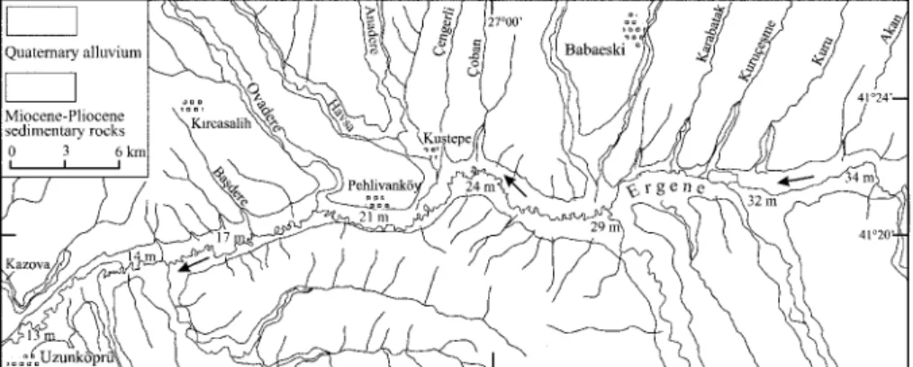
Field studies have shown that this Horton equation predicts the stream junction angles with an uncertainty of 5–108 (e.g. Lubowe 1964). In mature drainage systems, junction angles are always,908and obtuse angles are not observed. However, for a distance of 24 km east of Uzunko¨pru¨, many tributaries of the Ergene River have junction angles.908, in spite of the Horton equation indicating junction angles of c. 758 for the large tributaries (Fig. 6). Even long and well-entrenched alluvial tributary streams, such as the Ovadere, of 30 km length, have junction angles as high as 1208 (Fig. 7). This stretch of the Ergene River is characterized by very low gradients (0.028 or 0.4 m km1) and probably represents the least modified segment of the Palaeo-Maritsa river. In this segment, the tributaries of the
Basin.
Uplift along the northern margin of the Marmara Sea has resulted in permanent drainage reversal of the Ergene segment of the Palaeo-Maritsa river and subsequent river capture by a small stream that was flowing into the Aegean Sea. A sequence of lacustrine limestone and marl, ,40 m thick, has been described in Thrace north of the Ergene River (Fig. 2; Umut 1988; Sakinc¸ et al. 1999). These limestones, which lie over the Ergene Formation, may represent lake sediments in the Maritsa drainage basin that would have accumulated in the period between the drainage reversal and headward capture by a small stream draining into the Aegean Sea.
An uplift of c. 0.5 km along the footwall of the Northern Boundary Fault is required to achieve the present northward dip of the Thracian erosion surface and invert the flow of the Ergene River (Fig. 3). This uplift may have occurred over a period ofc. 1.5 Ma assuming an uplift rate of 0.3 m ka1, as calculated from
the dated terraces south of the I˙zmit Bay (Paluska et al. 1989). This date is similar to the age of erosion surface in Thrace (Burchfielet al. 2000) suggesting that the drainage diversion of
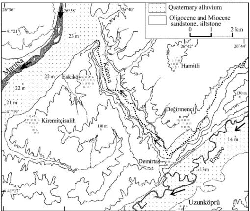
Fig. 5. Map of the region of Kazova stream, a possible former connection between the Maritsa and Ergene rivers. It should be noted that although the Kazova stream flows into Maritsa, the floodplain of Maritsa is at a higher elevation than that of its tributary Ergene River. (For location, see Fig. 2.)
the Palaeo-Maritsa river occurred in Early Quaternary time. The drainage diversion terminated sediment supply to the Western Marmara Basin, which at present lies at 1150 m water depth. Tectonically induced drainage diversion provides a possible mechanism for basin starvation and abrupt change in deposi-tional facies, in the case of the Marmara Sea from fluvial–limnic sedimentation to the deposition of deep marine mudstones.
The authors thank M. Siyako and T. Kaya for discussion and information, and R. Collier, E. Keller, B. Natalin and O. Tu¨ysu¨z for perceptive reviews. This study was supported by TU¨ BI˙TAK grants YDABC¸AG 100Y079 and 199Y082.
References
Armijo,R.,Meyer,B.,King, G.C.P.,Rigo,A. &Papanastassiou, D.1996. Quaternary evolution of the Corinth rift and its implications for the late Cenozoic evolution of the Aegean.Geophysical Journal International,126, 11–53.
Barka, A.A.1992. The North Anatolian Fault Zone.Annales Tectonicae,6, 164– 195.
Burchfiel, C.B.,Nakov, R.,Tzankov, T.& Royden, L.H. 2000. Cenozoic extension in Bulgaria and northern Greece: the northern part of the Aegean extensional regime. In:Bozkurt, E.,Winchester,J.A.& Piper, J.D.A. (eds) Tectonics and Magmatism in Turkey and the Surrounding Area.
Geological Society, London, Special Publications,173, 325–352.
C¸ ag˘ layan, M.A.&Yurtsever, A.1998.Geological map and explanatory notes of the Burgaz-A3 and A4, Edirne B-2 and B-3, Kirklareli-B4, B5, B6 and C6 sheets, scale 1:100 000. Maden Tetkik ve Arama Genel Mu¨du¨rlu¨g˘u¨, Ankara. Ercan, T.,Tu¨ rkecan, A.,Guillon, H.,Satir, M.,Sevin, D.&S¸ arog˘ lu, F.
1999. Features of the Tertiary volcanism around Sea of Marmara.Bulletin of Mineral Research and Exploration,120, 97–118.
Ergu¨ n, M.&O¨ zel, E.1995. Structural relationships between the Sea of Marmara basin and the North Anatolian Fault Zone.Terra Nova,7, 278–288. Goldsworthy, M.&Jackson, J.2000. Active normal fault evolution in Greece
revealed by geomorphology and drainage pattern.Journal of the Geological Society, London,157, 967–981.
Go¨ ru¨ r, N., C¸ ag˘ atay, M.N., Sakinc¸ , M., Su¨ mengen, M., S¸ entu¨ rk, K., Yaltirak, C.&Tchapalyga, A.1997. Origin of the Sea of Marmara as deduced from Neogene to Quaternary paleogeographic evolution of its frame. International Geological Review,39, 342–352.
Horton, R.E.1945. Erosional development of streams and their drainage basins, hydrophysical approach to quantitative morphology. Geological Society of America Bulletin,56, 275–370.
Kaya, T. & Heissig,K. 2001. Late Miocene Rhinocerotids (Mammalia) from Yulafli (C¸ orlu–Thrace/Turkey).Geobios,34, 457–467.
Keller, E.A.& Pinter, N.1996. Active Tectonics. Prentice Hall, Englewood Cliffs, NJ.
Le Pichon,X.,S¸ engo¨ r, A.M.C.,Demirbag˘ , E. & 9others2001. The active Main Marmara Fault.Earth and Planetary Science Letters,192, 595–616. Lubowe, J.K. 1964. Stream junction angles in the dentritic drainage pattern.
American Journal of Science,262, 325–339.
McClusky, S., Balassanian, S., Barka, A. & 25 others 2000. Global Positioning System constraints on plate kinematics and dynamics in the eastern Mediterranean and Caucasus.Journal of Geophysical Research,105, 5695–5719.
Okay, A.I.,Demirbag˘ , E.,Kurt, H.,Okay, N.&Kus¸c¸ u, I˙.1999. An active, deep marine strike-slip basin along the North Anatolian fault in Turkey.Tectonics,
18, 129–148.
Okay, A.I.,Kas¸lilar-O¨ zcan, A.,I˙mren, C.,Boztepe-Gu¨ ney, A.,Demirbag˘ , E. &Kus¸c¸ u, I˙.2000. Active faults and strike slip basins in the Marmara Sea, northwest Turkey.Tectonophysics,321, 189–218.
Paluska, A.,Poetsch, T. &Bargu, S.1989.In:Zschau, J. &Ergu¨ nay, O. (eds) Tectonics, paleoseismic activity and recent deformation mechanism in the Sapanca–Abant region (NW Turkey, North Anatolian Fault Zone) Proceedings of the Turkish–German Earthquake Research Project. Istanbul University, 18–32.
Parke, J.R.,Minshul, T.A.,Anderson, G.& 6others1999. Active faults in the Sea of Marmara, western Turkey, imaged by seismic reflection profiles.Terra Nova,11, 223–227.
Paton,S. 1992.The relationship between extension and volcanism in western Turkey, the Aegean Sea and central Greece. PhD thesis, Cambridge University.
Perinc¸ ek,D.1991. Possible strand of the North Anatolian Fault in the Thrace Basin, Turkey—an interpretation.AAPG Bulletin,75, 241–257.
Plafker, G.1969.Tectonics of the March 27, 1964 Alaska Earthquake,543-1. US Geological Survey Professional Paper.
Sakinc¸ , M.&Yaltirak, C.1997. Marine Pleistocene deposits and Pleistocene paleogeography of the southern Thrace (in Turkish).Maden Tetkik Arama Dergisi,119, 43–62.
Sakinc¸ , M.,Yaltirak, C.&Oktay, F.Y.1999. Paleogeographical evolution of the Thrace Neogene Basin and the Tethys–Paratethys relations at north-western Turkey (Thrace). Palaeogeography, Palaeoclimatology, Palaeoecol-ogy,153, 17–40.
Fig. 6. Map showing the anomalous junction angles between the tributaries and the Ergene River between Uzunko¨pru¨ and Kustepe. The angles return to normal farther east. The altitudes of the Ergene flood plain are also shown. (For location, see Fig. 2.)
Fig. 7. Junction angles between the tributaries and the main trunk of the Ergene River plotted against distance from Uzunko¨pru¨. The elevation of the floodplain of the Ergene River is also shown. The inset illustrates the parameters plotted.