Uncovering a Shipwreck in the Pamlico Sound: Connecting Science to a Community
By India Mackinson
Senior Honors Thesis
University of North Carolina at Chapel Hill Environment, Ecology and Energy Program
Acknowledgments
Thank you to my advisor Lindsay Dubbs for her patience and confidence in my work. I would also like to thank Nathan Richards and Bland Simpson for teaching me about
maritime archaeology, writing, and our wonderful coast.
Table of Contents
INTRODUCTION ... 4
LITERATURE REVIEW: WEBSITES AS SCIENCE COMMUNICATION TOOLS ... 7
METHODS ... 14
ARTICLES ... 14
Reporting ... 14
Writing ... 16
Limitations ... 17
WEBSITE ... 17
Design Process ... 17
Coding ... 20
Limitations ... 20
ARTICLES ... 21
ARTICLE 1:PRELUDE TO IDENTIFICATION ... 21
ARTICLE 2:THE ART AND SCIENCE OF MARITIME ARCHEOLOGY ... 24
ARTICLE 3:SHIPWRECK PRESERVATION ... 28
ARTICLE 4:FROM THE PACIFIC TO THE PAMLICO ... 32
ARTICLE 5:ISLAND ADAPTIONS ... 35
ARTICLE 6:SHIPWRECK ECOLOGY:FROM MAN’S TRAGEDY TO NATURE’S NEW HOME ... 39
ARTICLE 7:CLIMATE CHANGE AND COASTAL INFRASTRUCTURE ... 44
WEBSITE ... 49
DISCUSSION ... 49
CONCLUSION... 51
REFERENCES ... 53
APPENDIX ... 56
A:FIRST WEBSITE DESIGN ... 56
Introduction
The Pappy’s Lane shipwreck, named after a nearby road, was forgotten. A ferrous-hulled 150-foot vessel, it rests in the chest-high water of the Pamlico Sound a quarter mile offshore of Rodanthe, North Carolina. Since its loss in 1960s, it has deteriorated both physically and in the memories of Hatteras Islanders with only conflicting oral histories and less than 15 percent of its oyster-encrusted structure remaining. What it was, where it came from, and how it got there was lost knowledge — until the North Carolina Department of Transportation decided to build a bridge.
Storms and overwash frequently cut off N.C. Highway 12, Hatteras Island’s only drivable route on and off, particularly at designated “hot spots” near the village of Rodanthe. Whenever that road closed, it represented both a public safety hazard and economic obstruction to the tourism-dependent island. As a more permanent solution than constant road maintenance and repair, N.C. DOT proposed a 17-mile long bridge spanning the Oregon Inlet, replacing the existing Bonner Bridge, and bypassing the Pea Island Wildlife Refuge. An overwhelming negative response from the public and an expensive price tag led to the development of other alternatives. The resulting approval of Bonner Bridge Extension Project planned for three bridges that balanced the needs of both the community and the environment: the Bonner Bridge replacement directly to the west of the existing one, the New Inlet bridge, and a Rodanthe bridge. The Rodanthe bridge, or the “jug handle,” would bypass the hot spots, running out into the Pamlico Sound and passing within 100 meters of the Pappy’s Lane shipwreck.
and historical significance that could be damaged by the impending construction. As part of the mitigation for the bridge, N.C. DOT permitted and funded a research project to uncover the wreck’s identity and status on the National Register. Dr. Nathan Richards, who had periodically studied the wreck since 2010, led the project at the Coastal Studies Institute in the fall of 2017.
The project offered a unique research, education, and community outreach opportunity. In a state with thousands of shipwrecks in its creeks, rivers, sounds and inlets, the Pappy’s Lane shipwreck’s connection to a major public infrastructure investment put it under a rare spotlight and afforded resources to document it that may not have been allocated otherwise. The project included public outreach and educational programming led by CSI’s Director of Outreach John McCord and a maritime
archaeology field school for nine East Carolina graduates. The report on the project authored by Richards concluded that the wreck was a World War II gunboat, most likely the USS Landing Craft Infantry (Large) (Mark 3) 123, which was used after the war as a tank barge, renamed the Hunt Bros. No. 10.
interest from regional media outlets, such as The News & Observer, The Virginian-Pilot, and The Coastland Times.
While the wreck offered an interesting and compelling point of entry for the public to engage with historical and archaeological research, I found it also represented an
important intersection of the Outer Banks’ dynamic environment and rich history. Its life as a tank barge in the 1950s and 1960s coincides with a period of change in the Outer Banks as Hatteras Island’s first roads were built. The opening of the Bonner Bridge in 1963 made possible the dramatic transformation from a collection of rural, inaccessible fishing villages to a vacation destination that draws tens of thousands of tourists every summer. The infrastructure development that came with the surge of tourists not only changed the local culture and economy, but it affected the island itself. The shoreline has eroded drastically in several places in the Outer Banks as beachfront development has halted island rollover and sea levels rise.
In 2017, I spent six months on the Outer Banks getting to know its people, history and environment. In a place where residents often introduce themselves with the number of generations their family had been there — including some I interviewed for this paper — I found a deep sense of place and connection to the land and water, more so than
anywhere I had lived before. The Pappy’s Lane shipwreck’s place within this context, along with its research applications, grounded my exploration into the Outer Banks’ complex intersections between its people and natural resources.
as vaccination, climate change, and genetically modified food, the public is skeptical on scientific understanding itself (Funk, 2017), representing a disconnect between scientists in their authoritative institutions and the dissemination, understanding, and use of their research. As social media and digital technologies shift media and journalism away from a traditional print format, science journalists and communicators have an opportunity to explore new creative methods of storytelling to increase public trust, accessibility, and knowledge in science. In this paper, I explore the state of online multimedia in
communicating environment and science research and apply those concepts to my own complete online tool, including feature articles and graphics hosted on an interactive website I designed.
In my articles, I investigate research topics associated with the Pappy’s Lane shipwreck and development on the Outer Banks through journalistic reporting and narrative storytelling. The wreck serves as a vehicle to explore how development and transportation shaped the Outer Banks and sheds light on the research behind our knowledge about where Hatteras Island has been and where it is going in the future. In this exploration, I uncover the essentiality of communication among stakeholders in effectively balancing the protection of economic, historical, and natural resources.
Literature Review: Websites as Science Communication
Tools
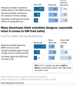
Despite the majority of Americans trusting medical doctors as experts on health-realted issues, the same cannot be extended for environmental scientists and their
and environmental knowledge that has persisted for decades (Funk, 2017; Lazard and Atkinson, 2014). Part of this disconnect between institutional and public understanding can be attributed to the failure to contextualize environmental issues and research in an accessible way, such as by utilizing lay language, appealing graphics, and social media sharing (Lazard and Atkinson, 2014).
Figure 1 Significantly fewer Americans trust scientific understanding of climate science and genetically modified food safety than medical understanding. Source: Pew Research Center
the public both benefit from the global reach capabilities of web-based platforms, enabling a two-way conversation that broadens concern for scientific issues while
simultaneously allowing the public to contribute and challenge research ideas in real time (Luzón, 2013).
Science blogs can accommodate different audiences with different science information needs, ranging from researchers to curious citizens (Luzón, 2013).
Information on environmental protection and natural resources is generally insufficient, unclear, and incomplete among the public, so keeping regularly updated web pages and circulating links through social media incites interest and reach to an audience that may not otherwise encounter scientific information (Gravina, 2017). In one climate
communication project, a study found that continually publishing new case studies and blog posts resulted in steadily increasing viewership of the online project as it gained more popularity and traction (Newell and Dale, 2015). This result is contradictory to the assumption that viewership peaks immediately after the initial release of a new post, indicating that establishing an online presence creates “brand loyalty” and trust among users and greater use of online research materials (Newell and Dale, 2015). Continuing to maintain a dynamic web presence and producing new, creative media even after a
research project has concluded also builds online brand loyalty, engages audiences, and mobilizes the dissimination of research (Newell and Dale, 2015).
environmental action, but infographics can go even further (Lazard and Atkinson, 2014). One study comparing the effectiveness of infographics to simple visuals or text-based content found that infographics grabbed attention and conveyed information and emotion faster among study participants no matter their preference for either visual or verbal learning methods (Lazard and Atkinson, 2014). Infographics bypass technical, entangling language that could prevent readers from engaging with the content and are more likely to be shared and forwarded, making them a powerful science communication tool (Lazard and Atkinson, 2014). Adding a visual with a clear message and a pleasing aesthetic to a social media post increases viewership no matter the topic of the content (Newell and Dale, 2015).
Web design plays a role in inviting users into the conversation, especially when utilizing symbolic images, warm colors, and open layouts. These design choices convey a more equitable discourse, far removed from the traditional power dynamic of
authoritative, formal institutions in control of the flow of knowledge (Zhanga et al., 2015). Even small changes in design, like using a different font or color, can heighten emotional and persuasive power of messages, especially for political messages (Lazard and Atkinson, 2014). Utilizing design aesthetics to create a recognizable online brand for a science communication project also positively influences a website’s popularity and therefore increases the engagement of the research materials published on that website (Newell and Dale, 2015).
Incorportating interactive features into online content ensures greated
interactive design is not enough — a strong foundation and message in the written content is essential for interactivity to contribute any additional communication benefits with one study finding that both text-based and interactive arguments both increased support in participants by 36 percent, but interactive methods had a higher overall support rate for a NASA telescope project (Weber et al., 2016). Overall, though, simply
connecting participants with information about the project in any form — whether text or interactive — were more than 80 percent likely to support the telescope over the 64.5 percent of the control group with less than 12 percent undecided compared with 25 percent of the control group (Weber et al., 2016).
article or blog post, which picks out one data point out of thousands to feature, risking the addition of “sparkle appliqued to the surface” of science rather than a useful explanation or insight (Muurlink and Mcallister, 2015). Overall, using narrative helps audiences engage more readily with science, but often misrepresents or misconstrues the truth about scientific discovery (Muurlink and Mcallister, 2015). Online homogenous user
communities can feed into misinformation as well (Gravina, 2017). Science writers employing narrative storytelling elements must be aware of these hazards to balance the reader’s interest and the integrity of the research they report on.
Comment-enabled blogs facilitate discussion between researcher and reader, which contrasts with science’s traditional static representation in the media (Blanchard, 2011). Scientists who use web-based communication platforms like blogs convey their passion and expertise for their research subject, rectify the unsatisfactory way science is portrayed in the media, and increase transparency in research in a way traditional media cannot (Blanchard, 2011). The increased visibility that comes with science blogging also instills interdisciplinary collaboration and networking opportunities, allowing researchers to work together to connect to new audiences while improving their own research
(Bowman et al., 2015).
and scope of science topics. For example, the U.S. Department of Energy utilizes jargon and appeals to authority on their web pages to persuade the public to support carbon capture and storage technology (CCS) as a solution to climate change. Presenting content in this way asserts the agency’s credibility, but the technical language of the content requires users to already be knowledgeable in energy technology and therefore fails to engage and their persuade the public to support CCS in an optimal way (Feldpausch-Parker and Peterson, 2014).
While web-based communication platforms have been lauded for their
accessibility, timeliness, discourse, and reach, there are few studies on the effectiveness of websites as a science communication tool. There is an abundance of information about the dissemination of scientific information through social media, but relatively little on the design, content, and organization of research-based websites and their success in translating scientific knowledge from official institutions to the general public. Studies evaluating one specific element of online multimedia projects, such as the role of interactivity or narrative storytelling, do exist, but there are few examining the
also conducted prior to five years ago, which offers limited insight into such a dynamic Internet culture where trends rise and fall on a daily basis on the user side of science communication and frequent updates to coding languages shift the content creator side of science communication. Just as creating real environmental change and climate change action will take the interdisciplinary, coordinated efforts of countless researchers,
journalists, public information officiers, grassroots organizers, and policy makers, finding the most effective science communication methods will take more purposeful study, input, and conversation between all sides of academia and the media.
Methods
Articles
While conducting the literature review on websites as science communication tools, I read discussions on the place of narrative storytelling in science writing. Some authors argued that narrative inherently attributes characteristics to science that misconstrues and romanticizes the research process, forcing it into a neat, satisfying beginning, middle, and end format. With these cautions in mind, I decided to continue my plan to incorporate narrative elements into my seven 700- to 1500-word feature articles, organizing them based on the historical chronology of the Pappy’s Lane shipwreck and the development of the Outer Banks.
Reporting
accurately present the research without sacrificing my storytelling. This approach translated into adopting reporting standards used at most media publications, such as having a minimum of three sources for each article, which includes personal interviews, phone interviews, journal articles, reports, books, government documents, and my own personal observations. My committee provided some sources, such as Dr. Nathan Richards’ final report on the Pappy’s Lane wreck, scientific journal articles, creative nonfiction on Outer Banks culture, and contact information to experts. I also found my own sources through online research, government documents, email inquiries, and phone interviews, adding more as my reporting progressed for each article.
For interviews, I completed background research on both the topic and professional careers and expertise of my sources, preparing questions based on that research and my initial angle for an article. I recorded and took notes for all interviews and added to my list of prepared questions as I listened to my sources speak and revealed new information. I asked mostly open-ended questions, which usually reveal more information than a simple “yes or no” question and uncover a facet of the topic I did not know to look for prior.
open to uncovering new, more interesting information without bias for only telling the story I initially set out to write.
Writing
In my article writing, I adhered to a magazine feature format in terms of style and organization, including narrative and nonfiction essay elements to engage readers in my storytelling. I began with a hook to engage the reader before stating the purpose of the article and explaining any research or historical concepts in depth, ending with a memorable image, quote, or revelation. I maintained word choices accessible for a lay audience and limited long clauses and sentences, but allowed for some creativity and novelty in my diction to distinguish it from a straight news story and to keep readers interested in the less significant material. I limited complex, lengthy phrases and sentences and used brief, succinct paragraphs. I also adhered to the Associate Press Stylebook for consistency in word choice, spelling, grammar, and formatting conventions throughout the seven articles.
Overall, most of the prose was previously unpublished, but some sentences and paragraphs from my CSI blog posts were used in the new articles.
Limitations
As with all journalism publications, the amount of time allotted for reporting, my connections to experts, my individual expertise, and the attention span of the average reader limit the comprehensiveness of my articles. Given more of all of these elements, I could take a deeper dive into each topic with more extensive reporting, a longer word count, and more engaging prose.
Website
When designing the website and interactive contact, my findings from the
literature review reminded me to not make something interactive for the sake of novelty. Instead I made design choices to enhance user experience and meaningfully contribute to the persuasiveness and appeal of my written content and story structure.
Design Process
However, as the articles came together, sorting them into these sections proved too restricting for the narrative I wanted to tell, prompting a streamlined redesign.
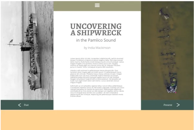
Figure 2 Initial website color composite layout created in Adobe XD. A complete evolution in the design can be found in the appendix.
In the redesign, I maintained the simple, clean aesthetic I originally created, retaining the same font choices and colors. As I designed, I looked at the article pages of media publication websites such as National Geographic and The Washington Post to determine what kinds of layouts, fonts, colors, and design hierarchy they used to make their content readable yet a distinct and recognizable brand. I chose earthy colors,
the historical nature of the Pappy’s Lane shipwreck project while choosing a clean sans-serif body copy font to make the articles readable.
Although my initial design divided the articles in shorter, less intimidating, more easily digestible sections, the reality is that I had overdesigned and over-organized for the amount of content I was producing. I ultimately decided to streamline the navigation into one gradient on one central page without the distinction of Past, Present, or Future,
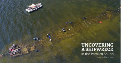
Figure 3 A color composite layout of the final website design made in Adobe XD. The complete evolution of the design can be viewed in the appendix.
Coding
To build the website, I used the code editor Atom and the coding languages HTML, CSS, and Javascript.
While today’s potential for online interactive design is essentially infinite, my own coding skills are limited to front-end development and basic JavaScript, which excludes the powerful data-driven documents JavaScript library. Because of this, I designed the website with simple functionality in mind.
The written content was also not data-based, so there were not as many
opportunities to create interactive visualizations, such as charts and graphs, as I originally predicated.
Articles
Following are the feature articles published on the website, in order.
Article 1: Prelude to Identification
On a calm day in Rodanthe, North Carolina, the stern of the Pappy’s Lane shipwreck is visible from the shore. Since it ran aground on the shallow bottom of the Pamlico Sound in the 1960s, it’s transformed from ship to kite surfing obstacle. A red flag marks its place for the rough days when water rises and overtakes it again.
As the years, hurricanes and tourists pass through Hatteras Island, the shipwreck has scattered into fragments. The wind and brackish water stripped its deck away, leaving less than 15 percent of its structure. It faded from the island’s memory even faster.
Hatteras Island villages have a deep sense of history. But when it comes to the story of Pappy’s Lane wreck, no one remembers anything.
"It's kind of like a car parked on the side of the road,” said Nathan Richards, director of maritime studies at East Carolina University. “When was it parked there? People forget.” Richards has periodically researched the wreck since 2010, but besides the kite surfers dodging its oyster-encrusted frame and a mark on a laminated paper map in the tower of the nearby historic Chicamacomico lifesaving station, he found little tangible acknowledgement of the wreck on the island.
But then the North Carolina Department of Transportation proposed an extension of the Bonner Bridge — the only drivable route linking Hatteras Island to the rest of the state — its steel pillars planned within 100 meters of the wreck. With the ship’s identity unknown, the bridge threatened to damage what could be a site of historical and cultural significance.
To minimize the impact of the bridge’s construction, a complete assessment of the wreck was warranted, according to N.C. DOT documents. The assessment, headed by Richards, represented a collision of history and future development. This ship, lying disregarded half in the sound, half in the sun, had a story to tell. One that could impact the infrastructure on an island with its only road frequently cut off by ocean overwash.
With the assistance of the N.C. DOT, the Pappy’s Lane Shipwreck Project began in the summer of 2017 as Richards completed historical research. After examining maps and photographs of the wreck, he turned up a likely candidate, a 19th century vessel.
loaded wetsuits, oxygen tanks, scuba masks, buckets, tape measures, diving slates and translucent mylar sheets into trucks. Each morning during the 40-minute drive from the Coastal Studies Institute in Wanchese to Rodanthe, they towed their gear and boats across the Bonner Bridge onto Hatteras Island. The bridge’s replacement ran beside them, interrupting their view of the Pamlico Sound as construction cranes and boats did their work.
In Rodanthe, they put their boats in and rode to the wreck a hundred yards off shore. Working in chest-high water, some students strapped on scuba gear to dredge the submerged hull while some stuck with snorkel gear to drawing features of the ship onto the mylar sheets. An interdisciplinary project, microbiologists sometimes joined them to study the microbial communities making their home on the ship, investigating their role in eating the vessel away.
It was a tricky ship to study. With the vessel half underwater, both archeologists and microbiologists developed multiple methods for research above and below the water. Even for the outreach portion of the project, John McCord, the CSI director of outreach and education, came to the site prepared to photograph the researchers from three angles: in the water, on the surface and in the air. Underwater photography and drone footage not only connected the public with the project, but provided high-resolution aerial
shipwrecks with little historical record, but the Pappy’s Lane mystery was surprisingly difficult to crack.
“This one was just particularly infuriating because it's a ship that was lost not that long ago,” said Richards. “There's plenty of people still alive that were around when this thing met its end in one way or another, and no one really knew. They just knew and remembered it always just being there."
Steadily, Richards and his team gathered enough archeological evidence from the wreck to, despite so few initial leads, pin an identity to the discarded artifact, a mystery story written in the shallow waves finally solved.
What the weeks of diving, drawing and mapping ultimately revealed was a surprise to all: The Pappy’s Lane wreck was a World War II gunboat. One that found its way from the turbulence of the Pacific Ocean to its final resting place at the bottom of the shallow, murky Pamlico Sound, forgotten.
Article 2: The Art and Science of Maritime Archeology
It may not be surprising to find out that Hatteras Island — a tiny spit of land only a few hundred yards at its thinnest — was not always where it is today. At one point, the island resided 50 miles further out to sea. Since its formation, the wind and waves have washed sand over the beach and back into its marshes, pushing it slowly inland and keeping its head above the 1 foot of sea level rise per century since its formation over 3,500 years ago.
disintegrated oyster-encrusted mass of iron and little historical documentation offering clues, retracing what happened on that journey required a detective.
Our detective is Nathan Richards, the director of maritime studies at East Carolina University. An Australian-born and educated maritime archaeologist, Richards came to the Outer Banks an expert in the kind of detective work needed to uncover the wreck’s story. He specializes in identifying abandoned shipwrecks, which are particularly difficult to study.
“There's no fanfare associated with their loss,” Richards said. “When ships are discarded, people aren't pulling their hair out and yelling, ‘catch my baby’. There's not hundreds of thousands and millions of dollars at stake. People are throwing away what they think is trash.”
When owners discard ships like garbage on the side of the road, there’s usually little to no historical record of them doing so. That means there was no acknowledgement of when the Pappy’s Lane vessel wrecked in local newspapers or government documents. The wreck has even faded from the memories of Hatteras Island residents.
Historical research would be key in uncovering what the wreck was and how it got there, but with so few leads, Richards had to get his hands in the Pamlico Sound’s mucky sand and do what he does best — archeological research.
ultimately pin a conclusive identity and history to the wreck. They just had to be thorough enough to spot them.
Every workday, Richards and his students jumped into chest-high water with wetsuits, scuba masks, waterproof mylar sheets, pens and diving slates. They drew section by section of the site on the mylar sheets while snorkeling and carefully climbing over the oyster-encrusted ship. Within three weeks, they had dozens of drawings. That’s where the jigsaw puzzle of drafting a site map began.
The students first worked with a partner to align the sheets for their assigned section of the wreck, carefully taping them together to create a complete picture. Once every individual section had been put together, the real puzzle ― and sometimes debating ― started. In drafting shipwreck site maps, getting details drawn as accurately as possible is extremely important, so when two points don’t perfectly align along the edges of the mylar sheets, debate over whose data point is right can occur. While the process of aligning the mylar sheets was civil for this project, some of the graduate students have seen conflict arise from this process on past projects.
Once all the mylar sheets were aligned and taped down, the light table was turned on, draft paper was rolled out, and tracing was started. For the next couple of hours, six or seven students at a time leaned over the light table with a pencil in one hand and eraser in the other, lightly tracing the lines on the mylar sheets onto the gridded roll of paper.
paper towel to keep oils from their hands from getting onto the paper and smudging their work.
In the end, they stitched together and transposed 177 drawings onto a site map with a scale of 1 foot of the ship to every 1 inch on the map, a high resolution.
Unfortunately, a site map wasn’t enough to unmask the wreck’s identity, calling for a unique research opportunity — dredging, a method Richards hasn’t used in a decade. Because dredging uncovers more of the wreck, it is exposed to oxygen and other environmental forces that can lead to corrosion and degradation. Even if researchers rebury the exposed wreck, it may take time for anaerobic conditions to re-establish and stop oxidation, a process that causes the iron to rust and that destroys diagnostic information.
The process of dredging requires physical removal of some parts of the wreck to dig further. Because it causes damage, dredging is only undertaken to answer a specific research question and only when meticulous records of activities before and after excavation are made, allowing for later reconstruction. For this project, that research question is simple, yet has proven difficult to answer: What is this ship?
After properly anchoring the boat, which also served as the dredging platform, and rolling out the hoses, the research team was ready to jump in the water with scuba gear and turn on the pump. They stayed under the water fanning sediment to the dredge head and slowly moved down through layers of sediment and oyster shell, which
periodically stuck in the hose, until the hull was exposed. As the digging continued, they found their smoking gun.
“There was a moment in the field when we were about to excavate the stern when we realized what the stern was, which is this sort of flat-bottom tunnel stern,” said
Richards. “At that point it became clear that I had a variable that was really important.” “That's what led us to the Landing Craft Support/Landing Craft Infantry
identification."
Finally, the team had a lead on where the Pappy’s Lane got its start: a class of World War II gunboat.
Article 3: Shipwreck Preservation
Erin Field’s team smelled it too. As Field, a microbiologist at East Carolina University, and two graduate students drilled out pieces of the ship below the surface, they smelled oil. Once they took those pieces back to the lab to study the vessel’s
microbial communities, they found oil contaminating their samples. When she mentioned it to Nathan Richards, head of the archeology team, they discovered that both groups encountered that out-of-place smell.
“We both came to that conclusion two different ways and just happened to talk about it,” said Field. This small piece of evidence helped point Richards to a vessel in the historical record: a World War II gunboat turned fuel barge.
The field work, historical research and oil smell all lined up. Two names, the LCS-123 and the Hunt Bros. No. 10, finally found their way back to Pappy’s Lane. Mystery solved.
But Field wasn’t there to find the wreck’s identity. She and her graduate students, Cody Garrison and Kyra Price, were out on the vessel to study how microbes interact with the ship and possibly contribute to its deterioration, a process called biocorrosion.
It was a unique research opportunity. Plenty of light penetrated the shallow water submerging the vessel, so Field knew there’d be an abundance of life to study compared to deep-water wrecks. Most unique, though, was a permit to drill off samples of the ship.
They collected samples of black- and orange-colored metal, signs of biocorrosion, to take back to the lab. There, they scraped off the surface of the metal, where the
microbes lived. From there they grew what they wanted to study — iron-oxidizing bacteria. Iron-oxidizing bacteria use iron for energy and make the orange rust on the surface of the wreck.
Past studies have suggested they can colonize and encourage biocorrosion, but they’ve never been found attached to a shipwreck.
“We know they're in sediments, we know that they're in the water, but we've never shown that they're on shipwrecks,” said Field. “We wanted to quantify those and see if they were there.” Field and her team found them on all of their samples from all across the ship.
“It was really exciting because it was the first time that had been shown on a shipwreck," said Field. “There's not lots and lots of them all over the ship. But, just because they're not in high abundance doesn't mean they aren't important. So we think that they work with the rest of their community to have an effect on the fate of the ship. It's one more piece of the puzzle."
Understanding the vessel’s varied and specialized microbial communities is one step closer to saving it and others like it from biocorrosion. Only 10 to 15 percent of the Pappy’s Lane wreck remains. With that dissolution, we’ve lost pieces of its story and insights into history.
To develop new preservation methods, it’ll take understanding of how microbes, sediment, seawater and more interact with the ship and intersect with its structure. That means cooperation from chemists to biologists to archeologists to historians. “This is really interdisciplinary work, and I love it for that reason,” said Field.
Nathan Henry, an archaeologist, is part of that interdisciplinary work. As the lead conservator at the N.C. Department of Natural and Cultural Resources’ Underwater Archaeology Branch Preservation Lab, Henry spends his days monitoring the thousands of shipwrecks populating North Carolina’s creeks, rivers and coastline.
“We track the wrecks that are under the state’s ownership and protect them as best we can,” said Henry. Protecting the wrecks means issuing permits to construction sites, treasure hunters and research teams to document and excavate them in the least
destructive way possible.
In addition to issuing project permits, the preservation lab in Kure Beach, tucked in among the live oaks, has an ocean view, saltwater tanks full of Civil War relics and tables covered in muskets and cannon balls. With a little chemistry, Henry dries out and preserves the wooden and iron artifacts before sending them off to museums and
universities.
But it’s best to leave the state’s shipwrecks and their cargo — which range from Native American dugout canoes to World War II tankers — where they settled. The 5000 documented wrecks in North Carolina’s waters far outpaces the resources Henry has to properly preserve them if taken onto dry land, and there’s more discovered all the time.
While these small, local boats may not get as much attention as the famous warships beneath the ocean waves, they have just as much knowledge to offer to the people of North Carolina.
“These local-built boats are important, probably as much as or more important, at least to me, than the big blockade runners,” said Henry. “Every one of them is a little bit different, and I think the regional boat building traditions are important as anything in history.”
Even if the majority of these wrecks remain forever submerged, the details collected and recorded from them add a critical piece to North Carolina’s identity.
“There’s a lot to discover out there every time you find one more shipwreck,” said Henry. “I think it's important to document that as best you can and collect as much
information as you can.”
With thousands of vessels in the Graveyard of the Atlantic, documenting and preserving shipwrecks may save centuries of history from being eaten by microbes, fragmenting into the water and cementing into the dark, sulfurous marsh mud.
Article 4: From the Pacific to the Pamlico
In the spring of 1945, Marty Heffren, a crewman in the U.S. Navy, and the USS LCS(L)(3) 123 traveled a long ways together. Starting in San Diego, Heffren neatly recorded their progress into the Pacific Ocean in a diary, calculating the numbers pushing them into war.
“April 23, 1945 Underway as before. Traveled 2,210 miles, 300 left to go.”
“April 30, 1945 Underway as before. Set clocks back half hour making 15 hours ahead of East Coast.”
On May 10th, they sighted Okinawa. Heffren continued to punctuate the horrors of battle in his diary as steadily as he logged the miles left until he reached it.
“May 12, 1945 Ran into a storm and then in the worst of the storm we discovered a light shining off our starboard bow in a distance. It was a skunk (suicide boat) and it almost lured us to a reef. We only missed the reef by 10 furlough or so and if we would have hit there would have been no survivors in the rough sea.”
“May 15, 1945 Went on night patrol duty off Jap held southern tip of Okinawa. It's named Hellhole because of air raids suicide boats coming in every night. I hope it doesn't live up to its name . . .”
“May 27, 1945 At 0730 three Jap suicide planes attacked our patrol with very disastrous results both to them and to us . . . All of our guns opened fire and after being hit the plane tried to dive on the DD 515 Anthony but it just missed the bow. As it passed over the bow, the pilot dropped on the deck of the destroyer, dead. It's the first Jap plane that we actually claim as ours. We were the first ship in our group to shoot down a plane.”
Because of their widespread activity in their relatively short career, these small, flat-bottomed LCSs earned the nickname “Mighty Midgets.”
Meanwhile, nearly 8,000 miles away, life was evolving at a slower, steady pace. In 1944, the first road appeared on Hatteras Island, an event that had no bearing on Heffren and the LCS-123 amidst World War II, but put into motion what brought the 123 from Okinawa to Rodanthe and its life as the Pappy’s Lane shipwreck.
After the drop of atomic bombs on Hiroshima and Nagasaki, the LCSs were dispersed throughout the world. Beginning in 1946, 51 of the remaining vessels were stricken from the Navy Register and sold for scrap metal or to commercial fishing companies. In an attempt to bolster allied militaries destroyed in the war, many were transferred to foreign fleets, such as France, Vietnam and Japan. They served less than two years for the United States during World War II, but some spent over two decades in the South Vietnamese Navy, serving as its first real warships.
The LCS-123 was one of the first of its class sold to a private owner, bought by James L. Teagle of Hampton, Virginia in 1947. It came back to the east coast, home, without sustaining any casualties.
In Virginia, the LCS-123 became the Hunt Bros. No. 10, operating under W. P. Hunt Company, which bought it from Teagle. A Hunt family friend, skilled mechanic and jack of all trades, Teagle oversaw the conversion of the warship into a tank barge, pulling off the deck and putting in new bulkheads in the late 1940s.
Hunt recalled the discovery of something that should not have been there as workmen cut open the bulkhead: a room, welded shut, full of weapons.
“Someone made a big error,” said Nathan Richards, a maritime archaeologist and head of the Pappy’s Lane shipwreck project. “They had to call every part of the military. The military came out to seize the weapons that they didn't even want in the first place.”
Evidence of this conversion can be found on what’s left of the wreck today, helping Richards compare this historical account from W.P. Hunt II with archeological evidence and confirm that the wreck and the Hunt Bros. No. 10. are one in the same.
Once completed, the vessel operated under the direction of William Powhatan Hunt, Sr. and witnessed the decline of the maritime transportation industry and rise of roads and oil pipelines. Since 1960, the volume of cargo carried by domestic ships has declined 61 percent, according to the Congressional Research Service.
Hunt’s company underwent multiple evolutions in its last decade to stay afloat, finally becoming a seafood company before closing in 1988. In the midst of those
changes, the Hunt Bros. No. 10 once again fades into mystery, it’s last definitive entry in the historical record reading “out of documentation” in 1965.
It may have had one final life in service to Roanoke Island’s Daniels family, who may have it used to salvage barges, but without documentation, Richards is hesitant to say this was how it spent its final days, which may indefinitely remain a mystery.
Article 5: Island Adaptions
water stretching to the horizon that drew tens of thousands of tourists to Hatteras Island every year. But then she realized something scary.
The only thing keeping her and her two-year-old son in the backseat from falling into that water — the Bonner Bridge, which had just received a sufficiency rating of 2 out of 100 — could collapse under them.
“It just hit me,” said Kavanaugh. “What if this bridge actually had a problem while we were on it? What if by some miracle I got out? How on Earth would I get my child up?” At that time, the bridge built in 1963 had exceeded its lifespan by nearly two decades. Outer Banks residents had settled into keeping hammers in their cars or rolling down the windows while crossing the 2.5-mile-long bridge, the island’s only drivable route off or on.
But in February 2019, after a lengthy 30 years of public hearings and planning, a $250 million replacement opened to traffic. Not only does it mark an engineering feat over the shifting shoals and sands of Hatteras Island, it represents a new era of resiliency for the coastal community in the face of rising seas and powerful storms.
Island life has changed dramatically since the Pappy’s Lane served as a freshly-minted oceangoing warship in 1944. Since settling into place on the bottom of the Pamlico Sound in the 1960s, the wreck witnessed a quiet revolution from its post — road and bridge building. The construction of N.C. Highway 12 and the Bonner Bridge opened the island to the world. It was no longer a rural collection of fishing villages only
accessible by boat, but a major summer tourist destination.
“That investment in that bridge . . . may actually be leaning more towards the side of future development rather than conservation,” said Michael Flynn, a coastal advocate at the North Carolina Coastal Federation. “It seems to be a signal to investors that transportation to this property will be maintained the next 50 to a hundred years.”
It took the participation of several government agencies to design a bridge that not only will hold up over the next 100 years but will preserve an island perfect for both surfers and sea turtles. That meant hurdling over environmental regulations set by the island’s two largest property owners — the National Park Service and the U.S. Fish and Wildlife Service.
“We presented [the N.C. Department of Transportation] a lot of challenges in minimizing the impacts to the environment,” said Steve Thompson, the Park Service permit monitor. He worked with other agencies such as the Army Corp of Engineers and the N.C. DOT on over 30 drafts of the permit to balance conservation and maintaining access.
To also address the N.C. Highway 12 “hot spots” frequently cut off by ocean overwash, the N.C. DOT originally proposed a 17-mile long bridge from the inlet to Rodanthe. While the most environmentally sound, this option was too expensive and removed access to the Pea Island Wildlife Refuge.
Planners ultimately settled on a replacement just to the west of the existing bridge with separate bridges planned in Rodanthe and Pea Island. That Rodanthe bridge is where the forgotten Pappy’s Lane shipwreck comes in. Dubbed the “jug handle,” plans extend the road from the wildlife refuge out into the sound and then back onto shore in
Rodanthe, bypassing the hot spots — and putting steel pillars within 100 meters of the wreck. As part of the mitigation for these bridge projects, N.C. DOT funded the project to uncover its identity.
The wreck, a World War II gunboat, ultimately did not influence the proposed construction, but the Oregon Inlet’s powerful tides and unpredictable shoals presented their own engineering challenges.
“Fishermen drown near the inlet and boats break up, both of which I've seen,” said Thompson. “Those dynamics had to be carefully weighed about where the bridge was placed and how many spans it would have.”
Climate change forces will amplify those powerful dynamics. To maximize the bridge’s lifespan, planners used a 50-year forecast to predict how erosion will move the shoreline over the decades, said Smyre. With an added buffer on the worst-case scenario predictions, the new bridge is longer and taller than the old one.
No matter how sturdy the bridge or proactive the policy, the ocean will cut off N.C. Highway 12 again during a not-too-distant future storm, damaging homes and temporarily stranding Hatteras Islanders. But the harsh environment that makes
As one of the few, special places where residents introduce themselves with a handshake and the number of generations their family has lived there, names are as old and sacred as the legends of pirates and lost colonists. O’Neals, Barnetts, Rollinsons, Austins, Midgetts, Midgettes, Jennettes, Odens, Stowes, Burruss and Ballances have been there since their ancestors washed up on the shores of the Graveyard of the Atlantic. They built the island with what the sea took from others and gave to them, using washed up pieces of shipwrecks to building their homes and boats. The ocean’s spilled contents became the backbone of the old fishing villages.
And today, when tourists flee hurricanes and nor’ easters’, theses families stay, rebuild and adapt.
“This is an ever-changing environment,” said Kavanaugh. “We're going to have to adjust for the weather and erosion. It’s part of the life of life here.”
Those adjustments may be as simple as keeping a hammer in your car or as complicated as building a bridge on shifting sands, but whatever the challenges, the island’s natural beauty and sense of community make it worth it.
“We don't live off the map, but we do live near the ocean and you have to have a healthy respect,” said Thompson. “It's just for the joy of living on the ocean that the people are here.”
Article 6: Shipwreck Ecology: From Man’s Tragedy to Nature’s New
Home
in the lab. Sea grass blanketed the wreck, its removal eating up some good weather days. Oysters covering the wreck threatened to cut, or as project lead Nathan Richards
affectionately said, bite researchers if not properly covered with both wetsuits and work coveralls.
But these brushes with nature were more than annoyances. They symbolized the wreck’s transformation from discarded human-made artifact to integrated component of a thriving ecosystem.
This shipwreck is not the only one supporting marine organisms — and science — in its new life on the bottom. In the five years Paula Whitfield studied shipwrecks off of North Carolina’s coast, she encountered not only the wrecks’ rich history of tragedy and loss, but also a spectacular display of life. While scuba diving among the algae- and coral-covered World War II tankers and merchant ships, she swam with countless schooling fishes, manta rays, a whale shark and, once, 60 sand tiger sharks.
“It's kind of mind blowing at times,” said Whitfield, a National Oceanic and Atmospheric Association fisheries ecologist. “When I would dive in the Caribbean, I would continuously be disappointed, because I was always comparing it to what I would see off of North Carolina.”
over 51,000 jobs on shore, according to Oceana, an ocean conservation and advocacy organization.
The turbulent oceanic and atmospheric dynamics surrounding the interactions of these cold and warm water currents also gives North Carolina’s coast its centuries-old reputation for being the “Graveyard of the Atlantic.” There are over 5,000 documented shipwrecks in the state’s waters with countless more undiscovered, according to the N.C. Department of Natural and Cultural Resources Underwater Archaeology Branch.
These shipwrecks are more than popular diving spots — they represent research essential for monitoring change and managing the state’s valuable natural resources. The wrecks rising high into the water column seem to attract a greater wealth of marine species, from smaller fishes to megafauna like sand tiger sharks, compared to the flatter natural rock bottom.
“There's not maybe as much food, but a lot of fish, even in the deep sea, are attracted to structure,” said Steve Ross, a research professor at the University of North Carolina Wilmington Center for Marine Science. “Whether there's food there or not, they're attracted to any complex habitat.”
While there are no studies definitively suggesting that wrecks are an improved habitat over natural ones, some wrecks are better than others. Older wrecks generally have a higher cover of invertebrates, which attracts and supports more fishes, said Ross.
There’s also a significant contrast from warmer, lighter shallow-water wrecks to the colder, darker deep-water wrecks.
species in the deep sea than in the shallow waters. The whole community is a little bit more simplified.”
But that doesn’t mean deep water comes without beauty. On Ross’ research cruises, him and a team of up to 20 other scientists explore wrecks at the dark depths of 600 feet to 2.5 miles. With either submarines or remotely operated vehicles, they count and collect species, encountering swordfish, whales, sharks, and several-thousand-year-old deep-water corals as they do.
“I've seen some really beautiful scenes where you're surrounded by complete darkness except for the lights of the submarine,” said Ross. “You light up these coral reefs that just have tons of organisms feeding and food drifting through the water column. They’re as beautiful as shallow-water coral reefs.”
No matter the depth, shipwrecks simplify monitoring fish communities. Their recognizable 3-D structure makes them easy to get back to year after year and collect the consistent observations used to evaluate change. Because fish are attracted to them, scientists can also study a more concentrated, diverse group of species than the natural rock surface where they’re more spread out, said Whitfield.
The data collected includes the diversity of species, number of individuals, water conditions and time of year, which can be used to monitor the warming effects of climate change on our oceans. During her research, Whitfield saw more warm-water fish than she expected.
more tropical, we're going to be able to use those shipwrecks as signals of how the ecosystem is changing.”
The observations on shipwrecks also translate into the protection of vulnerable habitats. The South Atlantic Fishery Management Council has used Ross’s findings to designate “habitat areas of particular concern,” which stipulate where people can and cannot fish.
“A lot of the time, the scientific data is ignored in management,” said Ross. “We've been very fortunate in that the management community has used a lot of our data, so we've been very successful at getting deep-water habitats protected.”
Protecting North Carolina’s waters means preserving a remarkable habitat unlike any other in the North Atlantic Ocean. This scene of storms, shoals, war, terror and death where so many ships met their end harbors a significant biological resource beneath the waves.
“The fishermen who work off of Cape Hatteras refer to that place in the ocean where the currents meet as ‘The Point’,” said Larry Cahoon, a biological oceanographer and limnologist at the University of North Carolina Wilmington. “That area is really remarkable biologically.”
“As these activities move deeper, if we don't know what's there, we don't know whether to protect it or not,” said Ross. “In fact, if we don't know what's there, we don't even know if we've lost anything.”
Article 7: Climate Change and Coastal Infrastructure
Steve Thompson has become familiar with heartbreak in his 20 years on Hatteras Island. In such a dynamic and, at times, unforgiving environment, homes and businesses aren’t promised to stay on their foundation. Rain, flooding, wind and waves have been eating away both soundside marshes and oceanfront beaches, along with the structures that occupy them.
“I've watched homes start to kneel in the ocean edge,” said Thompson, a National Park Service permit monitor. “I mean literally start to lower themselves into the water on their foundation as it's washed away.”
He’s also heard harrowing stories of survival at the island’s most volatile. One friend and his wife stayed in Rodanthe during a hurricane to watch over their beautiful three-story home. Once night fell, the storm surge swallowed up the land and began flooding their house. They ended the night swimming for their lives to the nearest light in the dark after their home caught fire.
With climate change threatening to increase the intensity and frequency of what causes that heartbreak — storms and sea level rise — residents and property owners will have to reevaluate their relationship with the island’s natural elements.
infrastructure planning. To address erosion — which is up to 12 feet per year in some places — and ocean overwash, the N.C. Department of Transportation has invested in a new bridge in Rodanthe in addition to an overdue replacement for the Bonner Bridge.
These investments represent a commitment to maintain access to the island for the next 50 to 100 years, securing the survival of its tourism-based economy and the
longevity of its communities, said Michael Flynn, a coastal advocate at the North Carolina Coastal Federation.
But climate change adds in a new factor to consider. Sea levels are expected to rise one inch per year in the Southeast, according to a 2017 study published by the American Geophysical Union.
“The real concern with sea level rise is what that means for storm surge and extreme weather events,” said Aaron Strong, a sustainability scientist at Hamilton
College. “You add those extra few inches onto storm surge, and all of a sudden what used to be a once-in-a-generation storm becomes a one-every-few-years storm.”
To adapt, Strong said communities have three methods to consider: protection, accommodation and retreat.
Protection encompasses physical barriers and shoreline hardening, such as seawalls, to prevent flooding. It also includes beach nourishment projects, which pumps sand onto an eroding beach to widen it. Projects have been implemented throughout the Outer Banks, but with a 5-year lifespan, they’re only a temporary solution.
Accommodation includes zoning and land usage rules that allow and prepare for flooding. These rules are already in place in most coastal communities, said Spencer Rogers, a coastal engineering specialist with the North Carolina Sea Grant.
“The same adaptation actions that we need to be considering for [climate change] are often immediately driven by next year’s hurricane and storm surge,” said Rogers. “Not something that is in the distant future.”
Those adaptations include requiring homes to be raised above a certain elevation. Most requirements are based on a 100-year flooding risk, or a 1 percent chance a year the home will be flooded. While those are good annual odds, looking at the entire lifetime of a home is a different story, said Rogers.
“If you accumulate that 1 percent per year over 70 years, the risk of the building seeing a flood and getting wet is about 50 percent,” said Rogers. “That's a heads or tails 50-50 chance of the building getting wet if you build it into the middle of the standard.”
While 81 percent of the state’s coastal communities require at least a foot of elevation above the minimum standard, more can always be done, which will help residents with both short- and long-term hazards, according to a North Carolina Sea Grant survey.
But these investments in protecting structures could create more problems down the road. By encouraging further development in areas vulnerable to climate change, there’ll be more people with more to lose in a storm.
Island, with its villages full of residents whose family names populate the generations-old headstones in roadside cemeteries, could retreat ever be an option?
“Retreat is really hard,” said Strong. “Just as we've seen with Florence and with Harvey, people rebuild in those in the same places, even if they know they're going to get hit again, because it's their home.”
While all the climate forecasts and economic models may point to retreat being the most sensible option, they don’t consider a far stronger decision-making factor: sense of place, or the emotional relationship and identity associated with a location.
“Discounting sense of place and treating people like they're just numbers that can be moved around, that's tough,” said Strong.
People with a stake in a coastal town, whether emotional or financial, won’t pick up and leave. To save their homes and neighbors, communities are beginning to take the climate change threat seriously, something that was rare just a decade ago, said Strong.
“People are starting to stop debating whether or not climate change is real and instead debating about what to do about it,” said Strong. “They’re realizing climate change is not an environmental problem. It’s actually a local and municipal land use problem.”
Next, government decision-making will need to become more flexible and adaptive to meet the unpredictable climate challenges that will arise in the coming decades, which may be easier said than done.
“It’s a really long process, which is of course is time that we don't really have,” said Strong. “At the same time, I think there's this narrative that we we're doing nothing about climate change, and we should give up hope. It's simply not true. We're doing lots of things about it in lots of places.”
Coastal North Carolina is already stepping up. Dare and Currituck County will be updating their hazard mitigation plans, land use ordinances and building codes in the next year, said Flynn. At a state level, Governor Roy Cooper signed Executive Order No. 80 in October 2018, which commits to reducing greenhouse gas emissions to 40 percent below 2005 levels by 2025. It also stipulates the integration of climate adaptation and resiliency planning into policy, including the support of risk and vulnerability
assessments for any interested communities.
On Hatteras Island, a place where saltwater pools on Highway 12 during king tides, residents have a healthy respect for what the ocean can do and the natural resources it supports.
“People who live on the island are impacted by nature so much, enough to have an intimate relationship with it,” said Flynn. “They're very environmentally minded and conscious.”
and surf fishing. They understand the value of their expansive Pamlico Sound, home to blue crabs and shipwrecks. They understand the value of the Pea Island Wildlife Refuge, home to seabirds and some of Thompson’s best memories.
“When my family comes to visit, we all hop into car, take our binoculars, go down there in the morning and see the birds in the bright sunlight,” said Thompson. “It is a great recreational and educational place.”
That’s why they stay through the heartbreak.
Website
http://imackinson.com/honors_thesis
Discussion
As readers move through the website, they travel through the history of both the Pappy’s Lane shipwreck and Hatteras Island, exploring research concepts from maritime archaeology to microbiology to ecology along the way. The wreck’s story — including both its history and the research used to investigate it — serves as a through line among discussions on coastal communities and their interactions with their environment. As a manmade artifact, the wreck possesses a relatable, intriguing story, allowing an easy entry point into material about less accessible natural science research and applications.
transportation shaped the Outer Banks. In addition to uncovering that narrative of change, I highlighted the research investigating its mechanisms.
In creating my own website and producing my own content, I experimented in the use of multimedia websites in science communication, a method that delves into research in a way that journal articles and institutional content cannot. These print-based methods, while thorough and comprehensive, limit the creativity of researchers in communicating their hard work and knowledge. Using a website also increases the content’s accessibility. Anyone with the link and Internet connection can read the articles and then share them.
With constantly changing and improving digital technologies and social networks, researchers, journalists, and communicators have the means to innovate new, engaging, and persuasive ways to tell science stories in unrestricted formats — both technologically and institutionally. By self-publishing the content and website created in conjunction with this paper, I was not required to wait for a publication’s approval and thus retained my autonomy as a writer and accelerated the dissemination of information between
researchers and the public. I was also able to control how the narrative was presented through the website’s design. It presented the articles in a sequence that prompted users to explore from left to right, but still allowed for users to interact with it in a way that most interested them and allowed for more engagement with the inclusion of videos and photographs. Self-publication does, however, come with risks. Without institutional review and editing, there is more opportunity for factual errors to appear in my published content.
community’s archeological, historical, and natural resources, of which Hatteras Island has a special abundance of. It may also be viewed by other coastal communities facing similar challenges and foster the exchange of ideas. Due to the interdisciplinary nature of the science I reported, it may facilitate collaboration between researchers of different expertise while raising awareness of the value and importance of interdisciplinary research communication. The articles can also be edited and republished in other publications to expand the reach of the project. I may also implement a survey asking website users what they liked about the website, what they learned, and how they will use their new knowledge to improve the project and add to science communication literature.
In the future, I may also expand my literature review of the effectiveness of online multimedia as a science communication method. The lack of comprehensive research on the topic signals the need for more collaboration between academics and communicators to innovate effectively and swiftly.
Conclusion
More emphasis on research, innovation, and collaboration in science
communication is crucial. In my literature review, I found a little research analyzing the effectiveness of online media in an age of significant digital media innovation, signaling a huge hole in knowledge that needs to be filled. To fill that knowledge, we need
photographers, graphic designers, and reporters would result in a more comprehensive and creative product, highlighting the value in collaboration among these specialties. For my own personal growth, however, working in these areas through this project gave me a better understanding of how all the pieces of research and web development come
together in an effective way, which will be a useful perspective as I move forward as a science communicator. Even if I specialize in one field, such as reporting, I can better write articles that translate well into an interactive story.
A major theme I discovered while reporting for this paper is the essentiality of collaboration and communication to the success of the research process. The
interdisciplinary nature of the Pappy’s Lane shipwreck, with work completed in archeology, history, and microbiology, contributed to the success of the project. For example, the archaeology team smelled petroleum while doing their work and the
microbiology team found petroleum in the samples from the shipwreck. Those two teams talking to each other about their observations helped lead to the identification of the wreck as a tank barge. The outreach and education efforts of this project also promoted community engagement and brought in important contacts for the project that may not have been discovered otherwise. These are examples of the importance of frequent, open communication among researchers and with the community. It strengthens the research and helps it go further.
their own special interest and needs. In the end, after scrapping dozens of drafts, a solution that balanced the community’s economic needs and environmental preservation was approved. That lesson — listening to stakeholders and respecting and balancing their needs — can be applied to other issues on the island and, more broadly, environmental issues around the globe. We need to prioritize transparent, frequent communication among all stakeholders, whether it is a family that has been living on the island for generations rebuilding their home, the commercial fisherman struggling to support his family, or a National Park Service ranger patrolling the beach for sea turtle nests. In these issues, no one stakeholder should have a greater agency in deciding how the island should adapt and balance its environmental and economic interests than any other.
For these stakeholders to form educated opinions and take beneficial action in protecting the island’s resources, swift, clear communication of all the facts, from studies of submerged aquatic vegetation impacts to climate change forecasts to raw dollars gained and lost, is required. The outreach efforts of the Pappy’s Lane Shipwreck Project strived to meet these goals through investing in outreach and education products, such as blog posts, press releases, videos and public lectures. From my perspective, this was a successful communication effort.
It is time to instill a trust in science and research again, which means making it accessible through innovation in new communication methods. But most importantly, scientists need to listen to the needs of the community and incorporate them into research applications and solutions.
Blanchard A. Science blogs in research and popularization of science: why, how and for whom? Common Knowledge: The Challenge of Transdisciplinarity. 2011:219– 232.
Bowman SR, Bozich J. Internet-based platforms for science communication. Integrated Environmental Assessment and Management. 2015;11(3):516–518.
Cahoon, L. (2019, March 29). Phone interview.
Feldpausch-Parker, A. M., & Peterson, T. R. (2014). Communicating the Science behind Carbon Sequestration: A Case Study of US Department of Energy and Regional Partnership Websites. Environmental Communication,9(3), 326-345.
Field, E. (2019, Feb. 1). Phone interview.
Funk, C. (2017, December 08). Mixed Messages about Public Trust in Science. Retrieved from https://www.pewresearch.org/science/2017/12/08/mixed-messages-about- public-trust-in-science/
Gravina, T., Muselli, M., Ligrone, R., & Rutigliano, F. A. (2017). SUstaiNability: A science communication website on environmental research. Natural Hazards and Earth System Sciences, 17(8), 1437-1446.
Henry, N. (2019, March 25). Personal interview.
Iodhia S. Web based social and environmental communication in the Australian minerals industry: an application of media richness framework. Journal of Cleaner
Production. 2011;25:73–85.
Kavanagh, N. (2019, March 4). Phone interview.
Luzón, M. Public Communication of Science in Blogs. Written Communication. 2013;30(4):428–457.
Muurlink, O., & Mcallister, P. (2015). Narrative risks in science writing for the lay public. Journal of Science Communication,14(03). doi:10.22323/2.14030201 Newell, R., & Dale, A. (2015). Meeting the Climate Change Challenge (MC3): The Role
of the Internet in Climate Change Research Dissemination and Knowledge Mobilization. Environmental Communication,9(2), 208-227.
doi:10.1080/17524032.2014.993412.
Richards, N. (2017). Pappy Lane Shipwreck (PAS0001): Public Education and Outreach as a Part of Mitigation For TIP B-2500(Rep.). UNC Coastal Studies Institute &
East Carolina University.
Richards, N. (2019, Jan. 29). Phone interview. Rogers, S. (2019, March 5). Phone interview. Ross, S. (2019, March 29). Phone interview. Smyre, B. (2019, March 4). Phone interview. Strong, A. (2019, March 29). Phone interview.
Takeda, K., Earl, G., Frey, J., Keay, S., & Wade, A. (2013). Enhancing research publications using rich interactive narratives. Philosophical Transactions: Mathematical, Physical and Engineering Sciences, 371(1983), 1-10. Thompson, S. (2019, March 1). Phone interview.
Weber, R., Dinc, S., & Williams, M. (2016). Americans’ Support for NASA’s James Webb Space Telescope. Science Communication,38(5), 601-625.