CHAPTER 13. ZONING
SECTION 1300 TITLE, PURPOSE, SCOPE AND INTERPRETATION
1300.01 Title. This Chapter shall be known and may be referred to as the "Circle Pines Zoning Ordinance of 1988" and may also be cited as "the Zoning Chapter" or "this Chapter".
1300.02 Purpose. This Chapter is enacted to promote the public health, safety and general welfare of the City through the following:
a. encouraging the planned and orderly development of residential, commercial, industrial, recreational and public uses of land;
b. providing for the compatible integration of different land uses and the most appropriate uses of land;
c. conserving the natural beauty and environmental assets of the City;
d. facilitating the provision of water, utilities and sewage disposal to property;
e. protecting the City's population from fire and other matters relating to public safety;
f. maintaining to a reasonable extent property values; and g. providing for the administration of this Chapter and prescribing penalties for violation of its provisions.
1300.03 Scope. From and after May 23, 1988, the use of all land and all buildings erected, altered, enlarged or relocated and every use accessory thereto shall be in conformance with the provisions of this Chapter.
1300.04 Interpretation. The provisions of this Chapter shall be minimum requirements. Where the conditions imposed by any provision of this Chapter differ from those required by any other provision of this Code, or any other ordinance, the section of either ordinance or code that places the greater restrictions or higher standard shall prevail. Words or terms defined in this Chapter shall have the meanings assigned to them unless such meaning is clearly contrary to the intent of this Chapter. Words in the singular number include the plural and words in the plural include the singular. The present tense shall include
past and future tenses. The word shall is mandatory and the word "may", is permissive. Words in the masculine gender include the feminine and neuter.
1300.05 Zoning Districts. For the purpose of this Chapter, the City is hereby divided into zoning districts as follows:
R-A, Single Family Residential District R-1, Single Family Residential District R-2, Single Family Residential District R-3, Single Family Residential District R-4, Multiple Family Residential District C-1, Neighborhood Commercial District C-2, Shopping Center Commercial District C-3, Commercial Industrial District
MU, Mixed Use Development
1300.06 Official Zoning Map. The boundaries of the zoning districts established by this Chapter shall be set forth in the zoning map, which shall be known as and may be referred to as the "zoning Map of Circle Pines" and may also be cited as the "zoning map". The map and all notations, references and data shown on it are incorporated by reference into this Chapter and shall be as much a part of this Chapter as if it were fully prescribed herein. 1300.07 Illustrations. Illustration 1 through 8 which are found in Appendix C of this Code are hereby incorporated into this Chapter to assist as guides in understanding the matters depicted in the illustrations. In the event of any conflict between the illustrations and the written provisions of this Chapter, the written provisions shall control.
1300.08 Enforcement, Effect and Validity.
Subd. 1 Enforcement of Chapter. The City Administrator or authorized representative shall conduct and supervise the enforcement of this Chapter with the assistance of the City Attorney, building official, Police Department and other designated staff. Enforcement actions to be taken by the City staff shall be authorized by the City Administrator.
Subd. 2 Orders by the City. Prior to the institution pursuant of legal proceedings, the City Administrator may, by written order, suspend, revoke or modify any permit or authorization issued pursuant to this Chapter on information and belief that the permit has been issued in error on the basis of incorrect or inadequate information, or that the work is not being performed in compliance with this Chapter or with the provisions of any permit issued pursuant hereto. The City Administrator, in addition, may issue an order to the owner or occupant of any premises to cease and desist the use of such premises immediately, when such premises are being used in a manner creating substantial hazard to the public health, safety or welfare, or in violation of any permit issued pursuant hereto. The City Administrator shall have the power to prevent unlawful erection, construction, reconstruction, alteration, repair, conversion, maintenance, or use of lands or structures within the City and to restrain, correct or abate such violations, or to prevent the occupancy of buildings, structures or lands, or prevent any illegal act, conduct, business, or use on or about said
premises and may use the City Attorney, police and other personnel in accomplishing these duties.
SECTION 1305 - DEFINITIONS
1305.01 Definitions. For the purpose of this Chapter, certain terms and words are defined as follows:
Subd. 1 Accessory Building. An uninhabited subordinate building located on the same lot as the main building. The use of such building is clearly subordinate to that of the main building or to the use of the premises.
Subd. 2 Accessory Use. A use subordinate to the principal use on the same premises and customarily incidental thereto.
Subd. 3 Apartment. A room or a suite of rooms within a building arranged, intended or designed for a place of residence.
Subd. 4 Applicant. Any person who wishes to obtain a building permit, zoning or subdivision approval.
Subd. 5 Basement. A basement is any floor level below the first story in a building, except that a floor level in a building having only one floor level shall be classified as a basement unless the distance from the floor level to the average grade level is less than the distance from the average grade level to the ceiling. A basement is a story for the purposes of height regulations if one-half or more of the basement height is above the average ground elevation.
Subd. 6 Bicycle. A vehicle with two wheels, one in front of the other and having a saddle like seat for the rider. It is steered by turning a handlebar and driven by chains and pedals or peddle-started.
Subd. 7 Billboards. A sign located on premises other than where the establishment, product, service or activity is located manufactured, sold, offered, displayed
or conducted.
Subd. 8 Block. A piece or parcel of land bounded by public highways, streets, streams, railway rights-of-way, exterior boundary or boundaries of a subdivision, un- subdivided acreage or parks, or a combination of thereof.
Subd. 9 Boathouse. A structure used solely for the storage of boats or boating equipment.
Subd. 10 Building. A structure having a roof supported by columns or walls and when separated by a division wall without opening, each portion of such building shall be deemed a separate building except as provided in the definition of apartment.
Subd. 11 Building Line. That line measured across the width of the lot at the point where the principal structure is placed in accordance with setback provisions.
Subd. 12 Building Official. The member or members of the City staff who enforce the City's Building Code.
Subd. 13 Building Permit. A license or instrument issued by the City to allow construction, alteration, or movement of a structure or building or part thereof.
Subd. 14 Clear-cutting. The removal of an entire stand of trees or natural vegetation.
Subd. 15 Cluster Development. Considered to be a type of Planned Unit Development or Community Unit Plan and is subject to the same criteria.
Subd. 16 Community Unit Plan (C.U.P.). A type of development which may incorporate a variety of land uses planned and developed as a unit. The Community Unit Plan is distinguished from the traditional subdivision process of development in that zoning standards such as density, height limits and minimum lot sizes may be altered by negotiation and agreement between the developer, the municipality and the Commissioner of Natural Resources.
Subd. 17 Comprehensive Plan. The official comprehensive municipal plan for guiding future physical, social and economical development of the City as required by the Metropolitan Planning Act.
Subd. 18 Detention Facility. A permanent natural or man-made structure, including wetlands, for the temporary storage of runoff which contains a permanent pool of water
Subd. 19 Display Window. A window in a business establishment used to display wares or services.
Subd. 20 Dwelling. A building or portion thereof, designed, occupied, or to be occupied exclusively for residential purposes, including one-family, two-one-family, and multiple dwellings, but not including
hotels and motels.
Subd. 21 Dwelling, Multiple Family. A building or portion thereof containing three (3) or more dwelling units.
Subd. 22 Dwelling, Single-family. A detached building arranged, intended or designed for occupancy by one family and used exclusively for occupancy by one family.
Subd. 23 Dwelling, Two-family. A building arranged, intended or designed for occupancy by two families and used exclusively for occupancy by two families living independently of each other.
Subd. 24 Dwelling Unit. One or more rooms which are connected together constituting complete, separate and independent living quarters, physically separated from any other room or dwelling unit which may be in the same building and containing permanent cooking, eating, sleeping and sanitary facilities for the exclusive use of a single family maintaining a household.
Subd. 25 Establishment. Any of the following definitions may apply: A distinct business entity located in a structure attached to other similar structures by common walls and ceilings or floors, or attached by means of an enclosed arcade; a distinct business entity contained within a single structure and not separated by walls or other physical barrier, but distinct because of its existence as a single lease space and operation by a separate entrepreneur, or by its singularity of purpose carried on by a single or separate proprietors.
Subd. 26 Expansion. An increase in the floor or land area or volume of an existing building.
Subd. 27 Family. An individual or one (1) or more persons related by blood, marriage or adoption including foster children, living together as a family unit.
Subd. 28 Fence. See Section 1315.08
Subd. 29 Finished Area. Completion of the interior area of a building to include taping, sheetrocking, electrical work and plumbing.
Subd. 30 Flood Fringe. The portion of the floodplain outside of the floodway.
Subd. 31 Flood Plain. The area subject to periodic inundation by a l00-year flood as designated on the official City flood plain map.
Subd. 32 Floodway. The channel of the
watercourse, the bed of water basins, and those portions of the adjoining floodplains that are reasonably required to
during a regional flood.
Subd. 33 Floor Area. The sum of the gross horizontal areas of the several floors of a building measured from the exterior faces of the exterior walls or from the center line of walls separating two buildings. The floor area of a building shall include basement floor area, penthouses, attic space having head room of 7 feet or more, interior balconies and mezzanines, enclosed porches and floor area devoted to accessory uses. However, any space devoted to mechanical equipment, stair wells, elevator shafts, parking or loading shall not be included in the floor area.
Subd. 34 Footing. That portion of the foundation of a structure which spreads and transmits bearing loads directly to the soil or pilings.
Subd. 35 Frontage. All the property lines abutting a street.
Subd. 36 Garage, Private. A building designed or used primarily for the storage or care of motor vehicles, including, but not limited to automobiles, pickup trucks and campers, owned and operated by residents of a principal structure on the same lot.
Subd. 37 Garage, Private-detached. A private garage that is entirely surrounded by open space on the same lot occupied by a dwelling unit.
Subd. 38 Garage, Public. Any premises, except those described as a private garage, used for the storage or care of self-propelled vehicles, or where any such vehicles are equipped for operation, repaired or kept for remuneration, hire or sale.
Subd. 39 Grade. An average level of the finished surface of the ground adjacent to the exterior walls of the building or structure or the degree of use or descent of a sloping surface, expressed in percentage terms.
Subd. 40 Height of Building. The vertical distance from grade plane to the average height of the highest roof surface.
Subd. 41 High Water Mark. See Ordinary High Water Mark. Subd. 42 Home Occupation. Any use conducted as an accessory use entirely within a dwelling by the occupants only.
Subd. 43 Hotel. Any building or portion thereof where lodging is offered to transient guests for compensation in
which there are more than five sleeping rooms with no cooking facilities in any individual room or apartment, and where access to individual rooms is provided through an indoor lobby or office.
Subd. 44 Hydric Soils. Soils that are saturated, flooded, or ponded long enough during the growing season to develop anaerobic conditions in the upper part.
Subd. 45 Hydrophytic Vegetation. Macrophytic plant life growing in water, soil or on a substrate that is at least periodically deficient in oxygen as a result of excessive water content.
Subd. 46 Junk Yard. An area, lot, parcel, building or structure or part thereof where used, waste, discarded or salvaged materials are bought, sold, exchanged, stored, abandoned, baled, cleaned, packed, disassembled or handled, including without limitation scrap iron and other metals, glass, paper, rags, rubber products, tires, bottles, building materials, vehicle parts, household appliances, brush and lumber. A junk yard includes an automobile wrecking or dismantling yard, but does not include accessory uses used in connection with a permitted manufacturing process when conducted within an enclosed area. The storage of unlicensed and/or inoperable motor vehicles for a period in excess of 30 days shall also be considered a junk yard.
Subd. 47 Kennel. Any establishment for the raising, training or boarding of dogs, cats or other small animals for hire or profit, or any establishment or residence, other than a pet shop or animal hospital, where more than three dogs or cats are harbored or kept.
Subd. 48 Land Disturbing or Development Activities. Any change of the land surface including removing vegetative cover, excavating, filling, grading, and the construction of any structure.
Subd. 49 Licensed Liquor Establishment. An
establishment that is licensed for on-sale liquor and 30% or more of its gross sales are derived from the serving of food, prepared and consumed on the premises. Where meals are
regularly prepared on the premises, has a seating capacity of at least 30 guests, where full waitress/waiter table service is provided, where a customer orders food from printed menus and where the main food course is served and consumed while seated at a single location. A licensed liquor establishment must also have at a minimum 25 different food items on the menu.
which has been established by plat, metes and bounds subdivision, or as otherwise permitted by law, and which is occupied by or intended to be developed for and occupied by a principal building or group of buildings and accessory buildings, or utilized for a principal use and uses accessory thereto, including such open spaces and yards as are designed and arranged or required by this Chapter for such building, use or development.
Subd. 51 Lot Area. The area of a horizontal plane bounded by the front, side and rear lot lines.
Subd. 52 Lot, Corner. A lot abutting upon two (2) or more streets at their intersections. A corner lot shall be deemed to front on that street on which it has its least dimension with the exception when the street address is on the side having the largest dimension, the street address side will be considered the front yard.
Subd. 53 Lot, Coverage. That portion of a lot covered by buildings, driveways, parking areas and any other impervious surface.
Subd. 54 Lot of Record. Any legally recorded lot which at the time of its recording complied with all applicable laws and ordinances.
Subd. 55 Lot, Interior. A lot other than a corner lot. Subd. 56 Lot, Through. An interior lot having frontage on two (2) parallel streets.
Subd. 57 Motel. A commercial establishment providing transient accommodations to the general public containing rooms having direct access to the outside without the necessity of passing through the main lobby of the building.
Subd. 58 Ordinary High Water Mark. A mark delineating the highest water level which has been maintained for a sufficient period of time to leave evidence upon the landscape. The ordinary high water mark is commonly that point where the natural vegetation changes from predominantly aquatic to predominantly terrestrial.
Subd. 59 Person. Any Individual, firm, corporation, partnership, franchise, association, or governmental entity.
Subd. 60 Planned Unit Development. (see Community Unit Plan).
Subd. 61 Premises. A lot together with all of the buildings and structures located on it.
Subd. 62 Private Residential Swimming Pool. A swimming pool located within a residential district on private property, under the control of the owner, and intended to be an accessory use to a single-family dwelling for the use and enjoyment of the owner, the members of his family or invited guests, and for the use of which no charge or fee is imposed.
Subd. 63 Public Waters. Waters of the state as
defined in Minnesota Statutes, section 103G.005, subdivision 15.
Subd. 64 Regional Flood. A flood that is representative of large floods known to have occurred
generally in the state and reasonably characteristic of what can be expected to occur on an average frequency in the
magnitude of a 100-year recurrence interval.
Subd. 65 Restaurant. An eating facility, under the control of a single proprietor or manager, where meals are regularly prepared on the premises, has a seating capacity of at least 30 guests, where full waitress/waiter table service is provided, where a customer orders food from printed menus and where the main food course is served and consumed while seated at a single location, and where 60% or more of its gross sales are derived from the serving of food, prepared and consumed on the premises. An establishment must also have a minimum of 25 different food items on the menu.
Subd. 66 Retention Facility. A permanent natural or man made structure that provides for the storage of storm water runoff by means of a permanent pool of water.
Subd. 67 Roof Line. In structures with a flat roof, the top line of the coping; in structures with pitched roofs, the intersection of the outside wall with the roof.
Subd. 68 Satellite Dish Antenna. Any dish-shaped antenna designed to receive satellite signals for the purpose of television or radio reception or any other
similar type of communication.
Subd. 69 Sediment. Solid matter carried by water, sewage, or other liquids.
Subd. 70 Setback. The minimum horizontal distance between a structure or sanitary facility and the ordinary high water mark or between a structure or sanitary facility and a road, well, highway or property lines.
Subd. 71 Shorelands. Land located within the following distances from the ordinary high water mark of protected
ordinary high water mark of a lake, pond or flowage; and 2) land within three thousand (300) feet of a river or stream or the landward extent of a flood plain delineated by ordinance on such a river or stream, whichever is greater.
Subd. 72 Sign. See Section 1330.
Subd. 73 Story. That portion of a building included between the upper surface of any floor and the upper surface of the next floor above, except that the topmost story shall be that portion of a building included between the upper surface of the topmost floor and the ceiling or roof above. (Please see illustration #7)
Subd. 74 Street. A public right-of-way accepted or a private right-of-way approved pursuant to the requirements of the City, by public authority, which provides a legal primary means of public access to abutting property. The term street shall include a highway, thoroughfare, arterial, parkway, collector, avenue, drive, circle, road, boulevard or any other similar term describing an entity complying with the preceding requirements.
Subd. 75 Structure. Anything constructed or erected, which requires location on the ground, or attachment to something having a location on the ground. Structures include, but are not limited to, all buildings, bicycle and skateboard ramps, tree houses, swing sets, jungle gyms and any other device contemplated for more or less permanent location in or on a lot.
Subd. 76 Subdivision. The separation of an area, parcel or tract of land under single ownership into two or more parcels, tracts, lots or long-term leasehold interests where the creation of the leasehold interest necessitates the creation of streets, roads or alleys, for residential, commercial, industrial, or any other use or combination thereof, except those separations:
a. where all the resulting parcels, tracts, lots or interests will be 20 acres or larger in size and 500 feet in width for residential uses and 5 acres or larger in size for commercial and industrial uses;
b. creating cemetery lots; and
c. resulting from court orders, or the adjustment of a lot line by the relocation of a common boundary.
Subd. 77 Substandard Use. Any use of shorelands existing prior to May 23, 1988 which is permitted within the applicable zoning district but does not meet the minimum lot
area and length or water frontage, structure setbacks, or other dimensional standards of the Chapter.
Subd. 78 Swimming Pool. See Section 1335.
Subd. 79 Thoroughfare, Major. A collector street that carries traffic from one or more connecting streets.
Subd. 80 Use. The purpose for which land or premises or a building thereon is designed, arranged or intended, or for which it is or may be occupied or maintained.
Subd. 81 Uniform Building Code. The Uniform Building Code standards promulgated by the International Conference of Building officials, as adopted by this jurisdiction through the State Building Code.
Subd. 82 Yard. An open space on a lot which is free of buildings or structures
Subd. 83 Yard, Front. A yard extending across the full width of the lot and lying between the front line of the lot and the nearest line of any building extended to the side lot line nearest to that building.
Subd. 84 Yard, Rear. A yard extending across the full width of the lot and lying between the rear line of the lot and nearest line of any building extended to the side lot line nearest to that building.
Subd. 85 Yard, Side. A yard between the side line of the lot and nearest side line of any building and extending from the front property line to the rear property line.
Subd. 86 Wetlands. Lands transitional between terrestrial and aquatic systems where the water table is usually at or near the surface or the land is covered by
shallow water. For purposes of this definition, wetlands must have the following three attributes:
a) Have a predominance of hydric soils;
b) Are inundated or saturated by surface or ground water at a frequency and duration sufficient to support a prevalence of hydrophytic vegetation typically adapted for life in saturated soil conditions; and
c) Under normal circumstances support a prevalence of such vegetation.
SECTION 1310 - PERMITS, APPLICATION AND GENERAL REGULATIONS
1310.01 Building Permit Procedure.
Subd. 1 Necessity of Permit. Except for exempt work as defined in the State Building Code, no person shall erect, construct, alter, enlarge, repair, move or remove, any building or structure or part thereof without first securing a building permit.
Subd. 2 Application for Permit. An application for a building permit shall be made to the Building Official of the City on forms supplied by the City. When required by the Building Official, the application for a building permit shall be accompanied by two sets of a site plan meeting the requirements of Subsection 1310.02 of this Chapter.
Subd. 3 Issuance of Permit. No building permit shall be issued for activity in conflict with the provisions of this Chapter. The Building Official shall issue a building
permit only after determining that the application and plans comply with the provisions of this Chapter, the State Building Code, and other applicable laws and ordinances.
Subd. 4 Void Permit. If the work described in any building permit is not begun within 90 days or substantially completed within one year following the date of the issuance of the building permit, or such shorter time as is set forth in writing by the Building Official, the permit may become void at the discretion of the Building Official. Written notice that the permit is void shall be transmitted by the City to the permit holder, stating that activity authorized by the expired permit shall cease unless and until a new building permit has been obtained.
1310.02 Site Plan Review.
Subd. 1 Council Review. The Council, with the advice and recommendation of the Planning Commission, shall review and approve a site plan before issuance of a building permit in all C districts, in the R-4 district, the mixed-use district and when required by the City, in all cases where an application for a conditional use permit has been made.
Subd. 2 Necessary Material. The site plan shall be filed not less than three weeks in advance of the Planning Commission meeting at which it is to be considered. The site plan shall be accompanied by evidence of ownership or an interest in the property and any application fee, as set by the Council. The site plans shall be signed by a registered architect, civil engineer, landscape architect or other design professional, and shall include the information required by the City, which may include, without limitation, the following:
(a) Name of project.
(b) Name, address and telephone number of the applicant, engineer and owner of record.
(c) Legal description (certificate of survey may be required).
(d) Date proposed, north arrow, engineering scale, number of sheets and name of drawer.
(e) Vicinity map showing relationship of the proposed
development to surrounding streets, rights-of-way, easements and natural features.
(f) Description of intended use of the site, buildings and structures including type of occupancy and estimated occupancy load.
(g) Existing zoning land use. (h) Tabulation box indicating:
(1) Size of parcel in acres or square feet. (2) Gross floor area of each building.
(3) Percent of site covered by building.
(4) Percent of site covered by impervious surface. (5) Percent of site covered by parking area.
(6) Projected number of employees.
(7) Number of seats if intended use is a restaurant or place of assembly.
(8) Number of parking spaces required.
(9) Number of parking spaces provided including handicapped.
(10) Height of all buildings and structures and number of stories.
2. Site Plan.
(a) Property line dimensions, location of all existing and proposed structures with distances from boundaries, distance between structures, building dimensions and floor elevations.
(b) Grading and drainage plan showing existing natural features (topography, wetlands, vegetation, etc.) as well as proposed grade elevations and sedimentation and storm
(c) All existing and proposed points of egress/ingress showing widths at property lines, turning radii abutting rights-of-way with indicated center line, width, paving width, existing and proposed median cuts, and intersections of streets and driveways.
(d) Vehicular circulation system showing location and dimensions for all driveways, parking spaces, parking lot aisles, service roads, loading areas, fire lanes, emergency access (if necessary), public and private streets, alleys, sidewalks, bike paths, direction of traffic flow and traffic control devices.
(e) Landscaping plan.
(f) Location, access and screening detail of trash enclosures.
(g) Location and screening detail of roof top equipment.
(h) Location and detail of signage.
(i) Lighting location, style and mounting. (j) Building elevations from all directions.
(k) Utility plan identifying size and direction of existing water and sewer lines, fire hydrants, distance of hydrant to proposed building.
(1) List of proposed hazardous materials, use and storage.
(m) Proposed fire protection system.
Subd. 3 Review Procedure. The City Administrator shall assist the Planning Commission and the Council by reviewing all applications for site plan review in accordance with the standards contained in this Chapter. The City Administrator shall provide the Planning Commission and the Council with a report concerning each application for a site plan review. The Planning Commission shall, within 60 days after the submission of the application for site plan review, report its recommendation to the Council. A building permit may be issued if the proposed construction conforms to the site plan approval granted by the Council. A certificate of occupancy may be withheld if construction is not consistent with the terms of plan approval and will not be issued until the terms of plan approval are met.
Subd. 4 Site Plan Review Standards. The following standards shall be utilized in determining whether to approve a site plan. These standards are intended to provide a frame of reference for the applicant in the development of site plans as well as a method of review for the reviewing
authority. When in the judgment of the Planning Commission or Council the standards would create an unobtainable requirement they may then encourage creativity, invention and innovation in order to allow the unique circumstances of the site in question to be considered in furthering the general goals and intent of this Chapter.
1. Preservation of Landscape. The landscape shall be preserved in its natural state, insofar as practicable, by minimizing tree and soil removal, and any grade changes shall be in keeping with the general appearance of neighboring developed areas.
2. Relation of Proposed buildings to Environment. Proposed structures shall be related harmoniously to the terrain and to existing buildings in the vicinity that have a visual relationship to the proposed buildings. The achievement of such relationship may include the enclosure of space in conjunction with other existing buildings or other proposed buildings and their creation of focal points with respect to avenues of approach, terrain features or other buildings.
3. Drives, Parking and Circulation. With respect to vehicular and pedestrian circulation, including walkways, interior drives and parking, special attention shall be given to location and number of access points to the public streets, width of interior drives and access points, general interior circulation, separation of pedestrian and vehicular traffic and arrangement of parking areas that are safe and convenient and, insofar as practicable, that do not detract from the design of proposed buildings and structures and the neighboring properties.
4. Surface Water Drainage. Special attention shall be given to proper site surface drainage so that removal of surface waters will not adversely affect neighboring properties or the public storm drainage system. If practical, storm water shall be removed from all roofs, canopies and paved areas and carried away in an underground drainage system. Surface water in all paved areas shall be collected at intervals so that it will not obstruct the flow of vehicular or pedestrian traffic, and will not create puddles in the paved areas. Sites one acre or larger must meet Rice Creek Watershed District requirements.
5. Utility Service. Electric, cable and telephone distribution lines shall be placed underground where existing utility lines are underground. Any utility installations installed where lines are existing above ground shall be located so as to have a harmonious relation to the neighboring properties and the site.
structures or features shall be consistent with the requirements of Section 1330 of this Chapter.
7. Special Features. Exposed storage areas, refuse disposal, electrical transformers, exposed machinery installations, service areas, truck loading area, utility buildings and structures shall be subject to such setbacks, screen plantings or other screening methods as shall reasonably be required to prevent their being incongruous with the existing or contemplated environment and the surrounding properties.
8. On Site Lighting Requirements. On site lighting shall be in conformance with Section 1310.09, Subd. 2 of this Chapter.
1310.03 Board of Appeals and Adjustments.
Subd. 1 Creation and Membership. There is hereby created a Board of Appeals and Adjustments (the Board). The Planning Commission shall serve as the Board.
Subd. 2 Powers and Duties. The Board shall have the following powers:
1. To hear and decide appeals where it is alleged that there is an error in any order, requirement, decision or determination made by a member of the City staff in administration of this Chapter.
2. To hear requests for variances from the literal provisions of this Chapter.
3. To hear appeals pursuant to Minn. Stat. 462.359, Subd. 4.
Subd. 3 Advisory Rule. The decisions of the Board on matters within its jurisdiction are advisory to the Council.
Subd. 4 Variances. A variance may be requested only by the owner of the property to which the variance would apply, or his or her approved representative. A variance may not be granted which would allow the use of property in a manner not permitted within the applicable zoning district. In granting any variance, the Board may prescribe conditions to ensure substantial compliance with this Chapter, and to protect adjacent property. The violation of any written condition of a variance shall constitute a violation of this Chapter. A variance shall become void within one year following issuance unless substantial action has been taken by the petitioner in reliance thereon. A variance may be granted for an indefinite duration or for any specified duration. A variance may be granted by the Board and the Council only if the following requirements are met:
harmony with the general purpose and intent of city code and consistent with the comprehensive plan;
b. Variances may only be permitted when the applicant establishes that there are practical difficulties in complying with the zoning ordinance, meaning the property owner proposes to use the lot or parcel in a reasonable manner not permitted by the zoning code.
c. The plight of the property owner must be due to circumstances that are unique to the lot or parcel and is not created by the property owner.
d. The variances must not alter the essential character of the locality.
(e) That the variance will not alter the essential character of the City, will not be injurious to or adversely affect the health, safety or welfare of the residents of the City or the neighborhood in which the property is located and will be in keeping with the spirit and intent of this Chapter.
Subd. 5 Procedures.
(a) Form. Appeals and applications for variances shall be filed with the City Administrator on prescribed forms. Each application shall be accompanied by a fee, as established by the Council and, if required by the City, a registered survey of the land and buildings on the property to which the application relates. The application shall be completed in sufficient detail to clearly identify the variance applied for or the act appealed from and shall set forth the applicant's reasons why the application should be granted.
(b) Hearing. Upon the filing of an appeal or application for variance, the City Administrator shall set a time for a public hearing on the application before the Board. A notice of the time, place and purpose of the hearing shall be published in the official newspaper of the City at least 10 days prior to the day of the hearing. In addition, in the case of variance applications only, a similar notice shall be mailed at least 10 days before the day of hearing to each owner of affected property and property situated wholly or partly within 350 feet of the property to which the application relates. The applicant shall provide the names and addresses of all such owners.
(c) The Board shall keep a written record of all of its proceedings, including minutes of its meetings, its findings, and the actions taken on each matter heard by it, including the final recommendation. The Board may adopt such further rules for the conduct of its meetings
the dates of its meetings, the date by which applications must be filed to appear on the agenda of any particular meeting, provisions for the conduct of meetings, including the matter of giving oaths to witnesses at the hearings and the manner in which evidence may be presented, and provision for the filing of written briefs by the applicant or other interested parties. Any party may appear at a hearing in person or by his agent or attorney.
(d) Within a reasonable time following the hearing, the Board shall make its written recommendation and shall serve a copy of the same upon the applicant by depositing it in the United States Mail, postage prepaid, to the address of the applicant shown an the application. The recommendation of the Board shall also be reported to the Council. The Board shall report its findings with respect to the application and all facts in connection with it, and shall specifically and fully set forth any adjustment or variance and designate such conditions in connection therewith as will, in its opinion, secure substantially the objectives of the regulation or provision to which the adjustment or variance is granted.
(e) Upon receipt of such report, the Council shall by resolution approve and confirm the Board's recommendation with or without changes, whereupon the application may be approved, or shall refuse to approve or confirm the decision. In acting on the recommendation of the Board, the Council shall have all the powers of the Board, and may hold whatever public hearings it deems advisable.
1310.04 Conditional Use Permits.
Subd. 1 Permitted Uses. Conditional use permits may be issued for the following:
(a) Uses or purposes for which such permits are required by Subsections 1315.03, 1320.11, or any other provision of this Chapter.
(b) Commercial excavation in any district of natural materials used for building or construction purposes.
(c) Construction in any district of radio, citizen band, television or related towers.
Subd. 2 Application. Application for the issuance of a conditional use permit shall be made in writing to the City on forms provided by the City. Each application shall be accompanied by the payment of a fee as set from time to time by the Council, which fee shall be in addition to the required fee for the building permit application, if any. If required by the City, the application shall be accompanied by a site plan and supplementary graphic or written materials
which contain the information required by the City pursuant to Subsection 1310.02 of this Chapter.
Subd. 3 The applicant must demonstrate that the following with regard to the requested conditional use permit:
a.The use will not be injurious to the use and enjoyment of other property in the immediate vicinity for the purposes already permitted, nor substantially diminish and impair property values within the immediate
vicinity;
b.The establishment of the conditional use will not impede the normal and orderly development and
improvement of surrounding vacant property for uses allowed in the area;
c.Adequate utilities, access roads, drainage, and other necessary facilities have been or will be provided; d.The use is consistent with the purposes of the zone in
which the applicant intends to locate the proposed use;
e.The use is not in conflict with the comprehensive plan; and
f.The use is not detrimental to the protection of the general public health, safety and welfare.
Subd.4 Standards. The Planning Commission and the Council shall consider to what extent the applicant's plan minimizes possible adverse effects of the proposed conditional use and what modifications to the plan and what conditions on approval could further minimize the adverse effects of the proposed use. The following development standards shall be considered general requirements for conditional use permits except as hereinafter provided.
(a) The land area and setback requirements of the property containing such a use or activity meet the minimums established for the district.
(b) When abutting a residential use, the property shall be screened and landscaped.
(c) All city, county, state and federal laws, regulations and ordinances shall be complied with and all necessary permits secured.
(d) Signs shall not adversely impact adjoining or surrounding residential uses.
(e) Adequate off-road parking and loading shall be provided. Such parking and loading shall be screened and landscaped from abutting residential uses.
activity, and such use or activity shall not generate such additional extra traffic as to create a nuisance or hazard to existing traffic or surrounding land use.
(g) All access roads, driveways, parking areas and outside storage, service or sales areas shall be surfaced or grassed to control dust and drainage.
(h) All open and outdoor storage, sales and service areas shall be screened from view from public streets and from abutting residential uses or districts.
(i) All lighting shall be designed to prevent any direct source of light being visible from adjacent residential areas or from the public streets.
(j) The use or activity shall be properly drained to control surface water runoff.
(k) The architectural appearance and functional plan of the building and site shall not be so dissimilar to the existing buildings or area as to cause impairment in property values or constitute a blighting influence. (l) The proposed water, sewer and other utilities shall be capable of accommodating the proposed use.
(m) The performance standards set forth in Subsection 1310-09.
These standards shall be strictly applied unless the Council finds in the particular case that the community safety, health and welfare can as well or better be served by modifying them. Any special requirements applicable to the particular case which are imposed elsewhere in this Chapter shall be met in each case.
Subd. 5 Conditions. In reviewing applications for conditional use permits, the Planning Commission and the Council may attach reasonable conditions to mitigate anticipated adverse impacts associated with these uses, to protect the value of other property within the district, and to achieve the goals and objectives of the Comprehensive Plan. Such conditions may include, but are not limited to, the following:
(a) Controlling the number, area, bulk, height and location of such uses.
(b) Regulating ingress and egress to the property and the proposed structures thereon with particular reference to vehicle and pedestrian safety and convenience, traffic flow and control and access in case of fire or other catastrophe.
(c) Regulating off-street parking and loading areas where required.
(d) Utilities with reference to location availability and compatibility.
(e) Berming, fencing, screening, landscaping or other facilities to protect nearby property.
(f) Compatibility of appearance.
In determining such conditions, special consideration shall be given to protecting immediately adjacent properties from objectionable views, noise, traffic and other negative characteristics associated with such uses.
Subd. 6 Procedures. The Planning Commission shall hold a public hearing within 60 days of the date of filing of the application, or at the next regularly scheduled meeting thereafter. The City shall publish in its official newspaper notice of such hearing at least 10 days prior to the date of the hearing. In addition, a similar notice shall be mailed at least 10 days before the day of hearing to each owner of affected property and property situated wholly or partly within 350 feet of the property to which the application relates. The applicant shall provide the names and addresses of all such owners. Following the hearing, the Planning Commission shall submit its recommendation to the Council, which recommendation shall include all recommended conditions on the granting of the conditional use permit. The Council may hold whatever public hearings it deems advisable, or may return the application to the Planning Commission for further consideration. The Council may grant the application for the conditional use permit and may impose conditions additional to or different from those recommended by the Planning Commission. Applications for conditional use permits may be denied by resolution of the Council. The resolution denying the application shall state the reasons for denial, but may incorporate by reference the minutes and recommendations of the Planning Commission, staff reports, hearing testimony and other material relevant to the Councils decision.
Subd. 7 Termination. If compliance with all of the conditions of the conditional use permit have not taken place within the time prescribed by the Council, the permit is deemed terminated, unless the Council, in its sole discretion, extends the time for compliance for an additional period not to exceed one year. Any violation of a continuing condition shall be grounds for revocation of the conditional use permit, after notice of violation served upon the permit holder in the manner of a civil summons at least 10 days prior to hearing, and upon the Council finding at the revocation hearing that the condition violated remains necessary to carry out the purposes of this Section and that the permit holder is unable or unwilling to satisfy the condition. Such finding shall be made by majority vote, upon the preponderance of the evidence presented by the City staff and anyone appearing on behalf of the permit holder.
City Attorney, to guarantee performance of the conditions in any case where such performance is not otherwise guaranteed. Such security shall be provided prior to the issuance of building permits or initiation of work on the proposed improvements or development and shall be in an amount 1.25 times the approved estimated costs of labor and materials for the proposed improvements or development.
1310.05 Non-conforming Uses.
Subd. 1 Non-conforming Buildings and Uses. The existing use of a building or land lawful on May 10, 1988, may be continued, although such use does not conform with the provisions hereof. Except as hereinafter provided, non-conforming uses shall not be extended or enlarged.
Subd. 2 Discontinuance.
(a) If a non-conforming use of any building or premises is discontinued or its normal operation stopped for a period of one (1) year, the use of the same shall thereafter conform to the regulations of the district in which it is located.
(b) If the use of a non-conforming advertising sign structure is discontinued or its normal operation stopped for a period of six (6) months, said structure shall be removed.
Subd. 3 Alterations.
(a) If no structural alterations are made, a non- conforming use of a building may be changed to another non-conforming use of the same or more restricted intensity by conditional use permit. Whenever a non-conforming use of a building has been changed to a more restricted use or to a conforming use, such use shall not thereafter be changed into a less restricted one. For the purposes of this Chapter, a more restricted use or intensity means a use that qualifies as a permitted use in a more restrictive district than the use to which it is being compared. By way of illustration, the R-1 District is more restrictive than R-2, and C-1 is more restrictive than C-2.
(b) Structural alteration or addition to an existing house which is only in non-conformance due to having less than the required thirty foot front yard setback may make structural alterations or additions which are in compliance with this Chapter, provided the existing house is judged by the building official to be substantially in line with adjoining homes and the alteration or addition does not further reduce the front yard setback.
Subd. 4 Restoration. No non-conforming use, building or structure may be restored, except single-family dwellings in a residential district, which has been damaged by fire, explosion, flood, act of God or other calamity to the extent of more than fifty percent (50%) of its assessed market value if a building permit has not been applied for within 180 days of when the property is damaged.. A nonconforming use, building or structure which is damaged to a lesser degree may be restored and its previous use continued or resumed provided that restoration is completed within one (1) year following its damage and no enlargement occurs.
Subd. 5 Issued Permits. Nothing herein contained shall require any change in plans, construction or designated use of a building, or structure for which a building permit has been issued prior to May 10, 1988, provided, however, that the entire building shall be completed according to such plans as filed within twenty-four (24) months from the date of issuance of said permit or within such shorter time as required by the permit.
1310.06 Text Amendments and Zoning District Changes.
Subd. 1 Authority. The Council may from time to time by a majority vote the vote of all its members adopt amendments to Section 1300 through 1340 of this Chapter including the zoning map unless a two-thirds vote is required by Minnesota State Statues.
Subd. 2 Procedure.
(a) Proceedings to amend this Chapter shall only be initiated by the Council, the Planning commission or a petition of the property owner(s).
(b) An application for an amendment shall be filed with the City. Petitions by property owners requesting change in a district boundary shall be accompanied by a map or plat showing the lands proposed to be changed and all land within three hundred fifty (350) feet of the boundaries of the property proposed for such rezoning together with the names and addresses of the owners of lands in such area.
Subd. 3 Public Hearing. No amendment shall be adopted until a public hearing has been held thereon by the Planning Commission. Notice of the time, place and purpose of an amendment hearing shall be published in the official newspaper at least ten (10) days prior to the day of hearing. When an amendment involves changes in one or more district boundaries affecting an area of five (5) acres or less, notice of the hearing shall be mailed at least ten (10) days before the date of hearing to each owner of property within the area proposed to be changed and owners of property situated wholly or partially within three hundred fifty (350)
feet of the property to which the amendment relates. The failure of a property owner to receive notice as specified herein shall not invalidate the public hearing or the amendment proceeding. Where appropriate, notice shall also be given to affected homeowner's associations. If a development is proposed adjacent to a lake or will affect the usage of the lake, the applicant shall provide the City with a list of property owners abutting the lake at the time of application. The City shall provide mailed notice to the lake homeowners in compliance with the procedures above. The applicant is responsible for meeting with affected homeowners.
Subd. 4 Commission Action. Following conclusion of the public hearing held by the Planning Commission, the commission shall report its findings and recommendations on the proposed amendment to the Council. If no report is transmitted by the Planning commission within sixty (60) days following referral of the amendment to the Commission, the Council may take action on the amendment without awaiting the report.
Subd. 5 Council Action. Following Planning Commission consideration or the expiration of its review period, the Council may adopt the amendment or any part thereof in such form as it deems advisable, reject the amendment, or refer it to the Planning Commission for future consideration. 1310.07. Certificate of Occupancy.
Subd. 1 Certificate Required. It shall be unlawful to use, occupy, or permit the use or occupancy of any building or portion of building constructed, erected, enlarged, altered, converted or moved onto a lot within the City until a certificate of occupancy has been issued.
Subd. 2 Application. Application for a certificate of occupancy shall be made on forms provided by the City.
Subd. 3 Issuance. A certificate of occupancy shall be issued as soon as is practicable within 10 days of completion of the building, but only upon demonstration that the building and use are in conformance with all requirements of this Code and that all conditions of approval have been met. A record shall be kept of all certificates issued.
Subd. 4 Temporary Certificates. A temporary certificate of occupancy may be issued for a period not to exceed six months. Conditions may be imposed on the issuance of a temporary certificate of occupancy in order to ensure compliance with this Chapter including posting a bond or other financial security acceptable to the City. Issuance of a temporary certificate shall not alter the rights or obligations of the owner, tenant or City with respect to full compliance with the requirements of this chapter or other regulations of this Code.
Subd. 5 Revocation. A certificate of occupancy may be revoked if the building or use is no longer in compliance with the provisions of this Chapter. The City shall have authority to enforce the revocation of the certificate of occupancy by appropriate means. Upon revocation the building shall not be used for any purpose until issuance of a new certificate of occupancy.
1310.08 Prohibited Uses. No resident, industry, or business emitting foul odors, excessive smoke, vibration, noise or dust shall be deemed to be permitted.
1310.09 Performance Standards.
Subd. 1 Purpose. The purpose of performance standards is to establish specific and quantifiable limitations on identified types of pollution and other activities which have a high nuisance potential. The performance standards apply in all zoning districts unless specifically stated to the contrary.
Subd. 2 Exterior Lighting.
(a) Exterior lighting shall be designed and arranged to limit direct illumination and glare upon or into any contiguous parcel. Reflected glare or spill light shall not exceed five-tenths foot-candles as measured on the property line when abutting any residential parcel and one foot-candle on any abutting commercial or industrial parcel. Street lights installed in public right-of-way shall be excepted from these standards.
(b) Mitigative measures shall be employed to limit glare and spill light to protect neighboring parcels and to maintain traffic safety on public roads. These measures may include lenses, shields, louvers, prismatic control devices and limitations on the height and type of fixtures. The City may also limit the hours of operation of outdoor lighting if it is deemed necessary to reduce impacts on the surrounding neighborhood.
(c) No flickering or flashing lights shall be permitted.
(d) Direct, off-site views of the light source shall not be permitted except that globe and/or ornamental fixtures shall be approved only when the developer can demonstrate that off-site impacts stemming from direct views of the bulb are mitigated by the fixture design and/or location.
(e) The City may require submission of a light distribution plan if deemed necessary to ensure compliance with the intent of this Chapter.
(a) Noises emanating from any use shall be in compliance with and regulated by the standards of the Minnesota Pollution Control Agency. Any use established or remodeled after May 10, 1988 shall be so operated as to prevent vibration discernible at any point beyond the lot line of the site on which such use is located. The City may also limit the hours of operation of outdoor noise if it is deemed necessary to reduce impacts on the surrounding neighborhood.
(b) Ground vibration and noise caused by motor vehicles, trains, aircraft operations or temporary construction or demolition shall be exempt from these regulations. However, if deemed appropriate, the City may establish limits on the hours of operation of temporary construction or demolition operation to limit off-site impacts.
Subd. 4 Smoke and Particulate Matter. No use shall produce or emits Smoke, dust or particulate matter exceeding applicable regulations established by the Minnesota Pollution Control Agency.
Subd. 5 Odor. No use shall produce unreasonable or disturbing odors beyond the property line exceeding applicable regulations established by the Minnesota Pollution Control Agency.
Subd. 6 Toxic or Noxious Matter. No use or operation shall emit a concentration of toxic or noxious matter across the property line which exceeds applicable regulations of the Minnesota Pollution Control Agency.
Subd. 7 Radiation. No operations shall be conducted which exceed the standards established by applicable regulations of the Minnesota Department of Health.
Subd. 8 Heat and Humidity. No use shall produce any unreasonable, disturbing or unnecessary emissions of heat or humidity beyond the property line which cause material distress, discomfort or injury to persons of ordinary sensitivity.
Subd. 9 Electromagnetic Interference. No use shall produce electromagnetic interference with normal radio or television reception in any residential district or exceed applicable standards established by any applicable federal or state regulations.
Subd. 10 Fire and Explosive Hazards. All uses shall be subject to the fire prevention code of the City.
Subd. 11 Liquid or Solid Waste. All uses shall be subject to applicable regulations of the City and the Metropolitan Waste Control Commission governing discharge into a public storm or sanitary sewer, waterway or steam.
Subd. 12 Receive-only Satellite Dish Antennas and Other Antenna Devices. Receive-only satellite dishes and other antenna devices shall be subject to the following requirements:
(a) shall be in compliance with all City building and electrical code requirements;
(b) verification that the structural design has been approved by a professional engineer;
(c) verification that the mounting system and installation have been approved by a professional engineer;
(d) one per building or, if more than one antenna is proposed, the antennas shall be clustered in a single, screened location, or painted to blend in with an existing structure;
(e) submission of written authorization from the property owner;
(e) no advertising message shall be on the antenna structure;
(g) shall comply with setback requirements for principal structures and in no event shall be located between the principal structure and the front line; (h) shall be screened to the greatest extent practicable to minimize visual impacts on surrounding properties. Screening shall include landscape materials for ground mounted antennas and materials compatible with those utilized on the exterior of the building for roof mounted antennas;
(i) freestanding antennas located closer to a property line than the height of the antenna shall be designed and engineered to collapse progressively within the distance between the antenna and the property line;
(j) shall be in compliance with all applicable Federal Communications Commission (FCC) requirements; and
(k) antenna height shall be no more than 60’ as measured from the average ground elevation upon which it is located. Where antennas are located on existing structures they may exceed 60’ in height as long as they do not extend more than 20’ beyond the height of the existing structure.
1315.01 Intent.
a. Each of the residential districts is designed and intended to secure for the persons who reside there a comfortable, healthy, safe, and pleasant environment in which to live, sheltered from incompatible and disruptive activities that properly belong in non-residential districts.
b. The purpose of the R-A, R-1, R-2, and R-3 Districts is to provide for single family detached dwellings in those areas where such development is consistent with the low density residential designation of the comprehensive plan and compatible with surrounding land use characteristics.
c. The purpose of the R-4 District is to provide for attached dwelling units in those areas where such dwellings are consistent with the low or medium density residential designation of the comprehensive plan and compatible with the development pattern of the surrounding area.
d. Uses of land, buildings and structures not permitted below as either principal, accessory or conditional are prohibited. District regulations as set forth below shall also be subject to the other provisions of this Chapter.
1315.02 Table of Permitted Uses. The table of Permitted Uses below should be read in close conjunction with the definitions of terms set forth in Section 1305 and other interpretative provisions.
Districts
USE R-1 R-2 R-3 R-4 R-A
Single Family Dwelling x x x x x Two Family Dwelling x
Multi-family Dwelling x x
Churches & Hospitals x x x x x Parks & Playgrounds x x x x x (Recreational Areas)
Public Schools x x x x Fences as regulated in
1315.08 x x x x x
A state licensed resi- dential facility serving 6 or fewer persons, a lic- ensed day care facility
serving 12 or-fewer persons, or a group family day care facility licensed under Minnesota Rules to serve 14
or fewer children. x x x x x State licensed residential
facilities serving from 7 to
Districts
USE R-1 R-2 R-3 R-4 R-A
16 persons or a licensed day care facility serving
from 13 to 16 persons. x
Greenhouses with no on-prem-
ises sales x x x x x
Libraries, museums, schools and public owned and/or
controlled community, recreation
and memorial buildings include- ing name plates and bulletin boards placed in back of the prescribed setback lines, and accessory uses customary
thereto. x
Philanthropic and charitable
institutions x
Public utility buildings and facilities, excepting warehouses and storage yards, necessary to that area;
provided that such
utility structures conform to the architecture of the
buildings on the adjacent property. x Other uses customarily associ-
ated with, but subordinate to a
permitted use by the City. x x x x x ACCESSORY USES Accessory Buildings as regulated in Section 1315.07 x x x x x Private Garages x x x x x Signs as regulated in Section 1330 x x x x x
Home Occupations as
regulated in 1315.10 x x x x x Roadside stands for the
sale of garden products
produced on premises only x x x x x Keeping of not more than
two boarders and/or room-
ers by a resident family x x x x x Off-street parking as
regulated by 1315.06 x x x x x Satellite dish antennas
as regulated by 1310.10 Solar energy systems but not wind energy conversion
systems or windmills x x x x x
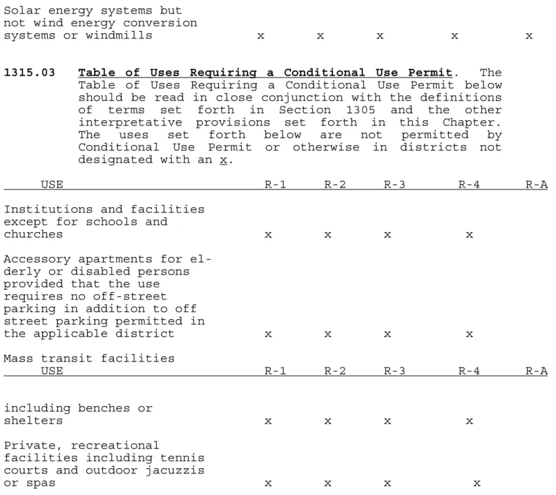
1315.03 Table of Uses Requiring a Conditional Use Permit. The Table of Uses Requiring a Conditional Use Permit below should be read in close conjunction with the definitions of terms set forth in Section 1305 and the other interpretative provisions set forth in this Chapter. The uses set forth below are not permitted by Conditional Use Permit or otherwise in districts not designated with an x.
USE R-1 R-2 R-3 R-4 R-A Institutions and facilities
except for schools and
churches x x x x
Accessory apartments for el- derly or disabled persons provided that the use requires no off-street parking in addition to off street parking permitted in
the applicable district x x x x Mass transit facilities
USE R-1 R-2 R-3 R-4 R-A
including benches or
shelters x x x x
Private, recreational
facilities including tennis courts and outdoor jacuzzis
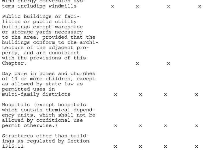
Wind energy conversion sys-
tems including windmills x x x x x Public buildings or faci-
lities or public utility buildings except warehouse or storage yards necessary to the area; provided that the buildings conform to the archi- tecture of the adjacent pro- perty, and are consistent with the provisions of this
Chapter. x x
Day care in homes and churches of 13 or more children, except as allowed by state law as permitted uses in
multi-family districts x x x x x Hospitals (except hospitals
which contain chemical depend- ency units, which shall not be allowed by conditional use
permit otherwise.) x x x x x Structures other than build-
ings as regulated by Section
1315.11 x x x x x
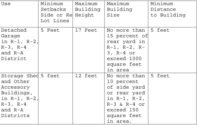
1315.04 Table of Minimum Lot Sizes and Setbacks.
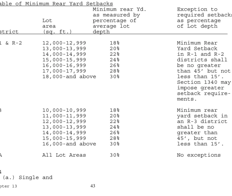
a. The Table of Minimum Lot Sizes and Setbacks for all residential districts should be read in close conjunction with the definitions of terms set forth in Section 1305.01 and the other interpretative provisions set forth in this section, and with the setback requirements of the Shoreland Overlay District. Refer to Section 1315.12 of this code for percentages of minimum rear yard setbacks.
Table of Minimum Lot Sizes and Setbacks.
District Lot Area
(Sq.Ft) Lot Width (Feet) Front Yard Setback (Feet) Rear Yard Setback (Feet) Side Yard Setback (Feet) Corner Setback (Feet) R-1 12,000/ Unit 80’ 30’ See Sect. 1315.12 10’ 15’ R-2 12,000/ Unit 80’ 30’ See Sect. 1315.12 10’ 15’ R-3 10,000/ 80’ 30’ See Sect.10’ 15’
R-A 1 Acre 140’ 30’ 30% 10’ 15’ R-4 (a) Single & Two Family Dwelling 7,000/ Unit 60’ 30’ See Sect. 1315.12 10’ 15’ R-4 (b) Multiple Family Dwelling 2,500/ Unit 60’ 30’ See Sect. 1315.12 10’ 15’ R-4 (c) Pine Hollow Development 5,400 Refer to Res. 04-17 12% of Length Of side yard 5’ 10’
(a.) Any institutional use or institutional building in any R District, other than a single family residence, shall not be located less than twenty-five (25) feet from any boundary line.
(b.) Any building other than a single-family residence shall not be located less than ten (10) feet from any boundary line of a lot used or intended for use as a residence.
Subd. 1 Permitted Encroachments. In residential districts and when attached to a dwelling, the following shall be permitted encroachments on the setback requirements that would otherwise apply:
(a) An Unenclosed Porch or an Enclosed Porch may encroach ten feet into a required front setback and five feet into a required side setback.
(b) For purposes of this subdivision, an “Unenclosed
Porch” means a horizontal roofed platform attached to a dwelling that also meets the following criteria. An unenclosed porch has a wall system that consists of roof support members, may have railings, and must not have doors, screens or windows.
(c) For purposes of this subdivision, an “Enclosed Porch” means a horizontal roofed platform attached to a
dwelling that also meets the following criteria.
Except for the side of the enclosed porch abutting the dwelling, the sides of an enclosed porch must be
consist of screens, windows, doors, or some combination thereof.
(d) In front yard steps, patio decks, terrace or similar features, provided they do not project more than ten (10) feet into the front yard and provided they do not extend above the height of the ground floor of the building.
(e) Chimneys, flues, belt courses, sills, cornices, buttresses, ornamental features, eaves or structures similar to all the foregoing provided they do not project more than two (2) feet.
(f) Wheelchair ramps are permitted encroachments in any yard as long as the ramp is located not less than one (1) foot from the front property line and not less than two (2) feet from the side and rear property line and is not located in an easement.
(g) Open fire escapes provided they do not project more than three and one-half (3 1/2) feet.
1315.05 Minimum Flooring and Maximum Building Heights for Residential Districts (See Illustration No. 7).
Subd. 1 Minimum Square Feet. Every lot developed for residential purposes shall have the minimum square feet per dwelling unit indicated in the following table. In determining the number of dwelling units permissible on a tract of land, fractions shall be rounded to the nearest whole number.
First Total Fl. Building
District Floor Area/Unit Height
(sq.ft.) (sq.ft.) (stories)
R-1
(a) One and one-half 1000 1300 35' story Dwelling
(b) Split Entry Dwelling No min. 1200 35’ (c) Split Level Dwelling No min. 1300 35’ (d) Other Dwellings 1200 1300 35’
R-A
(a) One and one-half 1000 1300 35’ story Dwelling