Release 2.10.4-0
GeoNetwork
1 Preface 3
1.1 About this Project . . . 3
1.2 License Information . . . 3
1.3 Author Information. . . 4
2 Quick Start Guide 5 2.1 Geographic Information Management for all . . . 5
2.2 Getting Started . . . 8
2.3 Viewing and Analysing the Data . . . 22
2.4 Adding a metadata record . . . 29
2.5 Uploading a New Record using the XML Metadata Insert Tool . . . 47
2.6 Metadata in Spatial Data Management. . . 48
2.7 New Features . . . 52
2.8 Installing the software . . . 56
2.9 Upgrading to a new Version . . . 64
3 Administration 65 3.1 System configuration . . . 65
3.2 Authentication . . . 75
3.3 OGC CSW server configuration . . . 81
3.4 Advanced configuration . . . 86
3.5 User and Group Administration . . . 101
3.6 Localization . . . 106
3.7 System Monitoring . . . 108
4 Managing Metadata 111 4.1 Templates. . . 111
4.2 Ownership and Privileges . . . 113
4.3 Import facilities . . . 116
4.4 Export facilities . . . 123
4.5 Status . . . 125
4.6 Versioning . . . 128
4.7 Harvesting . . . 134
4.8 Formatter . . . 188
4.9 Processing . . . 191
4.10 Fragments . . . 193
4.11 Schemas . . . 200
5 Features 203 5.1 Multilingual search. . . 203
5.2 Search Statistics . . . 208
5.3 Thesaurus. . . 210
5.4 User Self-Registration Functions . . . 222
6 Glossary of Metadata Fields Description 227 7 ISO Topic Categories 231 8 Free and Open Source Software for Geospatial Information Systems 235 8.1 Web Map Server software . . . 235
8.2 GIS Desktop software . . . 235
8.3 Web Map Viewer and Map Server Management . . . 235
9 Frequently Asked Questions 237 9.1 HTTP Status 400 Bad request . . . 237
9.2 Metadata insert fails . . . 237
9.3 Thumbnail insert fails . . . 237
9.4 The data/tmp directory . . . 238
9.5 What/Where is the GeoNetwork data directory?. . . 239
9.6 The base maps are not visible . . . 239
10 Glossary 241
Welcome to the GeoNetwork User Manual v2.10.4-0. The manual is a guide describing how to use the metadata catalog.
Other documents:
GeoNetwork Developer Manual GeoNetwork User Manual (PDF)
Preface
1.1 About this Project
This document provides guidelines to install, configure, use and customise the GeoNetwork opensource software.
The GeoNetwork project started out as a Spatial Data Catalogue System for the Food and Agriculture organisation of the United Nations (FAO), the United Nations World Food Programme (WFP) and the United Nations Environmental Programme (UNEP).
At present the project is widely used as the basis of Spatial Data Infrastructures all around the world. The project is part of the Open Source Geospatial Foundation (OSGeo) and can be found atGeoNetwork opensource.
1.2 License Information
1.2.1 Software
The GeoNetwork opensource software is released under theGPLv2 license and can be used and modi-fied free of charge.
1.2.2 Documentation
Documentation is released under aCreative Commonslicense with the following conditions.
You are free to Share (to copy, distribute and transmit) and to Remix (to adapt) the documentation under the following conditions:
GeoNetwork User Manual, Release 2.10.4-0
• Attribution. You must attribute GeoNetwork opensource documentation to GeoNetwork open-source developers.
• Share Alike. If you alter, transform, or build upon this work, you may distribute the resulting work only under the same or similar license to this one.
With the understanding that:
• Any of the above conditions can be waived if you get permission from the copyright holder. • Public Domain. Where the work or any of its elements is in the public domain under applicable
law, that status is in no way affected by the license.
Other Rights. In no way are any of the following rights affected by the license:
• Your fair dealing or fair use rights, or other applicable copyright exceptions and limitations; • The author’s moral rights;
• Rights other persons may have either in the work itself or in how the work is used, such as publicity or privacy rights.
Notice: For any reuse or distribution, you must make clear to others the license terms of this work. The best way to do this is with a link to this web page.
You may obtain a copy of the License atCreative Commons Attribution-ShareAlike 3.0 Unported Li-cense
The document is written in reStructuredText format for consistency and portability.
1.3 Author Information
The documentation was written by the GeoNetwork opensource Developers and other community members. The basis for the reStructuredText based documentation is based on the work done by the GeoServerproject and theSphinxframework.
If you have questions, found a bug or have enhancements, please contact us through the GeoNetwork opensource Development Mailing list [email protected]
Quick Start Guide
2.1 Geographic Information Management for all
2.1.1 Introduction
What is GeoNetwork opensource
GeoNetwork opensource is a standard based and decentralised spatial information management system, designed to enable access to geo-referenced databases and cartographic products from a variety of data providers through descriptive metadata, enhancing the spatial information exchange and sharing between organisations and their audience, using the capacities and the power of the Internet. The system provides a broad community of users with easy and timely access to available spatial data and thematic maps from multidisciplinary sources, that may in the end support informed decision making. The main goal of the software is to increase collaboration within and between organisations for reducing duplication and enhancing information consistency and quality and to improve the accessibility of a wide variety of geographic information along with the associated information, organised and documented in a standard and consistent way.
Main Features
• Instant search on local and distributed geospatial catalogues
• Uploading and downloading of data, documents, PDF’s and any other content
• An interactive Web map viewer that combines Web Map Services from distributed servers around the world
• Online map layout generation and export in PDF format • Online editing of metadata with a powerful template system
• Scheduled harvesting and synchronisation of metadata between distributed catalogues • Groups and users management
• Fine grained access control
GeoNetwork User Manual, Release 2.10.4-0
Background and evolution
The prototype of the GeoNetwork catalogue was developed by the Food and Agriculture organisation of the United Nations (FAO) in 2001 to systematically archive and publish the geographic datasets produced within the organisation. The prototype was built on experiences within and outside the or-ganisation. It used metadata content available from legacy systems that was transformed into what was then only a draft metadata standard, the ISO 19115. Later on, another UN agency, the World Food Programme (WFP) joined the project and with its contribution the first version of the software was re-leased in 2003 and operational catalogues were established in FAO and WFP. The system was based on the ISO19115:DIS metadata standard and embedded the Web Map Client InterMap that supported Open Geospatial Consortium (OGC) compliant Web Map Services. Distributed searches were possible using the standard Z39.50 catalogue protocol. At that moment it was decided to develop the program as a Free and Open Source Software to allow the whole geospatial users community to benefit from the development results and to contribute to the further advancement of the software.
Jointly with the UN Environmental Programme (UNEP), FAO developed a second version in 2004. The new release allowed users to work with multiple metadata standards (ISO 19115, FGDC and Dublin Core) in a transparent manner. It also allowed metadata to be shared between catalogues through a caching mechanism, improving reliability when searching in multiple catalogues.
In 2006, the GeoNetwork team dedicated efforts to develop a DVD containing the GeoNetwork version 2.0.3 and the best free and open source software in the field of Geoinformatics. The DVD was produced and distributed in hard copy to over three thousand people. More recently, the OSGeo Live project has been developed with GeoNetwork and all the best Open Source Geospatial software available on a self-contained bootable DVD, USB thumb drive or Virtual Machine based on Xubuntu. The GeoNetwork community has been a part of this project and will continue to make sure the latest stable version of GeoNetwork is included. You can download the OSGeo-Live images fromOSGeo Live website. GeoNetwork opensource is the result of the collaborative development of many contributors. These in-clude among others the Food and Agriculture organisation (FAO), the UN Office for the Coordination of Humanitarian Affairs (UNOCHA), the Consultative Group on International Agricultural Research (CSI-CGIAR), The UN Environmental Programme (UNEP), The European Space Agency (ESA) and many others. Support for the metadata standard ISO19115:2003 has been added by using the ISO19139:2007 implementation specification schema published in May 2007. The release also serves as the open source reference implementation of the OGC Catalogue Service for the Web (CSW 2.0.2) specification. Im-provements to give users a more responsive and interactive experience have been substantial and include a new Web map viewer and a complete revision of search interface.
The use of International Standards
GeoNetwork has been developed following the principles of a Free and Open Source Software (FOSS) and based on International and Open Standards for services and protocols, like the ISO-TC211 and the Open Geospatial Consortium (OGC) specifications. The architecture is largely compatible with the OGC Portal Reference Architecture, i.e. the OGC guide for implementing standardised geospatial portals. Indeed the structure relies on the same three main modules identified by the OGC Portal Ref-erence Architecture, that are focused on spatial data, metadata and interactive map visualisation. The system is also fully compliant with the OGC specifications for querying and retrieving information from Web catalogues (CSW). It supports the most common standards to specifically describe geographic data (ISO19139 and FGDC) and the international standard for general documents (Dublin Core). It uses standards (OGS WMS) also for visualising maps through the Internet.
Harvesting geospatial data in a shared environment
Within the geographic information environment, the increased collaboration between data providers and their efforts to reduce duplication have stimulated the development of tools and systems to significantly improve the information sharing and guarantee an easier and quicker access of data from a variety of sources without undermining the ownership of the information. The harvesting functionality in GeoNet-work is a mechanism of data collection in perfect accordance with both rights to data access and data ownership protection. Through the harvesting functionality it is possible to collect public information from the different GeoNetwork nodes installed around the world and to copy and store periodically this information locally. In this way a user from a single entry point can get information also from distributed catalogues. The logo posted on top each harvested record informs the user about the data source.
2.1.2 GeoNetwork and the Open Source Community Development
The community of users and developers of the GeoNetwork software has increased dramatically since the release of version 2.0 in December 2005 and the subsequent releases. At present, the user and developer mailing lists count well over 250 subscriptions each. Subscription to these lists is open to anyone interested. The archive of the mailing lists provides an important resource for users and can be freely browsed online. Members provide feedback within the community and provide translations, new functionalities, bug reports, fixes and instructions to the project as a whole. Building a self sustaining community of users and developers is one of the biggest challenges for the project. This community-building process relies on active participation and interaction of its members. It also relies on community-building trust and operating in a transparent manner, thereby agreeing on the overall objectives, prioritization and long term direction of the project. A number of actions have been taken by the project team to facilitate this process.
The foundation for the establishment of a GeoNetwork Advisory Board was laid at the 2006 workshop in Rome and membership criteria were defined.
A work plan is presented and discussed at the yearly GeoNetwork workshop; subsequently, the plan is maintained and updated throughout the year where needed. The project management team reports back to the advisory board about the reached developments and objectives during the annual workshops. Two public Websites have been established. One focuses on the users of the software ( http://geonetwork-opensource.org), while the other one is dedicated to the developers (http://trac.osgeo.org/geonetwork). Both can be updated and maintained online by trusted members of the community. They provide doc-umentation, bug reporting and tracking, Wiki pages et cetera. A small part of the community connects through Internet Relay Chat (IRC) on a publicirc://irc.freenode.net/geonetwork chan-nel. But most interaction takes place on theuserand thedevelopermailing lists.
During the 2006 workshop, the Project Advisory Board decided to propose the GeoNetwork opensource project as an incubator project to the newly founded Open Source Geospatial Foundation (OSGeo). This incubation process was successfully completed and the project websites were moved to servers accessible under the umbrella of the OSGeo foundation.
Source code is maintained in a publicly accessible code repository, hosted at an independent service provider,github.comthat hosts thousands of FOSS projects. Developers and users have full access to all sections of the source code, while trusted developers can make changes in the repository itself. A special mailing list has been established to monitor changes in the code repository. This “commit mailing list” delivers change reports by email to its subscribers.
The documentation is written in reStructuredText format using theSphinxframework to ensure version-ing and support of multiple output formats (e.g. HTML and PDF).
GeoNetwork User Manual, Release 2.10.4-0
2.2 Getting Started
Please make sure you have opened the home page of the GeoNetwork based catalogue.
If you installed the software on your local machine and started it, the default URL is http://localhost:8080/geonetwork
There are many different ways to search the catalogue for maps and other geographic data. This guide will introduce you to the most popular search methods: default, advanced and by category. Whichever search you choose, remember that you will see results based on your privileges and assigned work group (Ownership and Privileges).
Note: The termdatain this application refers to datasets, maps, tables, documents, etc. that are linked to the metadata of a specific record.
2.2.1 Default Search
The default search allows you to search text within the entire record, such as keywords of the metadata and/or geographic location.
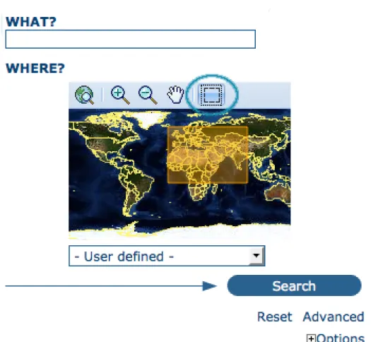
Free text search. Typea search term in theWhat? field. You can type anything here (free text). You can use quotes around text to find exact combinations of words.
Text and operators (and, or, not) are not case sensitive.
Geographic search. For the geographic search, two options are available for selecting a particular region to limit the search:
You can select aregionfrom a predefined list;
You can select your ownarea of interestin a more interactive way. A small global map is shown on the screen from which you can drag and drop the frame of your location area. Just click on the button on the upper right of the map screen.
Perform search. Both types of search, free text search and geographic search can be combined to restrict the query further.
Click theSearchbutton to proceed and show the results.
2.2.2 Searching by Categories
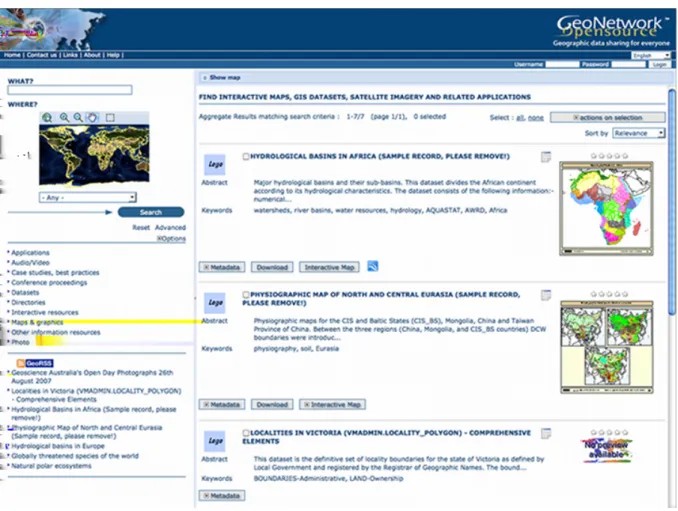
An additional way to search data within the GeoNetwork database, from the home page, is searching by Category. A list of categories is provided to the user to identify data at a more generic level: Applica-tions,Audio/Video,Case study and best practises,Conference proceedings,Datasets,Directories, Interactive resources,Maps and graphics,Other information resources,Photo.
To search only for maps, click onMaps and Graphics. A list of maps will be displayed from which you may view details of every single map; just clicking on theMetadatabutton of the map you wish to review.
Figure 2.1:The free text field.
GeoNetwork User Manual, Release 2.10.4-0
Figure 2.3:Interactive Area Of Interest map
Figure 2.4:The Search button
GeoNetwork User Manual, Release 2.10.4-0
Figure 2.5:Search by Category
2.2.3 Advanced Search
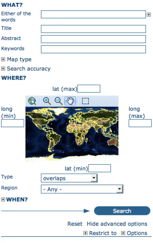
The advanced search option works similarly to the default search. However, you can be more specific in your search criteria as it offers different elements to look for data, each of them focusing one of the following aspects:What?, Where?, When?
To perform anadvanced search, from the home pageclick Advancedjust below the search bottom. In theWHAT? section the elements are all related to the data content. Through them, in addition to searching only free keywords in the entire metadata content, you can also search directly in the title or abstract fields and add more keywords to customise your search further. You can also specify the level of accuracy you wish to reach in performing your search.
• To search byTitle, Abstract, Free Text, or Keyword(s)type any text into the respective field. You can enter information in one or multiple field(s). If you do not want to search by a given field, simply leave it blank;
• You can choose theaccuracy of your search, in terms of spelling words, from Precise= 1 to Imprecise= 0.2, through 3 more consecutive steps which are equal to 0.8, 0.6, 0.4.
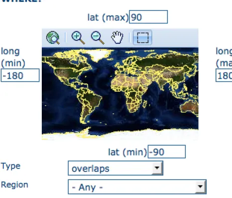
TheWHERE?parameters, which are related to the spatial extent, allow you, as in the default search, either to select your own area of interest or to select a predefined region from the drop-down list. In this section you can also type the geographic coordinates of a specific location that is not available from the above list.
• To selectyour own area of interest, drag and drop the frame of your area on the global map using the appropriate tool on the bottom left of the map screen;
• To usefree coordinates, type the lat-long geographic references in the appropriate fields around the map screen, without any limitation of decimal figures;
• To use the coordinates of apredefined region, select the region from the drop-down list.
Whatever type of geographic search you decide to perform, in theSpatial search typefield, you can choose from different options:is,overlaps,encloses,is fully outside of. If you use this field, be cautious
Figure 2.6:Advanced search options
GeoNetwork User Manual, Release 2.10.4-0
Figure 2.7:Show advanced search options
Figure 2.9:“Where” section in the Advanced search
• If you chooseSpatial search typeis“Country”, only maps for the selected country will be dis-played. In other words, a city map within that country will not show in the output results.
• If you chooseSpatial search typeoverlaps“Country”, all maps with the bounding box overlap-ping that country will be displayed in the results, i.e. the neighbouring countries, the continent of which that country is part of and the global maps.
• If you chooseSpatial search typeencloses“Country” you will get, in the output results, maps of that country first and then all maps within its bounding box.
• Similarly, if you chooseSpatial search typeis fully outside of a selected region, only maps that follow that exact criteria will show in the output results.
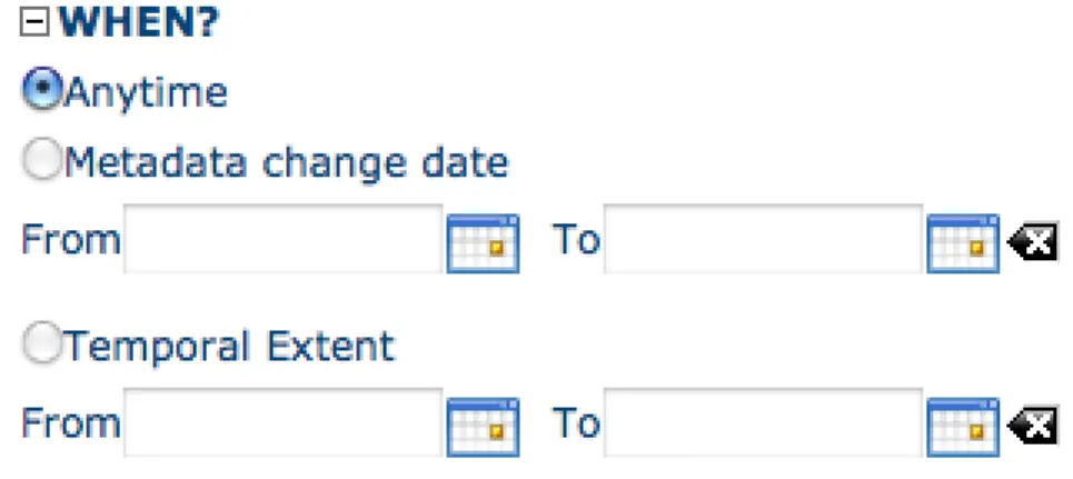
TheWHEN?section gives you the possibility to restrict your search in terms of temporal extent, indi-cating a specific range of time referred to the data creation or publication date.
• To specify a range of time, click on the date selector button next toFrom – Tofields. Make use of the symbols>and>>on top of the calendar to select the month and the year first and then click on the exact day; a complete date will be filled in using the following standard order: YY-MM-DD. • To clean the time fields, simply click on the white cross on their right; the box Any will be
automatically selected and the search will be performed without any restriction on the time period. Finally, the advanced search allows you to apply further restrictions on the basis of additional parameters as data source, data categories and data format.
• To limit your queries to only oneCatalogueout of those made available by the installation through the harvesting process, highlight the catalogue of preference or just keepAnyselected to search all sites.
• To search for data organised byCategory, such as Applications, Datasets, etc., simply highlight the category you wish to search in from the related drop-down list, otherwise we suggest to leave
GeoNetwork User Manual, Release 2.10.4-0
Figure 2.10:“When” section in the Advanced search
this field inAnyCategory.
• You can search forDigitalorHard Copymaps. To search in one or the other, simply check the box next to the one you wish to search. If no box is checked, all content will be searched.
At last, you can customise the number of output results per page in the Hits Per Page field. Simply highlight the number of records to be displayed or leave the field set on the default number (10).
• Click theSearchbutton.
Figure 2.11: Other options in the Advanced search
Inspire
If INSPIRE Search panel is enable in Administration > System configuration page, an additional section is displayed to allow searching INSPIRE metadata in the catalog.
• Annex: Allows to search for metadata related to a specific Inspire annex. The Inspire annexes for a metadata are based on the Inspire theme keywords assigned to it.
Figure 2.12:“Inspire” section in the Advanced search
GeoNetwork User Manual, Release 2.10.4-0
• Classification of data services: Allows to search for metadata that have selected keyword from theInspire service taxonomythesaurus.
• Inspire themes: Allows to search for metadata that have selected keywords from theInspire themes thesaurus.
2.2.4 Search Results
The output of a search provides you a list of the metadata records that should fit your request. For each record, the result page shows the title, an abstract and the keywords. According to the privileges that have been set for each metadata, a maximum of four sections can be consulted, as shown below.
Figure 2.13:Search results
1. Metadata: The metadata section describes the dataset (e.g.: citation, data owner, tempo-ral/spatial/methodological information) and could contain links to other web sites that could pro-vide further information about the dataset.
2. Download: Depending on the privileges that have been set for each record, when this button is present, the dataset is available and downloadable. The process for retrieving data is simple and quick by just clicking the download button or by using the proper link in the specific metadata section for distribution info in the full metadata view.
Figure 2.14:A single search result
Figure 2.15:Available services related to the resource
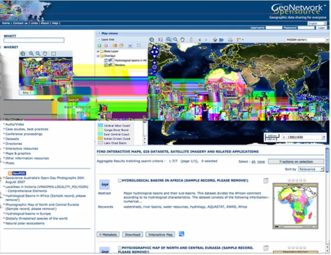
search. To better visualise the map through the map viewer,clickon Show Mapon the top of search results panel.
4. Graphic Overviews: There are small and large overviews of the map used to properly evaluate usefulness of the data, especially if the interactive map is not available. Simply click on the small image to enlarge it.
2.2.5 Privileges, roles and user groups
GeoNetwork uses a system ofPrivileges,RolesandUser groups.
There are no restrictions for users to search and accesspublic informationin a GeoNetwork opensource based catalogue. To get access torestricted informationor advanced functionality, an account to log in is required. This should be provided by the GeoNetwork administrator.
To log in, simply go to the home page and enter your username and password in the dedicated fields on the top right corner, then click the login button.
Privileges. Depending on the privileges set on a metadata record and on your role as an authenticated user, you will be able to read about a resource and download or interactively browse data related to that resource.
GeoNetwork User Manual, Release 2.10.4-0
Figure 2.17: Large preview image
Figure 2.18:Login
GeoNetwork User Manual, Release 2.10.4-0
Roles. Users with anEditorrole can create, import and edit metadata records. They can also upload data and configure links to interactive map services.
User groups. Every authenticated user is assigned to a particular work group and is able to view data within that work group.
2.3 Viewing and Analysing the Data
Once you have completed your search, you view details of a particular record by clicking on the Meta-databutton.
The metadata profiles used by GeoNetwork opensource to present and describe geographic data and general documents stored in the catalogue are based on theInternational Standard ISO 19115:2003, encoded according to theimplementation schema 19139:2007, theFGDCand the international standard Dublin Core.
In this guide theISO 19139metadata implementation will be described in details since it is also sug-gested as profile for the creation of new metadata records.
2.3.1 Metadata Description
The metadata ISO 19139 profile used by GeoNetwork opensource to describe the geographic data and services is based on the ISO standard 19115:2003 and provides information related to the identification, the maintenance and constraints, the spatial and temporal extent, the spatial representation and reference, the quality and distribution of a geographic dataset.
The metadata profile is organised in sections and the most important, illustrated below, are the: Iden-tification Section, Distribution Section, Reference System Section, Data Quality Section and Metadata Section. These sections are described here in details.
Identification Section
This section includes information on the citation of the resource (title, date of creation or publication, edition, presentation form), theabstract, thepurposeand the present*status* of the resource that can be defined among the options: completed, historical archive, obsolete, ongoing, planned, required or under development.
This section also contains information about the person or organisation responsible for the data and who is considered to be apoint of contactfor the resource i.e. the dataset owner, originator, distributor, pub-lisher, etc. and it provides information ondata maintenancei.e. annually, monthly, daily, not planned, as needed, etc.
Elements forkeywordsand for describing restrictions ondata accessanduseare also included in this section in addition tospatial representation infolike data type (vector, raster, text table, etc.)
The identification section provides information about thescale, the languageand character set used within the resource and the list ofISO categoriesthrough which your map could be classified.
Finally, the temporal and spatial extent are also defined in this section. The temporal extent is defined through the starting and ending date of data validation.
Figure 2.19:Main metadata sections
GeoNetwork User Manual, Release 2.10.4-0
Figure 2.21:Point of Contact
GeoNetwork User Manual, Release 2.10.4-0
Figure 2.24:Temporal extent
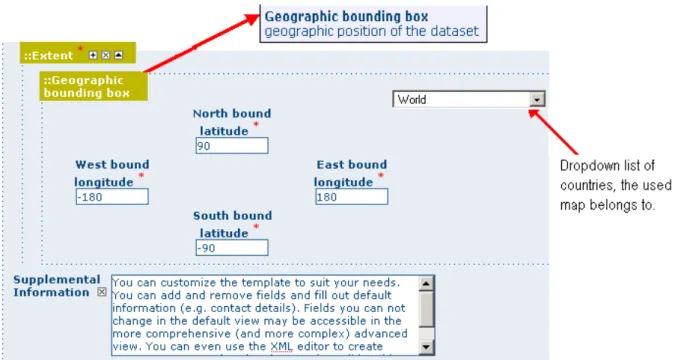
The spatial extent of the interested area is defined through geographic coordinates or through the selec-tion of a country or region from a predefined list. Free textsupplemental informationcan be added to complete the data identification section.
Figure 2.25:Geographic bounding box
Distribution Section
This section provides metadata elements foraccessingother usefulon-line resourcesavailablethrough the web. The distribution elements allow for on-line access using an URL address or similar addressing scheme and provide the protocol for the proper connectionfor accessing geographic dataor any other types of digital documentsusing the download function. Furthermore, it is possibleto linka metadata with apredefined map servicethrough theonline resourceand see the map interactively.
GeoNetwork User Manual, Release 2.10.4-0
Figure 2.26:Distribution information Reference System Section
The Spatial Reference System sectiondefines metadatarequiredto describethespatial reference system of a dataset. It contains one element to identify the name of the reference system used. Using elements from the advanced form, this section may be modified to provide moredetailsondata projection, ellip-soidanddatum. Note that if this information is provided, a reference system identifier is not mandatory.
Figure 2.27:Reference system
Data Quality Section
The Data Quality section provides a general assessment of the quality of the data. It describes the*different hierarchical levels of data quality*, namely adataset series,dataset,features,attributes, etc. This section also contains information aboutsources of the input data, and ageneral explanation of the production processes(lineage) used for creating the data.
Figure 2.28:Data quality
(‘Date stamp’) and themetadata standardandversion nameof the record. It also contains information on themetadata author responsible for the metadata record; this person can also be a point of contact for the resource described. Information on the Metadata author is mandatory.
2.4 Adding a metadata record
This section guides you through the process of adding new metadata records with associated data and/or services into the GeoNetwork catalog. You will use metadata template records, add thumbnails, upload data, link to services and set access privileges to the metadata and the data it describes.
To add or edit metadata, you must beregisteredas a user with anEditor profile or higher. That user should be a member of the User Group you want to add information for. Contact your administrator if you are not a registered Editor for your User Group.
For metadata creation using the online editor, GeoNetwork provides a set of simplified metadata tem-plates based on the cited standards available in your GeoNetwork instance: typically ISO19139 (an implementation of ISO19115), FGDC and Dublin Core. The templates for describing vector or raster geographic data based on ISO19139 are preferred because they are devised in a way that hides much of the complexity of the ISO19115 standard in the default view. At the same time those templates are extensible with new elements to fit specialized needs through the advanced view.
To produce a good metadata record, always try to:
• gather as many details as possible on the resource that you want to describe taking into account the metadata elements that have been presented in the previous chapter
• develop and reuse the same terms or phrases to describe the concepts you want to capture. A record of these terms and phrases will be helpful for others in understanding your metadata. The next step is to fill out properly the fields provided by the metadata templates, while at the same time avoiding duplication of information throughout the form.
The most important fields that may not be waived while compiling a standard based metadata record are the following: Title, Date of Creation or Publication, Abstract, Language used for documenting data, Topic Category, Scale, Maintenance and Update Frequency, Metadata Author, Language Used for Documenting Metadata.
In addition to the main mandatory fields, we recommend you to fill out these optional but critical fields (if information is available):Purpose - Keywords - Presentation Form - Status - Spatial Representation
GeoNetwork User Manual, Release 2.10.4-0
Type Geographic Location Reference System Info Temporal Extent Data Quality Info -Access and Use Constraints - Point of Contact - Distribution Info: Online Resources.
You should also prepare an image of your data that is required to be displayed in search results as thumbnail.
Next section will guide you through the process of metadata creation using the online editor.
2.4.1 Creating a New Record using the Metadata Editor
1. In the home page, click on theAdministration Tab. 2. SelectNew Metadatafrom the List of the admin page.
3. Select the metadata standardTemplate, if possible, using the preferred ones. GeoNetwork open-source comes by default with support for three metadata standards, ISO19139, FGDC and Dublin core. For the ISO standard, two templates have been developed; one for vector and one for raster data. Both contain a relevant set of elements to describe the respective types of data. More tem-plates can be developed online.
4. Select theGroupthe metadata will belong to. These are the groups authorized to add metadata to by your administrator.
5. Click onCreate.
2.4.2 The steps in more details
1. Enter your username and password and click on the login button. The system will identify you and assign the correct privileges to work with.
Figure 2.30:Login
2. Open the Administration page by clicking the Administration button in the banner and then click on the New metadata link.
3. From the metadata creation page, select the metadata standard to use from the dropdown list (Figure 4.3, “Template selection”)
4. After selecting the correct template, you should identify which group of users the metadata will belong to and finally click onCreate.
5. A new metadata form based on the selected template will be displayed for you to fill out.
GeoNetwork User Manual, Release 2.10.4-0
Figure 2.31:Administration panel
Figure 2.32:Template selection
2.4.3 Switching Editing Views from Default to Advanced to XML View
Once you create a new record, you can choose betweenDefault, AdvancedorXML View. To switch view, simply click on the view you want to switch to on the left column of the page. The view inboldis the view you are currently using.
Figure 2.34: Metadata view options
In the previous chapter you have analyzed the metadata structure as it is presented in theDefault View. A selection of the main fields from different categories of information is shown in one single view. The minimum set of metadata required to serve the full range of metadata applications (data discovery, determination of data fitness for use, data access, data transfer and use of digital data) is defined here, along with optional metadata elements to allow for a more extensive standard description of geographic data, if required. However, if should be there a need to add more metadata elements, you can switch to the advanced view at any time while editing.
In theAdvanced View, the ISO profile offers the possibility to visualize and edit the entire metadata structure organized in sections accessible through tabs from the left column. You can use this view to write more advanced metadata descriptions or templates to fit specialized needs.
TheXML Viewshows the entire content of the metadata in the original hierarchical structure; different colors allow to distinguish between an element’s name and its value. The XML structure is composed of tags and to every tag must correspond a closing tag. The content is entirely contained withing the two, i.e.:
<gmd:language>
<gco:CharacterString>eng</gco:CharacterString> </gmd:language>
Nevertheless, the use of the XML view requires some knowledge of the XML language.
Both the Default and the Advanced Views are composed of mandatory, conditional and optional metadata fields. The meaning of mandatory and optional is fairly intuitive; the manda-tory fields are required, like TitleandAbstractfor instance, whereas the optional fields can be provided but are not fundamental, depending on the metadata author. The conditional fields may be con-sidered mandatory under certain circumstances: essentially a conditional requirement indicates that the presence of a specified data element is dependent on the value or presence of other data elements in the same section. For instance, theIndividual namemetadata element of thePoint of Contact, which is a conditional element of the Identification section, becomes mandatory if another element of the same section,Organization nameorPosition nameis not already defined.
GeoNetwork User Manual, Release 2.10.4-0
Figure 2.37:Point of Contact
GeoNetwork User Manual, Release 2.10.4-0
The mandatory fieldsas well as thosehighly recommendedare flagged withred asterisk [*]. The standard definition for each field can be read by passing the mouse on the element name.
The Default Viewis the preferred view as it provides a selection of the available metadata elements, facilitating both the user and the editor in reading and editing a metadata record, and at the same time it ensures that a geospatial data can be properly described, through :
• the minimum set of metadata required to serve the full range of metadata applications (data dis-covery, determination of data fitness for use, data access, data transfer, and use of digital data); • optional metadata elements - to allow for a more extensive standard description of geographic
data, if required;
• a method for extending metadata to fit specialized needs.
2.4.4 Using basic commands of the editor
Fields are eitherfree text fields ordrop down lists. Free text means you can type any text into that field. Drop down lists allow you to select only one option from the list. You can add multiple fields of the same kind by clicking on the[+]symbol next to the element. Every new field that you will add in the advanced view will then be visible in the default view. You can also delete existing fields by clicking on the[x]symbol next to the element. Clearly, mandatory fields cannot be deleted. One example of the need to add multiple fields can arise if the content of your dataset has some text written in two different languages.
Figure 2.38:Describing multilingual data
2.4.5 Example: Entering metadata for a Thematic Map
gather as much information as possible to identify and understand the map’s resource and characteristics you want to describe. Use the default view to start. If necessary, you can always switch to advanced view or come back later and edit the record with the additional information collected.
Please follow these steps to enter your map’s metadata. Note that we will only go through the fields that have been identified as compulsory (i.e. those fields marked with the asterix [*], mandatory or highly recommended).
Title*: Under the Identification Info field, give your map a name. There will be a default name of your data. Use free text to describe your map here.
Date*: Indicate the exact date of creation, publication or revision on your map. Presentation Form: Specify the type of presentation, i.e. digital, hard copy, table, etc. Abstract*: Enter some description of the map.
Purpose: Enter a short summary of the purposes for your map to be developed.
Status: Specify the status of your map within the following options: completed, historical archive, obsolete, ongoing, planned, required, under development.
Point of Contact: Enter all mandatory information and others you have at hand for the contact of the person(s) associated with this resources of the map. Note that some fields are only conditionally mandatory, such as Organization Name if Individual Name and Position are not entered.
Maintenance and update frequency* : Specify the frequency with which you expect to make changes and additions to your map after the initial version is completed. If any changes are scheduled you can leave As Needed selected from the drop-down list.
Descriptive Keywords: Enter keywords that describe your map. Also specify the type of keyword you are entering, i.e. place, theme, etc. Remember that you can add another keyword field if you need to add different types of keywords.
Access Constraints: Enter an access constraint here, such as a copyright, trademark, etc. to assure the protection of privacy and intellectual property.
User Constraints: Enter a user constraint here to assure the protection of privacy and intellectual prop-erty.
Other Constraints* : Enter other constraint here to assure the protection of privacy and intellectual property. Note that this field is conditionally mandatory if Access and Use constraints are not entered. Spatial representation type: Select, from the drop-down list the method used to spatially represent your data. The options are: vector, grid, text table, stereo model, video.
Scale Denominator* : Enter the denominator for an equivalent scale of a hard copy of the map. Language*: Select the language used within your map
Topic category* : Specify the main ISO category/ies through which your map could be classified (see Annex for the complete list of ISO topic categories).
Temporal Extent* : Enter the starting and ending date of the validity period.
Geographic Bounding Box* : Enter the longitude and latitude for the map or select a region from the predefined drop-down list. Make sure you use degrees for the unit of the geographic coordinates as they are the basis for the geographic searches.
Supplemental Information: Enter any other descriptive information about your map that can help the user to better understand its content.
GeoNetwork User Manual, Release 2.10.4-0
Distribution Info: Enter information about the distributor and about options for obtaining your map. Online Resource: Enter information about online resources for the map, such as where a user may download it, etc. This information should include a link, the link type (protocol) and a description of the resource.
Reference System Info: Enter information about the spatial reference system of your map. The default view contains one element to provide the alphanumeric value identifying the reference system used. GNos uses the EPSG codes which are numeric codes associated with coordinate system definitions. For instance, EPSG:4326 is Geographic lat-long WGS84, and EPSG:32611 is “UTM zone 11 North, WGS84”. Using elements from the advanced view, you may add more details on data projection, ellip-soid and datum. Note that if this information is provided, a reference system identifier is not mandatory. Data Quality: Specify the hierarchal level of the data (dataset series, dataset, features, attributes, etc.) and provide a general explanation on the production processes (lineage) used for creating the data. The statement element is mandatory if the hierarchical level element is equal to dataset or series. Detailed information on completeness, logical consistency and positional, thematic and temporal accuracy can be directly added into the advanced form.
Metadata Author * : Provide information about the author of the map, including the person’s name, organization, position, role and any other contact information available.
After completion of this section, you may select the Type of document that you are going to save in the catalogue. You have three options: Metadata, Template, Sub-template. By default Metadata is set up. When done, you may clickSaveorSave and Closeto close the editing session.
2.4.6 Metadata validation
In editing mode, editors can validate the current metadata record against standard rules and recommen-dations.
For all standards, a first level of validation is made for XML metadata validation based on XML Schema (XSD). For ISO19139 records, other rules are checked:
• ISO recommendations
• GeoNetwork recommendations
• (Optional and not available by default) INSPIRE recommendations
The validation report display the list of rules checked and their status (pass or failed). The top checkbox allows to display only errors or all.
2.4.7 Creating a Thumbnail
To help the user identify a metadata record of interest, you can create a graphic overview (or thumbnail) in the form of an image and attach it to the metadata record. For example, if your metadata record describes some geographic dataset then the the graphic overview could be an image of the map with legend produced by an OGC Web Map Service.
You can associate two thumbnails with a record: a small thumbnail, which will be displayed in search results and a large thumbnail with more details in case the user is interested in more information. The large thumbnail will be displayed when the user clicks on the small thumbnail.
GeoNetwork User Manual, Release 2.10.4-0
To create a thumbnail, go to the editing menu. If you are no longer in editing mode, retrieve the metadata record using one of the search options then click on Edit. Then follow these simple steps:
From the editing menu, click on the Thumbnails button on the top or bottom of the page.
Figure 2.39:The thumbnail wizard button • You will be taken to the Thumbnail Management wizard.
• To create a small or large thumbnail, click on the Browse button next to either one. It is recom-mended that you use 180 pixels for small thumbnails and 800x600 for large thumbnails. Using the ‘Large thumbnail’ option allows you to create both a small and large thumbnail in one go. • You can use GIF, PNG and JPEG images as input for the thumbnails.
• A pop up window will appear allowing you to browse your files on your computer. Select the file you wish to create a thumbnail with by double-clicking on it.
• Click onAdd.
• Your thumbnail will be added and displayed on the following page. • You can then click on Back to Editing and save your record.
2.4.8 Compute bounding box from keywords
Editor can add extent information based on keyword analysis. • For each keywords
• Search for the keyword in thesaurus • If keyword in the thesaurus has an extent
• Add an extent with a description and a bounding box to the metadata record. The process could be run in 2 modes :
Figure 2.40:Thumbnail wizard
GeoNetwork User Manual, Release 2.10.4-0
• Replace : Remove all extent having only a bounding box (temporal, vertical and bounding polygon are not removed), and add the new one at the end.
Editor need to select keyword from a thesaurus with spatial information. The name is added to the extent description field.
Then in the other actions menu, the compute boundinx box menus are available:
The metadata is saved during the process and one extent is added for each keywords.
If user manually add keywords just before computing bounding box, then it’s recommended to save your metadata record before launching the action in order to have latest keywords taken into account.
2.4.9 Assigning Privileges
To assign privileges to your metadata record and any attached data you will need to identify User Groups and the privileges you want to assign to users in these groups. eg. View the metadata, download the data attached to the record, etc.
For instance, you can specify that the metadata and related services are visible to all (Internet users) or just to internal users only (Intranet). Privileges are assigned on a per group basis. Depending on the user profile (Guest, Registered User, Editor, Admin etc.) access to these functions may differ on a per user basis.
To assign privileges, follow these steps:
• Find your metadata record by using the search option. Whether you have multiple or single results from the search, on top of the individual record or next to the record you will always see a row of buttons including a Privileges button.
• Click on the Privileges button. A drop down menu will appear from which you can assign certain privileges to specific groups using checkboxes. Simply click on the small box next to the privilege to place or remove a checkmark. Set All and Clear All buttons allow you to place and remove the checkmarks all at once.
GeoNetwork User Manual, Release 2.10.4-0
Figure 2.43:Privileges settings
Below is a brief description for each privilege to help you identify which ones you should assign to which group(s).
Publish: Users in the specified group/s are able to view the metadata eg. if it matches search criteria entered by such a user.
Download: Users in the specified group/s are able to download the data.
Interactive Map: Users in the specified group/s are able to get an interactive map. The interactive map has to be created separately using a Web Map Server such as GeoServer, which is distributed with GeoNetwork.
Featured: When randomly selected by GeoNetwork, the metadata record can appear in the Featured section of the GeoNetwork home page.
Notify: Users in the specified group receive notification if data attached to the metadata record is down-loaded.
2.4.10 Assigning Categories
Each GeoNetwork site has a set of local categories that can be used to classify metadata records for easy searching. To assign categories to a metadata record, follow these steps:
• Find your metadata record using the search option. Whether you have just one or many results from your search, you will always see a row of buttons including aCategoriesbutton.
• Click on theCategoriesbutton. A drop down menu will appear from which you can assign one or more categories using checkboxes. Simply click on the small box next to the category to place or remove a checkmark.
GeoNetwork User Manual, Release 2.10.4-0
2.4.11 Multilingual metadata in ISO19139
Editors can create multilingual metadata for ISO19139. A default template is provided but user could add translation to an existing record.
To declare a new language in a metadata record:
• First check, the main language is defined in the metadata section
• then add one or more languages in the other language in the metadata section. In editing mode, each multilingual elements are composed of:
• text input
• language selection list (language declared on the other language section are listed here) By default, the selected language is the GUI language if language is defined in the metadata.
Alternatively, Google translation service could be used. Translation could be suggested to the editor using the small icon right to the language selector. The translation convert the default metadata character string in the current selected language.
In view mode, according to GUI language : if GUI language is available in the metadata, the element is displayed in this language else the element is displayed in metadata default language. This behaviour is also applied to dublin core output for CSW services.
2.5 Uploading a New Record using the XML Metadata Insert Tool
A more advanced procedure to upload a new metadata record in the GeoNetwork system is using an XML document. This procedure is particularly useful for users who already have metadata in XML format, for instance created by some GIS application. To this regard, it has to be noted that the metadata must be in one of the standards used by GeoNetwork: ISO19115, FGDC and Dublin Core.To start the metadata uploading process through theXML Metadata Inserttool, you should log in and select the appropriate option from the Administration page.
The main part of the pageImport XML Formatted Metadatathat is displayed is theMetadata text area, where the user can paste the XML metadata to import. Below this, there is theTypechoice, which allows you select the type of record that you are going to create (Metadata, Template and Subtem-plate). Then you can apply a stylesheet to convert your metadata input from ArcCatalog8 to ISO1915 or from ISO19115 to ISO19139, if required. Otherwise you can just leave none selected. The Destina-tion schemalist provides you with four options to choose the final standard layout for your metadata (ISO19115, ISO19139, FGDC and Dublin Core). Finally you should select theGroup as main group in charge of the metadata and theCategorythat you want to assign to your metadata. By clicking the Insertbutton the metadata is imported into the system; please note that all links to external files, for instance to thumbnails or data for download, have to be removed from the metadata input, to avoid any conflict within the data repository.
GeoNetwork User Manual, Release 2.10.4-0
Figure 2.45:Administration panel
If your metadata is already in ISO19115 format, the main actions to be performed are the following: 1. Paste the XML file that contains the metadata information in theMetadatatext area;
2. Select Metadata astypeof record that you are going to create
3. Select the metadata schema ISO19139 that will be the finaldestination schema;
4. Select thevalidatecheck box if you want your metadata to be validated according to the related schema.
5. Select thegroupin charge of the metadata from the drop down list; 6. SelectMaps and Graphicsfrom the list of categories;
7. Click theInsertbutton and the metadata will be imported into the system.
2.6 Metadata in Spatial Data Management
2.6.1 What is Metadata?
Metadata, commonly defined as “data about data” or “information about data”, is a structured set of in-formation which describes data (including both digital and non-digital datasets) stored in administrative systems. Metadata may provide a short summary about the content, purpose, quality, location of the data as well as information related to its creation.
Figure 2.46:XML metadata import tool
GeoNetwork User Manual, Release 2.10.4-0
2.6.2 What are Metadata Standards?
Metadata standards provide data producers with the format and content for properly describing their data, allowing users to evaluate the usefulness of the data in addressing their specific needs.
The standards provide a documented, common set of terms and definitions that are presented in a struc-tured format.
2.6.3 Why do we need Standardised Metadata?
Standardised metadata support users in effectively and efficiently accessing data by using a common set of terminology and metadata elements that allow for a quick means of data discovery and retrieval from metadata clearinghouses. The metadata based on standards ensure information consistency and quality and avoid that important parts of data knowledge are lost.
2.6.4 Geographic Information Metadata Standard
Geographic data, which can be defined as any data with a geographic component, is often produced by one individual or organisation, and may address the needs of various users, including information system analysts, programme planners, developers of geographic information or policy makers. Proper standard documentation on geographic data enable different users to better evaluate the appropriateness of data to be used for data production, storage, update.
The metadata standards supported by GeoNetwork opensource are theISO 19115:2003- approved by the international community in April 2003 as a tool to define metadata in the field of geographic infor-mation - and theFGDC- the metadata standard adopted in the United States by the Federal Geographic Data Committee. In addition, GeoNetwork opensource supports also the international standardDublin Corefor the description of general documents.
This ISO Standard precisely defines how geographic information and related services should be de-scribed, providing mandatory and conditional metadata sections, metadata entities and metadata ele-ments. This standard applies to data series, independent datasets, individual geographic features and feature properties. Despite ISO 19115:2003 was designed for digital data, its principles can be extended to many other forms of geographic data such as maps, charts, and textual documents as well as non-geographic data.
The underlying format of an ISO19115:2003 compliant metadata is XML. GeoNetwork uses theISO Technical Specification 19139 Geographic information - Metadata - XML schema implementationfor the encoding of this XML.
2.6.5 Metadata profiles
A metadata profile is an adaptation of a metadata standard to suit the needs of a community. For example, the ANZLIC profile is an adaptation of the ISO19115/19139 metadata standard for Australian and New Zealand communities. A metadata profile could be implemented as:
• a specific metadatatemplatethat restricts the fields/elements a user can see with a set of validation rules to check compliance
• all of the above plus new fields/elements to capture concepts that aren’t in the basic metadata standard
GeoNetwork User Manual, Release 2.10.4-0
Building a metadata profile is described in the Schema Plugins section of the GeoNetwork Developers Manual. Using this guide and the GeoNetwork schema plugin capability, a profile can be built by an experienced XML/XSL software engineer.
2.6.6 Transition between metadata standards
With the ISO19115:2003 Metadata standard for Geographic Information now being the preferred com-mon standard, many have a need to migrate legacy metadata into the new standard.
GeoNetwork provides import (and export) functionality and has a number of transformers in place. It is an easy process for a system administrator to install custom transformers based on XSLT.
2.7 New Features
The new GeoNetwork opensource comes with substantial upgrades of different components.
2.7.1 2.10 release
Search
• Faceted search: Narrow your search by easily selecting new filter
• Data Catalog Vocabulary and RDF services: Increase discoverability and enable applications easily to consume metadata using W3C DCAT format
• Javascript widget user interface: A 3rd flavour of home page based on HTML5 is also available
Metadata
• Metadata on maps: Add template for making metadata on static or interactive maps. Add a search criteria for easily found maps. Web Map Context could be loaded into the map viewer. • Metadata linked data: Easier metadata relation configuration and new support for source dataset
and siblings. Seemetadata_link)
• Hide part of metadata: Provide a method to hide portions of metadata using withHeld ISO attribute
• Wiki markup in metadata: Allow users to enter markup text in metadata elements and have results shown with rendered html
• WFS data downloader: Simple component to download WFS data
Administration
• User profile: Setup user belonging to multiple groups with different profiles • Virtual CSWconfiguration interface to add new end points
Others
• Security layer: New security layer based on Spring Security adding support for CAS and much more flexible LDAP configuration
• Xlink: Add local:// as a protocal for xlink links
• Provide basic functionnalities (ie. search and view) whendatabase is in readonly
2.7.2 2.8 release
User interface
• Javascript widget user interface: A new user interface using one of the latest Javascript widget libraries (extJS) has been added to support searching, editing and viewing metadata records. The user interface is now much easier for Javascript developers to reorganize and customize. GeoNet-work comes with two flavours of home page: one has the sidebar search similar to the old interface and the other uses a tabbed search layout. The 2.6.x user interface is still available as the default and has been updated.
Figure 2.48:New home page of GeoNetwork opensource using JavaScript Widgets - tab layout
Administration
• Search Statistics: Captures and displays statistics on searches carried out in GeoNetwork. The statistics can be summarized in tables or in charts using JFreeChart. There is an extensible inter-face that you can use to display your own statistics. SeeSearch Statistics.
• New Harvesters:OGC Harvesting: Sensor Observation Service, Z3950 harvesting, Web Acces-sible Folder (WAF), GeoPortal 9.3.x via REST API SeeHarvesting.
GeoNetwork User Manual, Release 2.10.4-0
Figure 2.49:New home page of GeoNetwork opensource using JavaScript Widgets- sidebar layout
• Harvest History and Scheduling:Harvesting events are now recorded in the database for review at any time. SeeHarvest History. Harvester scheduling is now much more flexible, you can start a harvest at any time of the day and at almost any interval (weekly etc).
• Extended Metadata Exchange Format (MEF):More than one metadata file can be present in a MEF Zip archive. This is MEF version 2. SeeExport facilities.
• System Monitoring:Automatically monitoring the health of a Geonetwork web application. See System Monitoring.
Metadata
• Metadata Status: Allows finer control of the metadata workflow. Records can be assigned a status that reflects where they are in the metadata workflow: draft, approved, retired, submitted, rejected. When the status changes the relevant user is informed via email. eg. when an editor changes the status to ‘submitted’, the content reviewer receives an email requesting review. See Status.
• Metadata Versioning: Captures changes to metadata records and metadata properties (status, privileges, categories) and records them as versions in a subversion respository. SeeVersioning. • Publishing data to GeoServer from GeoNetwork:You can now publish geospatial information
in the form of GeoTIFF, shapefile or spatial table in a database to GeoServer from GeoNetwork. SeeGeoPublisher.
• Custom Metadata Formatters: You can now create your own XSLT to format metadata to suit your needs, zip it up and plug it in to GeoNetwork. SeeFormatter.
sembled from reusable components (eg. contact information). The components can be present in the local catalog or brought in from a remote catalog (with caching to speed up access). A com-ponent directory interface is available for editing and viewing the comcom-ponents. SeeFragments. • Editor Improvements:Picking terms from a thesaurus using a search widget, selecting reusable
metadata components for inclusion in the record, user defined suggestions or picklists to control content, context sensitive help, creating relationships between records.
• Plug in metadata schemas:You can define your own metadata schema and plug it into GeoNet-work on demand. Documentation to help you do this and example plug in schemas can be found in the Developers Manual. Some of the most common community plug in schemas can be down-loaded from the GeoNetwork source code repository. SeeSchemas.
• Multilingual Indexing: If you have to cope with metadata in different languages, GeoNetwork can now index each language and search all across language indexes by translating your search terms. SeeMultilingual search.
• Enhanced Thesaurus support: Thesauri can be loaded from ISO19135 register records and SKOS files. Keywords in ISO records are anchored to the definition of the concept in the the-saurus. SeeThesaurus.
CSW service
• Virtual CSW Endpoints: Now you can define a custom CSW service that works with a set of metadata records that you define. SeeVirtual CSW server entry points.
INSPIRE Directive
• Support for the INSPIRE Directive: Indexing and user interface extensions to support those who need to implement the INSPIRE metadata directive (EU).
• Installer package to enable INSPIRE options:An optional new package in the installer enables GeoNetwork INSPIRE features if selected, avoiding manual steps to enable INSPIRE support.
Other
• Improved Database Connection Handling and Pooling: Replacement of the Jeeves based database connection pool with the widely used and more robust Apache Database Connection Pool (DBCP). Addition of JNDI or container based database connection support. SeeDatabase configuration.
• Configuration Overrides: Now you can add your own configuration options to GeoNetwork, keep them in one file and maintain them independently from GeoNetwork. SeeConfiguration override.
• Many other improvements: charset detection and conversion on import, batch application of an XSLT to a selected set of metadata records (seeProcessing), remote notification of metadata changes, automatic integration tests to improve development and reduce regression and, of course, many bug fixes.
GeoNetwork User Manual, Release 2.10.4-0
2.8 Installing the software
2.8.1 Where do I get the installer?
The software is distributed through the SourceForge.net Website at http://sourceforge.net/projects/geonetwork.
Use the platform independent installer (.jar) for all platforms except Windows. Windows has a .exe file installer.
2.8.2 System requirements
GeoNetwork can run either onMS Windows,LinuxorMac OS X.
Some general system requirements for the software to run without problems are listed below: Processor: 1 GHz or higher
Memory (RAM): 1 GB or higher
Disk Space: Minimum of 512MB of free disk space. Additional space is required depending on the amount of spatial data that you expect to upload.
Other Software requirements : A Java Runtime Environment (JRE 1.6.0). For server installations, Apache Tomcat and a dedicated JDBC compliant DBMS (MySQL, Postgresql, Oracle) can be used instead of Jetty and H2.
Additional Software
The software listed here is not required to run GeoNetwork, but can be used for custom installations. 1. MySQL DBMS v5.5+ (All)1
2. Postgresql DBMS v7+ (All)1 3. Apache Tomcat v5.5+ (All)1
Supported browsers
GeoNetwork should work normally with the following browsers: 1. Firefox v1.5+ (All)1
2. Internet Explorer v8+ (Windows) 3. Safari v3+ (Mac OS X Leopard)
2.8.3 How do I install GeoNetwork opensource?
Before running the GeoNetwork installer, make sure that all system requirements are satisfied, and in particular that the Java Runtime Environment version 1.6.0 is set up on your machine.
On Windows
If you use Windows, the following steps will guide you to complete the installation (other FOSS will follow):
Warning: Avoid installing in a directory containing spaces. Best is to install inc:\programs and not inc:\program files
1. Double click on geonetwork-install-2.10.x.exeto start the GeoNetwork opensource desktop in-staller
2. Follow the instructions on screen. You can choose to install the embedded map server (based onGeoServerand the European Union Inspire Directive configuration pack. Developers may be interested in installing the source code and installer building tools. Full source code can be found in the GeoNetwork github code repository athttp://github.com/geonetwork.
3. After completion of the installation process, a ‘GeoNetwork desktop’ menu will be added to your Windows Start menu under ‘Programs’
4. Click Start>Programs>GeoNetwork desktop>Start server to start the Geonetwork opensource Web server. The first time you do this, the system will require about 1 minute to complete startup. 5. Click Start>Programs>Geonetwork desktop>Open GeoNetwork opensource to start using
GeoNetwork opensource, or connect your Web browser tohttp://localhost:8080/geonetwork/
Figure 2.50:Installer The installer allows to install these additional packages:
GeoNetwork User Manual, Release 2.10.4-0
1. GeoNetwork User Interface: Experimental UI for GeoNetwork using javascript components based on ExtJs library.
2. GeoServer: Web Map Server that provides default base layers for the GeoNetwork map viewer. 3. European Union INSPIRE Directive configuration pack: Enables INSPIRE support in
GeoNet-work.
• INSPIRE validation rules.
• Thesaurus files (GEMET, Inspire themes). • INSPIRE search panel.
• INSPIRE metadata view.
4. GAST: Installs GeoNetwork’s Administrator Survival Tool. Seegast.
Installation using the platform independent installer
If you downloaded the platform independent installer (a .jar file), you can in most cases start the installer by simply double clicking on it.
Follow the instructions on screen (see also the section called On Windows). At the end of the installation process you can choose to save the installation script.
Figure 2.52:Save the installation script for commandline installations