a
Master Thesis, Industrial Engineering &
Management by Bart Essink
Scenario analysis of a ice
and snow control program
on the tactical level
Department of Industrial Engineering and
Business Information Systems (IEBIS)
Enschede, July 2014
Examination committee
Dr. ir. M.R.K. Mes (University of Twente)
Table of content
Preface ... A Summary ... B
Chapter 1: Introduction ...1
1.1 Twente Milieu N.V. ...1
1.2 The snow and ice control program ...3
1.3 Research motivation ...3
1.4 Problem chart ...4
1.5 Research question ...5
1.6 Scope of the project ...6
1.7 Conclusion ...7
Chapter 2: The snow and ice control program ...8
2.1 Snow and ice control program ...8
2.1.2 Types of slipperiness...9
2.1.3 Types of pavement ...9
2.2 Thawing materials ... 10
2.2.1 Freezing-point depression ... 10
2.2.2 Types of thawing materials ... 10
2.3 Current decision making process ... 11
2.3.1 Determination of the routes ... 11
2.3.2 Decision making process (on an operational level) ... 12
2.3.3 Important factors ... 13
2.4 Conclusion ... 13
Chapter 3: Literature review ... 15
3.1 Routing problems ... 15
3.1.1 Arc routing problems ... 15
3.1.2 Types of arc routing problems ... 16
3.1.3 Types of objective functions ... 17
3.2 Subtour elimination constraints ... 17
3.2.1 Subtour elimination difficulties ... 17
3.2.2 A stepwise subtour elimination restriction ... 17
3.3 Heuristics ... 18
Chapter 4: Model setup ... 19
4.1 Twente Milieu’s arc routing problem ... 19
4.1.1 Characteristics of the snow and ice control program ... 19
4.1.2 Translating the problem ... 19
4.2 Set of assumptions ... 20
4.3 Model characteristics ... 20
4.3.1 Nodes and arcs ... 21
4.3.2 The road network ... 21
4.3.3 The arc network ... 22
4.3.4 Arc distances ... 23
4.4 The ILP model... 23
4.5 Alternative solution methods ... 26
4.5.1 Maximizing truck usage ... 27
4.5.2 Releasing salting variable ... 27
4.5.3 Rewarding a salted street ... 27
4.5.4 Conclusion ... 28
4.6 The solution method ... 28
4.6.1 Seed customers ... 28
4.6.2 The model ... 29
4.7 Initializing parameters ... 32
4.7.1 Number of steps ... 32
4.7.2 Completing phase 1 ... 33
4.7.3 Solving time ... 33
4.7.4 Salt capacity ... 34
4.7.5 Truck speed ... 34
4.8 Conclusion ... 34
Chapter 5: Experimental results ... 35
5.1 Experimental results per scenario... 36
5.1.1 Location of the salt depot ... 36
5.1.2 Road prioritization ... 39
5.2.3 Number of trucks... 40
5.2 Overview KPIs per scenario ... 43
Chapter 6: Conclusion, recommendations and discussion ... 45
Recommendations ... 47
Discussion ... 49
Bibliography... 50
Appendix A: Freezing-point depression ...i
Appendix B: Sprinkle map ... ii
A
Preface
From November 2013 until June 2014, I have been working at Twente Milieu on the topic of snow and ice control. This rapport is the result of my graduation internship in order to obtain my Masters in Industrial Engineering & Management at the University of Twente.
I would like to thank Martijn Mes and Leo van der Wegen, my supervisors from the University of Twente, for guiding me through the process of writing my Master thesis. Their guidance and constructive feedback have been very valuable. I am also thankful for the opportunity Gerbert Stegehuis gave me to conduct my research at Twente Milieu.
Finally, I thank my family and friends for their support during my studies. Your patience, support, and encouragement have been of great help in order to obtain my Masters degree.
Bart Essink
B
Summary
Municipalities are, by law, responsible for the maintenance and cleaning of the road network. Snow and ice control is part of this responsibility. Twente Milieu carries out this task on behalf of several municipalities in Twente. This report is about creating insights, on a tactical level, into the snow and ice control process currently used at Twente Milieu. The focus is mainly put on Enschede. These insights can be used to make decisions whether to change certain aspects regarding the snow and ice control in the future.
Activities in the area of snow and ice control mainly take place during the evening or at night. With a budget of more than €500k, for the municipality of Enschede, and the impact it has on traffic safety, it is considered an important task. Table 1 shows some characteristics of the snow and ice control program. It can be seen that the number of salting times varies a lot. From a financial perspective, budgeting is difficult.
Season 2011-2012 2012-2013 2013-2014
Number of salting actions 22 83 19
Salt used (in tons) 1,180 2,771 509
Table 1: Characteristics of the ice and snow control
Snow and ice control program
Enschede determines annually the roads and cycle paths that need to be salted during the winter. A distinction is made between roads that need to be salted within three hours (phase 1) after the first signs of slipperiness, and roads that need to be salted within five hours after these signs appear (phase 2). Twente Milieu determines salting routes based on these roads with corresponding priorities. Determination of salting routes takes place without the use of professional planning techniques or planning software. For example, the salting routes of Enschede are set by dividing the sprinkle map (overview of all roads that need to be salted, Appendix A) into different sections. Subsequently, the salting route within a section is drawn based on experience, logic, and intuition. For this reason, it is not known whether the current routes are optimal and if the use of routing and planning techniques could reduce costs (i.e., minimize driven kilometers) and/or increase safety. Furthermore, the absence of professional planning techniques makes it rather difficult to assess the effects, both financially and in terms of safety, that arise when (tactical) changes are being made. Organizations need to be aware of cause and effect relations in their decision making process. Examples of such tactical decisions are:
What happens when there is a 10% reduction of the number of roads that needs to be salted?
What happens when no prioritization (in terms of time) is made between different roads? What happens when less salting vehicles are being used?
This thesis focuses on providing Twente Milieu with insights into the effects of such tactical decisions.
Solution method
C
incorporates an integral approach towards route optimization for the whole fleet. The corresponding model appears to be too big to solve in a reasonable timeframe. Thus an alternative formulation is required. The objective function of this model seeks for effective truck usage, i.e., a truck should salt as many roads as possible within a certain time interval. Instead of coming up with a route for the whole fleet at once, the ILP is solved iteratively for every available truck. In other words, a heuristic approach is used to solve an ILP per truck. The ILP provides a starting solution in which most roads are salted. The remaining streets are scheduled with an insertion heuristic. The insertion rule is based on distance minimization.
This solution method is applied to several scenarios such as: varying number of trucks, different depot locations, and allowing violation of road prioritization with corresponding completion times. Per scenario, the solution method calculates the distance travelled per truck, the salting time per truck, and the traversing time per truck. This information is used to compare the scenarios with each other.
Results
Table 2 contains information about every scenario.
Scenario category Scenario (averages) Distance travelled (km) Travelling time (min) Salting time (min) Differing depot location Current depot location (initial solution)
87.08 154.31 93.91
Depot west 87.19 156.01 92.63
Depot south 84.51 151.06 94.79
Depot east 91.35 154.67 93.55
Depot city centre 78.99 140.52 92.98
Adjusting completion time of phase 1
Normal completion time (initial
solution)
87.08 154.31 93.91
Extended completion time
89.61 157.15 92.74
Penalty for violating
completion time
92.91 161.95 91.57
Differing truck usage
11 trucks (initial solution)
87.08 154.31 93.91
10 trucks 93.06 166.24 102.32
[image:7.595.65.540.333.624.2]9 trucks 118.36 204.50 117.48
Table 2: Overview of all scenarios
D
Depot location
Locating the depot in the city centre does have a significant impact on the distance travelled per truck. It is recommended to use this knowledge in case the current depot is depreciated. This location becomes more important if fewer trucks are used. If fewer distance must be covered from the depot to a truck’s salting area, the chance that the completion time of phase 1 is respected increases. This distance travelled per truck depends on the depot location.
Fewer trucks
Using fewer trucks results in less incurred costs. In the case of 9 trucks, a truck takes, on average, 204.50 minutes to complete its route. 11 trucks take on average 154.31 minutes to complete their route. This is an extension of 33%. In the current situation, trucks take 2 to 2.5 hours to complete their routes. With this extension in mind, it seems permitted to use fewer trucks.
Truck differences
The differences between the trucks per scenario, with respect to the distance covered, the travelling time, and the salting time, are caused by the fact that some districts are more difficult to reach and salt. This effect is mitigated by the seed customers1 assigned per truck, however this effect cannot be eliminated. Furthermore, it is not necessary to construct equal routes in terms of distance covered, travelling time, and salting time.
Recommendation
Twente Milieu should start with an extensive discussion regarding the organization of the entire snow and ice control program. The subject of this debate is whether different salting routes, i.e., various scenarios could be used in the future. The information retrieved from the solution method can help in this process. Only if there is a consensus among different stakeholders (Management Team, municipalities, and the operation department), further steps could be taken.
At the moment, the discussion with respect to the snow and ice control program is mainly focused on the available financial resources. From the perspective of operational excellence, a better starting point would be to shift the focus from the current snow and ice control program and to ignore signals coming from the municipalities to carry out cost reductions. Improvements and cost reductions should be the result of strategic and tactical decision making processes, not the starting point. There are sufficient points of interest to start the discussion regarding the future of the snow and ice control program. Twente Milieu’s mission statement speaks of a waste-free society in 2030. Waste-free is a broad concept and could also be seen in light of minimal fuel consumption, seeking synergy by combining activities, and minimize the usage of vehicles. Furthermore, seeking synergy between municipalities was one of the goals set during the establishment of Twente Milieu. All municipalities are united within Twente Milieu, so it is the designated organization to take the lead in this process.
Twente Milieu’s mission statement and the aim of seeking synergy should be leading in the strategic and tactical discussion on winter maintenance. A relevant question is: ‘how do we see winter maintenance, in the context of a waste-free society, in 2030 on the level of Twente Milieu?’ Only if
1 A seed customer is a specific road that is assigned to a specific truck in order to guide that truck to a certain
E
there is a consensus among stakeholders regarding this question, further steps should be taken. Examples of further actions are: use Operation Research in order to determine depot locations (transboundary or not), determine an economically viable fleet size, set the routes. One should be aware that these actions do not determine how one sees winter maintenance in the future. These actions only give shape to the policy that was set prior to this.
1
Chapter 1: Introduction
In this chapter, an introduction on the entire graduation project is given. The chapter starts with an overview of the working activities at Twente Milieu. Thereafter, in Section 1.2, the snow and ice control program at Twente Milieu is introduced followed by the reason for conducting this research, its scope, limitations, and expected contributions to this control program.
1.1 Twente Milieu N.V.
Twente Milieu N.V. is a government-owned company. The shares are owned by seven municipalities in Twente: Almelo, Borne (since October 2013), Enschede, Hengelo, Hof van Twente, Losser and Oldenzaal. Furthermore, these seven towns are also the main customers of Twente Milieu. The main objective of Twente Milieu is not profit maximization but ‘impact maximization’ (Twente Milieu, 2012). Twente Milieu is a specialist in garbage disposal, managing public space, sewage management, pest control, and ice control. These tasks are carried out in light of offering high societal value for low community costs.
Mission statement and vision
The primary activity of Twente Milieu is in the area of garbage disposal and waste management. This is also reflected in the mission statement (Twente Milieu, 2013):
‘Twente Milieu contributes to a clean and healthy environment.’
This mission has been translated into Twente Milieu’s dream, namely to establish a waste-free society. In 2030, waste is being processed into raw materials by moving away from the current linear economy towards a circular economy (cradle to cradle) (Twente Milieu, 2013). Nowadays, Twente Milieu uses awareness campaigns in order to change people’s and organization’s attitude towards waste. Furthermore, a more intelligent garbage collection system, that focuses on waste sorting, is being used in order to shape Twente Milieu’s dream.
Ice and snow control
The idea behind a waste-free society can also be applied to other fields in which Twente Milieu is active. In a broad sense, minimizing or even eliminating environmentally harmful activities, such as the inefficient usage of fossil fuel or the unnecessary use of company cars, all contributes to Twente Milieu’s mission. This research is in the area of winter maintenance. In the spirit of the previous stated dream, Twente Milieu seeks for collaboration between all municipalities in order to generate efficient salting routes and an effective salting program. Only this contributes to safe traffic conditions and a low carbon footprint for minimal community costs.
Municipalities are, by law, responsible for the maintenance and cleaning of the road network and the public space as defined in the Wegenwet2. These tasks are carried out by Twente Milieu on behalf of the shareholders (municipalities). Annually, a service level agreement (SLA) is signed in which all
2
2
tasks and responsibilities of all parties are specified in. The agreements, with respect to the ice and snow program, are as follows (Twente Milieu; Gemeente Enschede, 2013):
preventing slipperiness on all public roads and cycle paths according to the prioritization list (appendix A) provided by the municipalities;
salting starts within 45 minutes after signaling slipperiness;
24/7 availability of snow & ice fighters between November 1st and March 31e.
During the snow and ice control season, approximately 150 snow & ice fighters and 40 salt spreaders are available (Twente Milieu, 2013).
Key figures
In 2012, Twente Milieu served approximately 400.000 citizens in these seven municipalities. 202.6 kg (x106) of waste has been collected and per salting action approximately 1000 km is salted. Some financial figures are presented in Table 3.
Organization chart
[image:11.595.62.537.295.380.2]The management team of Twente Milieu consists of eight people, namely: the director, three location managers (Almelo, Enschede, and Hengelo), a fleet manager, a staff manager, a financial manager and a facility manager. The structure is depicted in Figure 1.
Figure 1: Organization chart
Revenue €28,590,311
Profit €792,360
Employees 228
FTE 215
Average age 46.1
[image:11.595.126.473.472.741.2]Sick leave 7.6%
3
1.2 The snow and ice control program
All five3 municipalities determine annually the roads and cycles paths that need to be salted during the winter. A distinction is made between roads that need to be salted within three hours after the first signs of slipperiness and roads that need to be salted within five hours after these signs. Twente Milieu determines salting routes based on these roads with corresponding priorities. Such determination of salting routes takes place without the use of professional planning techniques or planning software. For example, the salting routes of Enschede are set by dividing the sprinkle map (Appendix A) into different sections. Subsequently, the salting route within a section is drawn based on experience, logic, and intuition. For this reason, it is questionable whether the current routes are optimal and that the use of routing and planning techniques could reduce costs (i.e., minimize driven kilometers) and increase safety.
Furthermore, the absence of professional planning techniques makes it rather difficult to assess the effects, both financially and in terms of safety, that arise when (tactical) changes are being made. Organizations need to be aware of cause and effect relations in their decision making process. Examples of such tactical decisions are: what happens when there is a 10% reduction of the number of roads that needs to be salted?, what happens when no prioritization (in terms of time) is made between different roads?, what happens when less salting vehicles are being used? This thesis focuses on providing Twente Milieu with insights in the effects of such tactical decisions.
Additionally, it is questionable whether the current method of organizing the snow and ice control program at Twente Milieu is effective. Twente Milieu starts salting all predefined routes as soon as the Province Overijssel starts salting provincial roads and highways or MeteoConsult indicates that roads are becoming slippery. All routes are being salted regardless whether this is actually effective. For example, continuously sprinkling roads during a non-stop snow storm is very ineffective. Municipalities could consider snow plowing after the snowstorm and subsequently apply salt on the road. During the snowstorm, only the traffic arteries are kept free of snow. Such an approach is much more cost effective.
1.3 Research motivation
Nowadays, government finds itself in a financially difficult situation. Most budgets are cut and cost minimization has become increasingly important. This also holds for the participating seven municipalities in Twente Milieu. For this reason, Twente Milieu expects budget loss for their ice and snow control program in the near future. It is questionable whether the current way of working and expected cutbacks from the city of Enschede suit each other.
In order to guarantee the traffic safety in the future, funded by tighter budgets, the current snow and ice control program needs to be examined. This is done both on the organizational and technical level as well as the funding model. These three fields of study are explained in more detail in the problem chart.
4
1.4 Problem chart
[image:13.595.70.525.212.656.2]A problem chart is a technique to expose cause and effect relations. It is an illustrative way to make problems tangible and it clarifies the cohesion of problems in which they occur. This helps structuring the problem context. Furthermore, it is a useful tool to discuss the problem(s), because the chance of miscommunication reduces due to the visualization of the web of problems. It is also a means to get the key stakeholders on the same page in order to prevent disagreement, at a later stage, about the problems and the resulting solutions. The problem chart is presented in Figure 2 followed by an explanation per problem in Table 4.
Figure 2: The problem chart
Problem number
Explanation of the problem
1 Twente Milieu has no knowledge about creating routes.
2 All 20 routes are predefined. In case the salt spreaders move out, all routes are being salted.
3 Twente Milieu does not possess advanced planning techniques and software, therefore it is hard to assess cause and effect relations when tactical changes are being considered or implemented.
4 Salting streets during prolonged snowfall (when road usage is low) is ineffective.
5 Current routes are created based on intuition, logic and experience (Sleebos, 2013).
5
7 Due to the efficient routes and ineffective actions an unnecessary amount of fuel and salt is used.
8 Unnecessary fuel and salt consumption is harmful to the environment and unsustainable.
9 Unnecessary fuel and salt consumption results in unnecessary high costs.
10 Ineffective salting actions and inefficient routes require the use of an unnecessary amount of cars.
11 Most costs are incurred due to the large fleet of salt spreaders.
12 Unpredictable winter conditions results in irregular and long working shifts.
13 A significant number of employees are continuously on consignment service.
14 Consignment services and overwork result in additional salary costs.
15 Twente Milieu has insufficient insights into the costs with respect to all salting activities.
16 The finance department beliefs that the actual costs regarding salting are being underestimated.
17 Underestimation of costs results in lost earnings.
18 This all results in a financial difficulty.
[image:14.595.69.532.81.304.2]19 A financial cutback is expected in the near future.
Table 4: Explanation of the problems
1.5 Research question
From Figure 2 several problems emerge. Focus is put on problem 1 (no knowledge available about creating routes). Solving this problem provides insights into different cause and effect relations with respect to certain tactical decision that can be made. Solving this problem is in line with the main objectives of this research, namely, to help Twente Milieu (1) to gain insights into the effects of various important factors (e.g., road prioritization, response time, number of vehicles) on the snow and ice control program’s efficiency and effectiveness and (2) to provide Twente Milieu with a method in order to assess cause and effect relations with respect to decisions made in the snow and ice control program.
From this, the following research question is formulated:
What is the most efficient and effective way of organizing the ice and snow control program at Twente Milieu?
From this research question, four sub questions follow. Each sub question is discussed in a chapter. The sub questions are:
1. How is the snow and ice control program currently organized at Twente Milieu?
1.1 How does the snow and ice control program work? 1.2 How does the current decision making process work? 1.3 Which factors influence decisions?
1.4 What are the current problems at the snow and ice control program?
6
2. How does literature prescribe the organization of traversing roads?
2.1 What are the key factors for determining routes?
2.2 What kind of models can describe the winter maintenance program? 2.3 What are the advantages and disadvantages of different models?
The problems from Chapter 2 function as the input for Chapter 3. Sub question 2 is about using literature in order to tackle these problems. Several models are presented that could help solve the problem.
3. What are the characteristics of a model that constructs routes for the snow and ice control program at Twente Milieu?
3.1 Which model is most suitable for Twente Milieu?
3.2 How can the model be customized to the snow and ice control program?
Chapter 4 is about presenting a model that assists in assessing cause and effects relations on a tactical level. Chapter 5 begins with a set of stand-alone scenarios. Each scenario reflects a potential tactical decision. The output of the model quantifies the effect of a scenario. The scenarios arise from discussions with employees, the job description provided by Twente Milieu, and the problem analysis.
4. How should winter maintenance be organized in the future?
4.1 How many salt spreaders are needed for the salting operations?
4.2 How should Twente Milieu cope with roads with different prioritization levels? 4.3 What is the effect of different completion times of certain roads?
4.4 What is the best location for the salt depot?
Most scenarios are extracted from the problem description provided by Twente Milieu. The result of the different scenarios provides Twente Milieu with insights in the effect of several tactical decisions. It indicates the direction in which the most promising result can be achieved. This sub question is covered by Chapter 5 and Chapter 6.
1.6 Scope of the project
The scope is based on three different aspects: decision, location, operation.
Decision
As already stated in Section 1.2, the absence of sophisticated planning techniques makes it rather difficult to gain insight into the effects of decisions made on a tactical level. Examples of questions that must be answered at a tactical planning level are: Which streets need to be salted? What is the time frame? How much salt spreaders may be used? What is the location of the salt depot? Given the answers on such questions, on an operational level, routes can be constructed.
The scope of this thesis is to provide Twente Milieu with the tools to gain insights in such tactical decisions. Insights into this level are needed to provide the shareholders with information whenever necessary and are a requisite to make well informed decision on an operational level.
7
are neglected. Rather, it can be seen as a sequence of roads that incorporates all characteristics of the snow and ice control program in order to provide insights on a tactical level. Thus, the routes provide Twente Milieu with valuable information regarding tactical decision making, but adjustments need to be made before day-to-day operations benefit from these insights.
Location
Although Twente Milieu serves five municipalities on snow and ice control, this project mainly focuses on Enschede. We assume that answering all questions stated in Section 1.5 for Enschede provides insights into Twente Milieu as a whole. Enschede is by the far the largest of the five municipalities, therefore it should expose a wide range of problems that probably also arise in the other four towns. Enschede is, in this sense, a suitable research topic to start with.
Operation
Currently, several activities are being considered in the area of ice and snow control. Some routes consist of cycle paths and other routes consist solely of regular roads. Furthermore, Twente Milieu defined snow plow routes which are different from the regular routes. In this thesis, only the routes that consist of regular roads are considered. In other words, cycle routes are being neglected.
Also, Twente Milieu distinguishes between anti-icing and deicing. Traditionally, roads are being salted while they are already slippery (deicing). Nowadays, road management companies move from deicing to anti-icing. Twente Milieu usually salts before roads become slippery (anti-icing). Anti-icing salting operations require less salt usage. This is a decision made on tactical level. From a mathematical perspective, deicing and anti-icing are two different kind of salting actions, because during anti-icing salting actions trucks need to be reloaded several times. This makes a route much less straightforward compared to deicing. During deicing salting actions, reloading salt is not necessary. In 2013-2014 all salting actions were considered as deicing. In 2012-2013 58% of all salting actions were considered as deicing and in 2011-2012 deicing was responsible for 85% of all salting actions. Thus, the focus is set on deicing, not anti-icing.
1.7 Conclusion
8
Chapter 2: The snow and ice control
program
This chapter covers the first sub question. The main objective of the snow and ice control program is introduced. Furthermore, various topics will be addressed regarding the current situation. Section 2.1 is about how slipperiness occurs and what the effect is on various road surfaces. Section 2 covers the subject of thawing materials. Section 3 is about the current decision making process at Twente Milieu and the factors that influence such decisions. Section 4 deals with the problems that occur due to the current way of working. The chapter ends with a conclusion that is drawn in Section 5.
2.1 Snow and ice control program
The snow and ice control program is intended to make roads, sidewalks, and cycle paths safe to use. Every winter, people die because of slippery roads. For this reason, it is not surprising that the government spends millions of Euros annually on snow and ice control programs. These control programs mainly focus on lowering the freezing point of water.
Roads tend to get slippery when:
the moisture level on the road or in the air is high; the temperature of the pavement is below 0° Celsius.
If these conditions are met, water freezes into a thin slippery layer resulting in much less grip for various traffic users.
2.1.1 Differences in temperature
of pavement
Various circumstances (hillside, bridge, tunnel, material of pavement, (un)availability of underground, shadow,(un)availability of sunlight, wind et cetera) can influence the temperature of the pavement.
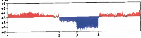
An example of these differences is shown in Figure 3wherean infrared image of a bridge is displayed. It is easy to see that the material and the absence of a substrate
[image:17.595.276.524.484.551.2]have influence on the bridge’s temperature. This is an important factor to take into account, because it means that authorities in the field of winter maintenance should take the various circumstances and temperatures in the road network into account. These differences are greatest during cold and clear nights, because heat radiating from the road is largest under those circumstances (CROW, 2008). In this context, Twente Milieu pays extra attention to, so called, critical locations in their snow
9
and ice control program. Such locations are not always the coldest, because also the availability of moisture is of importance.
2.1.2 Types of slipperiness
Slipperiness can occur because of freezing of the water on the road surface (called ‘black ice’), condensation of moisture from the air, or precipitation.
Black ice is considered very dangerous, because road users can barely see the difference between a wet road surface and a frozen road surface. For this reason, drivers not always adjust their driving behavior.
Condensation occurs when moisture from the air is deposited on the road surface. If the road temperature is lower than the dew point this will result in a wet road surface that eventually could become black ice.
Precipitation (snow, glazed frost, and hail) is the most common cause of slipperiness. The form of precipitation has major influence on the behavior of drivers, therefore on the chance of accidents. For example, snow is easily observed and this generally results in traffic participants adjusting their driving behavior.
2.1.3 Types of pavement
As already stated, the pavement is of influence on the temperature, however it also influences the most effective way (timing of salting, frequency, dosage of salt, technique) to fight slipperiness. The following sections all cover different types of pavement and their reaction on winter conditions. Dense asphalt concrete and stone mastic asphalt
Dense asphalt concrete and stone mastic asphalt both have a rather dense structure on the top. This makes it quite easy to fight slipperiness. However, in the presence of
ruts, see Figure 4, water cannot easily flow to the side of the road. This increases the chance of slipperiness.
Open asphalt concrete (‘ZOAB’)
Open asphalt concrete, see Figure 5, is characterized by an open structure on the top. This result in less noise, however the road’s temperature
easily adapts to the temperature of the surroundings. If temperature drops, open asphalt gets slippery easily. Furthermore, a proportion of the thawing material gets into the pores of the open asphalt reducing the effect of the salt. This effect is mitigated when traffic intensity is high. During winter conditions, open asphalt gets salted more often and more salt is sprinkled on the road.
Pavement
Some examples of pavement are tiles, cobble stones or pavers. The pavement is made up of individual elements, see Figure 6, that are more or less loosely connected to each other. It has the same characteristics as open asphalt concrete in the sense that the pavement’s temperature easily adapts to the temperature of the surroundings.
Figure 4: A rut
Figure 6: Individual elements Figure 5: ZOAB
10 Cycle paths
Cycle paths are generally made of pavement or thin asphalt. Due to this structure, its temperature mostly is colder than the main road. Most cycle paths are equipped with cycle tunnels, poles et cetera. This makes salting such paths difficult.
Rail crossing
ProRail’s directive specifies that rail crossings are not being salted. Salt can interfere with the electrical relay that is used for the security of the crossing. Salt spreading stops within 10 meters of the rail crossing to prevent this from happening.
Bridges, overpasses et cetera
As already stated, the material (wood, concrete, metal) of which such a building is made off determines how Twente Milieu should prevent it from being slippery.
2.2 Thawing materials
Thaw refers to the process of melting. The thawing material is the actual component that facilitates this process. In the following sections, the effect of thawing materials is explained as well as which type of thawing material is used mostly and which salting strategies are used.
2.2.1 Freezing-point depression
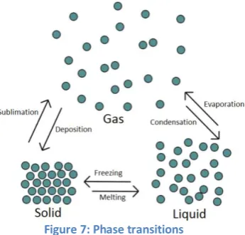
The effect of thawing materials can best be explained by ‘freezing-point depression’ or cryoscopy. It describes the process of the phenomenon that the freezing point of a solution decreases when a solute (for example salt) and a solvent (for example water) are dissolved.
If the water temperature drops below 0° Celsius a state transition from liquid to solid (ice) takes place. As a matter of fact, the molecular structure of, for example, water changes (see Figure 7). If a solute (for example NaCl or salt) is added to water a solution is obtained. The solution consists of water molecules, sodium ions and chloride ions. Now, if temperature drops to 0° Celsius, the water molecules solidify and arrange in a grid. However, the sodium- and chloride ions prevent the water molecules from forming a perfect grid (ice). This means that lowering the freezing point is not about the characteristics of, for example sodium chloride, but about the
amount of parts (ions) that prevent the solvent from forming a grid, thus becoming a solid. Appendix A provides more insight into freezing-point depression.
2.2.2 Types of thawing materials
The choice for the deployment of a thawing material depends on several factors, namely (CROW, 2008):
effectiveness: as a function of melting capacity at a certain temperature, # kg of ice that is melted by 1 kg of thawing material;
[image:19.595.366.539.444.609.2] applicability: the freezing-point depression;
11
availability: the thawing material should be available in a large amount and at a short notice; workability: the material should be easily stored for longer periods without losing its efficacy; safety: no need for safety provision to use the product;
noxiousness: vehicles, roads and the environment are not to be damaged by the product; environmental impact: biological impact on the environment should be minimized; price: the material is used in large amounts this means that the price is important.
Salt is the most common thawing material used in ice and snow control programs. Various types of salt can be used for this purpose. Sodium chloride (NaCl) is the most common used thawing material, however also Magnesium chloride (MgCl2) and Calcium chloride (CaCl2) are used.
Sodium chloride (NaCl)
Two types can be distinguished: vacuum salt and halite (rock salt). Vacuum salt is characterized by high purity and a uniform particle size distribution. Halite has a more coarse grain and mostly is contaminated with sand, heavy metals et cetera (Akzo Nobel). Vacuum salt is, because of the fine grain, in contrast with halite rapidly effective.
2.3 Current decision making process
Understanding the current decision making process and the determination of the salting routes is important, because it functions as the context for the mathematical model, introduced in Chapter 4. This model functions as a tool for the realization of effective and efficient routes. These two subjects are covered in Sections 2.3.1 and 2.3.2. Section 2.3.3 deals with the factors that are important for the decision whether to start salting roads or not. In the last section, some problems arising from the current way of working are being discussed.
2.3.1 Determination of the routes
Twente Milieu identified twenty different routes in Enschede. These routes are set by one of the winter coordinators by dividing the sprinkle map (Appendix B) into different sections. Every section corresponds with a salt spreader. Subsequently, routes are created based on experience, intuition, and logic. Twente Milieu does not use advanced planning techniques. In that sense, it is questionable whether the current routes are optimal or that the use of routing and planning techniques could reduce costs, i.e., minimize kilometers driven.
The twenty routes consist of eleven routes (circa 50 to 60 kilometers per route) that solely consist of motorways and nine routes (circa 30 to 40 kilometers per route) that also consist of cycle paths and smaller roads. As already stated in Section 1.6, this report is about the eleven motorways routes. All routes take approximately 2 to 2.5 hours to complete.
12
snow and ice control. Examining snow and ice control with less salt spreaders will have an effect on road prioritization and vice versa.
2.3.2 Decision making process (on an operational level)
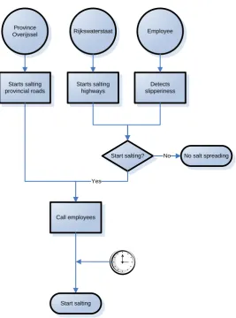
Salting the road network of Enschede can start by three different events, namely: (1) the province Overijssel informs Twente Milieu that it started salting provincial roads, (2) Twente Milieu decides to start the salting operation based on own observations from employees or information provided by MeteoConsult4 (Appendix C) or (3) because Twente Milieu chooses to follow Rijkswaterstaat when they start salting highways.
The salt spreaders usually are operational within 45 minutes after one of these events occurs. This time buffer is particularly relevant during the night, when employees first have to arrive at Twente Milieu. All prescribed routes are salted regardless of whether this is considered effective or not. The salt spreaders continuously work until the roads are safe.
[image:21.595.165.433.306.667.2]This decision making process is depicted in Figure 8.
Figure 8: Operational decision making process
4
MeteoConsult is part of MeteoGroup, the largest private sector weather business. MeteoConsult provides Twente Milieu with information about road conditions on a daily bases. Appendix B gives an overview of the information that is provided.
Rijkswaterstaat
Start salting? Employee
Starts salting provincial roads
Detects slipperiness
No salt spreading No
Yes
Call employees
Start salting Province
Overijssel
13
2.3.3 Important factors
The decision regarding the start of the salting operation, regardless whether it is based on own observations or information provided by MeteoConsult, is based on the weather conditions and timing. Important factors are: expected type of precipitation, expected traffic intensity and the current time. For example: deicing on a Monday at 2 AM has major impact on the employees due to the fact that their night’s rest is split in two (before the work shift and between the end of the work shift and the new work day that starts at 7:30 AM). Furthermore, the low traffic intensity at 2 AM impedes the working of salt on the road.
Another important factor is related to liability. Twente Milieu is, through the Wegenwet, responsible for winter maintenance. Twente Milieu has a so called inspanningsverplichting5, this is in contrast with a resultaatsverplichting6 (CROW, 2008). This means that Twente Milieu is obligated to do its utmost best to keep the roads from being slippery. It is allowed to give certain roads priority based on economical or environmental factors, however such decisions should be in line with applicable standards. This means that the snow and ice control program should be in accordance with recognized standards, otherwise there is a chance that Twente Milieu will be held responsible for damage suffered by road users.
2.4 Conclusion
This chapter was about the first sub question, namely: How is the snow and ice control program currently organized at Twente Milieu? In order to answer this question, several subjects in the context of the ice and snow control program were discussed. This gives an idea about the effects of temperature and precipitation on different kinds of pavement. Furthermore, the current decision making process regarding winter maintenance and the resulting shortcomings are discussed. The following list summarizes these shortcomings regarding the current ice and snow control program:
Twente Milieu is, due to the absence of sophisticated planning tools, currently not able to determine the effects of modifications in the sprinkle map, changes in policy or other adjustments.
Currently, only two scenarios are being considered: salt all routes or salt nothing. This decision is made regardless of the question whether salting every road is effective. For example: during a non-stop snowstorm of 30 hours it is rather questionable if a continuous salting action is effective.
The decision to start all salting operations is not subject to strict guidelines, rather based on (subjective) observations in combination with experience.
It is questionable whether the current way of working and expected cutbacks from the city of Enschede suit each other.
The current routes were established without the use of planning and/or routing techniques, therefore it is questionable whether these are most efficient given the sprinkle map.
Every municipality has its own salting routes. This is in contrast with the objectives, seeking collaboration between shareholders, posed when Twente Milieu was established. This problem lies outside the scope of this research.
5
An obligation to guarantee best efforts.
14
15
Chapter 3: Literature review
In this chapter, an overview of the existing literature in the field of routing problems is presented. The review helps with getting insights into different types of routing models. Section 3.1 gives an overview of the set of generalized routing models. Subsequently, in Section 3.2, difficulties with these models are discussed. This section also covers ways to overcome these difficulties. Section 3.3 is about how literature prescribes the characteristics of good routes. In the last section the conclusion regarding this literature review is given.
3.1 Routing problems
Much has been written about routing problems. Two types of routing problems are distinguished: node routing and arc routing. The first type is about travelling from node (e.g., city or intersection) to node with respect to some objective (e.g., minimizing total travelled distance or minimize total costs). Two well-known problems within this class are the Travelling Salesman Problem (TSP) and the Vehicle Routing Problem (VRP). Such kinds of problems are not being addressed in this thesis, because the snow and ice control program is about servicing streets (arcs), not nodes. Thus, the problem Twente Milieu faces can be classified as an arc routing problem.
3.1.1 Arc routing problems
Arc routing problems are generally about servicing (salting, sweeping, plowing, et cetera) a set R of required edges or arcs in an underlying network 𝐺 = (𝑉, 𝐴 ∪ 𝐸) with nodes V, directed arcs A and undirected edges E as presented in Figure 9 (Assad & Golden, 1995).
The graph could consist of arcs and/or edges. The cost of traversing and servicing an arc (or edge) plays an important role in this class of problems. Typically, objectives of solving such problems are: minimize the sum of the costs of traversing non-required edges or minimize the total costs of servicing all required edges.
The network 𝐺 = (𝑉, 𝐴 ∪ 𝐸)can be seen as a general representation of all arc routing problems. Assad & Golden (1995) presented Table 5in order to summarize some important features of well-known arc routing problems. These problems differ in underlying graph and the required set R.
Problem A E Required edges R Complexity Comments
Undirected Postman Problem (UPP)
𝜙 * R = E P Solved by matching algorithm in
O(n3) or less
Directed Postman Problem (DPP)
* 𝜙 R = A P Solved by flow problem in O(n3)
Mixed Postman Problem (MPP)
* * R = 𝐴 ∪ 𝐸,
𝐴 ≠ 𝜙, 𝐵 ≠ 𝜙 NPC Remains NP-complete even if all edge costs are equal; solvable if G is an even connected graph
Rural Postman Problem (RPP)
𝜙 * R ⊂ E NPC Solvable if GR is connected
Directed Rural Postman Problem (DRPP)
[image:24.595.66.529.583.766.2]* 𝜙 R ⊂ A NPC Solvable if GR is connected
Figure 9: difference between arc and edge
Node Node
Node Node
Arc (directed)
16
Stacker Crane Problem (SCP)
* * R = A NPC Remains NP-complete even if all edge costs are equal
Windy Postman Problem (WPP)
𝜙 * R = E NPC Edge costs depend on direction
of traversal; solvable if G is connected and even
Capacitated Arc Routing Problem (CARP)
𝜙 * R ⊂ E NPC Explicitly capacity constraint on each cycle with respect to edge demands (as in VRP)
Capacitated Postman Problem (CAPP)
𝜙 * R=E NPC Same as the CARP but all edges
must be services
Table5: Overview of arc routing problems. Explanation: * = arbitrary set, P = polynomial time, NPC = NP complete, n = number of nodes, GR = set of required edges.
Many real routing problems can be transformed into one of these more standard problems that have a corresponding integer linear programming (ILP) formulation. Linear programming seeks to achieve a best outcome (i.e., minimizing costs) in a mathematical model whose requirements are presented by linear relationships. Using literature in this field is useful, because much research already has been conducted regarding these problems. They have been studied in the area of ILP modeling and the construction of various types of heuristics. One needs to make a set of assumptions in order to translate the actual problem into one from Table 5. Now, the ILP models and heuristics that correspond to the standard problem can be applied in order to generate a solution. Obviously, it should be checked whether the obtained solution holds in reality with respect to the underlying set of assumptions.
3.1.2 Types of arc routing problems
The Undirected-, Directed-, and Mixed Postman Problem (UPP, DPP and MPP)
An example of the UPP and the DPP is a mailman who visits the post office in order to collect mail and subsequently must traverse every street in order to deliver the mail. Eventually, the mailman returns to the post office (Edmonds & Johnson, 1973). The UPP and the DPP seek to find an optimal route; objective is to minimize total distance covered. The mixed postman problem is a combination of these two problems; the road network consists of roads where both unidirectional (arc) and bi-directional (edge) traffic is allowed.
The (Directed) Rural Postman Problem (D)RPP
These problems can be seen as a practical extension of the previous problems. Here, a subset of the arcs/edges needs to be served instead of all.
Stacker Crane Problem (SCP)
Consider a stacker crane that must load containers into a ship. The capacity of such a crane is one (only one container can be lifted at a time). Given the locations of the containers (demand), a route can be constructed.
Windy Postman Problem (WPP)
Again, consider the postman problem as addressed earlier. Now, the cost of traversing an arc depends on direction of crossing the arc (with or against the wind). More precisely, cost cij and cji
17
Capacitated Arc Routing Problem (CARP) and the Capacitated Postman Problem (CAPP)
This problem has similarities with the RPP. However, this set of problems takes a truck’s capacity into account. This makes the problem much harder to solve. The CAPP differs from the CARP in the sense that the CAPP requires all edges to be served, while the CARP requires a subset of E to be served.
3.1.3 Types of objective functions
The different models also vary in terms of their objective function. Three different categories are distinguished, namely, profitable problems, orienteering problems, and prize-collection problems (Benavent, Corberán, Gouveia, Mourão, & Pinto, 2013). Profitable problems are about finding a route in which the difference between the total collected profit and the distance travelled in maximized. In the second case, the objective function is about maximizing the collected profit with a constraint that arranges for the maximum costs (for example distance covered) does not exceed a certain limit. Prize-collection problems are about looking for a route with minimum costs at a least given amount of profit.
3.2 Subtour elimination constraints
All models above need subtour elimination constraints to make the model feasible. However, such constraints make the model hard to solve. In Section 3.2.1 this set of constraints is discussed. In Section 3.2.2some heuristics are presented that could solve the problem. Section 3.2.3 is about an alternative way to deal with this set of constraints.
3.2.1 Subtour elimination difficulties
The goal of the ILP, cost minimization, presents a solution in which all arcs that need to be serviced are traversed. Furthermore, so called flow constraints force the construction of a route (leaving a node/arc corresponds with entering a node/arc). This can be seen in Figure 10. Due to the model’s goal, the required traversal of intermediate arcs is
omitted resulting in an infeasible solution. This phenomenon is similar to teleporting which is obviously not possible. Subtour elimination constraints prevent this from happening.
Subtour elimination brings in a new problem, namely the excessive computing power needed
to solve the related extensive set of constraints. The number of constraints increases exponentially with the number of nodes (Golden & Wong, 1981). As a result, most problems have too many restrictions in order to be solved. Therefore, it is not uncommon to use heuristics instead of an ILP model to solve problems.
3.2.2 A stepwise subtour elimination restriction
An alternative way of modeling the subtour elimination problem is by introducing the concept of steps. This idea is derived from a helicopter position paper (Van Urk, 2012). In this paper, the next position of a helicopter depends on the current location and intermediate elapsed time. This idea can be translated to the current problem. However, unlike a helicopter a truck depends on existing infrastructure. Such a step is similar with visiting train stations. For example, from station Enschede Drienerlo only the stations Enschede and Hengelo can be visited in one ‘step’. The road map of Enschede can be translated in such ‘stations’ as well. Subsequently, a restriction needs to be drawn
18
that forces the model to add arcs (stations) in the route that are adjacent to the last arc (station) in the route. The idea is basically to construct a closed tour that starts and ends at a depot. Every next street in the tour can be selected out of a set of streets that are reachable in one step from the current position of the truck. This prevents, so called, teleportation or the phenomena that a truck is at two different locations at the same time. In essence, this stepwise approach is not the same as the classical subtour elimination constraints, but rather a method to cope with the same problem, namely disconnected tours.
This idea is also used in a PhD report on movements in civil airspace (Persiani, 2011).
3.3 Heuristics
Due to the complexity involved with solving routing problems many researchers use heuristics. These heuristics can have different starting points. Some start with a feasible solution and work towards a better solution while making improvements. Other heuristics start with adding an arc to the solution, based on a certain criterion, until all arcs are serviced.
Golden & Wong constructed a heuristic for the CARP of the first type. There are many other heuristics. Advantages of these heuristics are that they have been proven in different cases and that they find feasible near-optimal solutions in polynomial time, thus can be used in the case of Twente Milieu. Disadvantages are that the heuristics cannot be used immediately in the case of Twente Milieu, because some characteristics are neglected. For instance, prioritization is mostly not incorporated. Some research has been conducted regarding road prioritization (Demodaran, Krishnamurthi, & Srihari, 2008). However, such heuristics neglect other important features, such as capacity restrictions. No heuristic has been found that dealt with both the capacity restrictions and prioritization of arcs/edges.
To overcome the disadvantages of both solving techniques a combination can be used. As the number of variables and constraints increases exponentially with the amount of nodes/arcs in the network it would help to reduce this amount.
3.4 Conclusion
19
Chapter 4: Model setup
In Section 4.1, the problem of Twente Milieu is being translated into one of the generalized problems from the previous chapter. Furthermore, a set of assumptions is presented in Section 4.2. Model characteristics are covered in Section 4.3. The mathematical model is presented in Section 4.4. Subsequently, Section 4.5 is about problems that arise from this formulation and how these can be tackled. Section 4.6 clarifies the solution method that is applicable to the snow and ice control program at Twente Milieu. Finally, in Section 4.6, is about initializing the parameters.
4.1 Twente Milieu’s arc routing problem
This section is about translating the problem Twente Milieu faces into one of the generalized models. In Section 4.1.1 the characteristics of the snow and ice control program, in the context of arc routing, are explained. Section 4.1.2 is about a corresponding generalized arc routing problem.
4.1.1 Characteristics of the snow and ice control program
The problem can be seen as follows: the trucks of Twente Milieu traverse arcs/edges (roads) in order to serve (salt) them (R ⊂ 𝐴 ∪ 𝐸). Vehicle capacity may not be exceeded, for example, total ‘demand’ of salt of all arcs/edges within a route may not exceed a vehicle’s salt capacity. Furthermore, costs (kilometers driven, vehicles (drivers) used and salt used) are minimized. However, some extra constraints should be incorporated for the model to be applicable on Twente Milieu, namely: (1) some arcs/edges need to be served within 3 hours (phase 1) and some arcs within 5 hours (phase 2), (2) Some arcs/edges should be served more than once due to their width, and (3) traffic regulation should be taken into account.
This problem can be translated into a corresponding ILP problem. As stated in Section 3.1.1, (Integer) Linear programming seeks to achieve a best outcome (i.e., minimizing costs) in a mathematical model whose requirements are presented by linear relationships. In the case of winter maintenance, one could construct an objective in which the total kilometers driven by all trucks are minimized. The ILP seeks to achieve a best outcome while respecting several linear constraints such as, completion time of roads in phase 1 may not be exceeded, truck capacity should be respected, et cetera. Section 4.4 is about an ILP that captures all relevant factors associated with the snow and ice control program at Twente Milieu.
4.1.2 Translating the problem
The problem shows similarities with the MPP (see Section 3.1). However, the MPP lacks capacity (and time) constraints and requires the traversal of all arcs and/or edges instead of a predefined set R. When associated heuristics or ILP restrictions are used, adjustments in the sprinkle map (Appendix A) need to be made. The solution’s quality heavily depends on the adjustments made in the sprinkle map.
20
certainly not for all roads. This means that, after the partitioning and route construction, one should check whether the routes are still feasible due to this assumption. At the moment, this is not a problem, due to the fact that information on a tactical level must be provided instead of operational routes.
As explained in Chapter 3, both heuristics and ILP models can be used to solve the problem Twente Milieu faces. This research is about using an ILP model that captures all elements. Both elements from the MPP and the CARP are used in this model. An ILP is used instead of a heuristic, because ILPs provide an exact solution while a heuristic seeks for an approximation.
4.2 Set of assumptions
The routing problem that arises from the salting activities at Twente Milieu (Section 4.1) cannot directly be translated into one of the problems shown in Table 4 (Section 1.4). First, some assumptions need to be made. From the perspective of delivering insights on a tactical level, it is allowed to make an extensive set of assumptions. Some assumptions do not have an effect on the amount of kilometers driven, however, some assumption do have an effect on the routes.
Assumptions
only one type of salt is used;
only fixed costs for salt storage are taken into account, not variable; there is enough salt present during winters;
not all roads are taken into account. See Section 4.3.3;
depreciation cost, based on mileage and driven kilometers, is excluded; all routes begin and end at the same depot;
arcs are traversed completely or not;
the speed of the salt spreader is always the same and is independent of driving or salting; only personnel costs that can directly be linked to salting are taken into account (no
consignation costs, planning et cetera);
the number of employees used for the salting operation equals the number of trucks used plus an addition of two employees;
the model does not take into account that traversing an already served arc is safer than traversing one that still needs to be served;
traffic regulations (one-way street, turn right/left is forbidden) are not taken into account; a road can be salted from both directions;
fuel restriction is neglected7;
amount of salt sprinkled per arc only depends on the length of the arc, not the width.
4.3 Model characteristics
Before the ILP model can be presented, model characteristics should be clarified. Several characteristics are distinguished. Section 4.3.1 is about dealing with nodes and arcs. Subsequently, in Section 4.3.2, the road network is treated followed by the arc network in Section 4.3.3 and the arc distances in Section 4.3.4.
21
4.3.1 Nodes and arcs
The number of constraints increases exponentially with the number of nodes (Golden & Wong, 1981) (Section 3.2.1). One way to decrease this number of constraints is to swap the nodes and arcs. This can be illustrated as follows. In the case of arcs, let Xikt be one if location (i ∈I), an arc, is being
traversed by truck (k ∈ K) at time interval (t ∈ T). In the case of nodes, let Xijkt be one if truck (k ∈ K)
traverses between node (i ∈I) and node (j ∈I) during time interval (t ∈ T). It can be seen that in the latter case an extra index is used. This extra index causes increased complexity and requires excessive computational power.
A depot location is by definition a node, however if arcs are used instead of nodes the depot location must be replaced by an arc as well. The depot location is represented by an arc with a small distance.
Stepwise approach
The closed tour constraints make use of steps. Within one step a truck may only reach an adjacent arc to the arc it is in now. This is explained in Figure 11. This figure contains a portion of the road map of Enschede. Intersections function as nodes and an arc consists of two nodes. By introducing a parameter it becomes clear whether two arcs are adjacent or not. An arc is adjacent if and only if a common node is shared. For example (see Figure 11): node 1 and 2 are connected by arc C and this arc is adjacent with and reachable from arc A in one step. On the contrary, this does not hold for arcs B
and C. The whole road map is translated into such a set of arcs with an accompanying set of parameters that provides information regarding the contiguity of arcs that can be reached within one step.
Introducing the corresponding constraint that ensures closed tours (Section 3.2.3) clarifies this. The first formula represents the case in which nodes are used, the second formulation uses arcs instead of nodes.
𝑋𝑖𝑗𝑘𝑡 ≤ 𝑋𝑎𝑖𝑘𝑡 −1 ∀𝑖, 𝑗, 𝑘, 𝑡 𝑎∈Aij=1
𝑋𝑖𝑘𝑡 ≤ 𝑋𝑗 ,𝑘,𝑡−1 ∀𝑖, 𝑘, 𝑡 𝑗 ∈Aij=1
Set Aij contains information on the accessibility from one arc to another arc in one time interval. This
accessibility is explained by Figure 11. Furthermore, index a also represents the nodes. It can be seen that using arcs as a starting point instead of nodes drastically decreases the number of constraints required for the closed tours.
4.3.2 The road network
[image:30.595.314.527.267.442.2]Obviously, all roads marked on the sprinkle map need to be traversed. However, salt spreaders might also use other roads in order to drive an efficient and continuous route. In order to reduce computational complexity, the mathematical model will not consider all roads within the city of Enschede. A subset of this extensive class of roads is determined based on the following rules:
22 all roads marked on the sprinkle map;
all roads with a speed limit of at least 50 kilometers per hour that can (visually) contribute to effective routes;
all road segments where the speed limit is at least 50 kilometers per hour, that have a temporary lower speed limit due to particular circumstances (i.e., the presence of a school); roads that are required to make the arc network connected.
4.3.3 The arc network
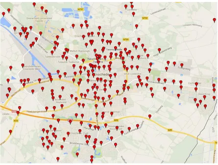
The network that is used is presented in Figure 12. All red dots represent an intersection (node). The coordinates of the nodes are retrieved with GPS Visualizer. Subsequently, these coordinates can be translated into corresponding X- and Y-values (or: Rijksdriehoekstelsel) such that they can be depicted on a map.
[image:31.595.76.522.364.700.2]The Rijkshoeksdriehoekstelsel is a coordination system for the Netherlands. The origin is located in Amersfoort, Onze Lieve Vrouwetoren. The conversion method translates GPS coordinates, which are based on a sphere, into corresponding X- and Y-values which are based on a plain surface area. The method of Schreutelkamp & Strang van Hees (2001) will be used for this transformation. The method has a maximum error margin of two meters (Schreutelkamp & Strang van Hees, 2001), which is sufficient.
Figure 12: Node network of Enschede (GPS Visualizer)
23
4.3.4 Arc distances
[image:32.595.119.464.238.355.2]Mostly, researchers do not use network distance (or: ‘real’ distances) while conducting research in the area of routing. Retrieving network distances for an entire arc network takes quite some time. Euclidean distances tend to be used instead of network distances due to the previous reason, for simplicity, and based on the assumption that the difference between these distances tend to be a constant (or: circuity factor) (Levinson & El-Geneidy, 2007). Multiplying this circuity factor with the Euclidean distance provides an estimate for the network distance. This assumption only holds when variation in the network is minimal. Since nearly all arcs are located in an urban area, the assumption holds for the network of Enschede. Figure 13 gives a visual explanation on the difference between Euclidean and network distances.
Figure 13: Difference between Euclidean distance and network distance (Levinson & El-Geneidy, 2007)
Much research has been conducted to determine the circuity factor. Levinson & El-Geneidy calculated this constant and found a circuity factor of 1.20. The X- and Y-values from all intersections from Figure 13 and the circuity factor of 1.20 can be used to estimate the network distance of each arc based on the coordinates of the two nodes that construct the arc.
4.4 The ILP model
This section is about the ILP used in order to generate routes for the trucks. As already stated in Section 1.6, routes that consist of cycle paths are outside the scope of this report. However, for the sake of completeness, the model also incorporates different types of streets and different types of salt spreaders. When the model is solved, cycle paths with corresponding salt spreaders are excluded.
First, all decision variables, parameters and indices are explained. Next, the objective function and the constraints will be elaborated on. The location represented by an arc (i ∈I) of a truck (k ∈ K) at time interval (t ∈ T) is represented by the binary decision variable Rikt. The binary decision variable Xikt
has the same characteristics, but describes whether a location is salted by a certain truck at a certain time interval or not. The set Aij captures the possibility to travel from arc i to arc j in one time