INTERNAL DOCUMENT
I .
A SEISMIC REFRACTION AND REFLECTION STUDY OF CONTINENT-OCEAN TRANSITION BENEATH THE
NORTH BISCAY MARGIN
F. Avedik, A.L. Camus, A. Ginzburg L. Montadert, D.G. Roberts and R,B. Whitmarsh
Internal Document No, 137
July 1981
[This document should not be cited in a published bibliography, and is supplied for the use of the recipient only].
INSTITUTE OF aCEAIMOGRAPHIC SCIENCES
%
%
INSTITUTE OF OCEANOGRAPHIC SCIENCES
Wormley, Godalming, Surrey GU8 BUB
(042-879-4141)
(Director: Dr. A. S. Laughton)
Bidston Observatory, Birkenhead,
Mersey side L43 7RA (051-653-8633)
(Assistant Director: Dr. D. E. Cartwright)
Crossway, Taunton,
Somerset TA1 2DW (0823-86211)
A SEISMIC REFRACTION AND REFLECTION STUDY OF CONTINENT-OCEAN TRANSITION BENEATH THE
NORTH BISCAY MARGIN
F. Avedik, A.L. Camus, A. Ginzburg L. Montadert, D.G. Roberts and R.B. Whitmarsh
Internal Document No, 137
July 1981 •
Work carried out under contract to the Department .of Energy
(This document should not be cited in a published bibliography, and is supplied for the use of the recipient only).
Institute of Oceanographic Sciences, Brook Road,
VJormley, Godalming,
INTRODUCTION
Theoretical models of lithospheric extension, as well as the
geological consequences of such extension in the form of rifted
cratonic basins and of passive continental margins, have attracted^
considerable recent interest. In the European area, examples of '
rifted cratonic basins include the North Sea (Ziegler, 1978 and
this volume) and the adjacent margins of the North Atlantic Ocean.
It has become clear that extension may also occur in strike slip
and convergent settings (Bally & Snelson, 1979), and examples include
the Western Mediterranean (Biju-Duval et al., 1977) , the Pannonian
Basin (Royden & Sclater, 1981) and the Great Basin (Profett, 1977).
The occurrence of crustal extension, expressed by rifting, in these
different geological settings emphasises that very little is known
of the mechanisms producing the rifting process, including its
initiation, which cause the profound changes in crustal structure
revealed by attenuation and ultimately by the formation of a spreading
ocean basin. . "
Several innovative theoretical models (McKenzie, 1978; Royden et al.,
1980; Royden and Keen, 1980; Sclater & Christie, 1981; Turcotte,
1981) have proposed mechanisms for lithospheric extension and have
attempted to evaluate quantitatively the mechanical and thermal
consequences of each model in terms of histories of margin and basin
subsidence. These models may have a potential practical value in
predicting the thermal history and thus the degree of.hydrocarbon
maturity in sedimentary basins formed in response to a lithospheric
extension (Royden & Keen, 1980; Royden et al., 1980; Sclater & Christie,
1980). However, a rigorous description of the deep crustal
structure beneath a cratonic sedimentary basin or a passive continental
margin that would provide sufficient data to quantify the extension
in order to constrain these models has been lacking as has a comprehensive
study of the geological and thermal history of basins that have evolved
in response to lithospheric extension.
In this paper, we present some of the results of a detail seismic
refraction and reflection study of the northern or Armorican margin
of the Bay of Biscay. The study examined the deep crustal structure
-of the rifted and attenuated continental crust and -of the transition
to the adjoining oceanic crust. It is believed to be the first
time such a detailed seismic description of a rifted passive nargin
has been obtained. A comprehensive discussion of the seismic data
and their interpretation will be published elsewhere (Ginzburg
r
et al., in preparation). /
REGIONAL STRUCTURE OF NORTHERN BISCAY
The continental margin in the Southwestern Approaches to the
English Channel (Figure 1) consists of a broad shelf, a relativ^y
steep slope and a broad rise that merges imperceptibly with the
Biscay Abyssal Plain. The shelf is underlain by the NE-SW trending
Western Approaches Basin which seems to intersect the margin. Further
north, the Cornubian High separates the Western Approaches Basin
from the Celtic Sea Basin (Montadert et al., 1979; Roberts et al. , *
1981).
I
Beneath the slope and rise multichannel seismic reflection
profiles show that the margin consists of thin Tertiary and Cretaceous
sediments that overlie a series of large tilted and rotated fault
blocks. -Rifting apparently took place in Late Jurassic-Early Cretaceous
time in a pre-existing marine basin and was completed by Late Aptian
time (Montadert, Roberts et al., 1977; Montadert et al. , 1979). —The
overall tectonic style consists of tilted and rotated fault blocks
whose downthrow is consistently down toward the ocean. The pattern
of faults is probably en-echelon or anastomosing. Many of the
fault blocks are bounded by listric normal faults (Fig. 2a) with
throws of up to 3000 m. The listric faults flatten out with depth
close to the top of a sub-horizontal group of reflectors called
'S' (Fig. 2b). Comparison with early refraction data suggested that
this reflector corresponded to the boundary between a 4.9 and
6.3 km.sec ^ layer (Avedik & Howard, 1979). De Charpal et al. (1979)
and Montadert et al. (1979) interpreted the 6.3 km. sec ^ refractor
as the boundary between the upper brittle and the lower ductile
continental crust. Refraction data on the shelf (Holder & Bott, 1971)
suggested that the Moho shoaled from 25 km beneath the shelf break
to 12 km near the continent-ocean transition where, from the available
refraction data, the observed ductile crust was estimated to be only 3 km
-in thickness. These early results showed that the observed th-inn-ing
of the crust could not be fully explained by the extension of lO-15%
in the upper crust and resulted in the suggestion that the lower
ductile had thinned by a greater amount (De Charpal et al., 1978;
r
Montadert et al., 1979). The drill, dredge and reflection data /
suggested that at the end of rifting a system of half-graben
about 2.5 km below sea level existed adjacent to the continent-ocean
transition (Montadert, Roberts et al., 1977, 1979). After rifting
regional subsidence took place in response to cooling of the
lithosphere of which the continental crustal part had been thinned
during the rifting process. This interpretation of attenuation
although based on good quality multichannel seismic data, was dependent
on earlier refraction profiles whose directions are now,known to
cross underlying fault blocks.
EXPERIMENTAL DESIGN
1
In June 1979, a number of single ship refraction profiles and
two-ship reflection and refraction profiles were occupied on the
margin. The purpose of the experiment was to define the variation
in the deep structure of the continental crust from beneath the shelf, to
define the continent-ocean transition and to examine the relative amounts
of thinning in the upper and lower parts of the crust. The experiment
was also designed to examine the width and nature of the transition
from continental to oceanic crust.
The study was carried out in two parts. During the first phase
refraction profiles were shot by RRS Shackleton using the Pop-Up
Bottom Seismographs (PUBS) of the Institute of Oceanographic Sciences
(Kirk et al., in preparation) and the Ocean Bottom Seismographs (OBS)
of the Centre Oceanologique de Bretagne (Avedik et al. , 1978) along
the lines shown in Figure 3a. The study area, some 30 km west of
the region studied in detail around Site 400A (Montadert et al. ,
1979), was selected to avoid complications that might be posed by
the prominent uplift associated with Late Eocene-Oligocene shearing
in the vicinity of the Trevelyan escarpment. Line 1 was situated
on the oceanic crust and line 2 on the presumed thinned continental
crust. As far as was possible these lines were oriented parallel
-3-to the continent-ocean transition and in the case of line 2, parallel
to the strike of the tilted blocks. An additional unpublished reversed
refraction line (Fig. 3a) situated on the ocean crust south of line 1 and
made with PUBS (Discovery Station 6737-5739) was reinterpreted and
incorporated in the study. Line 3 consisted of a long refraction r
profile from the ocean crust to the shelf encompassing the continent-ocean
transition and the progressive change from attenuated crust to
thick crust beneath the shelf. PUBS and OBS were deployed at various
points along the line to give a series of overlapping reversed
profiles. The energy source used along lines 1, 2 and 3 was a
4 X lOOO in^ airgun array. Profile 4 along-the shelf was unreversed
and was shot using explosive charges of up to 600 lbs. It was intended
to use explosives along line 3 but this was not possible for reasons
beyond our control.
During the second phase of the experiment (Figure 3b) RRS Shackleton
and the RV Resolution of the Institut Francais du Petrole occupied a
series of two-ship multichannel seismic reflection profiles. RRS Shackleton 3
acted as the shooting ship using a 4 x lOOO in airgun array and
RV Resolution acted as receiving ship using a 2.4 km 48-trace streamer.
Relative positioning was maintained using a PULSE-8 shore based
radio-navigation system (accuracy — 25 m) and radar. Shot breaks were
transmitted froai Shackleton to Resolution using a time break transmitter.
The following types of two-ship profile were made. Along
refraction lines 1 and 2 on either side of the
continent-ocean transition, two-ship expanding spread profiles were made to
ranges of 35 km. In addition, along both these lines and part of line 3,
30 km fixed offset profiles were made; 30 km was chosen as the offset
from a preliminary Moho depth estimate to ensure that only Pn arrivals
would be obtained as first arrivals. Five kilometre fixed offset
reflection profiles were also made along the whole of line 3 and line 4.
Conventional 24-fold 48—trace reflection profiles were also obtained
along all refraction profiles by R.V. Resolution. Bathymetric and
gravity data were acquired on all profiles by RRS Shackleton.
To aid the seismic and gravity modelling, a multichannel seismic
reflection profile extending from the continental shelf to the ocean
migrated by the Institut Francais du Petrole. We discuss below
interpretation of the expanding spread (Camus, 1980) and refraction
data. The fixed offset data have been discussed in part by Camus
(1981) and will be presented in Ginzburg et al. , (in preparation).
EXPANDING SPREAD SEISMIC PROFILES
The principles of two-ship expanding spread seismic reflection
profiling have been discussed by Stoffa and Buhl (1979) and a
detailed discussion of the way in which our data was processed can
be found in Camus (1980) .
y
In this experiment, RRS Shackleton acted as shooting ship using
a 4 X lOOO in^ airgun and R.V. Resolution as receiving ship using
a 48-trace (2400 m) streamer. The time interval between shots was
80 seconds, resulting in a shot to receiver spacing increment of
400 m at a speed over the ground of 5 knots maintained by each
ship. The position of the expanding spread profiles (ESP) on either side
of the continent-ocean transition is shown in Figure 3b. The recorded
data were subjected to wave number and frequency filtering prior to
6-fold stacking to ensure maximum enhancement of signal.
Interpretation of the expanding spread data has been made with
reference to individual shots (48-traces per shot), as well as to the
stacked section.
Individual shots in expanding spread seismic profiles
The slope(s) and intercept's) of refracted arrivals were measured
for each individual shot. This method was used to take advantage
of the precision with which slopes could be measured. The multiple
measurements of velocities along the line were used to assess
variations in apparent velocity within a given layer. Examples
of some traces displayed using different reduction velocities
are shown in Figure 4.
The range of apparent velocities and intercept times are tabulated
below.
-5-TABLE 1
Apparent velocity and intercept data (individual shots) expanding spread
lines 1 and 2
Line 1 (oceanic crust)
- 1
Velocity (km.sec ) Intercept (sees)
From TO From To
Line 2 (thinned continental crust)
Velocity (km. sec ^ Intercept (sees)
From to From To
2.0
3.65 - 3.8
4 . 4 - 5 . 3 6.5 - 6.8
7.3 - 7.8
6 . 4 - 6 . 7 5 7.6 - 8.4
8.5 - 8.8
9 - 9.3
2.0
3.5 - 3.7
4.5 - 4.7
6.1 - 6.7
8.1 - 8.7
6 . 3 - 6 . 4 7.2 - 7.3
8.1 - 8.4
8.7 - 8.7
In the line 1 (ocean crust) data, the 6.5-6.8 km.sec
come from the top of the oceanic layer 3 and the 7.3-7.8 km.sec
arrivals are from the Moho.
arrivals have - 1
In the line 2 (thinned continental crust) data, the 4,5 to 4.7 km.sec
velocity is a refraction from the top of the tilted blocks. The
6.1-6,7 km.sec ^ refractor is the top of the crystalline basement - 1
- 1
within the tilted blocks and the 8,1-8.7 km.sec
Moho.
refractor is the
In comparing the two lines, the scatter of the intercepts is greater
on line 1 situated on the oceanic crust. Although the scatter may be
due in part to the existence of strong velocity gradients within the
oceanic basement, some of the scatter of velocities and intercepts
on both lines probably results from the oceanic basement topography
on line 1 or the tilted blocks on line 2. For example, a dip of
10° on a 8.2 ki
7.55 km.sec~^.
o — 1
10 on a 8.2 km.sec refractor will reduce the apparent velocity to
Stacked expanding spread data (Figure 5a)
Results from the expanding spread profile along line 2 are
shown in Figure 5a. Each ESP was shot twice, with the two ships
-first approaching and then going away from each other. Intercept
times were measured on both sides of the stacked sections to give
averaged apparent refraction velocities and intercept times (Camus,
1 9 8 0 ) .
The results calculated assuming horizontal layering are given t
in Table II.
TABLE II
Line 1 (oceanic crust) from expanding s pread data.
_ 1
Velocity (km.sec ) Velocity Intercept (sees) Depth (km) Accuracy
Depth (km)
1.51
2 . 3 5 4 . 9 5 4.6
3.5 +5% 6 . 6 5 6.1
4 . 8 ±8% 7.8 7.95
6.7 18% 8 . 8 5 10.2
7.8 9.4 12.5
Line 2 (thinned continental crust) from expanding spread data
Velocity (km.sec ^) Velocity Intercept (sees) Depth (km)
- Accuracy
1.51
2.4 4.7 4.52
3.5 l5% 6.4 6.1
4.6 28% 7.3 7.4
6.4 ^8% 8.25 9.2
8 . 2 8.9 11.2
Using these results, travel-time curves for lines 1 and 2 have been
calculated and both the refracted and reflected branches are in good
agreement with the observed travel-time data (Figure 5b) (Camus, 1980) ,
SEISMIC REFRACTION PROFILES
Seismic refraction profiles were occupied along lines 1, 2, 3 and 4'
using PUBS and 03S. Data were recorded in analogue form in the PUBS
and by pulse-coded modulation on the OBS. A 4 x 1000 in^ airguii array
firing every two minutes at 2000 psi was used as the sound source
on lines 1, 2 and 3. Line 4 was shot using explosive charges of
25 lbs for the near shots and 300 or 600 lbs for the far shots.
Ranges were conputed for each trace for the PUBS data and every
15 shots for the OSS by computer modelling of water-wave travel-times.
Sound speeds in the sea down to 2000m were obtained from velocimeter
data (ICS unpublished data) and to greater depths from Fanner and
Bucca (1971).
The PUBS data were digitised at 100 samples per second and the
digitized data were plotted as filtered reduced travel-time record
sections. Because of the low signal to noise ratio, particularly
at ranges greater than 15 km from the PUBS, three trace running
averages were applied to the PUBS traces and the averaged sections
were used for picking arrival times. The OBS data were displayed
as unreduced, unaveraged variable area record sections on which •
apparent velocities, but not arrival onsets could be read with
confidence.
In interpreting the data, a preliminary model was constructed
based on estimates of true velocities from updip and downdip
apparent velocities and from depths calculated by standard velocity
intercept methods. This model was then input into a two-dimensional
ray tracing programme (Makris, 1977) which was used to develop the
final models. A timing correction was applied to all the arrival
times to extend the ray paths to the sea-surface vertically above
the PUBS and OBS. The correction was based on a refraction velocity
of 8 km.s Errors in this assumption will only be significant
for arrivals from the uppermost crust not studied in detail here.
For Station 6739, amplitudes were modelled using synthetic seismograms
computed by the Fuchs and Muller (1971) reflectivity
method to estimate gradients within the oceanic crust (Figure 6).
In addition, the models were constrained by thickness and interval
velocity data for the upper sedimentary layers computed from the
multichannel seismic lines and, where available, from the expanding
spread refraction data.
Refraction line 1 (oceanic crust)
An OBS was deployed at each end of line 1 and a PUBS in the centre.
-Although refracted arrivals do not persist over distances greater
than 35-40 km from the OBS, a reversed refraction profile was
thus obtained (Figure 3a, 7). Calculated velocities are 2.35 and
3.32 km.s ^ (sediments), 4.44 km.s ^ (layer 2), 6.6 km.s"^ (layer 3)
and 7.9 km.s"^ (upper mantle). These velocities are in good agreement
with those calculated for lines 6737 and 5739 some 30 km south of -1
line 1. The 4.44 km. sec refractor corresponds to the 3.5 and
4.8 km.sec"^ refractors observed on the unreversed ESP line 1 (Table II)
The existence of velocity gradients was deduced from the 6737 and 6739
data and is confirmed on line 1 by the concentration of energy near
the 6.7-6.9 km.sec"^ crossover distance in the PUBS data. The
_ , w
thicknesses of the various layers are: sediments 2.6 to 3.0 kms,
layer 2 1.6km, layer 3 varied from 2.4 km in the west to 2 km in the
east (Figure 7). The model calculations were based on the arrival
times and apparent velocities obtained for the PUBS data because
of the poor quality of the OBS data on this line. j.
Refraction line 2 (thinned continental crust)
Two PUBS deployed at each end of the line (Figure 3a) yielded
record sections which have been used to calculate the model in
Figure 8. The velocities in this model are 3.43 km.s"^ for the
second sediment layer, 4.52 km.s ^ (Palaeozoic or Mesozoic? sediments),
6.2 km.sec"^ (crystalline basement) and 8.05 km.s~^ (upper mantle).
The 6.2 km.s ^ layer is 2.5 to 3.0 km thick and dips gently westward
as does the Moho. The configuration of the interfaces above the
crystalline basement was obtained from the multichannel reflection
profiles.
Refraction profile 3
Refraction profile 3 (Figure 3a) extends across the entire margin
from the shelf to the Biscay Abyssal Plain. The profile was designed
to examine the thinning of the continental crust as well as the
transition from thinned continental crust to oceanic crust. The
profile connects the two transverse refraction profiles discussed
-9-above and profile 4. Three PUBS and three OBS were deployed along the line
(Figure 3a) . Although it was originally intended to use explosive
charges to obtain good arrivals at long ranges, this proved impossible
and the airgun array was perforce used, thereby severely limiting the
quality of the data. r
The velocity structure used to constrain the refraction models at
the south end of line 3 is derived from the reversed refraction
profiles 1 and 2. After allowing for variations in sediment thickness
obtained from multichannel seismic profiles along line 3 (lines IFP-3 and
IOS CM-14, Figure 3b) all variations in apparent velocity have been
attributed to dip variations and not to lateral velocity variations
within layers. Each reversed refraction profile between adjacent
PUBS or OBS along line 3 was interpreted independently to obtain a
section by section model for the whole line.
PUBS 4 was located on oceanic crust at the southern end of line 3
(Figure 3a). The split refraction profile recorded by this ,
PUBS covers the segment of line 3 from just south of line 2
to the southern end of the line. The velocity distribution used
in computing the model was that of line 1. The segment of the split
profile south of PUBS 4 is shown in Figure 9. Layer 3 apparently
thins southward from 3 km to 2.5 km.
The next segment of line 3 was recorded from PUBS 2 situated on
thinned continental crust 15 km north of refraction profile 2 (Figure 3a).
Readable arrivals were observed to a range of 30 km to the south of
PUBS 2 (Figure 10) . Four distinct arrivals are present and correspond
to the 3.43 km.s " and 4.52 km.s~^ sedimentary layers, the 6.2 km.s~l
crystalline basement and the Moho. North of PUBS 2, however, arrivals
were recorded only out to a range of 25 km and the Pn arrivals were
thus not observed. However, the Pg arrivals define the configuration
of the crystalline basement. The velocity distribution used in the
models is derived from refraction line 2.
The results of modelling the refraction profiles from PUBS 2 and 4
provide some constraint on the position of the continent-ocean,boundary.
Modelling of the observations made at PUBS 2, using the velocity
distribution calculated for refraction profile 2, gave good agreement
lO-between calculation and observation. However, use of the velocity
distribution obtained for line 1 situated on ocean crust did not
give good agreement. The converse was found in attempting to apply
the results of refraction line 1 to the data obtained at PUBS 2,
The discrepancy indicates that a major lateral change in crustal
structure, here interpreted as the continent-ocean transition, is
present within the region between PUBS 2 and PUBS 4 and probably
is located between PUBS 4 and refraction profile 2 (Figure 3a) .
The record section south of OBS JULIE (Figure 3a) has been modelled
using the results from PUBS 2, refraction line 2, and the multichannel
reflection profiles IFP-3 and IOS CM-14. The signal to noise ratio
of the record section is low and it is fairly certain that picks at
ranges over SCkm do not represent the onset of the event. Nonetheless,
the model, which is fairly well constrained by the above data shows the
progressive thickening of the crust, and particularly the lower crust,
towards the shelf (Figure 11). Unfortunately, because of the poor quality
of the data, P* and PIP arrivals could not be identified in the later
arrivals so that the position of the discontinuity between the upper and
lower crust and its behaviour in relation to the crustal thickening could
not be determined.
Refraction profile 4 ~
The refraction profile 4 (Figures 3a, 12) is unreversed and was shot on
the shelf across line 3 using explosives. No reflection data were available
along this line and there is thus very little control on the depth and
attitude of the sedimentary layers. However, a prominent basement high
is evident from travel times. To satisfy the observed travel-time of
the PmP reflection, it has been necessary to somewhat arbitrarily divide
the crust into an upper layer with a velocity gradient from 6.2 km. s ^
at the top to 6.4 km. s ^ at the base and a lower crustal layer with
velocities ranging from 6.4 km.s"^ at the top to 5.7 km.s""^ at the
base.
SURVEY OF THE REFRACTION INTERPRETATION
A summary true-scale section of the distribution of the principal
-refracting interfaces along line 3 is shown in Figure 13 together
with the positions of the OBS and PUBS. Depths of the interfaces
have been interpolated between OBS JULIE on line 3 and line 4 on the
shelf. Uncertainties in the data are shown by dashed lines. The
continent-ocean transition is inferred to lie within a narrow 8-lOkm ?*
/
wide zone immediately south of refraction profile 2 from the following
three lines of evidence. Firstly, ray trace modelling of crustal
structure south of PUBS 4 made using the velocity distribution determined
for the thinned continental crust along line 2 does not provide satisfactory
agreement with the observed refracted arrivals. This indicates that the
transition must occur north of PUBS 4 and south of refraction line 2
and PUBS 2. Secondly, the position of the transition in this region
is independently suggested by the marked difference in the velocity
gradients observed in the basement along lines 1 and 2. Thirdly, the
refracted arrivals observed on the 30 km fixed offset profile recorded
along the southern part of line 3 also show a significant change in this
region. South of the inferred transition, only mantle arrivals were
observed but to the north arrivals from both basement and mantle are
present. A distinct zone of about lOkm width from v/hich no arrivals
were recorded coincides with the transition zone identified from the
above data (Camus, 1981).
The composite profile has a number of interesting features which will
be noted here and discussed in more detail in the conclusions. Mo ho.
depths are very similar on either side of the transition but mantle
velocities are different (c.f. 8.05 and 7.9 km.s ). Within the
continental crust, the 4.52 km.s"^ layer remains relatively constant in
thickness in contrast to the underlying crystalline basement which
thickens from 3 to 12 km progressively toward the continent.
GRAVITY MODELS
Although the refraction data provided a very good description of the
variation in crustal structure across the entire margin, the absence
of information on the behaviour of the upper crust/lower crust boundary,
as revealed near the foot of the slope by the 'S reflector' on
multichannel seismic profiles, was particularly disappointing. As an
-alternative approach, an attempt was made to model the observed
gravity profile using the results from the refraction experiment.
Initially density boundaries were not introduced within the
continental crust in order to test the agreement between calculated
and observed free-air gravity anomalies using the refraction data
alone. Interfaces were taken directly from the seismic models and
the continent-ocean boundary was positioned from the criteria
discussed above. Sediment densities were picked from figures in '
Hamilton (1978), continental crustal densities from the Nafe-Drake (1963)
curve, oceanic crustal densities from Christensen and Salisbury
(1975) and mantle densities from Christensen (1966). The model
was computed using the two-dimensional method of Talwani et al.
(1959). The results (Figure 14a) show a substantial discrepancy
indicating that greater mass must exist within or beneath the continental
crust with respect to the oceanic crust. This excess can be accounted
for by lateral density variations in the upper mantle and/or within
the lower continental crust. Further modelling showed that the
required density variations in the upper mantle violate the refraction
data and that more reasonable values do not fully account for the
observed mass excess. A third model was computed, using a density •
interface within the crystalline part of the continental crust.
The depth of this interface was arbitrarily chosen to correspond
to the 'S reflector'. A small lateral variation in mantle density
also needed to be included in the model (Figure 14b). Agreement
between calculation and observation is good. In particular, the
model supports substantial oceanward thinning of the lower continental
crust from 7 km to almost zero at about 100 km from the foot of the
slope. Indeed, the possibility that the Moho and the base of the
upper crust (S reflector) are coincident cannot be excluded from the
gravity interpretation. In marked contrast, the upper part of the
crystalline continental crust remains relatively uniform in thickness
between the foot of the slope and the continent-ocean transition.
DISCUSSION AND CONCLUSIONS
The results from the seismic refraction study, multichannel seismic
reflection profiles and gravity modelling have been combined in the
true scale section across the entire north margin of Biscay displayed
in Figure 15. The geometry of the fault blocks has been reconstructed
from migrated seismic sections (linesIFP-13 and IOS CM~14), subsequently
-13-converted to depth using both interval and refraction velocity data.
Depths of the deeper interfaces have been taken from the refraction
models. The position of the ' S reflector' is approximate and has
been computed from interval velocity data in the sedimentary layers
and the 6.2 to 6.4 km. s~^ refraction velocity in the crystalline
basement. ^
The section has several features which have an important bearing
on the problem of the measurement, as well as the mechanism, of
crustal attenuation along rifted margins.
The observed position of the ' S reflector' indicates differential
thinning within the crystalline continental crust toward the
continent-ocean boundary and the gravity model does not exclude
this possibility. The lower crystalline crust thins oceanward
near OBS JULIE and to a value near zero close to the continent-ocean
transition. In this region, the ' S reflector' observed on seismic
profiles may be a complex event arising from the intra-crustal
discontinuity and the immediately subjacent Moho. The section
indicates that the larger part of the lower crust has been lost.
Thinning is also evident in the upper crystalline part of the crust
but in contrast it has a global g value of between 2.5 and 3 from
the shelf to the continent-ocean transition. Over the region of
extreme thinning in the lower crust, the upper crust remains relatively
uniform in thickness. A third estimate of extension can be derived
from the rotation of the tilted blocks. Using a true-scale section
computed from the migrated multichannel seismic profile, the quantity
of extension 3 has been found for the blocks between OBS JULIE and
the continent-ocean transition. Values range between 1.1 and 1.45
and are similar to the range of values computed by Chenet et al.
(in press) but are significantly lower than values of about 3
found for the tilted blocks by Le Pichon and Sibuet (1981 and
this volume).
Estimates of the extension parameter 3 found by Le Pichon and
Sibuet (1980) for the upper crust on the north margin of Biscay have
been interpreted by them in terms of the model of uniform extension
of the whole lithosphere developed by McKenzie (1978). However,
the results of the refraction survey and these calculations indicate
that there has been substantially greater thinning of the lower
-14-crust than the upper. The extension parameter derived for the
tilted blocks is not representative of the overall extension of the
crust as was earlier noted by De Charpal et al. , 1979 and Montadert
at al. (1979). Indeed, according to our results, the global thinning
of the crust (4.8) is much greater than that estimated by Le Pichon
and Sibuet (1981).
r
The difference in the thinning of the upper and lower crust creates
an obvious mass balance problem of some importance in extension
models. One solution is to invoke rift subsidence as a consequence
of a gabbro-eclogite phase transition at the Moho as proposed by
Artyushkov and Sobolev (1981). Another hypothesis is to propose
that extension of the lithosphere, which perhaps had already been*
weakened during a previous rifting in Permo-Triassic time, began by
brittle failure above and ductile failure below the 'S reflector'. As
extension continued, the lower ductile part of the crust became
progressively heated and gradually modified by the addition of new
mantle that effectively converted the lower crust into a modified
upper mantle. The lateral variation in upper mantle density implied
by this hypothesis is also suggested by the best-fitting gravity
model (Figure 14b). Clearly, more work is required to assess lateral
variations in the upper mantle and lower crust in the transition zone.
Continued thinning by brittle and ductile flow with contemporaneous
conversion of the thinned lower crust took place until the thinned
upper crust rested directly on the hot upper mantle. At this stage
when the outer part of the rifted margin had subsided by rifting to
about 2.0 km (Montadert et al. , 1979), the asthensophere might have
been able to break through thus causing the initiation of sea-floor
spreading.
ACKNOWLEDGEMENTS
We wish to acknowledge support for this study from the UK Department
of Energy, the Natural Environment Research Council, the Centre Oceanologique
de Bretagne, the Institut Francais du Petrole, the Centre Nationale pour
1'Exploitation des Oceans and the Comite des Etudes Petrolieres Marins.
The Masters and ships* crews of R.V. Resolution and RRS Shackleton are
thanked for their co-operation. The work could not have been done
without the help of R.E. Kirk, J.J. Langford, P.R. Miles, S. Smith,
-15-G. Aubert, R. Conogan and R. Paron on RRS Shackleton and M. Cassand
on R.V. Resolution. The time break transmitter was kindly loaned
by Socie'tee Nationals des Petroles Aquitaine.
-REFERENCES
Artyushkov, E.V. and Sobolev, S.F. (1981). Origin of Crustal Subsidence
on Passive Margins. Mem. Am Ass. Petrol. Geol. in press.
r
Avedik, F. & Howard, D. (1979). Preliminary results of a seismic
refraction study in the Meriadzek-Trevelyan area, Bay of Biscay.
In: Initial Reports Deep Sea Drilling Project, 48, 1015-1023.
US Government Printing Office.
Avedik, F. , Renard, V., Buisine, D. & Cornic, J-Y. (1978). Ocean
bottom refraction seismograph (OBS). Mar, geophys. Res. ,
3 ( 4 ) , 357-379.
Bally, A.W. & Snelson, S. (1980). Realms of subsidence. Pp 9-94
In: Facts and Principles of World Petroleum Occurrence. Ed.
A.D. Miall. Canad. Soc. Petrol. Geol. Mem. 6. •
Biju-Duval, B. , Dercourt, J. & Pichon, X. Le (1977). From the Tethys
Ocean to the Mediterranean Sea; a plate tectonic model of the
Western Alpine system, pp 143-164 in Structural History of the
Mediterranean Basins. Ed. Biju-Duval, B. & Montadert, L.
Editions Technip, Paris.
Camus, A-L. (1980). Campagne Sismique Refraction marge continentale
Nord Gascogne. Inst. Francais du Petrole Rept. 28 310, 100 pp.
Camus, A-L. (1981) Campagne Sismique Refraction: analyse des
documents 'Distance
Rept. 28 898, 63 pp
documents 'Distance fixe 30 km'. Institut Francais du Petrole
- J
Charpal, 0. de, Guennoc, P., Montadert, L. & Roberts, D.G. (1978).
Rifting, crustal attenuation and subsidence in the Bay of Biscay,
Nature, 275, 706-711.
Chenet, P.Y., Montadert, L., Gairaud, H. and Roberts, D.G. (1981)
in press. Extension rate measurements on the margins of Galicia
and North Biscay: consequences for models of passive margin
evolution. Mem. Amer. Ass. Petrol. Geol.
Christensen, N.I. and Salisbury, M.H. (1975). Structure and constitution
of the lower oceanic crust. Rev. geophys. Space Phy^., 0 ( 1 ) , 57-86.
-17-Christensen, N.I. (1966). Elasticity of ultrabasic rocks,
J. Geophys. Res., 7%, 5921-5931.
Fenner, D. F. & Bucca, P.J. (1971). The sound velocity structure of
the North Atlantic Ocean. US Naval Oceanographic Office Informal
Report No. 71-13, 86 pp.
Fuchs, K. & Muller, G. (1971). Computation of synthetic seismograms
with the reflectivity method and comparison with observations.
Geophys. J. Roy, astr. Soc., 417-433.
Hamilton, E.L. (1978). Sound velocity-density relations in sea-floor
sediments and rocks, J. Acoust. Soc. Amer., 63, 366-377.
Holder, A.P. & Bott, M.H.P., (1971). Crustal structure in the vicinity
of South West England. Geophys. J. Roy, astr. Soc., 23, 465-489.
Kirk, R.E. , Langford, J.J. & Whitmarsh, R.B. (in prep.). A functional a three-component ocean-bottom seismograph for controlled source
and earthquake seismology.
Le Pichon, X & Sibuet, J.C. (1981) - this volume. A model for the
passive margins of Biscay.
Le Pichon, X. & Sibuet, J.C. (1981). Passive margins - a model of
formation. J. Geophys. Res., ^6, 3708-3720.
Makris, J. (1977). Geophysical investigation of the Hellenides.
Geophys. Einzelschriften, 34, 1-124.
McKenzie, D.P. (1978). Some remarks on the development of sedimentary
basins. Earth Planet Sci. Lett., 40, 25-32.
Montadert, L., Roberts, D.G. et al. (1977). Rifting and subsidence
on passive margins in the North East Atlantic. Nature, 268,
305-309.
Montadert, L., Roberts, D.G., Charpal, O. de & Guennoc, P. (1979).
Rifting and subsidence of the Northern Continental Margin of
the Bay of Biscay in: Initial Reports Deep Sea Drilling Project
48, 1025-1060. US Government Printing Office.
Nafe, J. & Drake, C.L, (1963). Physical properties of marine
sediments of the Sea. Volume III Ed: M.N. Hill, Interscience, London pp794-815.
-Profett, J.M. (1977). Cenozoic geology of the Yerington district,
Nevada and implications for the nature and origin of basin and
range faulting. Geol. Soc. Amer. Bull., 88, 247-266.
Roberts, D.G., Masson, D.G., Montadert, L. and Charpal, O. de (1981).
Continental Margin from the Porcupine Seabight to the Armorican
marginal basin. Pp 455-473 in: Petroleum Geology of the
continental shelf of Northwest Europe, Inst. Petroleum,
London.
Royden, L. and Sclater, J.G. (1981). The Neogene Intra-Carpathian
Basins. Phil. Trans. R. Soc. Lond., A300, 219-222.
Royden, L., Sclater, J.G, and Von Herzen, R.P. (1980). Continental
margin subsidence and heat flow; important parameters in the
formation of petroleum hydrocarbons. Amer. Ass. Petri. Geol.
Bull. , 173-187,
Royden, R. and Keen, C.E. (1980). Rifting process and thermal
evolution of the continental margin of Eastern Canada determined
from subsidence curves. Earth Planet. Sci. Lett, 51(2),
343-361.
Sclater, J.G, & Christie, P.A.F. (1980). Continental stretching - an
explanation of the post Mid-Cretaceous subsidence of the Central
North Sea Basin. J. geophys. Res. 85 (37), 3711-3739.
Stoffa, P.L. & Buhl, P. (1979). Two-ship multichannel seismic experiments
for deep crustal studies: expanded spread and constant offset
profiles. J. geophys. Res., 84 (B ), 7645-7660.
Talwani, M., Worzel, J.L. & Landisman, M. (1959). Rapid gravity
computations for two-dimensional bodies with application to the
Mendocino Submarine Fracture Zone. J. geophys. Res., 64 (1),
49-59.
Turcotte, D. L. (1981) - this volume. Thermal mechanisms of basin
formation.
-19-Ziegler, P.A. (1978). Northwestern Europe: Tectonics and basement
development. Geologie en Mijnbouw, 57, 589-526.
Ziegler, P.A. (1981) - this volume. Faulting and graben formation r
in western and central Europe. ' y
-FIGURE CAPTIONS
Figure 1) Regional structure of the continental margin of north Biscay (after Roberts et al., 1981).
Figure 2a) An example of a series of prominent tilted and rotated
fault blocks bounded by listric normal faults. The
blocks contain presumed Jurassic and Early Mesozoic
sediments, faulted during the Late Jurassic-Early
Cretaceous rifting episode. The position of site 400A
is shown (Montadert, Roberts et al., 1979).
b) Seismic profile south of Goban Spur showing the relationship of the ' S reflector' to the tilted blocks (after De Charpal
et al., 1979).
Figure 3a) Position of seismic refraction lines in relation to the
major structural elements of the margin (after Montadert,
Roberts et al. , 1979). 1=0BS ISIS, J=OBS JULIE.
b) Position of two-ship expanding spread (ESP), 30 km and 5 km
fixed offset profiles in relation to the major structural
elements of the margin. Conventional 24-fold 48-trace
-multichannel single ship profiles were occupied along all
offset profiles with the exception of line 4. The position
of line ICS CM-14 is also shown.
Figure 4) Expanding spread profile 1: examples of 48-traces per
shot data displayed at different reduction velocities
(from Camus, 1980).
Figure 5a) Expanding spread profile 2. Vertical scale in 2-way
seconds. Horizontal scale in kms.
b) Hodochrone of expanding spread profile 2. Vertical scale in 2-way seconds, horizontal scale in metres.
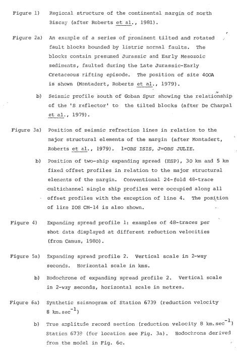
Figure 6a) Synthetic seismogram of Station 6739 (reduction velocity -1
8 km.sec )
- 1 , b) True amplitude record section (reduction velocity 8 km.sec ) of
Station 5739 (for location see Fig. 3a) . Hodochrons derived
from the model in Fig. 5c.
[image:24.598.81.552.91.794.2]-Figure 6c) Ray trace model of the structure along reversed refraction
line 6737-6739.
Figure 7) Ray trace model of refraction profile 1 (oceanic crust)
- 1
obtained using OBS and PUBS. Velocities are in km.sec
Horizontal scale in km. For location see Fig. 3a.
Figure 8) Ray trace model of refraction profile 2 (thinned continental
crust) obtained using PUBS and OBS. Velocities are in
, - 1
km.sec
Figure 9)
Figure 10)
Figure 11)
Figure 12)
Figure 13)
Ray trace model of reversed segment of line 3 from PUBS-4
to the south situated on oceanic crust. Velocities are - 1
in km.sec . Horizontal scale in km. For location see
Fig. 3a.
Ray trace model of reversed segment of line-3 from PUBS-2
to the south on thinned continental crust immediately
north of the continent-ocean transition (cf Fig. 9) . - 1
Velocities are in km.sec
For location see Fig. 3a.
Horizontal scale in km.
Ray trace model of reversed segment of line-3 from OBS
JULIE to the southward. Note the progressive deepening
of the Moho toward the continent and thickening of the - 1
crystalline crust (VP = 6.2 km.sec ). - 1
km.sec
Fig. 3a.
Horizontal scale in km.
Velocities in
For location see
Ray trace model of unreversed line-4 shot on the shelf. - 1
Velocities in km.sec
location see Fig. 3a.
Horizontal scale in km. For
Summary true-scale section of refraction results along
line-3. No vertical exaggeration. Velocities in km.sec
Interfaces have been interpolated between OBS JULIE and
the shelf. Uncertainties are shown by dashed lines. The
continent-ocean transition lies between PUBS-4 and PUBS-2.
For location of section see Fig. 3a.
- 1
Figure 14a) Calculated (+) and observed (continuous line) free-air
gravity profile along line-3. Interfaces have been taken
from the summary section in Figure 13, and densities from
-various publications {see text) . The density model
extended far beyond the limits of the figure and was
constrained by the whole section in Figure 13. The
density contrasts in the upper mantle persisted to 40 km
depth.
Figure 14b) Calculated and observed free-air gravity profile along
line-3. A density contrast in the crystalline crust at about
the level of the 'S reflector' and a lateral variation in
nantle density have been used to produce the agreement
between calculated and observed anomaly. Otherwise the
nodel is as in Figure 13a. Note the thinning of the
lower crust toward the continent-ocean transition. The
gravity residuals can probably be explained by a lack of
two-dinensicnality in the real world. Note the different
gravity scale with respect to Fig. 14a.
Figure 15) Ssjmmary section across the continental margin of North
Biscay incorporating the results of the seismic refraction
profile along line-3, migrated 24-fold 48-trace multichannel
seismic profiles IPF-3 and lOS CM-14, and the gravity
interoretation. For discussion see text.
-23-GEOLOGY OF THE
WESTERN APPROACHES
GGF GREAT GLEN FAULT I F L E A N N A N FAULT SYSTEM FCL FAIRHEAD CLEW BAY LINE SUF SOUTHERN UPLANDS FAULT
THRUSTS FAULT
S.A.S SOUTH A R M O R I C A N SHEAR Z O N E STF STICKLEPATH FAULT
LIMIT OF M E S O Z O I C A N D TERTIARY SEDIMENTARY B A S I N S G - OFFSHORE HERCYNIAN GRANITES
I
!oi a
^ ^ , , S C , D E S
\ w
CELTICSEA BASIN PORCUPINE
SEAB/GHT /'
basin
riT-NTRUSIVE BODY EXTRUSIVE BODY FAULTS
'"Acrrae ZONE
f . v
GOBAN
FAULT DSDP S I T E S
0 'kilometres
inr
3 E
S I T E 4 0 0 A
V
'' wjr
Seismic S ' u d y - B i s c a y C o n t i n e n t a l - o c e a n boundary
X
' Sebmic reffactk«
• P r i n c i p l e f a u f t s
: Contlnenlzf-ocean boiMfary e Ob*.
O Pub# 13 _i
lOSCM
/
iC^
\
S e i s m i c r e f r a c t i o n
T T T T P r i . T C i p f e * * X t »
~ = = C o n t i n e n t a f - o c e a n b c w n d a f y '"'"iimiiiumUJIlIi
13° I
12' _ i
10°
IVIISE A L'HORIZOMTALE DE REFRACTIONS
3.9
4.5
4.7
4.9
5.8
6.0
lesses Appliquees ( K m / s )
3.5
37
6.2
9
~~njr.;« •iV, , 11 •itiy
"ir 'i-' "n:!!, ,•
hT'i" "''Ixii;''!'!!
'|v
p 'inn
mm?— 1 C-t - T
"Tin (II III IIitj
I (IMllHilil IIT l^il
''I 'lllll iliiii llliiri'vill! I'll"'""'""'"'"'
'umiiM :iM" Hl'l iri'Mi'i "
'iim 11 im;:::
iii'ili
r:
iiinnii'iiiiiiiii'iihi 111 Ml nii
:ii "Fi 'III •ir;i;
I m'TMIlg::,.,,, n,,' I ,1
• : I'llli
K'!!iW'i!'ii!!iW '''''I'rciii:!!?"!:;:"!";:;/'':'!
Ii'ii'i||||jjlli||ii|||iil;i||jiiiil"|ii|i| tj|i'iii)!!;|jiii;i: ':i:ii|'j;!;Ti;'"'"'''
niilillHiW! mr,;iyr,,''rir-iT.;i :j;|,,;|i||
• • - - W a ' i W w w m i w n p i v m i M
ii'tl n:'!;''ii"iii'i!;r;;i!':iT|rii!'
'i M 1 " 'I I I 'II , i|
II •"•lini:
1 I trill it'/'i iirailiiiiiiiiilflW
,7 I ' Mill ii|i mil
6.'!,'!!::"!!!!'• iSi'i'ill i^S&ii) nil,Hi)"""'
-S.'xsH uTiti 1*^4 ^CSSinjisiiinmimm'-iiiiii) '
ir'i iv-""i;;"'i(i)|rj"'!i)f t' >i
PI . 'f'|, I I , nil! Ilk ' "hj, , ' n' 'i'*' ''ll, ' „w',' ,/ y-""!!
;SSi.!;SyCvi^
• " ' ' *' - I f S x ; : ; - :
i-r;;;-:—r-r-f::" mnrl-nnrmljpnmniyiqt -h:!r'i|ii^'ii:r'mi;mu:Y''t!m ••'-iwrini;;;;, - :r -"w-iTz'n'r? ri:,i:'''i;:rr:r':n:ri''<T:?'r4
"i„i!!n'ti/ii'ni
^-fl
KlMlip, miliilW,
"i,-'iW'-"'ir''iP'1 '1 ; '"^'1 "1 r,' r"- « I ' ••
D I S T A N C E KM
13 12 11 10
GDP
10 11 12 13 14
4
il^.y • '
\', f,",} -,/.' '; J /';. ..f---;^-!',
X>// y //%
^ i ' i l
s^V ' % % y *
j..r
i - 6
7
8
. 9 . 1 0 11
I. 12
12 . U
. IE
T I M E
LIGNE2
I TETPS m SEC I 6.0 .
ns.o
1 5 . 0 .
1G.0 .
I ' I I I • I 1 ] « I « 1 • I—• 1 ' I ' I ' I I ' I ' T"
0 2 0 0 0 4000 6000 BOOO 10000^2000140001GOOMB00020000220002<000260002800030000
KFicimg rmrAMmer oc nrc r fEn&ACTimG K nrc p
A.
T - # (Sees)
B.
T - # ISecs)
DEPTH IKms)
0
2
4
6
8 10 12 14 16 18 20 22 24 2 6 DISTANCE {Kmsl8 10 12 14 16 18 2 0 22 24 26 28
DISTANCE IKmsl NW
E 10
9
T
-8 (Sees)' 84
•K % «
K-g_i 1 L 1 1 1 1 1 1 1 1 1 J L 1 J : ! 1 ! L_J—1 i 1 I I I I I 1
0 6 12 18 2 4 3 0 3 5 4 2 4 8
DISTANCE (Kms)
DEPTH
4 / 4 4
L
(Sees! W
1 0
9 8
-I - * -I ' ( —'• -* • ' » ..1 1 I ' , I ^ » I > I » I 1 t > I t t
10 15 20
DISTANCE IKmsl
25 30 -I—I—I I I I I
DEPTH IKmsl
35
2.35 3.43 4.52
N
T-l ecsl
111
10
9 -
8-JS » I
10 15 20 25
DISTANCE IKmsl
30
DEPTH Kms!
35 40
4 . 4 4
lOn
9"
T -
X 1
8 8_ (Sees)
7
--X X
I I I I I 1 I I I I I I ' I ' ' 1 I I I : I 1 — I — I — 1 — I — I — I — I — I — I
10 15 20 25 3 0
DISTANCE (Kms)
10 15 2 0
DEPTH (Kmd 10
ISecsl
N
11
1 0
9
8
-7
6
JL—I—1—I—I—1—1—I—I I I I 1 I I ' ' ' ' 1 • • ' • ' I I I I I I I I 1 ' t i t I I t t t I t
10 15 20 25 30 35
DISTANCE IKms!
10 15 20 25 30 35
40 45 50 55 60 65 70
DEPTH
IKmsl
8 . 0 5
w
T - #
ISecs)
8-j 7 6 5 4 4 3
t » t t t t t « I t t I t I t I I I t I 1 I » t I t t I t t » t I t > t I « t t t t I < I « t I I J
DEPTH
IKmsl
20 4 0 60 80 100 120 140 160 180 200
DISTANCE IKmsl
120
8 . 0 5
5 0 J
OBS J U L I E
V OBS ISIS • PUBS 2 2
OBS JULIE
V OBS ISIS V PUBS 2 V PUBS 5 V
PUBS 3
V PUBS 4 V
c o n t .
0
L. _L 3 0
0 o o 1 U-J
G G M / S O M
1—1 1
< < < <
II II 11 II A W I S ) 6 ) A 6 )
!
• 0 D t > T 3 11 I I II
) t o N ) N )
% A I n
C O 0 3 O
MGAL
W 0)
o 1
-G -G M / S O M E
C/5
o
z
m
w
7 7 7 ? to fo ro fo (OA In k) m 03 O in
4a.
NE
OBS JULIE
, •• ~ 7 , • ~
OBS ISIS V
PUBS 2 PUBS 5
V V
%0
ml
_ _ _ - - ^
CONTINENTAL
OBS ISIS PUBS 2 PUBS 5 PUBS 3
V V V
SW
PUBS 4
V
0
L