EULOGIES OF LAW & SOIL
ANNIE SIMPSON
Eulogies of Law & Soil
By Annie Simpson
This document accompanies the thesis work in exhibition at the John and June Allcott Gallery from April 15 – 19
Senior Honors Thesis Statement Department of Art
University of North Carolina at Chapel Hill
April 4, 2019
Approved:
______________________________________
elin o’Hara slavick, Thesis Advisor
______________________________________
Hồng-An Trương, Committee Member
______________________________________
Gesche Wuerfel, Committee Member
I would like to acknowledge the John Hope Franklin Student Documentary Award at the Center for Documentary Studies at Duke University, The Gump Family Undergraduate Research Award, and the James Boyd Gadson Fund for Summer Fellowships in Studio Art at the University of North Carolina at Chapel Hill. It was only through their support that this project became possible.
Special thanks are due …
to my committee: elin slavick, Gesche Wuerfel, and Hong-An Truong,
your continued support has been worth more to me than I can ever begin to put into words.
and to my parents, Brian Simpson and Eileen Reap Simpson,
for making me go outside every day before school as a kid to muck horse stalls.
Territorial Acknowledgement
The land upon which Northampton County, North Carolina now sits is the traditional territory of the Meherrin people. It is easy to forget that slavery was not the South’s original sin.
To learn more about which Indigenous peoples' land
you are currently on, please visit: www.native-land.ca.
“Wherever We walk We will make
Wherever We protest We will go planting”
Muriel Rukeyser
Preface
Two or three things I know for sure, and one of them is that just as I reside within this heavy history of the American South, it also resides within me; that whole thing about gazing into the abyss and it gazing back. Another is that kudzu here is a metaphor for white-supremacy, and that shit is everywhere.
I grew up unsupervised in the North Carolina landscape. At ten I was given a pony and a walkie-talkie and told not to do anything too stupid. I rode like a bat out of hell, through groves of pecan trees and across the dips and rises of hay fields. It was in those years up on the horses that I fell in love with sunlight filtering through the waxy leaves of magnolias and the look of tall, wet grass wrapping up and around my feet. (This was all before I learned to ask, “who planted all those fabled magnolias?”) Everything I’ve ever done, or has been done upon me, and everything I have ever loved has led me here, constantly, unrelentingly back to these landscapes.
With or without my consent, I am compulsively driven to map how and why this place has been my ghost and shaped my consciousness for as long as I can remember.
If it is my past and these resplendent, wicked landscapes that bind me to this place, how do I reconcile that with how we in the South so often recall and represent our past inaccurately?
Remembering is always entangled with forgetting, and our memories are “always transitory, notoriously unreliable, and haunted by forgetting,” but there is something sinister in the way we white Southerners fail to recollect what actually happened here, who planted these fabled
magnolias, and whose blood this land has absorbed.
1It’s a wonder we actually do feel ties to this place, or at least feel so little shame to be tied here.
1 Andreas Huyssen, Present Pasts: Urban Palimpsests and the Politics of Memory, (Stanford: Stanford University Press, 2003), 28.
Introduction
Northampton County sits nestled up in the elbow formed by the Virginia / North Carolina border and the Roanoke River. In the last decade, the ten towns in North Carolina with the largest percentage population decline were all in 3 counties – Bertie, Northampton, and Washington. Five of these ten towns were in Northampton.
Projections for … Northampton … County indicate that further population decline is imminent. According to the Census’ data on components of change from 2010 to 2016, each of these counties demonstrated negative natural growth or natural decrease – whereby deaths outnumber births – and net out-migration from the county. This pattern has occurred each year since the last decennial census.
2
Northampton County is also a county that the federal government describes as demonstrating persistent poverty; this means that over 20% of the population have lived in poverty every day of every year for the past 30 years.
3However, one could say the same of the past 150 years. The history of this persistent poverty traces directly back to slavery.
As an artist, I grapple with making landscape photographs of this county. Landscape images, no matter how straight forward, are subjective & bound up in cultural memory which shapes narratives that obfuscate the racist violence done upon people within the landscape. This project seeks to show the political and duplicitous landscapes of Northampton County through the context of environmental racism. I will narrate how topography lends itself to formulating one’s conception of self, how this historical micro-chasm of environmental terror fits into the record of racism that is integral to American history, and how the Southern landscape as a
cultural construction is, at its heart, deceitful and memorialized through ahistorical remembering.
2Jessica Stanford, “Examining Decline in North Carolina’s Municipalities,” Carolina Demography, Published July 5, 2017, https://demography.cpc.unc.edu/2017/07/05/examining-decline-in-north-carolinas-municipalities/.
3 U.S. Department of Agriculture, Economic Research Service, Persistent Poverty 2013, 8, https://www.rd.usda.gov/files/RD- PersistentPovertyCountiesList2016.pdf.
I. Specificity of Place
In an interview with the Paris Review, William Faulkner said, “I discovered that my own little postage stamp of native soil was worth writing about and that I would never live long enough to exhaust it”.
4Faulkner was passive at best in regards to the Civil Rights Movement and integration, but he does get this right: through what artists would call “close-looking” at a piece of land seeming infinitely small or insignificant, and pursuing what binds one to it all the way to its lair, one can find enough artistic and intellectual fodder to last a life time. (Or enough to make you drink until you get thrown from your horse and nearly die, depending on how you look at it.)
North Carolina is my home; its beauty and wickedness both repulse me and keep me here in some sort of horrible but inspired stasis. When making work about this place I have no room for sympathetic honeysuckle-sickly-sweet romanticism of the land. It is easy to lose the South behind the thick humidity that blurs the horizon line in late September, to forget what this land has seen and absorbed. It witnessed and fostered slavery, lynching, burning crosses and white cloaks, negative peace in the name of order, redlining, sharecropping, and what the body cams do not show us. When we forget, this land remembers.
Northampton County slopes down towards the coast to the East. Most of the county lies in North Carolina’s coastal region, where the soil is sandy and drains poorly. Since its
construction, I-95 has directed traffic away from the once bustling state highways that bisect the county.
5It is easy to see the remaining traces of slavery here; of the 433 farms in the county, only 51 have Black principle operators though 60% of the population in the county is Black.
6The primary crop on these farms is cotton.
4 William Faulkner, interviewed by Jean Stein. “The Art of Fiction No.12,” The Paris Review, Issue 12, 1956.
5 Rebecca Spanbauer, “Northampton County Comprehensive Historic Architecture Survey, Phase II: Final Report,” 129, April 28, 2010.
6 U.S. Department of Agriculture, 2012 Census of Agriculture, Northampton County, North Carolina, 2,
https://www.nass.usda.gov/Publications/AgCensus/2012/Online_Resources/County_Profiles/North_Carolina/cp37131.pdf.
Northampton County also relies heavily on pine logging to feed the Enviva wood pellet plant on the Western side of the county. Belinda Joyner, a substitute teacher and an organizer against the Atlantic Coast Pipeline, has become a guide and close friend of mine over the past year. She calls the county North Carolina’s dumping ground and lives a few miles down the road from the plant. At night, sitting in her living room, you can hear the pine trees being rolled in the great machinery to strip them of their bark. When Enviva came to the county, they were given a tax incentive: a 50% reduction for the first five years they were open. The Board of
Commissioners thought that this incentive would ultimately benefit the county because of the jobs it would give to residents. However, Enviva is an open plant – meaning it has no contract to hire county residents.
7Its proximity to I-95 and the Virginia border has greatly hurt the county, given that Enviva brought in its own people to run the plant. The plant emits 337 tons of Volatile Organic Compounds each year and is the largest wood pellet mill in the country that does not utilize VOC control technology.
8In the early 1990s a company named ThermalKEM attempted to place a toxic waste incinerator in the county. Grassroots activism brought together residents to lobby their Board of Commissioners to deny ThermalKEM the land use permit. In photos of a related demonstration, the racial divide between those supporting the incinerator and those opposing it became rather clear.
9At this same demonstration on 9/23/1991, seventeen people protesting the incinerator were arrested.
10ThermalKEM was 100% owned by the German firm NuKEM GmbH, which was 35% owned by Degussa AG. Degussa AG supplied chemicals to Nazi Germany for use in
7 Belinda Joyner, interview with author. September, 2018.
8 Patrick Anderson and Keri Powell, “Dirty Deception: How the Wood Biomass Industry Skirts the Clean Air Act,”
Environmental Integrity Project, April 26, 2018, 13, https://www.eenews.net/assets/2018/04/26/document_daily_02.pdf.
9 Northhampton County: Woodland: Protest against Thermal Kem incinerator, 14 September 1991, P0090 Black and White Film Box 03, Color Film Box 02, Print Box 02, Flat Box 01, Jerome Friar Photographic Collection and Related Materials, 1978-2010, North Carolina Collection Photographic Archives, The Wilson Library, University of North Carolina at Chapel Hill.
10 Dennis Patterson, “Incinerator opponents create havoc,” The Daily Independent, September 23, 1991.
the death chambers of concentration camps. Degussa AG also sold chemicals to North Korea and India to develop nuclear weapons.
11I witnessed this same racial divide this past summer as residents geared up to oppose a new coal ash pit proposed by Raleigh based company, Vista Green, that was applying for a land- use permit. Jackson, the county seat, had a banner stretching across a stalled-out auto shop reading “NON-HAZARDOUS COAL ASH = NORTHAMPTON COUNTY JOBS.” In comparison, Seaboard a few miles to the North had a sign in almost every front yard opposing the coal ash. Jackson is 54% white, and Seaboard is 22% white.
12Luckily, the Board of Commissioners denied the land use permit for Vista Green. Mike, who lives only a mile or so from what was the proposed coal ash site, was glad the county voted against it, but is still worried about what they will put there instead. The lot next to him is densely wooded, but in the next few months it is supposed to all be cut down for timber. Mike says he would have bought the land in order to save it, but he doesn’t have the money; he spent his army pension on his house. He bought the house for $30,000 over a year ago, which is already a good deal for the acre or so of land. He got an additional discount off the purchase price because he promised the sellers he would preserve a unique piece of history that sits at the front of the property.
Mike’s land is home to a peculiar one room structure called “The Occoneechee Trapper’s Lodge” built by a man named QJ Stephenson beginning in 1958. When Mike bought the place, he barely knew the building was there because it was so densely covered with vegetation. He has since cleared most of the foliage off of the Lodge, and in doing so discovered an archipelago of
11 “North Carolina: Part 3,” Waste Not: A Publication of Work on Waste USA, Issue #166, September 26, 1991.
12 “Jackson, North Carolina Population 2018,” World Population Review, Accessed November 16, 2018,
http://worldpopulationreview.com/us-cities/jackson-nc-population/; “Seaboard, North Carolina Population 2018,” World Population Review, Accessed November 16, 2018, http://worldpopulationreview.com/us-cities/seaboad-nc-population/.
found object sculptures dotting the property. QJ Stephenson was a self-taught artist who built fantastical creatures, totem poles, and reliefs out of bottles, quartz, concrete, petrified wood, amber, whale bones, and items pulled from the swamps near his house. It turns out that the Smithsonian Museum owns a few pieces by Stephenson (Figure 1) that were taken from this property after Stephenson’s death, and the MoMA showed some of his work in the late 1980s.
13Mike is glad he owns the land, especially because he grew up on an Indian reservation up North and Stephenson was Occoneechee. Stephenson was an also an avid environmentalist who worked during his young adult years in Teddy Roosevelt’s Civilian Conservation Corps out West protecting redwood trees. Most days, Mike sits out in front of the Lodge in a folding director’s chair, waiting for visitors to slow down and stay for a while. From his seat, one can see where teams are clearing a path through groves of trees and fields of cotton to make way for the Atlantic Coast Pipeline. Mike and I tensely laughed when we talked about how ironic it is that this place lovingly built by a man who cared so much about the land “along the creeks and in the swamps” up here would be shockingly close to the pipeline. We grew silent after talking about the dangers of it – how you only know there’s a leak in the pipeline when you step outside to light a cigarette and accidentally blow your whole neighborhood up.
The Atlantic Coast Pipeline is a joint venture between Duke Energy and Dominion Energy. Of the eight counties the pipeline will bisect, seven have poverty rates higher than the state median, and seven have a percentage population of Black residents that exceeds that of the state.
14In Northampton County, the poverty rate exceeds the state’s by 13 percentage points.
13 “Q.J. Stephenson,” Smithsonian American Art Museum, https://americanart.si.edu/artist/q-j-stephenson-4627; “Here and There:
Travels, Part I: Outside Insigh,t” The Museum of Modern Art, https://www.moma.org/calendar/exhibitions/4506?locale=fr.
14 Sue Sturgis, “INSTITUTE INDEX: The mounting injustice of the proposed Atlantic Coast Pipeline,” Facing South, November 17, 2017.
Northampton County will also be home to a compressor station for the pipeline. It will release 240 pounds of formaldehyde into the air every 24 hours.
15Formaldehyde, alongside ammonia, is just one of the fifteen TRI chemicals (Toxic Release Inventory chemicals as designated by the Environmental Protection Agency) contained in the 199,639 pounds of chemicals released each year into the air or soil by the Georgia Pacific resin plant in Conway, located near the center of Northampton County.
16When I went to
photograph the plant, I was stopped by Ron Walls, the plant manager. The first thing he said to me was, “who do you work for?” I explained I was a student working on a project about the county. He told me that photographs were not allowed inside the property and that they would reflect poorly on the plant. I was not standing on the property. Directly on the other side of the fence was the carcass of a dead deer that died sometime after getting trapped inside the plant’s security fence. I wish that I had told Walls that I had a right to be there, given that I was on a public road. But, I didn’t. When he told me that I needed to leave, I nodded and packed up my cameras, frustrated that I just drove 40 minutes out here from my hotel a county over to catch the sun as it set, illuminating the western-facing plant.
Georgia Pacific is owned by Koch Industries. Both of the Koch brothers have lobbied the EPA to avoid putting formaldehyde on their known carcinogens list (right now it is only a
“probable” carcinogen).
17Several studies show that people who are regularly exposed to
15 “Northampton County Compressor Station Air Quality Modeling Report,” Dominion Energy Transmission, Inc. and Atlantic Coast Pipeline, LLC, January 2018, 25,
https://files.nc.gov/ncdeq/Energy%20Mineral%20and%20Land%20Resources/DEMLR/Atlantic-Coast- Pipeline/Northampton%20Air%20Quality%20Modeling%20Report%201-2018.pdf.
16 U.S. Environmental Protection Agency, Georgia-Pacific Chemicals LLC Facility Report, 2017,
https://iaspub.epa.gov/triexplorer/release_fac_profile?TRI=27820GRGPCAMPAC&TRILIB=TRIQ1&FLD=&FLD=RELLBY&
FLD=TSFDSP&OFFDISPD=&OTHDISPD=&ONDISPD=&OTHOFFD=&YEAR=2013.
17 “The Koch Brothers’ 10-Year Campaign to Delay Action on Formaldehyde, which is known to Cause Cancer in Humans,”
Prevent Harm, 2014, https://preventharm.org/the-koch-brothers-10-year-campaign-to-delay-action-on-formaldehyde-which-is- known-to-cause-cancer-in-humans/.
elevated levels of formaldehyde are more likely to develop leukemia and nasopharyngeal cancers.
18Lung and bronchial cancer rates are 15% higher here than the rest of the state.
19I spent the drive home thinking about Joel Sternfeld’s State Highway 74, 7.3 miles south of the former Hub Cafe, outside Crescent, Oklahoma (Figure 2). It depicts a road cutting across
the frame, interrupting a green and yellow field. This is the road where Karen Silkwood was found dead in her car. She was on her way to meet with a reporter about evidence against her employer, the Cimarron River Plutonium Plant. The manila folder containing that evidence was gone when her car was discovered, and independent investigators concluded that her car had been run off the road. I wonder what Walls meant when he aggressively asked me who I worked for. What does he know that we do not? (Digression: Sternfeld’s prolific project Oxbow Archive was located in Northampton, MA.)
Yet, formaldehyde is not the only danger of the pipeline. In early August 2018, the Federal Energy Regulatory Commission (FERC) halted work on all 600 miles of the Atlantic Coast Pipeline, only four days after the U.S. Court of Appeals for the Fourth Circuit overturned two federal permits for the pipeline: one failed to outline the pipeline’s destruction of habitats for species listed as threatened or endangered under the Endangered Species Act and the second would have allowed the pipeline to cross the Blue Ridge Parkway. However, the FERC lifted this stop-work order on September 17
th, 2018.
On August 18
th, 2018, the Southern Environmental Law Center issued a 45-page
document to North Carolina’s Department of Environmental Quality, outlining how the Atlantic Coast Pipeline does not meet the threshold of safety required by section 401 of the Clean Water
18 Luoping Zhang, “Formaldehyde exposure and leukemia: A new meta-analysis and potential mechanisms,” Mutation Research 681, no. 3 (June 2009): 150-186, Science Direct.
19 North Carolina Department of Health and Human Services, “2011-2015 NC Cancer Incidence Rates per 100,000 Population Age-Adjusted to the 2000 US Population,” https://schs.dph.ncdhhs.gov/data/databook/.
Act for the Division of Water Resources to issue a permit for pipeline construction. Their argument, co-signed by The Sierra Club, the NC Conservation Network, Clean Water for NC, the Natural Resources Defense Council, Sound Rivers, Concerned Citizens of Tillery, and Winyah Rivers, rests on the proof that the pipeline would cause disproportionate harm to underrepresented communities in the state and long-term damage to the environment in Eastern NC, thus the application materials provided by the ACP do not demonstrate compliance with state regulations.
20Specifically, the damage to the environment results from the ACP’s disruption of rivers, streams, seasonal creeks, and swamps:
Construction and operation of the ACP will cause extensive and long-lasting impacts to North Carolina’s waterbodies and wetlands. During construction, a total loss of stream, wetland, and riparian habitat will occur within a construction right-of-way that can be up to 75 feet wide… For virtually all 468 acres of impacted wetlands, the blasting and the digging of trenches will occur directly in saturated waters, causing excessive
sedimentation and destroying fragile layers of hydric soil that … perform unique wetland functions.
21The memo also details how the pipeline will threaten low-income communities, racial and ethnic minorities, and state-recognized Indian tribes. In Northampton County in particular, the adverse health effects of the pipeline will be amplified by the Compressor Station located in Pleasant Hill, north of Garysburg.
[There] will be disproportionate impacts from Compressor Station Three in Northampton County to African American communities. The Northampton County compressor station would be placed in census block group 6 (of census tract 9203), which is approximately 79.2 percent African American—also far higher than the population in the state, which is about 22 percent. Proximity to compressor stations can cause serious health problems, including respiratory ailments and cardiovascular disease from ozone exposure, as well as gastrointestinal, neurological, and psychological effects from toxic volatile organic
20 Geoffrey Gisler, “Comments on Section 401 Certification Application for Construction of the Atlantic Coast Pipeline,”
(Chapel Hill: Southern Environmental Law Center, 2017),
https://www.southernenvironment.org/uploads/words_docs/Comments_on_NC_401_Certification_Application_for_ACP.pdf.
21 Gisler, 7.
compounds, particulate matter, and other dangerous substances associated with natural gas infrastructure.
22In the Environmental Impact Statement provided by the ACP, Garysburg, located near the western edge of the county, is listed a “high consequence area”.
23This means that this is an area within which the extent of damage to property or the chances of serious injury or death are significant in case of a rupture or significant leak, generally taken as 20 or more occupied buildings within the potential impact radius of the pipeline, or where there are particularly vulnerable populations, such as day care centers, retirement homes, or handicapped persons.
24The potential impact radius (incineration zone), is the distance at which there is a reasonable risk of incineration, injury or even death. For a 36 inch pipeline operating at 1440 pounds per square inch (psi), this zone extends at least 943 feet from the pipeline.
25The neighborhood in Garysburg most at risk is entirely Black and sits on a plot of land overlooking a cotton field that only ends when it hits the main logging road used to take pine trees to the Enviva plant. This neighborhood contains a historic cemetery from which you can see the cleared path for the pipeline through the thin tree line. All the streets here are named after presidents.
In 1994, Reverend Benjamin Chavis, then president of the NAACP, summed up this correlation between race and toxic pollution by stating that,
“Environmental racism is racial discrimination in environmental policy-making and enforcement of regulations and laws, the deliberate targeting of communities of color for toxic waste facilities, the official sanctioning of the presence of life threatening poisons and pollutants for communities of color, and the history of excluding people of color from leadership of the environmental movement.”
2622 Gisler, 5.
23 Oshin Paranjape, Hope Taylor and Ericka Faircloth, “High Consequence Areas, Blast Zones and Public Safety along the Atlantic Coast Pipeline,” Clean Water for North Carolina, September, 2017, 1, https://cwfnc.org/documents/Updated-Report- High-Consequence-Areas-Blast-Zones-Public-Safety-along-the-ACP-10-2-2017.pdf.
24 Ibid.
25 Paranjape, 2.
26 Benjamin Chavis, Jr, 1994.
Today, the county remains heavily rural and depends on an economy fueled primarily by peanut, soybean, and cotton production.
27Of these farms, 88.2% have white principle operators, perpetuating systems of modern sharecropping that trace their roots to plantation slavery.
28One of the most prominent plantations in the area is Mowfield Plantation, erected in 1804 just outside of Jackson, the county seat.
29Here lived the greatest racehorse of the day, Sir Archie, during the 1820s; Sir Archie is the foundation sire of all American Thoroughbreds. Of all of the twelve horses to ever win the Triple Crown (meaning the horse would have to win the Belmont Stakes, Kentucky Derby, and Preakness Stakes in the same season), eleven directly trace their lineage back to Sir Archie. My most beloved horse, Calisto, was an American Thoroughbred, meaning all signs point to him descending from Sir Archie and Mowfield. The plantation house was once painted by Edward Hopper for the cover of a later owner’s book about Sir Archie (Figure 3).
Unfortunately, this owner did not appreciate Hopper’s painting of Mowfield, saying it looked nothing like his style. When Hopper went to deliver the final painting, the owner had taken down all of his paintings off of her walls and replaced them with other paintings of Sir Archie.
30Polenta Plantation was another prominent plantation in the county, though it no longer stands. It sat in what is now Rich Square and belonged to the Devereux family, among the largest landholders in North Carolina during the antebellum period, who owned eight plantations across Halifax, Bertie, and Northampton counties.
31On December 10, 1857 at Polenta Plantation, Thomas P. Devereux sold 92 enslaved persons for the lump sum of $51,575.
32Adjusting for
27 Spanbauer, 115.
28 U.S. Department of Agriculture, 2012 Census of Agriculture, Northampton County, North Carolina, 2,
https://www.nass.usda.gov/Publications/AgCensus/2012/Online_Resources/County_Profiles/North_Carolina/cp37131.pdf.
29 Spanbauer, 28.
30 Gail Levin, Edward Hopper: An Intimate Biography, (Berkeley: University of California Press, 1995), 353.
31 Margaret Devereux, Plantation Sketches, (Cambridge: The Riverside Press, 1906), 2.
32 Northampton County, North Carolina Register of Deeds, Book 36, pg. 582. http://northamptonrod.org/BookAndPage.asp.
inflation, that would be $1,571,390.83 today. Devereux’s granddaughter, Margaret Devereaux, grew up on these plantations. She went on to write Plantation Sketches near the very end of her life, a book about her time there. In her own words, she wrote this book because,
As the "New South," with all its changes and improvements, rises above the horizon, those whose hearts still cling to the "Old South" look sadly backward and sigh to see it fade away into dimness, to be soon lost to sight and to live only in the memory of the few. Hoping to rescue from oblivion a few of the habits, thoughts, and feelings of the people who made our South what it was, I have drawn from memory a few pen sketches of plantation life, based upon actual events, in which are recorded some of the good and even noble traits of character which were brought forth under the yoke of slavery.
33I would contest that the so called “New South” never rose above that horizon. The landscape here is as oppressive as it ever was. One need not look backward to see Polenta Plantation. It is superfund and coal ash, pipeline and pine tree.
33 Devereux, ix.
II. Memento Mori
Desire has no history - it is experienced in immediacy. For a photograph to resist simply satiating and connecting with foreground desire, to awaken moral feelings or conscience, it must be unambiguously linked to history. It is the temporal specificity of history that, when related to the photograph, can mobilize a moral conscience, according to the theories of Susan Sontag.
34However, the photograph will always be rooted in time-based inconsistency through its
immediacy (holding or experiencing the photograph as an object in the present moment today, of its being-here), and temporal remoteness (awareness of the existence of the image as a document of a previous moment, of its having-been-there).
35It is the photograph’s complex relationship with time and voyeurism that makes it an appropriate medium to respond to the history of Northampton County. In a way, all art is temporal- the rhythm of brush on canvas, the hours spent waiting for clay to cure- but it is only the photograph, in its ability to slice out and freeze a sliver of time, that can testify to the relentless and all-pervading passage of time. All photographs are memento mori.
36Barthes describes the relationship between the photograph and death as a primitive theater, likening it to the motionless and stylized faces of the dead in open-casket funerals.
37All photographs are death-signifiers.
Throughout history, the camera has been used as an instrument to humiliate, in which the dissemination of the photograph completes the ritual of degradation. From lynching post-cards to images on our TVs of those killed abroad by United States’ Armed Forces, the photograph is not a witness, but instead a tool for the image maker to dehumanize and strip its subject of reality,
34 Susan Sontag, On Photography, (New York, Farrar, Straus and Giroux, 1977), 16.
35 Roland Barthes, Camera Lucida: Reflections on Photography, (New York, Hill and Wand, 1988), 79.
36 Sontag, 15.
37 Barthes, 32.
reducing it to a moment on a 2-D plane. In my photographs I grapple with this: how to avoid the creation of a spectacle, how to resist the exhibition of direct representations of suffering and violence. In The Civil Contract of Photography, Ariella Azoulay argues that “[p]hotography is an apparatus of power that cannot be reduced to any of its components: a camera, a photographer a photographed environment, object, person, or spectator.”
38As a result “photography”
encompasses the production, distribution, exchange, and consumption of the photographic image.
The camera (and its twin capabilities – to subjectify and objectify reality) will always serve the functions of capitalist society. Cameras and thus photographs create a spectacle for masses at the same time as they work as objects of surveillance for rulers.
39During the latter half of the 19
thcentury, when the camera and photography became more accessible, the world
experienced rapid change as the result of Industrialization and New Imperialism. It captured flora and fauna, exotic and vernacular, that would suffer greatly at the hands of these two forces. Thus,
“the photographic image became the privileged mode of documentation through which barbarism could be made evident to a previously uninformed citizenry.”
40*
Some of the earliest iconic images of the American South come from Matthew Brady’s photography of the Civil War. Many of these images depict misty battlefields, shrouded in heat or fog, and strewn with the bodies of the dead. The imagery is striking: the resplendent, rolling landscape violated by military trenches and loss of human life, all for the tacit defense of slavery (Figure 4). He also photographed the ruins of destroyed Southern cities; interestingly enough, these images of a burned out Richmond were later used by lost-causers to justify their belief that
38 Ariella Azoulay, The Civil Contract of Photography, (New York, Zone Books, 2008), 85-86.
39 Sontag, 178.
40 Roger I Simon, A Pedagogy of Witnessing: Curatorial Practice & the Pursuit of Social Justice, (New York, SUNY Press, 2014), 20.
* Please note that barbarism here should be read with critical lens.
the South only seceded because of the tyranny of union rule. However, it was the Confederacy that actually burned Richmond (Figure 5). Soldiers set fire to the cotton stores outside of the city during their retreat South to Danville in order to keep the cotton from the hands of the Union army, but the fire spread to the city.
Sally Mann revisits many of these battlefields once photographed by Brady in her series
“Battlefields” (Figures 6 & 7). She is “looking for the answer to [the] very question: does the earth remember? Do these fields upon which unspeakable carnage occurred, where unknowable numbers of bodies are buried, bear witness in some way? And if they do, with what voice do they speak? Is there a numinous presence of death in these now placid battlefields, these places of stilled time?”
41She searches for the spectral traces of what the war left behind. Often shooting at night, her wet-plate images are distorted by dust and cracking collodion. “When I was
shooting with collodion, I wasn’t just snapping a picture. I was fashioning, with fetishistic ceremony, an object whose ragged black edges gave it the appearance of having been torn from time itself. The whole operation had a contemplative, solemn, even memorial feel to it. There was a gravitas to the act, as if it were a form of Holy Communion”.
42The abstraction that resulted from the meditative, funereal process conceptually lends itself to ideas of death within the landscape.
However, this landscape that she photographs is one of unspeakable pain and suffering. I find her work lacking in critical dialogue with how these landscapes have repeatedly inflicted the most violence upon Black people with the explicit intention of upholding white master
narratives. When she refers to Civil War battlefields as “places of stilled time,” she forgets that most of the South exists also in a state of violent homeostasis. Remains of Black Codes, slavery,
41 Sally Mann, Hold Still, (New York, Little, Brown and Company, 2015), 411.
42 Mann, 224.
and lynching are omnipresent in our landscape, not just residue; one must only look to current forms of sharecropping, the militarization of police, the prison-industrial complex, redlining, and environmental racism.
When I first started making photographs with any seriousness, sometime in 2015 or 2016, I found myself unconsciously photographing many of the themes the Mann explores in her own work. I made a lot of photographs of my mother (Figure 8); I made a lot of photographs trying (and failing) to deal with symbology of the South (Figures 9 & 10). At the time, I did not really understand what I was doing. Looking back now, I can see what I was doing and recognize that I was in fact pretty bad at it – I was neither critical nor poetic. During those days, I was obsessed with the stretch of highway between Chapel Hill and Charlotte. I still refuse to take Interstate-85 to travel back and forth, only taking HWY 64 to HWY 49. These backroads are dotted with small farms, rolling hills, and burned-out textile towns like Siler City and Asheboro. Every time I saw something that interested me, I would pull over and start making photographs. My mother would complain that sometimes it took me five or six hours to complete the two-hour drive. I was neurotic, compulsive, oppressively obsessive. I slipped back into that habit during my time in Northampton County. As I would drive along the pipeline, I stopped my car so often to make images that I found it was more effective to just park my car and walk a mile or so and back on foot.
Bill Christenberry, born in rural Hale County Alabama, effectively demonstrates this
compulsion through his own work. Every year from 1961 up to the decade before his death in
2016, he returned to Hale County from Washington, DC to make photographs. The annual
pilgrimage began as trips to gather reference images for his painting and sculpture, but later grew
into a body of work of its own. William Ferris, professor emeritus of history at the University of
North Carolina at Chapel Hill says of Christenberry: “What Faulkner has done in his fiction, [he]
has done in his photography. ... He has such a feel for what Eudora Welty called ‘the sense of place’”.
43Christenberry’s ties with place seem deeply fraught, for as much as he loved it, his images, often of buildings captured head-on, feel removed, objective. With the knowledge of his work amassing and cataloging the horrific ephemera of the Klu Klux Klan, his photos of space across time take on new meaning. How do we conceptualize place and belonging within
histories of terror and suffering? His series on Red Building read like a living eulogy (Figures 11 – 13). When I see them, the feeling of being unable to stay, yet driven to return is palpable.
I grew up amidst the most beautiful landscape I can imagine. I remember being ten years old and riding my pony through our grove of pecan trees. I spent a lot of time alone and outside as a kid, climbing magnolias or sitting in the hayloft of our old barn, whittling sticks into Harry Potter wands. (I have no idea why I was left alone with box cutters, or why no-one ever told me not to do things like that.) To this day, I’m convinced that there is nothing more beautiful than the horse farms I grew up on. However, as I grew into a greater understanding of the context of American landscape – who and what purposes this land has served – I found it difficult to see my home in the ways that I had previously. (We live in a white-supremacist landscape – but more on that later.)
Joel Sternfeld grapples with tragedy, landscape, violence, and place in his series On This Site. The work seems to posit landscape as memorial image, featuring photographs of 50
locations in America where acts of violence had occurred, using the photograph to interrogate the traces that violence leaves behind on the landscape. When contextualizing Mount Rushmore National Monument (Figure 15), Sternfeld writes:
43
William Ferris, The Storied South: Voices of Writers and Artists, (Chapel Hill, University of North Carolina Press, 2013).
In 1868, the Federal Government deeded millions of acres in the Black Hills of South Dakota to the Great Sioux Nation. Nine years later, when gold was discovered in the area, Congress broke the treaty and took the land back. In the 1920s, the State of South
Dakota, eager to attract tourists, commissioned a sculptor to carve colossal monuments into Mount Rushmore. The Sioux still considered the Black Hills to be their sacred land.
In 1980, the Supreme Court awarded the Sioux $17 million plus interest accrued since 1877 as compensation. The award is now valued at nearly $300 million, but the Sioux continue to both refuse the money and seek title to the land.
Part of the success of this work as a series depends on text. The writing that accompanies the image is an imperative, as it directs the reading of the image. The image without the text would not just be an image of Mt. Rushmore, as no image of that place could be read devoid of colonialism and manifest destiny, but it is the specificity and detail in the text which informs viewers of the specificity of violence. Colonialism and its implicit imposition of degradation is universal, but the text brings this fact to the emotional forefront.
LaToya Ruby Frazier deals with environmental racism in her hometown of Braddock, PA through her series “The Notion of Family”. The images that she makes use personal and familiar history to counter dominant narratives of the region that center Andrew Carnegie and the “boon”
brought by industrialization. In the body of work, she includes photographs of interiors, intimate portraits, and wide angle “landscapes” of toxic steel mills (Figure 15) and shuttered buildings to narrate the racial implications of economic and community decline. Her images make the personal political.
I only began to read the photograph as metaphor when I was introduced to Alec Soth’s
photographs several years ago. Understanding that a photograph of a mattress floating in water is
not about a mattress floating in water (or how a photograph of a book on a windowsill is not
about a book on a windowsill) (Figures 16 & 17) was one of the more formative experiences I’ve
had in the Art Department here. The images speak to the longing and reverie found off of
America’s third coast; they are as descriptive as they are lonely. Soth’s practice has also informed much of my own; "I fell in love with the process of taking pictures, with wandering around finding things. To me it feels like a kind of performance. The picture is a document of that performance".
44The photograph can only be made by being there. One must perform within the landscape to make an image of it, and thus this performance can never be removed entirely from the image itself. Following this line of thinking, the photographer as a performer cannot be stripped away either. How do I as a white artist fit into this violent landscape from which I benefit? This
question is especially important given that almost all of the photographers I have mentioned thus far have been white and that the most “prolific” photographers working across time with the South as a subject have been white. In my photographs I attempt to avoid the direct creation of a spectacle and challenge master narratives about the Southern landscape while naming
perpetrators and the systems that perpetuate cycles of harm and violence.
44
Alec Soth, interviewed by Aaron Schuman. “The Mississippi: an Interview with Alec Soth,” SeeSaw Magazine, 2004.
III. Duplicitous Landscape
"After the most recent U.S. election, I stopped traveling and stayed home in Minnesota. I also stopped photographing strangers. I preferred to drive into farm country without talking about politics or ideology. But I was also aware that my ability to do this sort of apolitical wandering was the result of the enormous freedom and privilege with which I was born. Every landscape, no matter how subdued, can be seen as a political landscape."
Alec Soth
In his 1988 text “Constitutional Faith,” leading American legal scholar Stanford Levinson argues that "the brooding omnipresence of American history - race, and more precisely, slavery"
can never be removed from the American Constitution.
45The same can be said for the American landscape. Abolitionist sentiment arose not solely through clarity from conscience, but in part from topographical circumstance. The Northern landscape was not suited for plantation
agriculture and thus failed to develop large-scale agrarian slavery. As a result, the North became a society with enslaved people, as opposed to a “slave society” (which instead developed in the South through plantation life)
46. So only without the economic imperative to maintain the brutal and senseless system of chattel slavery, could they call for its abolition. I do not contend this to absolve anyone from the enslavement of other human beings, but to instead highlight how topography informs what sort of violence we allow ourselves to be complicit in. “[V]iolence was not only common in slave societies, it was also systematic and relentless; the planters’
hegemony required that slaves stand in awe of their owners”.
47The images in the project respond not only the record of environmental racism that physically shapes the landscape in Northampton County, but also to the most widely-distributed publication about the landscape here, Margaret Devereux’s Plantation Sketches. The book
45 Stanford Levinson, Constitutional Faith, (Princeton, Princeton University Press, 1988) 186.
46 Ira Berlin, Many Thousands Gone: The First Two Centuries of Slavery in North America, (Cambridge, Harvard University Press, 1998), 96.
47 Berlin, 98.
describes the beauty of the fertile land in the county, yet Devereux explicitly states that her purpose in writing about the landscape of her childhood, she does not want readers “to be led into the misconception held by some that Southern planters and slaveholders were cruel despots, and that the life of the negro slaves on the plantation was one of misery and sorrow… I want you to realize that it is all strictly true, being based upon my knowledge of facts; very simple and homely in its details, but with the merit of entire truthfulness.”
48In the book, she goes on to state:
“My eyes ever found a delight in its purple distances and in the great, broad-armed trees marking the graceful curves of the river. The approach from the public road, which followed the bank of the river, was through the “willow lane,” between deep-cut ditches, which kept the roadway well drained unless the river overspread … In the springtime, when the tender green boughs of the willows were swayed by the breeze, it was a lovely spot, and a favorite resort of the children.”
49“Our house stood upon what was known as the “Second Land,” which meant a slight rise above the wide, low grounds, which were formerly, I believe, the bed of the sluggish stream now known as the Roanoke. All along the edge of these Second Lands, just where they joined the low grounds, there was a bed of beautiful small gravel… There was one evil, though, which I could not guard against, and this was the clumsy though well- meaning stupidity of a plantation negro.”
50Devereux’s writing fits into lost cause mythology, propagated by the postwar elite white culture and explicitly maintained today by the United Daughters of the Confederacy, United Confederate Veterans, and the Sons of Confederate Veterans, among other Confederate
sympathizers. It rests on several false principles: that slavery had nothing to do with secession, the Confederacy, or the Civil War, that enslaved people were generally well-treated on
plantations, and “good slaves” were faithful to their masters, and that Confederate soldiers were uniquely heroic and Confederate women uniquely honorable.
5148 Devereux, 2.
49 Devereux, 5.
50 Devereux, 10.
51 Brendan Wolfe, “United Daughters of the Confederacy & White Supremacy,” Encyclopedia Virginia, The Blog, August 2018
This ahistorical narrative is made especially present on the landscape through
Confederate monuments. These monuments tell us a great deal about how cultural and political institutions worked hand-in-hand to legitimate white supremacy, as the installation of these monuments coincided with the rise of Jim Crow, the resurgence of the KKK, and the onslaught of racial terror lynchings. During the decade leading up to the Civil Rights Movement,
segregationists continue to exert their power over the landscape. However, this time instead of erecting monuments, they invested their energy in naming schools, government buildings, and roads after prominent plantation owners or Civil War veterans.
We live in a white-supremacist landscape that is shaped not only by what monuments, highway markers, and buildings that we erect, but also by the ways that we choose to harm the landscape and environment. The placement of coal plants, coal ash pits, hog waste farms, toxic waste incinerators, pipelines, landfills, pine plantations, (the list goes on) has everything to do with race and power. Where we are willing to hurt the landscape, we are willing to hurt the people that live within the landscape. Floodplains and food deserts too read like maps of racial privilege.
In my images, I photograph the construction of the Atlantic Coast Pipeline, superfund
sites, toxic resin and biomass plants (as well as the surrounding swamps and land made lethal by
them), in an attempt to counter myth or false-understanding of the apolitical beauty of the
Southern landscape. Often, the land is intoxicatingly beautiful, and it is easy to forget what this
land has seen and absorbed. By showing how we use this specific landscape as a toxic waste
dumping ground, I present a case study for political and deceitful landscapes; things here are not
as they seem. The images are made in response to the record of racially motivated environmental
terror that has shaped this land since the introduction of African-born enslaved people in 1619.
Formally, in some images I center flags and markers as if they were monuments (Figures 18 – 20). The Atlantic Coast Pipeline can be read as a monument to white-supremacy. Many of my images are portrait orientations to avoid the strict, formal context of landscape photography.
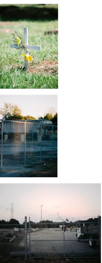
In one image, I focus on the waning evening light that illuminates the fence outside a superfund site (Figure 21). By creating a beautiful image of something that poisons its surrounding
community, I hope to reference how the landscape here has previously been described in luxurious detail without acknowledgement of the immense suffering borne on the land.
Light is a central force in how I represent the landscape. When making the images, I shot almost exclusively right before sunrise or during the late afternoon. During these times of day, the light is at its most gentle (Figure 22) and most dramatic (Figure 23), respectively. I made this decision to “revere” the landscape. Often, these scenes of landscape intervention, pipeline
digging, pine logging, and bio-mass production, are “ugly” – harsh and visually incoherent; I did not want to make ugly images. By making images of these sites of violence during only two parts of the day, it became a pilgrimage. I would wake up at 3:30am to be in position to make a
photograph before the sun broke over the eastern-most row of pine trees. Then, I spent the middle of the day waiting for the next light, driving around, making a few images, but mainly just looking (closely). After I made my photographs in the late afternoon light, I would drive back to Chapel Hill in the dark. The feeling of pilgrimage reinforced the reverent landscape.
I chose to photograph in color to bring the images into the now. Black and white very
obviously references history and the past, and I wanted to ensure that the photographs feel
contemporary in order to illustrate the immediacy of this continued environmental racism. That
being said, color film is not racially neutral. For many decades after color film was introduced,
color matching was done based off of a “Shirley card”. This card, named after the white woman
it portrayed, was printed along with every batch of film. Its purpose was for color matching, adjusting highlight and contrast, and color balancing; because “Shirley” was white, printing was optimized for white skin tones. Though Kodak began incorporating black women into “Shirley cards” in the 1990s, the issue of rendering race equally correct on film is still not remedied.
52When my grandfather died a few years ago, he left me all of his film cameras and equipment. I decided to use film for this project in order to shoot with these cameras, in particular his cannon A-1. (A few images were shot with a 4x5” Speed Graphic field camera, not belonging to him.) My grandfather was an avid environmentalist, but he cared about the landscape for the sake of its beauty and was never concerned with how populations who didn’t look like him (or whose bank accounts did not look like his) are most affected by destruction of and damage to the
environment. By using his equipment, I wrestle with this: how to use the tools of this man to look at systems of power that he was happy to uphold.
I pay particular attention to the swamps in my images (Figures 24). On one level, they are the environmental feature most at risk from the effects of the pipeline. Failed erosion control or changes in the turbidity levels could cause the wetlands to die. But on a more conceptually significant level, the swamps have been a site of Black resistance. The swamps in my images are part of The Great Dismal Swamp, which stretches from the eastern seaboard of Virginia down to South Carolina.
“The maroons of the Great Dismal Swamp, a huge entanglement of forested swampland nestled in the northern corner of the southeastern seaboard, asserted, created, and
defended their freedom by establishing some of the largest and most enduring maroon communities ever to exist in the slaveholding U.S. south. The maroons were Black men and women who took flight from, resisted, and disproved the fiction of the authority of the plantation and its borders. By doing so, they threatened the very foundation of U.S.
slavery. They were individuals and groups who fled to the woods and swamps and
52 Mandalit Del Barco, “How Kodak's Shirley Cards Set Photography's Skin-Tone Standard.” NPR, 2014.
formed permanent and impermanent, independent, and resistant, self-governed communities.”
53How might this environmental attack on the swamps serve as a metaphorical backlash against their histories of Black resistance? My photographs of the swamps can function as memorial image, a eulogy made from the pre-trembling of a collapse.
The number of images and repetition of images or symbols within the images (flags, cemeteries) in the final collection of photographs to be exhibited in the show is meant to feel Sisyphean. The past year has been emotionally fraught for me. The work I’ve made in this project and others has felt like rolling a stone up a mountain, only to watch it roll back down at the end of the day. Sometimes it feels like no matter how much we fight white-supremacy in the landscape, we are entirely powerless in comparison to the state legislature or Duke Energy. What power do we as individuals have against the construction of a pipeline?
My map, which is central to the exhibition, tries to make sense this Sisyphean disorder. In the map, I draw power ties (like the ties between the Koch brother’s environmental racism &
their father’s direct opposition to the civil rights movement) as well as geospatial ties (how far houses are from pipeline blast zones and swamps are from toxic waste leaks). Photographs are marked by numbered pins which correspond to numbers on the wall-sized map as a way to connect the contextual information and inform the viewer beyond the image.
During the project, I found that my act of making the photographs served as an act of creative civil disobedience, sometimes even a protest of performance. When I would photograph the pipeline, work (digging, surveying, welding the pipe) would stop. Every single time, the foreman would radio, and some truck would show up to watch and follow me and I walked or
53 Kathryn Elise Benjamin Golden, “Through the Muck and Mire: Marronage, Representation, and Memory in the Great Dismal Swamp” PhD diss., University of California, Berkeley, 2018,
http://digitalassets.lib.berkeley.edu/etd/ucb/text/Golden_berkeley_0028E_17847.pdf.
drove from site to site. I always stayed on land that I was allowed to be on, either eminent
domain or with the permission of neighboring landowners, but nonetheless I was always watched by an employee of Duke or Dominion Energy. My existence in the landscape caused work to slow and demanded that an employee be delegated to my surveillance, instead of actively working to advance the pipeline. Though small, it was passive direct action. In my practice throughout the project, I tried to make work with in a mental framework that “require[s] utopian forms of environmental praxis to help us imagine alternative possibilities, emancipatory projects, and an end to social and environmental destruction at all scales.”
54Some of the images are fragments, devoid of visual context in the landscape. Images of
“purple distances and … great, broad-armed trees marking the graceful curves of the river”
55are situated next to photographs of the nation’s largest bio-mass plant that refuses to use VOC control technology. These contradictions reside within the duplicitous landscape. A cotton field in a county with an economy that still rests on sharecropping is both beautiful and violent.
Where Sally Mann asked of Confederate battlefields: “does the earth remember? Do these fields upon which unspeakable carnage occurred … bear witness in some way?” I respond – yes. All landscapes remember. The land still holds traces of the blood, remainders of carbon.
Trees hold the lead bullets in their trunks. It is us who forget.
54 Nik Heynen, James McCarthy, Scott Prudham, and Paul Robbins, ed, Neoliberal Environments: False Promises and Unnatural Consequences, (Routledge, New York, 2007), 291.
55 Devereux, 2.