Lincoln
University
Digital
Thesis
Copyright
Statement
The
digital
copy
of
this
thesis
is
protected
by
the
Copyright
Act
1994
(New
Zealand).
This
thesis
may
be
consulted
by
you,
provided
you
comply
with
the
provisions
of
the
Act
and
the
following
conditions
of
use:
you
will
use
the
copy
only
for
the
purposes
of
research
or
private
study
you
will
recognise
the
author's
right
to
be
identified
as
the
author
of
the
thesis
and
due
acknowledgement
will
be
made
to
the
author
where
appropriate
you
will
obtain
the
author's
permission
before
publishing
any
material
from
the
thesis.
Green, Grey or Green-‐Grey?
Decoding infrastructure integration and implementation for
residential street retrofits.
A thesis submitted in partial fulfilment of the requirements for the Degree of Master of Landscape Architecture
at
L I N C O L N U N I V E R S I T Y New Zealand
by
K S E N I A I. A L E K S A N D R O V A
Lincoln University 2016
A B S T R A C T
New-‐world countries are often characterized by large areas of sprawling post-‐war suburban development. The streets of these suburbs are often criticized for being unattractive transport corridors that prioritize cars at the cost of the pedestrian environment and ecological health of their neighbourhoods. Green infrastructure (LID) street retrofits, as well as grey infrastructure-‐dominated traffic calming schemes have been used as partial solutions to the adverse effects of post-‐war street design. There is, however, a lack of implementation of these measures, along with some confusion as to what is defined as green and grey infrastructure at the street scale. The level to which these schemes are integrated with one another is also unclear.
This paper is based on an international English-‐language systematic review of academic peer-‐ reviewed literature of built infrastructure elements within residential street settings. The review reports on a body of evidence-‐based literature, discussing the definitions of green and grey infrastructure at the street scale; along with the barriers and enablers to the implementation of green and grey infrastructure, and the level to which the two are integrated. Barriers and enablers to the successful design and implementation of green and grey infrastructure in residential streets are also investigated.
The physical components of the various infrastructure elements were used to categorize them in order to clearly define the terms green and grey infrastructure within streets. Evidence suggests that there are two ways in which integration of green and grey infrastructure occurs, however only a third of the papers report on green and grey infrastructure integration. Results also show that cost, spatial constraints and resident perception are the most common barriers to the implementation of green and grey infrastructure retrofits in residential streets. Ways to utilize the known barriers and enablers, along with design considerations, are discussed.
The findings presented in this thesis are aimed to provide academics and practitioners with an important series of considerations to help influence the design of street retrofits that achieve a multiple number of social and ecological benefits within a residential setting; in order to help address the adverse social and ecological effects of urbanization and unsustainable post-‐war development patterns.
K E Y W O R D S
Green infrastructure, Retrofits, Suburban, Streets, Integration, Barriers, Enablers, Implementation, Street design, Infrastructure elements, Street infrastructure, Landscape services
C O N T E N T S
A B S T R A C T ... II
C O N T E N T S ... III
T A B L E S A N D F I G U R E S ... V
I N T R O D U C T I O N ... 1
1.1 P R O B L E M S T A T E M E N T ... 1
1.2 R E S E A R C H Q U E S T I O N S A N D O B J E C T I V E S ... 2
1.2.1 Research Questions ... 2
1.2.2 Research Objectives ... 2
1.3 O R G A N I S A T I O N O F T H E S I S ... 2
L I T E R A T U R E R E V I E W ... 3
2.1 B A C K G R O U N D ... 3
2.1.1 Why is the improvement of streets important? ... 3
2.1.2 Landscape Services – a shift in the perception of street infrastructure ... 3
2.1.3 Historic background of infrastructure ... 4
2.1.4 Defining green and grey infrastructure in streets ... 4
2.2 R E S I D E N T I A L S T R E E T S T H R O U G H H I S T O R Y ... 6
2.2.1 Roman streets ... 6
2.2.2 First suburban streets ... 7
2.2.3 First suburban streets retrofitted for contemporary use ... 8
2.2.4 Residential streets of the private car era ... 9
2.3 R E T R O F I T T I N G ... 12
2.3.1 The case for retrofitting post-‐war suburbs ... 12
2.3.2 Retrofitting the suburban streets ... 12
2.4 D E S I G N A N D I M P L E M E N T A T I O N ... 16
2.4.1 Known barriers to implementing more landscape services in streets ... 16
2.4.2 Enablers to implementation of multiple landscape services ... 16
M E T H O D S ... 18
3.1 R E S E A R C H D E S I G N ... 18
3.2 N A R R A T I V E L I T E R A T U R E R E V I E W ... 18
3.3 S Y S T E M A T I C L I T E R A T U R E R E V I E W ... 19
3.3.1 Inclusion criteria ... 20
3.3.2 Searching strategy ... 21
3.5 L I M I T A T I O N S O F M E T H O D O L O G Y ... 25
R E S U L T S ... 26
4.1 D E F I N I T I O N S A N D F U N C T I O N S ... 26
4.1.1 Components ... 26
4.1.2 Functions ... 26
4.2 I N V E S T I G A T I N G T H E A C A D E M I C L I T E R A T U R E ... 28
4.2.1 Geographic distribution ... 28
4.2.2 Methods, Research questions and professional affiliation ... 29
4.3 I N T E G R A T I O N ... 31
4.3.1 Street-‐scale integration ... 31
4.3.2 Element-‐scale integration ... 32
4.3.3 Integration patterns ... 33
4.4 B A R R I E R S A N D E N A B L E R S ... 34
4.4.1 Barriers and Enablers for Green Infrastructure ... 34
4.4.2 Barriers and Enablers for Green-‐Grey Infrastructure ... 35
4.4.3 Barriers and Enablers for Grey Infrastructure ... 36
D I S C U S S I O N ... 37
5.1 D E F I N I T I O N S A N D F U N C T I O N S ... 37
5.1.1 Definitions ... 37
5.1.2 Functions ... 37
5.2 W H A T I S K N O W N A B O U T T H E B O D Y O F L I T E R A T U R E ? ... 38
5.2.1 Geographic distribution and infrastructure types ... 38
5.2.2 Research questions and professional affiliations ... 38
5.2.3 Relevance to Practice ... 39
5.2.4 Use of case studies when designing street retrofits ... 39
5.3 I N T E G R A T I O N ... 39
5.4 B A R R I E R S A N D E N A B L E R S ... 41
5.4.1 How could the barriers to implementation be overcome? ... 41
5.4.2 Considerations for the design of suburban street retrofits ... 42
C O N C L U S I O N ... 43
R E F E R E N C E S ... 45
A P P E N D I X A ... 53
A P P E N D I X B ... 54
A P P E N D I X C ... 55
T A B L E S A N D F I G U R E S
I N T R O D U C T I O N
1.1 P R O B L E M S T A T E M E N T
Well-‐designed residential streets are integral to the health and well-‐being of their surrounding communities (Dover & Messengale, 2013).
Suburban streets in New World countries built after the second world war have often been designed to prioritize vehicle movement and parking (Guo, Rivasplata, Lee, Keyon, & Schloeter, 2012). This has lead to significant negative social, ecological and economic impacts, including declining population health due to inactivity (de Nazelle et al., 2011; Garceau et al., 2013), reduced on-‐road air quality (Colvile et al., 2004) and a cycle of debt and car dependence (Dobson & Sipe, 2008; Horner, 2008). Within the historically wide carriageways of New-‐World suburban thoroughfares (Southworth & Ben-‐ Joseph, 2003) lies an opportunity to improve the streets through retrofitting them (Després, Brais, & Avellan, 2004; Girling & Helphand, 1997; Novotny, 2013), and integrating green and grey
infrastructure elements which have the ability to provide a multitude of services that benefit surrounding residential communities.
Some of the functions provided by green infrastructure elements within streets include fostering and improving citizen health (Annear, Cushman, & Gidlow, 2009), increased aesthetic and economic value within neighbourhoods (Brander & Koetse, 2011; Kong, Yin, & Nakagoshi, 2007) and improved air quality (Hofman, Stokkaer, Snauwaert, & Samson, 2013; Nowak & Crane, 2002). Multiple
functions provided by grey infrastructure elements within streets include accommodation of various forms of transit (Selberg, 1996), accommodation of social interaction (May, Tranter, & Warn, 2008) and provision of basic services such as water conveyance, electricity and communication (Costello, Chapman, Rogers, & Metje, 2007).
However, historically, the design of these systems has been advanced by different disciplines and municipal departments (Després et al., 2004; Karndacharuk, Wilson, & Dunn, 2014), and they are often seen as competing land uses (Tjallingii, 2003). Little is known about the extent to which multiple functions are being incorporated into street retrofits, or the barriers and enablers to designing and implementing integrated green and grey infrastructure into residential streets.
1.2 R E S E A R C H Q U E S T I O N S A N D O B J E C T I V E S
1.2.1 Research Questions
1) What are the definitions and functions of infrastructure elements identified as green and
grey infrastructure within residential streets?
2) What is known about the academic literature on green and grey infrastructure within
residential streets?
3) How is green and grey infrastructure integrated within residential streets?
4) What are the barriers, enablers and considerations for the design and implementation of
green and grey infrastructure in streets?
1.2.2 Research Objectives
1) To examine functions and determine the definitions for infrastructure defined as green and
grey in the context of residential streets:
a) To develop a framework for defining various infrastructure at the street scale
b) To investigate what functions the various types of infrastructure serve within a street
2) To investigate what is known about the academic literature on green and grey infrastructure
within residential streets, in particular:
a) Geographic distribution
b) Study settings
c) Topics studied
d) Disciplinary scope
e) Potential relevance of research to practice
3) To investigate the integration of green and grey infrastructure within residential streets:
a) To investigate how integration is happening at the street scale
b) To investigate which types of infrastructure are integrated
4) To discuss barriers, enablers and considerations for the design and implementation of green
and grey infrastructure into suburban streets.
1.3 O R G A N I S A T I O N O F T H E S I S
Chapter 2 provides a narrative literature review on 1) relevant concepts such as green infrastructure and landscape services, 2) history of residential streets and 3) current knowledge such as known barriers to implementation.
Chapter 3 describes the research design and methodology.
Chapter 4 describes the results of the review
Chapter 5 discusses key findings in relation to the research questions.
Chapter 6 concludes with some suggestions for future research.
L I T E R A T U R E R E V I E W
2.1 B A C K G R O U N D
2.1.1 Why is the improvement of streets important?
Streets are an integral part of a residential neighbourhood’s urban and social fabric; they are places where people walk, socialize and where children play (Barnett, 1982; Jacobs, 1961; Krier, 2003; Lynch, 1960; Spreiregen, 1965). They form a stage for the neighbourhood’s public life, and residents often identify themselves by the street on which they live (Girling & Helphand, 1994). Streets are also conduits for traffic (wheeled and pedestrian), parking and a multitude of services above and below the ground (Girling & Helphand, 1994; Spatari, Yu, & Montalto, 2011).
2.1.2 Landscape Services – a shift in the perception of street infrastructure
Landscape Services is a framework which has recently stemmed from the widely used and recognised Ecosystem Services Framework (Bastian, Grunewald, Syrbe, Waltz, & Wende, 2014; Termorshuizen & Opdam, 2009). Ecosystem services are defined as benefits that humans derive from ecosystems (De Groot, Wilson, & Boumans, 2002; MEA, 2007). The ecosystem services framework is a tool used to regulate sustainable use of natural resources. First conceived in the 1990’s and developed over the last two decades, the Millennium Ecosystem Assessment (MEA, 2007) has helped to evolve the concept considerably, with internationally-‐recognized online information guides such as TEEB (TEEB, 2010) making the ecosystem service classification system publically available. However, despite its popularity and frequent application, the concept of Ecosystem Services is still evolving and is not without weakness (Seppelt, Dormann, Eppink, Lautenbach, & Schmidt, 2011). It has been criticized for its lack of focus on the cultural and social aspects as well as its failure to integrate man-‐made systems and interactions (Valles-‐Planells, Galiana, & Van Eetvelde, 2014).
The concept of landscape services was created then many researchers found the ecosystem services too restricting, and isolated in its focus on solely natural systems as well as the limited focus on the ‘cultural’ category, making it less appropriate for disciplines that look at urban settlements as an integrated system. In contrast to the commonly used ecosystem services classification systems such as the MEA and TEEB, the landscape services as described by Valles-‐Planells et al. (2014) has a more balanced distribution of service categories. The classification system developed by Valles-‐Planells et al. (2014) is the result of a critical evaluation of the five most accepted ecosystems frameworks, which resulted in the addition of several categories that better represent the complex nature of urban environments and the services provided by both natural and man-‐made systems, all of which support our livelihoods. Urban ecosystems are inherently modified and fragmented, and comprised of a wide array of elements (Gómez-‐Baggethun & Barton, 2013). Taking this view to the street scale, a suburban street can be viewed as a complex system where a multitude of elements, both natural and man-‐made, provide a wide variety of functions. The landscape services concept can be a powerful tool in helping us understand and explore the variety of functions complex urban environments provide for human needs.
2.1.3 Historic background of infrastructure
The term ‘infrastructure’ has always been commonly defined as ‘the basic systems and services, such as transport and power supplies, that a country or organization uses in order to work effectively’ (Cambridge Dictionary, 2015). This definition would include examples such as a city’s electricity, wastewater, sewage, and road systems. Infrastructure in residential streets provides vital, yet very specific services (wastewater regulation, transport movement, electricity provision etc.), which are single-‐function human-‐engineered systems. When movements such as the ecosystem services concept were advanced (MEA, 2007), they championed an increased understanding of the multiplicity of essential services that natural systems provided to humans. Added to primarily human-‐engineered systems, this understanding expanded the concept of infrastructure to include a wider range of elements than those that have been historically included into the definition.
2.1.4 Defining green and grey infrastructure in streets
Although the term Green Infrastructure first appeared in planning discourse in mid 1990’s, it was
often used to describe planning approaches which have already been utilized for some time (Wright, 2011). Benedict and McMahon were among the first authors to define ‘Green Infrastructure’ (see Table 1.1 below). Many authors have since defined the term, and its definition has been a somewhat contested topic (Davies et al., 2006; Matthews, Lo, & Byrne, 2015; Mell, 2012; Wright, 2011) with a myriad of alternative descriptions provided at a variety of spatial scales. The table below shows some of the most widely referenced definitions of Green Infrastructure in the past decades.
Author (year) Definition
Benedict and McMahon (2006)
Green infrastructure is an interconnected network of waterways, wetlands, woodlands, wildlife habitats and other natural areas; greenways, parks and other conservation lands; working farms, ranches and forests; and wilderness and other open spaces that support native species, maintain natural ecological processes, sustain air and water resources and contribute to the health and quality of life for (American) communities and people.
Kambites and Owen (2006)
Green infrastructure is taken, therefore, to encompass connected networks of multifunctional, predominantly un-‐built, space that supports both ecological and social activities and processes.
Tzoulas et al. (2007) It can be considered to comprise of all natural, semi-‐natural and artificial networks of multifunctional ecological systems within, around and between urban areas, at all spatial scales.
Ahern (2007) Green infrastructure is an emerging planning and design concept that is
principally structured by a hybrid hydrological/drainage network, complementing and linking relict green areas with built infrastructure that provides ecological functions
United States Environmental Protection Agency (2014)
An adaptable term used to describe an array of products, technologies, and practices that use natural systems -‐ or engineered systems that mimic
natural processes -‐ to enhance overall environmental quality and provide utility services. As a general principal, Green Infrastructure techniques use soils and vegetation to infiltrate, evapotranspirate, and/or recycle stormwater runoff.
Table 2.1.4 Commonly referenced definitions of Green Infrastructure
Benedict and McMahon refer to Green Infrastructure from a balanced perspective (both
Green Infrastructure in the same year, present a similarly balanced view to Benedict and McMahon in that Green infrastructure is a network, and supports both ecological and social activities and processes. They also, however, specifically mentioned in their definition that this network is multifunctional. Tzoulas et. al. (2007) viewed green infrastructure from a much more eco-‐centric perspective, their definition focusing more so on the natural or artificial systems and their connectivity. Their definition, much like that of Kambites and Owen, mentioned to the
multifunctionality of green infrastructure. Tzoulas et. al. also alluded to green infrastructure as separate from the built form, more so as something which is superimposed into, between or around urban areas. Despite some differences, all three of the above definitions view Green Infrastructure at a broad planning scale as a connected system of open space and ecological systems which support human life.
Ahern discussed Green Infrastructure in a much more specific sense that the three previous authors, describing it not as a network but as a planning and design concept, alluding to a rather specific hydrological and drainage functions, as well as the more general provision of ecological values. The United States Environmental Protection Agency (USEPA) defines green infrastructure even more specifically, describing it as products and technologies that mimic natural processes. Aside from Tzoulas et.al. (2007), none of the above authors allude to the man-‐made or artificial nature of some green infrastructure in their definitions. USEPA also describe green infrastructure as a concept used to primarily address drainage issues, displaying a hydrological focus similar to that of Ahern; but more targeted and at a finer scale. While this these differences in definitions could be due to the varying scale of focus of the different authors, it shows the breadth and ambiguity of the term ‘Green Infrastructure’ in various planning contexts.
While several authors argue that the lack of a clear definition of Green Infrastructure has detrimental effects on its successful implementation (Matthews et al., 2015; Sandström, 2002), it has also
become evident that a singular definition for all scales in not possible or helpful for such a broad and multi-‐disciplinary term (Mell, 2012; Wright, 2011). Both authors, however, agree that clearly defining the terms within specific contexts is an important step of clearly understanding the built
environment of a project and it’s goals. The more recent use of the term ‘green infrastructure’ to describe vegetated stormwater management systems such as bioswales and rain gardens (United States Environmental Protection Agency, 2014) reflects current concerns with respect to water, however it restricts the term to defining only one type of infrastructure element and only a few functions.
In contrast to green infrastructure, the term ‘grey infrastructure’ is only mentioned within academic literature when scholars are attempting to define green infrastructure and how it relates to
conventionally defined infrastructure. Within this context, the term ‘grey infrastructure’ is most commonly used to define all other infrastructure that is not visually ‘green’ or living. The physical composition and appearance of an infrastructure element (a physical element/component within a street setting) is often a major contributing factor to how members of the public, as well as
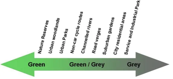
Mell (2012) suggests that the subjectivity of this approach can often lead to ambiguity and vagueness in communication amongst the various stakeholders and disciplines involved in implementing green infrastructure projects. In response to these considerations, Davies et al. (2006) have proposed a way of categorising infrastructure elements using a continuum that identifies whether infrastructure elements can be identified as more ‘green’ or ‘grey’ in a particular setting.
Figure 2.1.4 The Green-‐Grey Continuum created by Davies et al. (2006)
Each infrastructure element’s components (living or man-‐made) are analysed against it’s function (benefitting humans or ecological systems), and depending on a combination of these factors the infrastructure element is placed along the continuum. Davies’ approach is valuable in that can be used at a multitude of scales. The inclusion of both components and functions in defining
infrastructure elements provides a more balanced view when defining what is green infrastructure and what is grey. Unfortunately, Davies’ (2006) method of defining green and grey infrastructure is still subjective in part. In Davies’ study, workshop participants decided which functions of elements would be attributed to green infrastructure and which to grey. At the street scale, there is still a lack of a clear and replicable system for defining green and grey infrastructure.
2.2 R E S I D E N T I A L S T R E E T S T H R O U G H H I S T O R Y
A street is commonly defined as ‘a road in a city or town that has buildings that are usually close together along one or both sides’ (Cambridge Dictionary, 2015). In this thesis, the boundary of a street is defined by the legal boundaries of the adjacent property, and includes everything within the legal street boundary (also known as ‘right of way’ or ROW); including grassed or planted berms, sidewalks and sometimes encroaching fences. Adjacent buildings are not included as components of the street in this research. The streets of interest in this research are those located in first-‐world countries, including the U.S., Canada, Australia, New Zealand and several European countries. Third-‐ world countries were excluded from this review due to the marked difference in development patterns.
2.2.1 Roman streets
general section of these city streets, although often simplified, can also be seen in many medieval cities.
Figure 2.2.1 Typical section of a 15 BC Roman city street based on Southworth and Ben-‐Joseph (2003).
Table 2.2.1 Landscape services provided by 15 BC Roman city streets
The lack of technological advancements and requirement to accommodate over-‐ground and underground services at the time of construction means there was less pressure to provide extra space for these, allowing the streets to remain relatively small in scale for centuries. These streets in historic centres today create successful pedestrian-‐oriented environments which support social interaction, and have been found to contribute to liveable and vibrant neighbourhoods by a number of influential urban design theorists (Dover & Messengale, 2013). The small scale and simplicity of these streets also meant that they were often riddled with congestion and sanitation problems, as there was often a lack of effective drainage or sewerage (Southworth & Ben-‐Joseph, 2003). Although the intimate scale of these streets has been known to provide a comfortable and attractive
pedestrian environment, in many countries today the replication of these streets of such scales may be difficult or inappropriate due to various spatial requirements such as minimal required widths of vehicle carriageways and footpaths, the need for utility strips and emergency vehicle access.
2.2.2 First suburban streets
the elite social classes, and had very wide streets designed for smooth carriage rides. They provided a pleasant contrasted to the pollution and congestion of the city streets of the era (Southworth & Ben-‐Joseph, 2003). Commissioned in 1904 London, Hampstead Garden was the first suburb designed for a mix of social classes, and the first to actively include cul-‐de-‐sacs into its planning. With the arrival of the motorcar partway through the suburb’s conception, the designers predicted that creating several cul-‐de-‐sacs which were connected by a pedestrian network would be a good way to ensure the residential streets remain quiet and liveable in the times to come. Southworth and Ben-‐ Joseph (2003) describe Hampstead Garden as one among the first suburbs to develop smaller-‐scale streets, although these were still much wider than old Roman streets.
Figure 2.2.2 Typical section of original street in Hampstead Garden based on Southworth and Ben-‐ Joseph (2003).
Table 2.2.2 Landscape services provided by the original streets of Hampstead Garden
The streets had gravel surfaces and featured no curbs or spatial separation between vehicle and pedestrian movement. They were lined with trees set within grass verges, and were bordered by low fences and facades of dwellings (Southworth & Ben-‐Joseph, 2003).
2.2.3 First suburban streets retrofitted for contemporary use
accessible to all residents as they would be in a typical post-‐war suburb, Hampstead Garden remains one of the most desirable places to live in London.
Figure 2.2.3 Typical section of updated street in Hampstead Garden based on Southworth and Ben-‐ Joseph (2003).
Table 2.2.3 Landscape services provided by the retrofitted streets of Hampstead Garden
Although the streets of Hampstead Gardens have been adapted to cars over the last century, they have largely retained their relatively small spatial scale and abundant vegetated elements. While the pervious cover of the streets has been reduced from the original streets of the 1900’s, they have also been retrofitted to serve an increased number of landscape services required by modern lifestyles.
2.2.4 Residential streets of the private car era
The increasing availability of automobiles has gradually changed society’s expectations and demands for the way streets were designed in cities (Karndacharuk et al., 2014), with efficient traffic
movement being commonly seen as their primary function. Streets became wider, harder and increasingly complex, becoming conduits for faster and heavier traffic as well as effective conveyance of underground and overground services necessitated by surrounding development (Girling &
the first standardized suburban design development principles emerged, including street design standards, that became the foundations for most post-‐war suburban streets (Southworth & Ben-‐ Joseph, 2003).
In the United States, the widths of vehicle carriageways built in the 30s and 40’s varied from of about 6.7-‐12 meters with curbs either side, a planting/ utility strip, a footpath (although optional) and trees planted along the property edge of the footpath. In colder climates with heavy winter snowfalls, even more room was allocated to create appropriate clearance between cars, space for storage of snow and for the safe passage of snow ploughs (ASCE, NAHB, & ULI, 1974). Trees and verges were used primarily as a decorative element in the street. The trees, which were historically placed between the footpath and the road, were now being placed between the footpath and the adjoining property. This was because the removal of vertical elements alongside the carriageway was believed to reduce the severity of minor crashes.
Figure 2.2.4 Typical section of post-‐war suburban street based on Southworth and Ben-‐Joseph (2003).
Table 2.2.4 Landscape services provided by post-‐war suburban streets
obstacles and increasing road width made it safer (Dumbaugh, 2005). However, large road widths are now known to be one of the main factors in car accidents occurring on residential streets (Dumbaugh & Rae, 2009; Gårder, 2004; Leaf, Preusser, & United, 1999; Rosén, Stigson, & Sander, 2011).
In recent years, the excessive width of suburban streets has also been linked to car dependence, and
a decrease in the use of other, more sustainable modes of transport (Dumbaugh & Li, 2010; Gårder,
2004; Leaf et al., 1999). Environments designed primarily for car use were based on the assumption that the residents could maintain ownership of a vehicle; disregarding that limited access to a motor vehicle or public transport could result in social isolation (Dobson & Sipe, 2008). Garceau et al. (2013) found that car dependence was correlated with increased human obesity due to physical inactivity, as most walking-‐distance journeys were now being taken by car. Cars are also considerable
generators of air pollution in cities, a major contributor to illness and death, particularity during heat waves (Kim, Deo, Chung, & Lee, 2015). Furthermore, carbon dioxide emissions are a significant contributor to climate change.
The increased width of streets and associated sprawling development also meant a significant increase of impervious cover (mainly asphalt), which has been widely accepted to contribute to increased stormwater run-‐off (Jennings & Jarnagin, 2002), urban flooding (Liu, Chen, & Peng, 2014) and significant reduction in water quality of nearby waterways (Carle, Halpin, & Stow, 2005). The traditional stormwater management systems designed to collect and convey is often unable to cope with increased rainfall volumes, resulting in overflows and significant water pollution. The inclusion of trees and other vegetation into the public right-‐of way was primarily for decorative purposes, and the space dedicated to these elements was not sufficient to offset the high impervious cover of a street.
2.3 R E T R O F I T T I N G
2.3.1 The case for retrofitting post-‐war suburbs
Retrofitting means installing elements that were not available during the original installation (Dunham-‐Jones & Williamson, 2009). Over the years, the post-‐war suburbs created a double-‐edged sword – an unsustainable housing typology favoured by the residents and sprawling areas of out-‐ dated and car-‐dependent infrastructure (Forsyth, 2012; Girling & Helphand, 1997; Moos & Mendez, 2014).
Ageing housing stock and infrastructure has caused a gradual migration of residents from post-‐war inner-‐ring American suburbs to either the city or to new outlying developments in several American cities which started in the 1990’s (Lee & Green leigh, 2005). This trend has been described by a number of authors (Cooke, 2013; Després et al., 2004; Forsyth, 2013), as inner-‐ring suburbs are left vulnerable to financial downturn (Cooke, 2013), increases in poverty and crime (Lee & Green leigh, 2005) and crumbling infrastructure (Church, 2014). The re-‐introduction of multiple landscape services (functions) into streets of dilapidated neighbourhoods using retrofits is not new; it is a valuable approach to reviving auto-‐centric suburban and ex-‐urban sites (Dover & Messengale, 2013).
2.3.2 Retrofitting suburban streets
Street retrofits that are focused on calming traffic and enhancing the social life of streets are numerous (Karndacharuk et al., 2014), as are studies of street elements aimed at improving natural drainage, biodiversity value or aesthetics (Church, 2014; Joan Iverson Nassauer, 2011; Joan Iverson Nassauer, Wang, & Dayrell, 2009; Nickel et al., 2013).
At the street scale, one of the first movements to improve residential streets in the era of the motor car was conceived in the late 1950’s, with Colin Buchanan’s idea of shared streets, where traffic was slowed by various design elements and pedestrians could co-‐exist safely with cars. The design of shared streets looked to actively increase the dominance of the pedestrian within a residential street, while creating a safe and attractive environment that still accommodated slow movement of
vehicles. The idea has been widely adopted and developed in the Netherlands as ‘woonerven’
(Karndacharuk et al., 2014) and in several other European countries since its early conception. In first-‐world countries struggling with vehicle dominance, variations of similar ideas such as traffic calming (UK 1970’s, US 1980’s), Living streets (International), Local Area Traffic Management (NZ), and Home Zones (UK) have also been widely adopted by engineers, urban planners and regulatory agencies from the 1970’s onwards. These ideas are commonly applied to street retrofit projects.
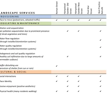
Figure 2.3.2 Section elevation of best practice suburban street retrofit based on Southworth and Ben-‐ Joseph (2003).
Table 2.3.2 Landscape services provided by best practice suburban street retrofit
The use of green infrastructure elements within street designs has been found to provide more landscape services than the traditional singular decorative role of street trees and planting. The inclusion of vegetated stormwater elements and permeable pavements in street designs has been increasingly used to address stormwater issues (Ahiablame, Engel, & Chaubey, 2013; Qin, Li, & Fu, 2013) whilst also increasing biodiversity in neighbourhoods (Kazemi, Beecham, & Gibbs, 2011). The use of trees and planting has also been shown to reduce air pollution and sequester carbon (Kiss, Takács, Pogácsás, & Gulyás, 2015), as well as providing climatic comfort (Coutts, White, Tapper, Beringer, & Livesley, 2015).
traditional water infrastructure, while removing harmful pollutants from impervious-‐surface run-‐off (Chapman & Horner, 2010; Qin et al., 2013). The inclusion of well-‐designed vegetated elements within a street has also been linked to improved aesthetics (Church, 2014), increased property value (Brander & Koetse, 2011; Kong et al., 2007), a stronger sense of custodianship among residents (Church, 2014) and the ability to sequester atmospheric carbon (Yang, McBride, Zhou, & Sun, 2005).
Encouraging more active modes of transport such as walking and cycling through street design can result in improved mental and physical health of residents (Badland & Schofield, 2005; Van Dyck, Cardon, Deforche, Owen, & De Bourdeaudhuij, 2011), increased social capital (Bain, Gray, & Rodgers, 2012; May et al., 2008) improved street and neighbourhood safety (Mueller et al., 2015) and reduced automobile crash rates (Dumbaugh, 2005). The decrease in inactive and sedentary lifestyles linked to car-‐dependence has been found to have a positive effect on government expenditure on healthcare (Annear, 2008). Less cars on the streets means less toxic exhaust emissions, which, in turn, leads to cleaner air (May et al., 2008), and reduced numbers of vehicles means less reliance on fossil fuels for everyday livelihoods, coupled with greater resilience in times of wavering fuel security (Badland & Schofield, 2005; Garceau et al., 2013).
Table 2.3.3 Landscape services provided by streets through time
Figure 2.3.4 Evolution of residential street layouts through history. Indicative plans based on Southworth and Ben-‐Joseph (2003). Scale varies (see dimensions).
Over the centuries, residential streets have grown in scale; and evolved to become complex systems that serve a much wider range of functions than the very first roman streets. Streets have become increasingly complex through time. Many streets built today still have the same general profile as the post-‐war suburban streets of the 50’s, although many contemporary developments are building these to narrower widths.
Figure 2.3.5 Indicative plans of typical suburban street and a best -‐ practice suburban street retrofit based on Southworth and Ben-‐Joseph (2003). Not to scale.
The contemporary best-‐practice retrofitted street strives to perform more functions than streets have ever done historically, whilst fitting into the same or at times smaller right-‐of way than the suburban streets of the post-‐war motor age. With the advance of research, technology and well-‐ applied design, street retrofits have the capacity to address the social, cultural and environmental problems brought on by previous unsustainable development patterns.
2.4 D E S I G N A N D I M P L E M E N T A T I O N
2.4.1 Known barriers to implementing infrastructure in streets
At the city planning scale, Tjallingii (2003) and Svendsen, Northridge, and Metcalf (2012) explore the tension between ‘grey’ infrastructure (referred to as red infrastructure by Tjallingii) such as roading and housing; and ‘green’ infrastructure (forestry, parks, nature conservation, agriculture) within urban and semi-‐urban contexts. Tjallingii describes the tendency for Green planning advocates to take defensive and even offensive approaches to securing room for green space development. This trend is explained as being primarily due to a lack of space in cities, with ‘green’ structure planning often being dominated by ‘red’ infrastructure. Tjallingii speculated that this was often due to red structure carrying the promise of economic gain. Svendsen et al. (2012), Sandström,
Angelstam, and Khakee (2006) and Sandström (2002) describe a similar pattern, where grey infrastructure is so often favoured over green infrastructure when planning decisions are made.
Two of the major reasons for the lack of prioritization of green infrastructure are definition ambiguity and a pattern of path dependence amongst governments (Matthews et al., 2015; Sandström, 2002). Path dependence relates to the tendency of governments to continue doing things the way they have been done, and a reluctance to integrate new knowledge and change processes. Several researchers describe a lack of definition clarity and understanding of green infrastructure within government documents as one of the biggest barriers to the implementation of green schemes at the city scale (Matthews et al., 2015; Wright, 2011).The definition ambiguity has, in many ways, led to a re-‐labelling of existing open space as ‘green infrastructure’ and, in turn, has resulted in many governments precluding the development of truly functional, integrated and connected green infrastructure planning and implementation (Sandström et al., 2006). Olorunkiya, Fassman, and Wilkinson (2012) also suggest that much of the uncertainty in relation to green infrastructure has been due to a lack of understanding and knowledge of its effectiveness.
Streets with increased landscape services require input from a multitude of disciplines, and trade-‐ offs between functions. This makes the design process complex as many divisions within
municipalities operate independently from each other, making it difficult for them to design
successful streets in a collaborative way (Després et al., 2004; Karndacharuk et al., 2014). Aside from this, the pressure to address a variety of problems often comes at a cost (Forsyth, 2005) and the task of accommodating a multitude of functions and elements within a space which cannot be too large can create formidable design challenges (Bain et al., 2012). Despite the above issues discussed by a number of authors, it is unclear what comprises the most commonly encountered barriers during the design and implementation of green and grey infrastructure at the street scale. A thorough analysis of the key barriers to the design and implementation to various infrastructures in streets could lead to a better understanding of how these barriers could be overcome.
2.4.2 Enablers to implementation of multiple landscape services
While exploring the tensions between green and grey infrastructure at the city scale, Tjallingii (2003) discussed another approach. This involved green structure planning potentially acting as an
disciplinary dialogue to take place. Within the street context Karndacharuk et al. (2014) describes a similar idea, expressing the need for multiple professions involved with the creation, renewal and maintenance of streets to work collaboratively in order to create well-‐integrated street designs. Collaborative multi-‐disciplinary approaches to design, could be a key step to the successful design and implementation of more landscape services into streets.
At the street scale, the use of green infrastructure functions to serve the purpose of traditional stormwater infrastructure has been proven effective (Nickel et al., 2013), meaning that over time government expenditure of extensive replacements of underground stormwater pipes could be reduced (Knight, 2003; Nickel et al., 2013). This, coupled with better connectivity and reduced reliance on traditional stormwater infrastructure, has the potential to increase the resilience in times of crisis; and reduce the increasing effects of climate change on human settlements (Matthews et al., 2015). Thoughtful planning and integration of green and grey infrastructure could bring
opportunities to enhance the functionality of both types of infrastructure at the street scale. It is currently unclear if integration of green and grey infrastructure is occurring, and gaining an
understanding of the level and types of integration could shed light on whether integration could be used as a potential enabler to building better streets. It is still unclear what other enablers to the implementation of green and grey infrastructure are encountered at the street scale.
2.4.3 Status of the literature on green and grey infrastructure in streets
In order to investigate the levels of implementation and advancement of green and grey infrastructure in residential streets, it is important to know how the research on the topic of translates into practice, as well as what disciplines are undertaking the research and what the local climatic conditions might be. In their research about the relation of academia and practice of the Landscape Architecture profession, Milburn and Brown (2016) alluded to the fact that academic researchers and practitioners had very different views about what topics were most valuable to research. Most practitioners’ views leaned toward the importance of sustainable design, water management, construction, ecology and plant materials, while the academics producing the research mostly produced studies of theory, history, education, perception and case studies. It is yet
unknown what topics are most commonly studied within research on green and grey infrastructure in streets.