World Maritime University
The Maritime Commons: Digital Repository of the World
Maritime University
World Maritime University Dissertations Dissertations
2006
A cost benefit analysis of the AIS [Automatic
Identification System] system in Sweden
Andreas Westerberg
World Maritime University.
Follow this and additional works at:http://commons.wmu.se/all_dissertations
Part of theEngineering Commons
This Dissertation is brought to you courtesy of Maritime Commons. Open Access items may be downloaded for non-commercial, fair use academic purposes. No items may be hosted on another server or web site without express written permission from the World Maritime University. For more information, please [email protected].
Recommended Citation
Westerberg, Andreas, "A cost benefit analysis of the AIS [Automatic Identification System] system in Sweden" (2006).World Maritime University Dissertations. 145.
WORLD MARITIME UNIVERSITY
Malmö, Sweden
A COST BENEFIT ANALYSIS OF THE AIS SYSTEM
IN SWEDEN
By
ANDREAS WESTERBERG
Sweden
A dissertation submitted to the World Maritime University in partial fulfilment of the requirements for the award of the degree of
MASTER OF SCIENCE
In
MARITIME AFFAIRS
MARITIME ADMINISTRATION
2006
Declaration
I certify that all the material in this dissertation that is not my own work has been
previously identified, and that no material is included for which a degree has previously
been conferred to me.
The contents of this dissertation reflect my own personal views and are not necessarily
endorsed by the University.
(Signature):………..
Date:………
Supervised by: Sven-Åke Wernhult
World Maritime University
Assessor:
Institution/Organization:
Co-assessor:
Acknowledgements
I hereby must start with an appreciation to SIDA (Swedish International Development
Cooperation Agency) for providing the scholarship which gave me the opportunity to
study nine month in this University. Doubtless, the Swedish Maritime Administration and
more specifically Mr Willand Ringborg have to be appreciated because it was his
suggestion that I should study Maritime Administration in WMU this year. I am most
grateful. In addition, I really have to thank my supervisor, Sven-Åke Wernhult for his
helpfulness in leading me through this study, and for always being available to discuss
different features in this work.
Without limitations, this is the right moment to express gratitude to my parents, Ulf and
Agneta Westerberg, and also to my brother Tobias and my sister Frida for always
supporting me, not at least during the process of this particular study. Furthermore, my
old friend Jens who always has been there for me really deserves my appreciation.
During my time in Malmö I have had the opportunity of meeting some new friends, both
from Malmö and from other countries. The time at the hostel would never have been the
same without Evangelos, Anand, Vipin, Umesh and David. Additionally, the time outside
the hostel would never had been the same without my new friend Elin who has given me
her support and always been willing to help me enjoy life in Malmö.
Needless to say my fellow classmates in the Maritime Administration specialization have
supported me and always been available during examinations and assignment
preparations as well as during field studies. Also, in my spare time, I have really
appreciated being part of the WMU community. I wish all my class mates and my other
fellow students of WMU the best in their future lives and hope to keep in contact with
Abstract
Title of Dissertation: A Cost Benefit Analysis of the AIS system in Sweden
Degree: MSc Maritime Administration
The dissertation is a study of the costs and benefits associated with the AIS system in
Sweden and the chosen method is to interview key persons in the SMA and in the SCG
since these authorities are important stakeholders.
First, the topic is introduced and the background to and the purpose of the study are
described. Then the stakeholders themselves are described together with a theoretical
framework consisting of the AIS technology. Also, the reason for how and why a Cost
Benefit Analysis can be a helpful tool while determining if the AIS system is beneficial
in Sweden and contributes to the common welfare in our society is presented.
The results shows that the SMA and the SCG see quite many benefits with the AIS
system; such as enhanced efficiency in SAR operations and that it helps the SCG in their
surveillance of the Swedish coast, and brings lowered fuel costs for ice breakers. But
most benefits are in spoken words and not quantified in terms of saved lives or prevented
accidents where the environment remains unpolluted.
The concluding chapter states that it is hard to determine if the AIS system in Sweden
make some of the stakeholders better off without making some others worse off (a
so-called Pareto improvement in new welfare economics). Several of the respondents
express benefits with the system which are beneficial for safety and environmental
protection but there is a lack of quantitative measures.
More studies need to be conducted to decide if the AIS system is beneficial in monetary
Table of Content
CHAPTER 1 ...1
INTRODUCTION ...1
CHAPTER 2 ...6
METHOD...6
THE CHOSEN PATH... 6
A qualitative approach... 6
LIMITATIONS... 7
THE INTERVIEWS... 7
THE ADDITIONAL DATA COLLECTION... 9
CHAPTER 3 ...10
COST BENEFIT ANALYSIS ...10
Welfare in a society... 10
How to determine the costs and benefits... 12
WHY A CBA ON THE AIS SYSTEM IN SWEDEN? ... 13
AIS TECHNOLOGY AND THE STAKEHOLDERS ...15
AIS–HOW IS IT BEING USED?... 15
THE TECHNIQUE BEHIND – A BRIEF DESCRIPTION... 17
AIS IS MANDATORY... 19
COSTS OF THE AIS... 20
BENEFITS OF THE AIS... 21
VESSEL TRAFFIC SERVICES... 22
Definitions and purpose ... 22
Costs of the VTS ... 23
Benefits of the VTS ... 23
AIS IN THE VTS ... 24
SWEDISH MARITIME ADMINISTRATION... 26
USE OF AIS TECHNOLOGY IN THE SMA ... 26
Coverage of the AIS system in the Baltic Sea... 27
COSTS FOR THE AIS IN SWEDEN... 28
USES AND COSTS OF THE VTS IN THE SMA... 31
COSTS FOR SHIP OWNERS... 31
SWEDISH COAST GUARD AND THE USE OF AIS... 33
COOPERATION IN THE BALTIC SEA REGION... 34
HELCOM ... 34
TRAFFIC SEPARATION SCHEMES... 38
BALTIC ICEBREAKING MANAGEMENT... 38
SAFESEANET... 39
CHAPTER 4 ...41
THE RESULTS ...41
AIS IN THE VTS ... 41
Rolf Zetterberg (Senior Technical Advisor, Swedish Maritime Safety Inspectorate, SMA) ... 41
Björn Lager (VTS Project Manager, SMA)... 44
AIS AND ACCIDENT INVESTIGATIONS... 45
Sten Andersson (Casualty Investigator, SMA: s Safety Inspectorate)... 45
AIS IN SAR OPERATIONS... 46
Ulf Hallström (MRCC, SMA)... 46
AIS AS A NOTICE FOR MARINERS... 47
AIS AND SAFESEANET... 48
Malin Dreijer (nautical administrator, SMA) ... 48
AIS AND ICE BREAKING... 49
Johny Lindvall (Deputy Head of SMA: s Ship Management)... 49
AIS AND HYDROGRAPHICAL SURVEYING... 52
Ulf Lejdebrink (Senior Advisor, Ship Traffic Division, SMA)... 52
AIS AND HYDROLOGICAL INFORMATION... 52
Kjell Johansson (AIS expert, Fairways, SMA)... 52
AIS AND THE SCG ... 53
Thomas Fagö, SCG... 53
CHAPTER 5 ...55
ANALYSIS AND DISCUSSION OF COSTS AND BENEFITS ...55
DESIGN OF AND FOCAL POINTS IN THE CBA OF THE AIS SYSTEM... 55
AIS IN THE VTS(SHIP TO SHORE)... 56
Safety... 56
Saved costs... 56
Effect on marine pollution... 56
AIS AND ACCIDENT INVESTIGATIONS (SHIP TO SHIP) ... 57
Explaining the true chain of events... 57
AIS AS A NOTICE FOR MARINERS... 57
AIS AND SAFESEANET... 58
AIS IN SAR OPERATIONS... 58
Enhanced efficiency ... 58
AIS AND ICE BREAKING... 59
Saved time and enhanced efficiency... 59
Fuel costs ... 59
AIS AND HYDROGRAPHICAL SURVEYING... 59
AIS AND HYDROLOGICAL INFORMATION... 60
AIS AND THE SCG ... 60
HOW TO DETERMINE THE SIGNIFICANCE OF AIS IN ACCIDENT PREVENTION? ... 60
An accident with pollution damage... 61
WHAT ARE THE DIFFICULTIES AND PROBLEMS WITH THE CBA? ... 63
CHAPTER 6 ...64
CONCLUSION PART ...64
Present estimation of the AIS system in the SMA... 64
CBA IN THE SMA AND THE SCG ... 65
The contribution of my study... 65
Suggestions to further studies ... 66
VALIDITY AND RELIABILITY OF THE RESULTS FROM THE STUDY... 66
REFERENCELIST ... 67
APPENDICES ...72
Appendix 1 Specification of costs for OP “Polo M”... 72
Appendix 2 Costs for the VTS centrals in Sweden ... 73
Appendix 3 Locations of the AIS sensors ... 74
Appendix 4 AIS information from Sweden ... 76
Appendix 5 AIS information from HELCOM ... 77
Appendix 6 Information about the status of the Swedish AIS network prior to a coming meeting relating to COMSAR. ... 78
Appendix 7 Interview guide for the key persons in the SMA and the SCG... 81
Appendix 8 Traffic Separation Scheme “Off Falsterbo Rev “ ... 82
List of figures
FIGURE 1PARETO EFFICIENCY (SOURCE: BOARDMAN, GREENBERG, VINING, WEIMER)………..16
FIGURE 2 THE SOTDMA TECHNOLOGY (SOURCE: THE US COST GUARD)………...23
FIGURE 3 BULK CARRIER FU SHAN HAI IS SINKING NORTH OF BORNHOLM (SOURCE: THE SCG)………38
FIGURE 4 THE HELCOM MARINE AREA AND THE BALTIC SEA (SOURCE: HELCOM)………42
FIGURE 5 TRAFFIC SEPARATION SCHEMES IN THE BALTIC SEA AREA (SOURCE: HELCOM)………43
TABLE 1 REPORTING INTERVALS FOR DIFFERENT TYPE OF SHIPS (SOURCE: IALA)………22
TABLE 2 COSTS FOR AIS NETWORK IN SWEDEN (SOURCE: THE SMA)………34
List of Abbreviations
SMA: Swedish Maritime Administration
SCG: Swedish Coast Guard
CBA: Cost Benefit Analysis
PSSA: Particularly Sensitive Sea Area
HELCOM: The Helsinki Commission
IMO: International Maritime Organization
AIS: Automatic Identification System
VTS: Vessel Traffic Service
IDABC: Interoperable Delivery of European eGovernment Services to public
Administrations, Businesses and Citizens
SAR: Search and Rescue Operation
IALA: The International Association of Marine Aids to Navigation and Lighthouse
Authorities
TDMA: Time Division Multiple Access
DSC: Digital Selective Call
GNSS: Global Navigational Satellite System
SOTDMA: Self-Organizing Time Division Multiple Access
ECDIS:
GPS: Global Positioning System
BIM: Baltic Ice breaking Management
BSIS: Baltic Sea Ice Service
EMSA: European Maritime Safety Agency
Chapter 1
INTRODUCTION
The Automatic Identification System (AIS) technology is beneficial and is used in Vessel
Traffic Service (VTS) centrals (ship to shore) and as ship to ship identification system in
the Baltic Sea as well as in other parts of the world. Benefits like the simplification it
brings to identification of vessels carrying the system makes it powerful. This study only
investigates the potential of the AIS system in the hands of the Swedish Maritime
Administration (SMA) and the Swedish Coast Guard (SCG). The use in VTS centrals,
but also other benefits will be presented together with the costs. The joint venture of
Helsinki Commission (HELCOM) is one of the most important organisations caring for
the marine environment in and adjacent to the Baltic Sea. So, there are many efforts to
preserve the Baltic Sea, recently appointed as a PSSA (Particularly Sensitive Sea Area)
by the International Maritime Organisation (IMO). On the other hand, there are several
reasons for shipping activities in the area. Indeed, even the probability for increased trade
in the Baltic Sea- partly due to expected increase in the amount of oil transport- is
beneficial for the economies in the countries surrounding the Baltic Sea.
A good reason for continuous westbound oil transport from the large ports from the Gulf
of Finland is the prize of crude oil. A new record was set on July 8, 2006 when the price
was more than USD75 and 78 cent per barrel for crude oil which will be delivered in
August (Swedish Radio, 2006). But also many other types of cargo vessels represent a
considerably large part of the traffic moving in the area, all year round all around the
clock, now and most probably in the foreseeable future.
The AIS technology is based on the VHF communications network which consists of
transmitter/receiver on ships and ashore. But why does it seem extra beneficial for coastal
states in their effort of trying to monitor traffic passing their coastline? What are the
potential costs and benefits with the systems when used like this? There are several
mandatory for most merchant vessels by the IMO and it is also stated in SOLAS, chapter
V, regulation 12:2 that “Contracting Governments undertake to arrange for the
establishment of VTS where, in their opinion, the volume of traffic or the degree of risk
justifies such services.” SOLAS, chapter V, regulation 12:3 explains that Governments in
this work shall follow the guidelines developed by the IMO. The use of VTS may only be
made mandatory in the sea areas within the territorial seas of a Coastal State.” This leaves
the floor open for less mandatory communication between VTS and vessels in the parts
of the Baltic Sea outside the coastal states’ territorial seas. Anyway, the coastal states put
a lot of effort into trying to monitor and survey the traffic in the Baltic Sea using the AIS
technique and have also succeeded in their aim; to cover the whole Baltic Sea traffic by
installing AIS base stations all around the sea.
By also using AIS in the VTS centrals around the Baltic Sea, the coastal states get an
even better picture of the traffic situation. There are several reasons why the AIS may and
should be implemented and used as a safety tool in the VTS system. The objective of a
VTS central is to get an overview of the traffic in the area and be able to respond to
various situations which might occur. The preventive part is of major interest as it shows
how to act in order to prevent an accident. Due to time constraints, this study will be
restricted only to the Baltic Sea, and not only that, only to the Swedish part of the area.
Still, many efforts which have been made real in the aim of protecting the Baltic Sea
from pollution, not only from ships, are multilateral in this area. Examples of these are a
great number of HELCOM projects and also the EU project Safeseanet (described in
chapter 3).
After the Prestige accident outside Spain it was obvious that all efforts must be made to
protect the coastlines in case of an oil spill and most of all the work of prevention must
continue also in the future. The AIS systems are among other things also included in a
computerized system up and running in all EU member states, in a system called
Safeseanet. The objective of the system is to collect data of marine traffic in the waters of
the European Union. The oil spill from Prestige put some action into these ideas and
carrying crude oil (banned by the IMO and single hull tankers to be faced out by 5 April
2005) travels westbound in the Baltic Sea (MSEP Committee - 50th session: 1 and 4
December 2003). According to Interoperable Delivery of European eGovernment
Services to public Administrations, Businesses and Citizens (IDABC), the first
information of the vessel itself is achieved by using the AIS system and then contact the
vessel to control the information. If it is a vessel representing a potential threat to the
marine environment, then the information can be put forward to all EU member countries
(plus Iceland and Norway being part of the system). This means that all countries the
vessel will pass within the union will be noticed (IDABC, 2006).
According to HELCOM, the maritime activities in the Baltic Sea makes the fairways
busy while the economies of the surrounding States are growing. “This can lead to
increased pollution and a threat to the marine environment. The risk of a potentially
disastrous oil spill is particularly rising as traffic intensifies “(HELCOM, 2006).
Speaking of risks, HELCOM considers that the increased traffic means that the risk of a
potentially calamitous oil spill rises. The objective must be to continue shipping and off
shore activities but make sure everything is done in an environmentally friendly way to
reduce accidents to a minimum and so that the maritime activities leave lowest possible
harm to the Baltic Sea. The way of achieving this is to reduce emissions and illegal
discharging of waste from ships, strengthening maritime safety and the readiness of
response to maritime accidents (HELCOM, 2006).
Still, the risk of pollution might be considerable, but the risk of pollution through an oil
spill is under debate. There is no doubt that there is a great risk for such an accident today,
and the risk may increase in the future. According to HELCOM, the risk for pollution (in
2015) from a large oil spill involving over 10,000 tons of oil has been estimated to
increase by 35 per cent for the whole of the Baltic Sea, and by 100 per cent for the Gulf
of Finland due to increased oil transports in the coming years. Scholars are questioning
how large the risk of an oil spill really is at the moment, and also how it will change over
the coming years since oil transport in the Baltic Sea is supposed to increase considerably
But since the area of interest in this study is dedicated to the possible costs and benefits
of the AIS system in Sweden, whereby the aim is to show how it might be used to
prevent accidents from occurring the focal point will be only Sweden. The SMA is
constantly working with research-, development- and demonstration activities within the
special areas of the Administration, such as ice breaking, hydrographic survey,
positioning determination and communication among other things. These are some of the
areas of interest for the SMA, and are at the same time areas where the AIS technique
might be useful (SMA, 2006). Being a governmental institution, the pure existence of the
SMA is based on the following quota from the organization itself. "The Swedish
Maritime Administration shall work towards creating favourable conditions for shipping
in Sweden and for Swedish shipping" (SMA, 2006). Notable is also the fact that to
achieve this objective one major concern for the SMA is to work preventive with safety
matters, for example to constantly develop the knowledge of how to prevent an accident.
The money spent by the Administration is mostly covered by user fees. But in the aim of
showing benefits with the AIS, primarily as a preventive tool, a Cost Benefit Analysis
(CBA) will be conducted. The objective of a CBA is to show if there are any utility
achieved for the society as a whole when an AIS system is implemented.
A CBA is one way to evaluate AIS in an economist’s point of view and in this study at
least the benefits of the AIS system might be tricky to quantify. This is not necessarily a
bad thing; on the contrary, the discovered benefits will primarily be presented in a
qualitative form. The conclusions in this study will come from several trustworthy
sources including scholar papers and other written material as well as from several
interviews with employees in the SMA. Still, if possible, also a quantitative CBA will be
conducted because this is needed to express the benefits in e.g. monetary terms or
expressed in the amount of time saved or even in the number of spared lives thanks to the
AIS system.
One of the aims in this study is to bring an up to date report on the use of AIS in Sweden
but also for hydrographical surveys, Search and Rescue (SAR) and ice breaking units. In
other words, benefits and costs identified will only be those belonging to the SMA and
the SCG, even though other stakeholders can contribute to a study like this one.
Unfortunately lack of time is a hindrance and also a reason for narrowing the study to
costs and benefits in the SMA and the SCG. However, hopefully this study will also be of
interest for the Administrations and Coast Guards in the other coastal states of the Baltic
Sea since it is a common interest to protect the Baltic Sea from pollution, which is the
overall reason for this study.
Chapter 2
Method
In this chapter the method which the study relies upon will be described. The decisions
along the way will be motivated since these always have some impacts on the results and
will affect the outcome of the study.
The chosen path
A qualitative approach
The purpose of this study is to identify costs and benefits with AIS. One major concern is
naturally to examine the system primarily in terms of how to prevent accidents since the
system was introduced mainly because it was supposed to enhance safety. Safety can be a
benefit for vessels at sea but also for shore based VTS centrals while monitoring traffic.
The AIS information might also be beneficial indirectly. AIS information can be
beneficial for ice breakers and for hydrographical purposes which arguably can be
beneficial and enhance safety.
An interesting part in this CBA will probably be to see how the selected users consider
the systems as costs or benefits. When making an analysis like this, it is important that
both the costs and the benefits are described by the users in a proper and explicit way
during the research work if possible. This can be done with an interview guide or a
questionnaire. In this case, it might be easier to quantify the costs in comparison with the
benefits. The benefits of the system may sometimes be hard to quantify because it is
difficult to specify how the systems for example, are saving money due to more efficient
use of ice breakers, for hydrographical surveying and how the systems may save money
Limitations
However, since the purpose is to increase the utility in the society or in other terms to
increase the welfare, all stakeholders should be considered. The ship owners are obliged
to implement the system (but their opinion is important, however not included in this
study due to lack of time) and the users in the SMA and the SCG has chosen two
implement the system. But not only the users are of interest, all stakeholders, like other
organizations (e.g. organizations concerned with the environment in the Baltic Sea) and
indirectly also the people of Sweden can be affected by the use or nonuse of the system.
But there is also a need to be concerned of people from other countries in the vicinity of
the Baltic Sea who might be affected of the use or non use of the AIS system. Its
influence on safety and environmental protection in that area is the major concern in this
study. For that reason, the international cooperation regarding the AIS system in the
Baltic Sea area is described in the theoretical framework of this study as well as by the
interviewed key persons. However, lack of time limits this study to Sweden and
interviews of key persons in the SMA and the SCG.
The interviews
Since the opinions of the some of the users are of interest in this study and the author is
employed by the SMA, interviews were chosen as a suitable method to gather
information from the SMA and the SCG. 13 interviews were carried out in total. Ten of
the respondents were interviewed with an interview guide and two additional interviews
were conducted with staff members of the SMA (Gunnar Eriksson, Markus Lundkvist).
The last interview were conducted with a representative of a firm (Kent Sylvén, Adveto)
to get fresh information about the market and prizes of AIS systems in Sweden. The two
staff members of the SMA were interviewed partly with the interview guide and this was
(together with other collected data in written form) most helpful in understanding the
problem (the costs, benefits, implications and risks with the AIS system). They were, in
other words, not subject for the interview guide as a whole, and their views gave the
author an insight in the problem. The ten respondents who completed the whole interview
considered most suitable for answering the questions. The two staff members, together
with my supervisor, helped in choosing the ten respondents, and also gave advices and
discussed other matters concerning the structure and aim with the project. The ten
interviews with the respondents were conducted over the phone and lasted for about one
and a half hour each.
The design phase of the questionnaires was structured into some different categories;
• Present benefits of the AIS technique
• Future benefits of the AIS technique
• Present cost of the AIS technique
• Future costs of the AIS technique
According to Sproull (Sproull, 2002) the interview over telephone may be used when you
need to save costs. This was also one of the reasons to choose it. Another reason was that
it was far more practical to do it that way since the interviewed staff from the
Administration and also the one representative from the SCG are located in different
cities. The interviews could therefore never be performed at the same time and several
trips would be needed just to complete the interviews. The four categories of questions
were complemented with additional questions within the area of interest for that
particular key person chosen to participate in the study. Since the different key persons
had different responsibility areas the interview guide were only divided into these four
categories to avoid excluding something of interest in the study due to a too narrowly
designed interview guide. See appendix 7 for the exact questions within the categories.
However, quite some additional questions were asked to the different key persons during
the interviews. When the interviews were completed, all respondents got a copy of the
text from the interview and had the possibility to correct eventual misunderstandings.
Some of the interviews were also complemented with one or several additional phone
calls to once again make sure that there were no misunderstandings between the
interviewer and the respondents in the study. Furthermore, the key persons in this study
expresses their opinions as experts at the SMA and the SCG, sometimes this means that
official point of view of the organization they represent. Naturally, sometimes the
suggestions made will take place in the near future since the key persons in some cases
also have the authority to do so. Finally it should be noted that a key person reflects only
one persons opinion which means that there is always a possibility that some interesting
part is missing. But it is in the author’s opinion that the key persons are most suitable as
respondents in a study like this one.
The additional data collection
In addition to the interviews, extensive amount of information about the AIS system and
the possible use of it have been collected. This is explicitly shown in the theoretical
framework of this study and also in the first chapter where recent research and opinions
about the AIS system in terms of why and how it is beneficial for the users; especially for
a coastal states Maritime Administration. However, the major part of the literature review
may be found in the third chapter about the AIS system and where it might be used. That
chapter also contains information about some economical principles of welfare and how
Chapter 3
Cost Benefit Analysis
In this study it is of outmost importance to present the theoretical framework of the CBA.
This is a technique widely used to determine in quantitative or qualitative terms if a new
project or investment in for example the public sector should be established or not. In
CBA, like other measures in economic theory it is assumed that all resources in a society
are limited. For that particular reason, a project in SMA worth investing in will also be a
project which will be beneficial for the society in which it is implemented. The benefits
for the members of a society can be described quantitatively or qualitatively and are
expected to increase the welfare for at least some members of the society. The CBA
shows if a project increases or decreases the welfare in a society. However, if necessary,
it is wise to complement a CBA with other techniques which might influence the utility
or welfare in a society. The purpose of this study is to present the costs and benefits of
the AIS system in Sweden and CBA is the method chosen to evaluate and estimate how
Sweden benefits from the AIS technique which will also be described later in this study.
All together, this is the theoretical framework upon which the results from the interviews
from personnel in the SMA and the SCG and the analysis will be based on.
Welfare in a society
To study economy is to study the society this will help in making decisions. According to
Case, Fair, Gärtner and Heather (1999) economics has deep roots in social philosophy
where one eternal question is why some people are rich and some people are poor; a
question about distributional justice. CBA does not deal with income distribution or
economic justice, but is definitely a tool designed for the decision making process of how
the resources should be distributed to benefit members of a society. Regardless of the
present welfare among the members of a society, all projects (e.g. an investment, but
could also be used for evaluating new laws or policies) in the public sector (bridges,
tunnels, new railways or an AIS system) should only be implemented if it is supposed to
is made better off) for one individual, but might at the same time make someone else
worse off. This means that maximum well-being has been reached and the system is
Pareto efficient. Pareto efficiency is one of the fundamental pillars upon which new
welfare economics approach –the theoretical base for all policy economics- is based on
and can be practiced in all branches of the public sector of a society (Case, et al. 1999).
Pareto efficiency is usually expressed in the following way:
FIGURE 1PARETO EFFICIENCY
Source: Boardman, Greenberg, Vining, Weimer 2001
In the figure, a fixed amount of money ($100) shall be allocated between two persons.
The potential Pareto frontier represents all the feasible splits where the entire $100 is
allocated. The part of the potential Pareto frontier which gives at least as much as the
Payment to
person 1 Pareto frontier
Potential Pareto frontier
Payment to person 2 $100
$100 $25
$25
status quo is called the Pareto frontier and the shadowed area represents all possible
allocations where at least one of the persons will be better off than the status quo without
making the other worse off. The conclusion is that the status quo is not Pareto efficient
but any point in the shadowed area is a Pareto improvement. But only a Pareto
improvement which reaches up on the potential Pareto frontier is Pareto efficient
(Boardman, Greenberg, Vining, Weimer 2001).
If a policy, for instance a decision to implement the AIS system, has positive net benefits
it means that it is possible to make at least one person better off without making anyone
else worse off. The method sometimes used while conducting a CBA is called the
Kaldor-Hicks criterion. This is an economic principle underlying the CBA. If an AIS
system, with the intention (among other things) to prevent incidents at sea, and the
present and future benefits exceed the present and future costs of the system it shall be
implemented. But, in real life it is hard to implement for instance a policy since where
some may benefit from it; it might impose losses on someone else. This is why the
Kaldor-Hicks criterion is often being used and it can be expressed as follows: “Invest in
all options where the beneficiaries can and will compensate the losers, such that there is a
residual excess of benefits” (Walshe, Daffern 1990). But, in reality, this criterion requires
only that policies have the potential to create Pareto improvements. The arguments
behind this are the idea that different people bear costs under different policies which
means that few will actually bear net costs. If there appear to be net losers, they can also
be compensated through redistribution of income or wealth (Weimer, Vining, 1999).
How to determine the costs and benefits
There are three existing methods of expressing the benefits and costs of a project. Net
Present Value (NPV) is a method where all present and future costs and benefits are
included. Future costs and benefits are discounted to a present value. The formula is as
follows: NPV = NB0 + [NB1 x 1/(1+r)1] …+ [NBN x 1/(1+r)N] where NB is the Net Benefit in periods 0, 1…to N; and r is the discount rate. Another method is the
than 1 and a third commonly used method is to calculate the internal rate of return on the
project. While conducting e.g. an NPV calculation, it should be complemented with a
sensitivity analysis. This means that the calculation will be conducted a couple of times
but with different discount rates to present a range of possible NPVs (Walshe, Daffern
1990).
If there is a lack of ability to quantify the results in a study, still a lot can be done. So
called non-economic factors can broaden the analysis and are not be considered as less
valid since all the effects in “…an investment choice may be regarded as having costs or
benefits (or both). On this view it is wrong to separate out any particular effects as
‘non-economic’” (Walshe, Daffern, 1990).
Also, the opportunity cost of a project must also be taken into consideration. The
opportunity cost of a project equals what could have been done with the resources if it
was not invested in a particular project. As long as the project will affect a potential
Pareto improvement compared with the present situation, and as long as the value of the
outcome of that project exceeds the opportunity cost it should be realized (Mishan, 1984).
This approach is extensively practiced in health care analysis where the primarily
evaluation method is CBA and when there is hard to estimate quantifiable benefits,
qualitative benefits expressed in terms of effectiveness or utility. Some examples could
be to evaluate “…quality of life issues such as pain and suffering; something which CBA
often fails to incorporate” (Brent, 2003).
Why a CBA on the AIS system in Sweden?
One major concern (apart from safety) in this study is environmental protection. The AIS
system might promote safety but the system might also have some positive effects on the
protection of the environment. This can be expressed in terms of reduced pollution in the
area of concern; the Baltic Sea. Everyone wants a clean environment as long as someone
else pays for it. According to Varian, “…there is still the problem of determining the
part of the CBA on the AIS system in Sweden is to examine if the system is a beneficial
instrument in determining the most cost-effective way of reducing pollution from the
shipping industry. The SMA should among other things supervise the maritime safety,
plan the infrastructure and services regarding fairways, contribute to ecologically
sustainable development of shipping and assume responsibility for the co-ordination of
maritime geographic information. The main income source for the SMA is user fees since
the Administration while exercising its objectives is organized as a self-financing
organization. The ship owners on the other hand, cannot – no matter how much they
appreciate it- decide whether or not they want the system on their vessels since it is
mandatory for most ships. They are obliged to have a demand for the system and can
only choose between different brands, buy the equipment and install it. But the SMA and
the SCG has to decide how they want to use the system, e.g. in their surveillance centrals,
and can choose whether they want it or not. Since there is no free market that can express
demand for the AIS system, CBA is often the only method to allocate resources.
However, also the costs and benefits for the ship owners are of interest if the objective is
to see if the system is beneficial for the society. But this CBA will focus on the costs and
benefits for the SMA and the SCG. And this is a good start to decide if the system is
beneficial and if it was a good idea to install it some years ago. Still, it should be
AIS technology and the stakeholders
Throughout history, technique has always improved. Today, two very important tools in
the aspect of monitoring traffic from ashore are AIS and VTS technology. The AIS
technology is used to send and receive information both as ship to ship as well as for ship
to shore. The VTS centrals are used for surveillance and monitoring of traffic in a certain
area. In this study the VTS will be described as one of the more important features within
which the AIS technology can be applied. The AIS was introduced in Sweden 2001, since
the system is outstanding when it comes to identification of vessels in a certain area it is
assumed that the AIS contributes to reduce accidents and also contributes to maritime
safety and environmental protection in the Baltic Sea.
AIS –how is it being used?
The AIS technology is based on the VHF communications network which consists of
transmitter/receiver on ships and ashore. The International Association of Marine Aids to
Navigation and Lighthouse Authorities (IALA) describes the system in brief words as a
way of monitoring ships from other ships as well as from the shore with certain base units.
The technique behind the system is that vessels with AIS transmit messages including
vessels position, course and speed over ground and heading. If two vessels meet each
other they will identify each other and keep an eye on each others course, speed and
heading without any help from the shore based system since the shipboard equipment
functions without help from ashore (IALA, 2006). But also the shore based stations are
individual units which can monitor the traffic within a certain area. This means ship and
shore based technology is not dependant on each other, but may indeed be used as
complement to each other. When there are vessels in an area equipped with AIS base
stations, the shore central receives the same vessel information as all the AIS equipped
vessels. The AIS combines strong situational consciousness and the ability to find other
vessels in the surroundings which is a great contribution to safer navigation (IALA, 2006).
behind a curve in a river (due to longer wave length) for instance by utilising the VHF
network. However, this ability might be reduced if the surrounding landscape in a river
for instance consists of high mountains. The coverage area of the AIS system is like other
VHF based systems dependant upon where the antenna is situated, i.e. the higher the
antenna, the larger the area which the AIS system covers. The problem with radar
equipment not giving reliable data of surrounding vessels in heavy rain as well as due to
sea clutter is a non existing problem while using the AIS technique (IALA, 2006).
The information in the system according to the IMO Resolution MSC.74 (69) Annex 3,
Recommendation on performance standards, consists of four categories: static, dynamic
and voyage related information and short safety related messages:
Static information:
• IMO number (where available) • Call sign & name
• Length and beam • Type of ship
• Location of position-fixing antenna on the ship (aft or forward part of the ship and port or starboard of centerline)
Dynamic information:
• Ship's position with accuracy indication and integrity status • Time in UTC
• Course over ground • Speed over ground • Heading
• Navigational status (e.g. NUC, at anchor, etc. - manual input) • Rate of turn (where available)
Voyage related information:
• Ship's draught
• Hazardous cargo (as required by competent authority)
• Destination and ETA (at masters discretion)
• Optional - Route plan (waypoints) (Field not provided in basic message)
Short safety-related messages
These categories of information are being up dated but not at the same periods in time.
This means that static and the voyage related information which is being updated every
six minute has another period of validity than the dynamic information which is updated
more frequently. Safety related messages can be updated as required. See Table 1 for
update intervals of the dynamic information:
Table 1: Reporting intervals for different type of ships
TYPE OF SHIP REPORTING INTERVAL
SHIP AT ANCHOR 3 MIN
SHIP 0-14 KNOTS 12 SEC
SHIP 0-14 KNOTS AND CHANGING COURSE 4 SEC
SHIP 14-23 KNOTS 6 SEC
SHIP 14-23 KNOTS AND CHANGING COURSE 2 SEC
SHIP >23 KNOTS 3 SEC
SHIP >23 KNOTS AND CHANGING COURSE 2 SEC
Source: IALA 2006
The technique behind – a brief description
Each and every AIS system contains some different parts; these are one VHF transmitter,
Selective Call) receiver and also marine electronic communication links to display
pictures on the bridge and for the sensors. Information such as position information is
derived from a global navigation satellite system like the GPS receiver. In addition there
is a need for another type of receiver, a Global Navigation Satellite System (GNSS)
receiver working on another frequency to get an accurate position in coastal waters
(IALA, 2006).
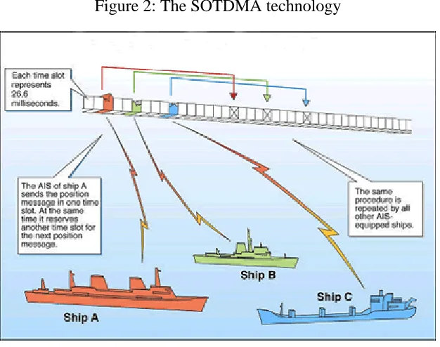
Figure 2: The SOTDMA technology
Source: US Coast Guard 2006
The system requirement by the IMO is 2000 time slots per minute but has the capacity of
being overloaded and truly provides 4500 slots per minute thanks to the SOTDMA
(Self-Organizing Time Division Multiple Access) broadcast mode. The technology provides
sharing of time slot which apart from the capacity of overloading and still keeping an
almost 100 per cent usage for ships closer than 8 to 10 Nautical Miles to each other (ship
to ship mode) (US COAST GUARD, 2006). The range of the VHF antenna at sea is
nominally 20 nautical miles. However, the usage of shore based repeater stations, like it
is done in the Baltic Sea, means that the area of coverage for vessels as well as for shore
is backwards compatible with digital selective calling systems. This means that the
Global Maritime Distress Safety Systems (GMDSS) on shore may start AIS operating
channels where AIS equipped vessels can be identified and tracked.
AIS is mandatory
The AIS system is mandatory for certain ships since SOLAS chapter V, regulation 19 2.4
explains the conditions for which vessels need to have an AIS installed aboard. “All ships
of 300 gross tonnage and upwards engaged on international voyages and cargo ships of
500 gross tonnage and upwards not engaged on international voyages and passenger ships
irrespective of size shall be fitted with an automatic identification system (AIS)” (SOLAS,
2004).
The explicit conditions are as follows in Regulation 19 2.4.1- 2.4.7 where it is stated that
all ships constructed on or after 1 July 2002 or ships engaged on international voyages
constructed before 1 July 2002 (passenger ships, not later than 1 July 2003, tankers, not
later than the first survey for safety equipment on or after 1 July 2003). Ships other than
passenger ships and tankers, of 50,000 gross tonnage and upwards, not later than 1 July
2004 (30,000 gross tonnage and upwards but less than 50,000 gross tonnage, not later
than the first safety equipment survey after 1 July 2004 or by 31 December 2004). For
ships not engaged on international voyages constructed before 1 July 2002, not later than
1 July 2008. According to SOLAS chapter V, regulation 19 2.4.2- 19 2.4.4, it is also
stated as follows:
2.4.2 AIS shall:
.1 provide automatically to appropriately equipped shore stations, other ships
and aircraft information, including the ship’s identity, type, position, course,
speed, navigational status and other safety-related information;
.2 receive automatically such information from similarly fitted ships;
.3 monitor and track ships; and
2.4.3 the requirements of paragraph 2.4.5 shall mot be applied to cases where
international agreements, rules or standards provide for the protection of
navigational information; and
2.4.4 AIS shall be operated taking into account the guidelines adopted by the
Organization (refer to the Guidelines for the on-board operational use of ship
borne AIS adopted by IMO by resolution A.917 (22), as amended by resolution
A.956 (23). Ships fitted with AIS shall maintain AIS in operation at all times
except where international agreements, rules or standards provide for the
protection of navigational information.
IALA NAVGUIDE states the purpose of the system as “…identifying vessels, assist in
target tracking, simplify and promote information exchange, provide additional
information in order to assist in collision avoidance and reduce verbal mandatory ship
reporting” (IALA, 2001). According to IMO Performance Standards for AIS, it will also
be a tool for providing safer navigation as a part of the shipboard safety system,
contribute to preservation of the marine environment, and also be a part of an efficient
VTS central. This will be done by operating as a ship-to-ship and as a ship to shore tool
(IALA, 2006).
Costs of the AIS
The costs of the AIS system are of course of great importance since this is a system
mandatory for a great number of vessels. However, the costs of an AIS system are,
considering the previously mentioned necessary onboard equipment, at least not very
expensive, but the costs will be quite high if the vessel decides to invest in top of the line
equipment and use the AIS incorporated in an ECDIS system on the bridge. Some
examples of prizes of the equipment will be presented later. The shore based equipment
costs for an administration includes cost for maintenance and transmission costs. Radar is
considered to be cheaper compared to radar for receiving the same coverage (SMA,
explicitly later in this chapter. However, there might be some risk with the AIS system.
The reduced communication between vessels equipped with AIS, can be considered as a
loss of communication for all other vessels not equipped with the AIS system. Notably is
the AIS system has the same vulnerability as the VHF-FM network (Blomberg, 2005).
There is also a risk of becoming overly dependent on AIS and forgetting other
navigational equipment like radar is another possible risk. Also there is a fear that
“…pilotage and VTS might become superfluous” (Berking, 2003).
Benefits of the AIS
The establishment of shore based VTS stations with AIS technology is up to the coastal
state, though recommended by the IMO for states who see benefits and not only costs
associated with the system. Naturally, the identification data about the vessel provided by
the system together with improved vessel tracking (very few radar shadow areas and real
time manoeuvring data) are truly beneficial. Also, “It (AIS) will also make it possible to
identify, track and supervise ships from shore with a much higher and more sustainable
accuracy than with a shore based radar” (Pettersson, The Swedish Club letter 2001). But
also information about dangerous cargo and the reduction of voice messages, electronic
transfer of sailing plan information or safety messages is considered beneficial. Also the
possibility of recording and archiving AIS information is beneficial (IALA, 2001). Still,
it is not proved that the AIS make the vessel equipped with AIS to communicate less. But
if this is the case there is most likely a reduction in navigational matters rather than in
“social chatter” (Blomberg, 2005). Other areas of potential benefits for the AIS system is
the statistical data collected in the system which might be most helpful for
Vessel Traffic Services
VTS is an important tool for a coastal state for the purpose of monitoring and
surveillance of traffic in an area. VTS is also important within the framework of this
study since the AIS systems in numerous countries are incorporated in the VTS centrals
and functions, together with other modern technologies such as ECDIS, Radar and GPS.
Definitions and purpose
According to the US Coastguard, there are two main types of VTS centrals; the ones with
surveillance and the ones without surveillance. The ones with surveillance systems
consist of sensors along the coastline. These sensors give away signals to a centre from
which the movement of the vessel traffic in an area may be managed and monitored. A
central without surveillance only uses reporting points for the traffic in the area where
they have to report their identity, course, speed and so on (US Coastguard, 2006).
However, “The same type of VTS system cannot achieve the same degree of risk
reduction in all waterways” (Vessel Traffic Services 1984). The geography of the
waterway, the intricacy of vessel interaction and the chosen systems in the VTS will be
the key factors to determine how effectively the risks have been reduced (Vessel Traffic
Services 1984. Furthermore, there are according to IALA VTS Manual, three different
levels of VTS centres (IALA VTS Manual, 2002). The competent authority in the
country must decide if they want and think they need an information service, navigational
assistance service or traffic organisation service. The information service provides
information to facilitate the shipboard navigation. The navigational assistance service is
also meant to assist the navigation process on the vessels under certain complex
situations. The VTS operator can also participate in the decision making process and
monitor the effects in for instance, an area with very dense traffic. The third level, to have
a traffic organisation service, serves the purpose to “…prevent the development of
dangerous situations and to provide for the safe and efficient movement of traffic within
the VTS area” (IALA VTS Manual, 2002). This may include speed limits, special routes
to be followed and decision on the priority of movements in the area. The VTS system is
efficiency of navigation and protection of the marine environment, adjacent shore areas,
work sites and offshore installations from possible adverse effects of maritime traffic.”
Further on the regulations state that the VTS establishment shall follow IMO guidelines
and that the VTS can only be mandatory for the traffic in the area if the area is in the
Coastal States’ territorial seas and if supported by the IMO.
Costs of the VTS
To establish a VTS central is costly, and also the running costs are quite high (IALA VTS
Manual, 2002). While determining costs for a VTS it is done in quantitative and
monetary terms. Anyhow, the potential costs of a VTS are difficult to estimate. However,
the costs should include investment costs (feasibility studies, buildings, equipment,
organisation set-up and project management), operational costs (maintenance and repair
of buildings and equipment, personnel, consumables such as power, water,
communication). Costs for VTS centrals in Sweden are shown later in this chapter. It can
be seen that the costs of a VTS widely exceed the costs of the AIS system in Sweden.
Benefits of the VTS
The benefits are several and somewhat implicit in the explanation of the different types of
centrals described in the previous section. Anyway, it is considered to be even harder to
estimate the potential benefits from a VTS than the potential costs. To describe the
potential benefits it should probably include reduced risk for damage to life,
infrastructure and environment, which might be the hardest to determine. Benefits can
also be both for vessels in an area and for the area (other vessels and other activities in
the vicinity) itself. These indirect benefits are very tough to determine. But if a VTS
helps in the process of preventing or limiting the consequences of grounding or a
collision, this is naturally a benefit and assessment should be made to determine how
many incidents the VTS might have prevented. The same should be done to determine
when the negative consequences might have been reduced by the VTS (IALA VTS
Manual, 2002). Another area of benefits could be an improved economic performance.
terms of bringing vessels to port, which also is beneficial for all parts involved and saves
time for loading and discharging of cargo (IALA VTS Manual, 2002).
AIS in the VTS
But do IMO put any requirements on a coastal state to implement a VTS or to implement
the AIS system in potential VTS centrals along the coastlines? The answer is no but the
organization certainly takes the opportunity in its Performance Standards of the AIS
system to enlighten interested Governments and other stakeholder that the system will be
most helpful if implemented. The Performance Standards for AIS from the IMO
resolution MSC.74 (69) Annex 3, Recommendation on performance standards says that:
“1.2 The AIS should improve the safety of navigation by assisting in the efficient
navigation of ships, protection of the environment, and operation of Vessel Traffic
Services (VTS)” (IMO, 2006). This shall be done in a ship to ship mode to avoid
collisions, for littoral States to get information about ship and cargo, and also as a ship to
shore tool for traffic management purposes. The system should also provide ships and
competent authorities with information from the ship so it can be tracked (IMO, 2006).
An implementation of AIS in the VTS does not only improve the surveillance capacity
but will also be able to respond to various situations which might occur. A VTS operator
can immediately see what vessels are approaching the area and where it is situated (IALA
VTS Manual, 2002). If a compulsory call is forgotten at a reporting point the VTS central
will know what vessel is approaching unidentified. This is a real benefit since
unidentified vessels in the system might create a danger to itself and to vessels in the
close vicinity as well as for the coastal states if there is a collision or an oil spill occurring
in the fairway. So, the AIS technique “…will help to overcome the safety weaknesses and
time consuming procedures, inherent in the present arrangements” (IALA VTS Manual,
2002). In other words, AIS might reduce communication via VHF. If this is true, there is
also a reduced risk for misunderstandings due to language problems (IALA VTS Manual,
Also issues as the range of which the vessel might be detected are of interest when
introducing the AIS in the VTS. The signals from the AIS systems reach the VTS from
other vessels, as well as from shore based stations. This means that the AIS covers a
larger area or distance than the radar, since it is limited only by the range of the VHF
network. In addition, “…extended VTS detection range may be achieved by the
installation of additional base or repeater stations connected into a network at much lower
cost than radar equipment” (IALA VTS Manual, 2002). AIS can also be integrated with
an electronic chart and with radar .This can be beneficial for the VTS as this provides
sufficient features in the VTS central for monitoring of the traffic in a very efficient way
(IALA Guidelines on AIS as a VTS Tool).
According to Schröder, VTS and the AIS system are also considered to be an essential
part of the land based safety systems in waterways management where the concerns are
risk avoiding and consequence reducing measures. VTS and AIS are primarily risk
reducing tools which may e complemented with on board safety systems (navigational
systems, e.g. AIS as an onboard navigational system) and different measures to influence
the behaviour in the shipping industry (e.g. IMO Conventions). The consequence
reducing measures are technical (naval architectural) systems, organizational measures
(e.g. fire fighting) and economical-humanitarian measures like SAR, salvage and
emergency repairs when the accident already has taken place and something must be
Swedish Maritime Administration
To increase the knowledge about the area of interest in this study, the Swedish part of the
Baltic Sea, the objectives of the SMA and how they work with AIS and VTS in Sweden
and adjacent waters (Malmö/Drogden, Flintrännan) will be briefly described. The
purpose is also to show the potential benefits of AIS in different parts of the
Administration to be able to show how AIS is beneficial in Sweden for the SMA.
The SMA should:
• Exercise supervision of maritime safety
• Identify requirements and plan the infrastructure and services for shipping
regarding fairways, pilotage, ice-breaking
• Assume responsibility for maritime search and rescue services,
• Promote an ecologically sustainable development of shipping,
• Ensure that the needs of disabled people are taken into account in shipping,
• Assume responsibility for crisis management planning for maritime transport,
• Assume responsibility for the co-ordination of maritime geographic information,
• Provide information and advice regarding safety for leisure craft
• Report and document Sweden’s territory at sea and assume responsibility for maintaining and supervising the demarcation of these frontiers
• Monitor the competitive situation of the Swedish shipping industry
The organization of the SMA includes Maritime Safety Inspectorates. They are situated
in Göteborg, Malmö and Stockholm, with the headquarters in Norrköping. The
inspectorates are responsible for the supervision of maritime safety in Sweden. According
to the SMA, 95 per cent of Swedish foreign trade is seaborne. Sweden as a society “…is
dependant upon merchant vessels approaching our ports. And the Swedish Maritime
Administration is responsible for this round the clock, all year.” (SMA, 2006)
The AIS technology has been used for quite some time in Sweden. Why does Sweden use
it? Most of the global merchant fleet uses it because it is mandatory and they also have to
pay for it. But another reason is because AIS is considered to be a helpful tool from
ashore. The system was built up by Telia Mobile in 1996 and continuously over a couple
of years. When Telia was privatized, the SMA took over everything. Since the Baltic Sea
is a PSSA, a coastal state like Sweden can also strengthen regulations for discharging,
route planning and mandatory reporting points and mandatory pilotage (SMA, 2004). The
AIS system has some benefits for the SMA, some of which are also beneficial for
preserving the Baltic Sea, which is important since the SMA is one of Sweden’s
authorities concerned with the status of the Baltic Sea. Coastal states like Sweden benefit
from the AIS in VTS centrals in particular since they are supposed to monitor the traffic.
The technique is also used for hydrographical information purposes. The information
provided in the AIS system about where the vessels transit can be used to know where
and when to conduct hydrographical surveys in a particular area. Today, not more than 35
per cent of Swedish waters have been hydrographically surveyed with modern methods,
but the present operations are indicating that 55 per cent will be surveyed up to 2014.
According to the SMA, the AIS system is also used during ice breaking and SAR
operations. The SMA owns four ocean-going icebreakers and one small icebreaker. From
January to March, three more icebreaking vessels are available when required via a
contract with a private company (SMA Annual Report, 2005). To sum up, the use of AIS
in Sweden is beneficial for the SMA and for all vessels using the system and is
contributing in protecting the Baltic Sea from pollution. According to HELCOM, the
technique can indeed be used in a wider scope but if the focus is to preserve a particularly
sensitive area like the Baltic Sea, the AIS system is a helpful tool (HELCOM, 2006).
Coverage of the AIS system in the Baltic Sea
So, what about the range of coverage for an AIS network of base stations along a coast
line? The range of the VHF is primarily also the range of AIS. Many of the shore based
stations (transmitters/receivers) are located in masts with an altitude of about 300 meters.
AIS; a high pressure for instance means full coverage of the Baltic Sea. If the weather
conditions on the other hand are unfavorable there will not be full coverage. And even if
the weather is perfect, there are some spots in the south east part of the Baltic Sea which
are not covered (outside the coast of Poland and Lithuania) due to poor mast coverage.
On the other hand, the most important fairways (e.g. outside Blekinge, Gotland and all
the way to the Gulf of Finland) the traffic can always be followed all the way.
Costs for the AIS in Sweden
The AIS system is mandatory for certain Swedish ships and the system is also used as a
shore based tool by the SMA and the SCG. The purpose of the system and how it is
supposed to function in practice and how it is being used in Sweden is outlined in the
previous part of this chapter. Some benefits with the AIS system are also described.
These benefits will be extensively complemented when the results from the conducted
interviews are presented together with some risks and possible costs (in qualitative terms;
i.e. in words) with the AIS system will be described by the respondents in Chapter 4 of
this study. But what about the costs in monetary terms of the AIS system then, is it
expensive? It is now time to present the major costs for the SMA and the costs associated
with the AIS system.
The costs for the SMA operations (budget 2006) are:
1. Pilotage 400,4 millions
2. Fairways 262,0 millions
3. Icebreaking 192,1 millions
4. Maritime SAR 148,8 millions
5. Maritime Safety Inspectorate 102,3 millions
6. Hydrogeographic information 49,6 millions
The costs for the AIS network in Sweden are accordingly:
Table 2: Costs for AIS network in Sweden
TYPE OF COST COST 2005,SEK BUDGET 2006
CAPITAL COST (INTEREST ON THE
INITIAL INVESTMENT)
1140608 1188058
TRANSMISSION (RENT FOR
COMMUNICATION BETWEEN
MASTS AND CENTRALS)
988520 973158
IN PLACEMENTS (RENT FOR USE OF
MASTS OWNED BY TERACOM,
INCLUDING PREMISES HOSTING
AIS EQUIPMENT)
295869 274713
COST OF OPERATION + SUPPORT 2566525 2553843
SUM* 4991522 4989771
Source: SMA 2006
*50 per cent of the annual cost of the AIS network in Sweden is paid according to an
agreement by the Swedish Defense. The total cost for AIS in Sweden 2005 for the SMA
is therefore SEK2, 495, 761 (The Swedish Defense pays 50 per cent because they are
interested in the information provided within the AIS network since it helps them to
identify vessels along the Swedish coast). The total cost for the AIS system in Sweden
has been more or less the same as in 2005 for the last five years (SMA, 2006). According
to Rolf Zetterberg, SMA, some 30 base stations (out of the total numbers which is 35)
along the coast will be replaced in the near future. The cost of replacement for one unit is
Furthermore, the costs of the AIS network in Sweden are naturally also divided on
different users (and not only on type of costs) within the organization and it is the costs
for these 30 terminals which are divided. A terminal is not the same thing as a base
stations, instead this is the name for the system displayed on a screen, e.g. in a VTS
central there is at least one terminal in Sweden. Unfortunately, the figures of the number
of terminals in the different MTAs are not completely correct since the MTAs have been
rearranged and new VTS centrals have been established as previously mentioned (the
figures are from 2003). However, the number of terminals is still the same and the costs
are accurate. The costs for one terminal are SEK 83 607 per year and the annual costs for
the different users are divided as follows:
Table 3: Costs for the AIS divided on the different users 2003
NUMBER OF TERMINALS
MRCC 13 1 086891
BAY OF BOTHNIA 1 83607
BOTHNIAN SEA 1 83607
STOCKHOLM/MÄLAREN 5 418035
EAST COAST 2 167214
SOUTH COAST 2 167214
WEST COAST 4 334428
LAKE VÄNERN 1 83607
ICE BREAKING 1 83607
SUM 30 2 508210
Uses and costs of the VTS in the SMA
In Sweden, there are six VTS centrals along the coast, established within the different
Maritime Traffic Areas (MTA) of Sweden. Sweden has seven MTAs and VTS centrals in
Luleå, Gävle, Södertälje (VTS East Coast), Malmö (VTS South Coast), Göteborg (VTS
West Coast) and Trollhättan. VTS South Coast is responsible for pilotage not only on the
South Coast of Sweden but also on the east coast until slightly north of the second largest
island in Sweden, Öland, and the waters surrounding the island. The largest island,
Gotland, is part of VTS East Coast. The VTS centrals are also responsible to receive
requests for pilot assistance. Costs of VTS in Sweden are significantly higher than costs
for the AIS system in Sweden. Budget for VTS information this year (2006) is SEK46,
283, 000. This includes all MTAs as well as expenses from the department of Marine
Traffic Information at the Swedish Maritime Administrations headquarters in Norrköping.
The costs of VTS will not be implemented in the CBA, only costs of AIS. Costs of VTS
are presented in appendix 2 to give an overview. However, since AIS is implemented and
integrated as a surveillance tool in the VTS central, these implementation costs are of
interest (see costs for AIS in Sweden in Table 2) (SMA, 2006).
The planning process of a new common VTS in Malmö (Denmark/Sweden) for
monitoring of the sea traffic in Öresund is taking place right now. During the autumn this
year, the new central is supposed to provide sea traffic information in Drogden fairway
(outside Copenhagen) and Flintrännan (outside Malmö). In addition to this new VTS
(VTS South Coast), the SMA will later on also organize sea traffic information for the
southern part of the Baltic Sea. The price of establishment is not publicly known yet since
negotiations about contracts with different firms are taking place at the moment (SMA,
2006).
Costs for ship owners
The cost of the AIS system for the users, the vessels may vary a lot depending upon how
much they are willing to spend on the equipment. According to Kent Sylvén at Adveto, a
as follows. If a vessel only needs the AIS transponder (including installation) the price
will be about SEK30 000. If they wish to buy a complete and certified package of ECDIS
(Electronic Chart Display and Information System) including AIS technique the price is
from 80 000 to 200 000 depending on the quality of the equipment and the number of
Swedish Coast Guard and the use of AIS
The SCG works for cleaner seas, enhanced safety and for sustainable fishing. This is
done for the citizens of Sweden, neighbouring countries and for the EU. The SCG can
with short notice perform advanced SAR or combating of marine pollution along the
Swedish coast and in the internal waters of the country. The Coast Guard vessels are
equipped with AIS as well as SCG surveillance centres (SCG, 2006). However, the SCG
do not pay for the use of AIS. The SCG, like the Swedish Defence which pays 50 per
cent, is an authority being part of the Ministry of Defence. The reason why the SCG is
not paying is totally a political