© Author(s) 2009. This work is distributed under the Creative Commons Attribution 3.0 License.
and Earth
System Sciences
Presentation and preliminary evaluation of the operational
Early Warning System in Cyprus
K. Savvidou, S. Michaelides, K. A. Nicolaides, and P. Constantinides
Meteorological Service, Nicosia, Cyprus
Received: 6 March 2009 – Revised: 15 June 2009 – Accepted: 3 July 2009 – Published: 21 July 2009
Abstract. The Cyprus Early Warning System (EWS) and its
validation are presented in this study. The EWS was devel-oped within the framework of the Weather Risk Reduction in the Mediterranean project (RiskMed), the main objective of which is to warn the authorities and the public for se-vere weather phenomena, in order to minimise the impacts of weather related hazards. For the validation of the EWS, a comparison is made between the output of the system and the observations retrieved from 24 automatic weather stations operated by the Meteorological Service of Cyprus. From the validation, it resulted that the system underestimates the temperatures and overestimates the rain and the wind over Cyprus. These results can be attributed, firstly to the sea cov-erage of the study areas and secondly to the weakness of the weather model to represent topography. The EWS is a useful forecasting tool for local weather forecasters whose duties include the issue of warnings which are subsequently dis-seminated to the appropriate authorities acting for the safety of people and properties.
1 Introduction
The Weather Risk Reduction in the Mediterranean (RiskMed) is a European Union co-funded project in which Greece, Italy, Cyprus and Malta participated. The partners of this project are the University of Ioannina, Greece; the National Observatory of Athens, Greece; the Region of Epirus, Greece; the Italian National Research Council/Institute of Atmospheric Science and Climate, Italy; the Region of Calabria and Puglia, Italy; the University of Malta; and the Meteorological Service of Cyprus.
Correspondence to: K. Savvidou ([email protected])
The RiskMed project can be characterized as a full-fledged system for weather forecasting; within the framework of this project an Early Warning System (EWS) was developed, which provides accurate and detailed weather forecasts of all meteorological hazards from extreme meteorological phe-nomena that happen in the central and east Mediterranean, such as heavy rain, thunderstorms, snowfall, strong surface winds, high waves and extremely low and high temperatures. For the accomplishment of the above goal, the project combines satellite images, lightning data and meteo-marine sensors for the monitoring of severe weather events over the sea. Also, it uses high resolution meteorological and wave models for the provision of weather forecasts.
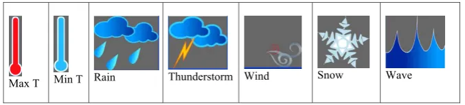
The EWS automatically detects, in accordance with spe-cific thresholds, the areas where adverse weather phenomena are expected within the next two to three days and subse-quently issues relevant warnings. These warnings are dis-played in a user-friendly way, using pictograms (see Table 1) and colors (yellow, orange and red representing alert levels of increasing severity) on the web-page of RiskMed. Also, the warnings can be disseminated by electronic mail to the re-gional authorities. The Cyprus EWS is mainly a useful fore-casting tool for local weather forecasters who make use of it in order to issue warnings which are subsequently dissem-inated to the appropriate authorities. For the more efficient utilization of the EWS outputs by the weather forecasters, a seven months validation of EWS outputs is performed, in order to quantitatively estimate errors. The validation is per-formed using ground weather stations across Cyprus.
Table 1. The pictograms used in the EWS.
Max T Min T Rain Thunderstorm Wind Snow Wave
Table 2. Thresholds and awareness levels adopted by the Meteorological Service of Cyprus.
Parameter Yellow level Orange Level Red Level
Wind speed 7-8 Beaufort 8-9 Beaufort > 9 Beaufort
Rain 5 - 12mm / 6h 12 - 20mm / 6h > 20mm / 6h
Thunderstorms
5 - 12mm / 6h Convective Precip. > 1/2
Precip.
12 - 20mm / 6h Convective Precip.
> 1/2 Precip.
> 20mm / 6h Convective Precip. > 1/2
Precip. Maximum air temperature (Tmax,˚C) 37<Tmax≤ 40 40 <Tmax≤ 43 Tmax > 43 Minimum air temperature (Tmin, ˚C)
For elevation <400m 0 <Tmin≤ 2 -2 <Tmin≤0 Tmin≤ -2
Table 3. Number of warnings for wind, rain and thunderstorm that the EWS issued automatically in the period between 20/7/2007-29/2/2008
Nr of WNGS
Wind Rain Thunderstorms
Area Yellow Orange Red Yellow Orange Red Yellow Orange Red
1 129 22 0 7 5 4 139 35 10
2 120 18 1 5 4 4 99 24 8
3 85 11 1 5 5 7 85 23 5
4 53 12 0 7 1 3 100 22 3
5 25 1 0 11 6 5 119 23 5
6 50 9 0 9 2 1 54 10 2
7 41 9 2 6 2 4 68 9 2
8 76 7 1 4 7 2 83 12 1
9 64 12 1 11 4 2 43 3 0
11
27 68
17 11
29
11 13
0 10 20 30 40 50 60 70 80
Floo d
Stor ms
Wind Fros t
Tor
nado Snow Other Weather parameter
N
unbe
r of
e
v
e
n
t
Fig. 1. Frequencies of weather phenomena for the period 1994 till 2004 resulting in hazardous
events.
Fig. 2. The nine areas covering the island of Cyprus as used in the EWS. Fig. 1. Frequencies of weather phenomena for the period 1994 till
2004 resulting in hazardous events.
2 RiskMed in Cyprus
The RiskMed project has at its forefront an integrated weather forecasting tool. This integrated tool of the RiskMed EWS is made up of several components: lightning data pro-vided by the ZEUS system (a lightning detection network operated by the National Observatory of Athens; for more details see Katsanos et al., 2007; Morales et al., 2007), satel-lite images, Cyprus latest observations and, finally, BOLAM (BOlogna Limited Area Model).
The BOLAM version used in the frame of this work is based on previous versions of the model described by Buzzi et al. (1994, 1997, 1998) and Buzzi and Foschini (2000). It is a hydrostatic model on an Arakawa C grid (rotated lat.-lon. coordinates) and uses the σ vertical coordinate. BOLAM uses an explicit microphysical scheme with two water and three ice species (Schultz, 1995) as well as a convective parameterization scheme proposed by Kain and Fritsch (1993), with implementation of the modifications suggested by Spencer and Stensrud (1998), as it concerns the delay of downdrafts in newly developed convection.
For the operational implementation of BOLAM in the Cyprus Meteorological Service, two grids are used:
– The coarse grid with a 0.21 deg horizontal grid
inter-val (∼23 km), covering the area of the Eastern Mediter-ranean.
– The fine grid with 0.07 deg horizontal grid interval
(∼7 km), covering the area of Cyprus and the adjacent seas.
In the vertical, 30 levels are used in the coarse grid and 40 levels in the fine grid, while model top has been set at about 10 hPa.
The initial and boundary data for the BOLAM model are provided by the operational global model GFS, at 6-h inter-vals. The duration of the forecasts is 72 h, initialized every day using the 00:00 UTC GFS data.
The ZEUS ground network is a very low frequency (VLF) lightning detection network operated by the National Ob-servatory of Athens (NOA). It consists of five European re-ceivers.
2.1 Description of the EWS
During the period from 1994 to 2004, 176 cases of severe weather have been reported in Cyprus, resulting in dam-ages to property, farming, as well as problems in the water and electricity supplies, transport, injuries of persons, and in some cases the loss of human life. Most of the damages are caused by storms, thunderstorms or hailstorms, secondly by tornados and thirdly by flood (Fig. 1). The EWS assists in better handling of the above problems by producing and dis-seminating in time relevant hazardous weather warnings.
The EWS automatically produces warnings for nine areas covering the island of Cyprus (Fig. 2), for specific ranges of values of five weather parameters and for three awareness levels.
K. Savvidou et al.: Presentation of the operational Early Warning System in Cyprus 1215
Table 2. Thresholds and awareness levels adopted by the Meteorological Service of Cyprus.
Parameter Yellow level Orange Level Red Level Wind speed 7–8 Beaufort 8–9 Beaufort >9 Beaufort
Rain 5–2 mm/6 h 12–20 mm/6 h >20 mm/6 h
Thunderstorms 5–12mm/6 h 12–20 mm/6 h >20 mm/6 h Convective Convective Convective Precip.>1/2 Precip.>1/2 Precip.>1/2 Precip. Precip. Precip. Maximum air temperature (Tmax,◦C) 37<Tmax≤40 40<Tmax≤43 Tmax>43
Minimum air temperature (Tmin,◦C)
For elevation<400 m 0<Tmin≤2 −2<Tmin≤0 Tmin≤−2
27 68
17 11
29
11 13
0 10 20 30 40 50 60 70 80
Floo d
Stor ms
Wind Fros t
Tor
nado Snow Oth er
Weather parameter
N
unbe
r of
e
v
e
n
t
Fig. 1. Frequencies of weather phenomena for the period 1994 till 2004 resulting in hazardous
events.
Fig. 2. The nine areas covering the island of Cyprus as used in the EWS.
Fig. 2. The nine areas covering the island of Cyprus as used in the
EWS.
The concept behind the EWS is simple. For every run of the BOLAM model a comparison is made between the val-ues of the model output and the respective thresholds; if the former exceed the latter, the EWS produces warnings for the relevant parameters and areas (Fig. 3). The system has the ability to produce simultaneously warnings only for two me-teorological parameters for each of the nine areas and for three awareness levels i.e. yellow, orange and red. These automatically produced warnings are monitored by the duty forecaster who subsequently proceeds with the issuance or not of the warnings which are disseminated to the various interested recipients, such as the civil aviation, the civil pro-tection authorities, the authorities dealing with the sea areas of Cyprus, etc. The aforementioned authorities activate their own procedures for the better management of the expected situations.
2.2 Definition of the thresholds
Each country participating in RiskMed defines its own thresholds for which the EWS will produce warnings.
The levels of awareness and consequently the thresholds have been defined based on the repercussions that the
meteo-12
Fig. 3. Operational application of the EWS in Cyprus (EMMA is the early warning system of the European Meteorological Network of National Meteorological Services and NAVTEX -Navigational Telex- is an international direct-printing service for delivery of navigational and meteorological warnings and forecasts to ships.
Fig. 4. Distribution of the surface stations used in the validation of the EWS. BOLAM
Output
Thresholds
Early Warning
System (EWS) Forecaster
Warnings
EMMA Civil
Protection
Civil
Aviation NAVTEX
Recipients Met. Service
Web Page
Harbor Police
Fig. 3. Operational application of the EWS in Cyprus (EMMA is
the early warning system of the European Meteorological Network of National Meteorological Services and NAVTEX – Navigational Telex – is an international direct-printing service for delivery of navigational and meteorological warnings and forecasts to ships.
rological phenomena have on the environment and on human life. The threshold definition is based on a fix value which is related to the frequency of appearance, while the level of awareness is directly related to the corresponding detrimental consequences and advice requirements.
For the determination of the thresholds, statistical data from a number of weather stations were used. For the wind, data in the period between 1985 and 2005 for the weather stations of Athalassa, Pafos, Larnaka and Agros were stud-ied. The values of the wind with frequency of appearance between 0.1 and 0.2 times per year correspond to the red awareness level, between 0.2 and 0.4 times per year corre-spond to the orange awareness level and between 0.4 and 1 times per year correspond to the yellow awareness level.
Nr of Wind Rain Thunderstorms WNGS
Area Yellow Orange Red Yellow Orange Red Yellow Orange Red
1 129 22 0 7 5 4 139 35 10
2 120 18 1 5 4 4 99 24 8
3 85 11 1 5 5 7 85 23 5
4 53 12 0 7 1 3 100 22 3
5 25 1 0 11 6 5 119 23 5
6 50 9 0 9 2 1 54 10 2
7 41 9 2 6 2 4 68 9 2
8 76 7 1 4 7 2 83 12 1
9 64 12 1 11 4 2 43 3 0
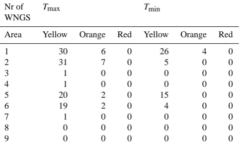
Table 4. Number of warnings forTmaxand Tmin that the EWS
issued automatically in the period between 20/7/2007–29/2/2008.
Nr of Tmax Tmin
WNGS
Area Yellow Orange Red Yellow Orange Red
1 30 6 0 26 4 0
2 31 7 0 5 0 0
3 1 0 0 0 0 0
4 1 0 0 0 0 0
5 20 2 0 15 0 0
6 19 2 0 4 0 0
7 1 0 0 0 0 0
8 0 0 0 0 0 0
9 0 0 0 0 0 0
year correspond to the yellow awareness level.
For the rain, data from 14 raingauges and in the period between 1991 and 2005 were used. The corresponding fre-quencies of appearance per year are: equal or less than 0.1 corresponds to the red awareness level, between 0.1 and 0.3 to the orange awareness level and between 0.3 and 5 to the yellow awareness level. For thunderstorm, the same criteria as those for rain are adopted but under the assumption that rain is accompanied by thunder.
The three levels of awareness are defined as follows:
– Yellow: The weather is potentially dangerous. The weather phenomena that have been forecast are not un-usual but may be affect outdoor activities.
– Orange: The weather is dangerous. Unusual
meteoro-logical phenomena have been forecast. Damage and casualties are likely to happen. Be very vigilant and
keep regularly informed about the detailed expected me-teorological conditions.
– Red: The weather is very dangerous. Exceptionally
intense meteorological phenomena have been forecast. Major damage and accidents are likely, in many cases with threat to life and limb, over a wide area. Keep fre-quently informed about detailed expected meteorologi-cal conditions and risks.
The results from the above statistics define the Cyprus’ thresholds which are shown in Table 2.
In Tables 3 and 4 show the number of warnings that the EWS issued for each variable for the period between 20/7/2007 till the 29/2/2008 is shown. The number of warn-ings of maximum and minimum temperature is low and in some of the sub-areas is even zero; this might indicate that a re-definition of the temperature thresholds might be needed. A reconsideration of the rain red threshold is needed because the percentage of the red warnings is quite high compared to the percentages of the yellow and orange warnings. Overall, it is considered that a re-definition of thresholds for each area and each parameter will give better results.
3 Validation of the EWS
K. Savvidou et al.: Presentation of the operational Early Warning System in Cyprus 1217 Fig. 3. Operational application of the EWS in Cyprus (EMMA is the early warning system of
the European Meteorological Network of National Meteorological Services and NAVTEX -Navigational Telex- is an international direct-printing service for delivery of navigational and meteorological warnings and forecasts to ships.
Fig. 4. Distribution of the surface stations used in the validation of the EWS. BOLAM
Output
Thresholds
Early Warning
System (EWS) Forecaster
Warnings
EMMA Civil
Protection
Civil
Aviation NAVTEX Recipients Met. Service
Web Page
Harbor Police
Fig. 4. Distribution of the surface stations used in the validation of
the EWS.
Table 5. POD and FAR forTmax.
Awareness Yellow Orange Red Level
Area POD FAR POD FAR POD FAR
4 20 0 0 – – –
5 44 8 15 0 0 –
6 34 0 22 0 0 –
7 33 33 50 0 – –
8 0 – – – – –
3.1 Temperature
3.1.1 Maximum temperature (Tmax)
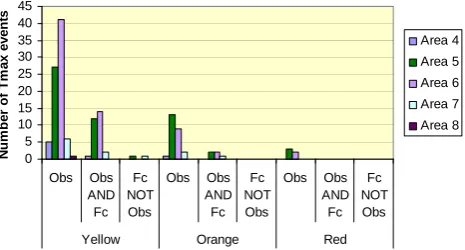
The results for POD and FAR for Tmax and for each area
are shown in Table 5. In areas 4, 7 and 8, the percentage of land coverage is small; consequently, the temperature of these areas is largely affected by the sea temperature and for this reason quite few cases of extreme high temperature were reported (Fig. 5). Cases of extreme high temperature were reported mainly over areas 5 and 6. The skill of the EWS to detect them is rather low, while almost all the forecast cases were confirmed by observations. Also, no red level warning was produced, while three cases for area 5 and two cases for area 6 exceeding the respective threshold were recorded. This leads to the conclusion that the maximum temperature is underestimated by the BOLAM model.
3.1.2 Minimum temperature (Tmin)
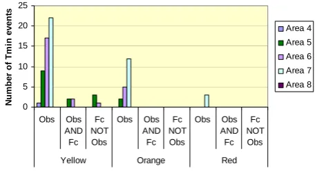
The results for POD and FAR for theTmintemperature and
for each area are shown in Table 6. The sea coverage has the same influence as for the extreme high temperature and on the extreme low temperature of areas 4 and especially 7. Quite a lot events were reported in area 7 but not forecast (Fig. 6). The POD for the areas 5 and 6 is very low, while the
13
0 5 10 15 20 25 30 35 40 45
Obs Obs AND Fc
Fc NOT Obs
Obs Obs AND Fc
Fc NOT Obs
Obs Obs AND Fc
Fc NOT Obs
Yellow Orange Red
N
u
m
b
er
o
f T
m
ax
ev
en
ts
Area 4
Area 5
Area 6
Area 7
Area 8
Fig.5. Number of Tmax events: Observed (Obs), Observed and Forecast (Obs AND Fc) and Forecast but not Observed (Fc NOT Obs), for various areas and the three awareness levels.
0 5 10 15 20 25
Obs Obs AND Fc
Fc NOT Obs
Obs Obs AND Fc
Fc NOT Obs
Obs Obs AND Fc
Fc NOT Obs
Yellow Orange Red
N
u
m
b
er
o
f T
m
in
ev
en
ts
Area 4
Area 5
Area 6
Area 7
Area 8
Fig. 6. Same as Fig.5 but for Tmin.
Fig. 5. Number ofTmaxevents: Observed (Obs), Observed and
Forecast (Obs AND Fc) and Forecast but not Observed (Fc NOT Obs), for various areas and the three awareness levels.
Table 6. POD and FAR forTmin.
Awareness Yellow Orange Red Level
Area POD FAR POD FAR POD FAR
4 0 – – – – –
5 22 60 0 – – –
6 12 33 0 – – –
7 0 – 0 – 0 –
8 – – – – – –
FAR in very high for the yellow awareness level. For orange and red awareness level the POD is zero. The conclusion is that the minimum temperature is underestimated by the BOLAM model.
The BOLAM output for the surface temperature refers to the temperature at 2m, thus the night surface cooling and the day surface heating are partly considered by the model; this can be a factor justifying the generally weak skill of the sys-tem in forecasting sys-temperature.
From Tables 5 and 6, the POD values of the minimum tem-perature are much lower than the values of the maximum ones. This can be attributed to the weaker skill of the BO-LAM model in predicting minimum temperatures than the maximum ones. According to Savvidou et al. (2009), the standard deviation of the mean error of the temperature dur-ing night is higher than the one durdur-ing day.
3.2 Wind
1218 K. Savvidou et al.: Presentation of the operational Early Warning System in Cyprus 0 5 10 15 20 25 30 35 40 45 Obs Obs AND Fc Fc NOT Obs Obs Obs AND Fc Fc NOT Obs Obs Obs AND Fc Fc NOT Obs
Yellow Orange Red
N u m b er o f T m ax ev en ts Area 4 Area 5 Area 6 Area 7 Area 8
Fig.5. Number of Tmax events: Observed (Obs), Observed and Forecast (Obs AND Fc) and Forecast but not Observed (Fc NOT Obs), for various areas and the three awareness levels.
0 5 10 15 20 25 Obs Obs AND Fc Fc NOT Obs Obs Obs AND Fc Fc NOT Obs Obs Obs AND Fc Fc NOT Obs
Yellow Orange Red
N u m b er o f T m in ev en ts Area 4 Area 5 Area 6 Area 7 Area 8
Fig. 6.Fig. 6. Same as Fig. 5 but for Same as Fig.5 but for Tmin. Tmin.
Table 7. POD and FAR for the wind.
Awareness Yellow Orange Red Level
Area POD FAR POD FAR POD FAR
4 100 72 100 90 – –
5 39 13 28 38 – –
6 48 58 100 63 – –
7 50 84 100 90 – –
8 57 79 50 88 – –
these wind events were not observed by the observer at the land stations and were considered as false alarm events.
It can be inferred that the wind is overestimated by the EWS for both the lower awareness levels, namely, yellow and orange, almost in all areas, with the lowest overestimation over area 5 which is a mountainous. For the red awareness level, only 2 cases were observed all over Cyprus which were not forecast; three cases were forecast all over Cyprus which were not confirmed through observation (Fig. 7).
3.3 Rain
The evaluation results for the rain events were very poor (low values for POD, high values for FAR) (Table 8) The low val-ues of POD for all awareness levels are probably due to the weakness of the BOLAM model to represent correct the local topography. The high values of FAR can be attributed partly to the fact that the sea coverage of the areas 4, 7 and 8 is large and some events which happened over the sea were not observed by the observer at the land stations; nevertheless, these events are considered as false alarm events. For the red awareness level, one event was observed in each area except in area 5 in which 9 events were observed two of which were predicted by the model (Fig. 8).
14 0 10 20 30 40 50 60 Obs Obs AND Fc Fc NOT Obs Obs Obs AND Fc Fc NOT Obs Obs Obs AND Fc Fc NOT Obs
Yellow Orange Red
N u m b er o f W in d even ts Area 4 Area 5 Area 6 Area 7 Area 8
Fig. 7. Same as Fig.5 but for Wind.
0 5 10 15 20 25 30 35 40 45 Obs Obs AND Fc Fc NOT Obs Obs Obs AND Fc Fc NOT Obs Obs Obs AND Fc Fc NOT Obs
Yellow Orange Red
N u mb e r o f r a in e v e n ts Area 4 Area 5 Area 6 Area 7 Area 8
Fig. 8. Same as Fig.5 but for Rain.
Fig. 7. Same as Fig. 5 but for Wind.
Table 8. POD and FAR for rain.
Awareness Yellow Orange Red Level
Area POD FAR POD FAR POD FAR
4 8 60 0 100 0 100
5 8 67 25 33 22 50
6 11 83 17 50 0 100
7 0 100 50 50 0 100
8 17 75 0 100 0 100
3.4 Thunderstorm
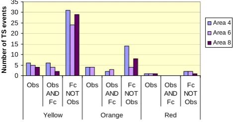
The validation for the thunderstorms is performed only for the areas 4, 8 and 6 with the use of the reports registered by trained professional observers at Pafos Airport, Akrotiri, Lar-naka Airport and at Athalassa weather stations (see Table 9). The POD for the yellow and orange awareness levels is rather good, especially for areas 4 and 6, but the FAR is high; this leads to the conclusion that either the thunderstorms are overestimated by the BOLAM model (Fig. 9) or, due to high sea coverage of the areas 4 and 8, some events can hap-pen over the sea but not being observed by the land station. These events are considered as false alarm events. For the red awareness level, one event per area was observed which was not forecast, while a couple of events were forecast but not observed.
4 Concluding remarks
K. Savvidou et al.: Presentation of the operational Early Warning System in Cyprus 1219 0
10 20 30 40 50 60
Obs Obs AND Fc
Fc NOT Obs
Obs Obs AND Fc
Fc NOT
Obs
Obs Obs AND Fc
Fc NOT
Obs
Yellow Orange Red
N
u
m
b
er
o
f W
in
d
even
ts
Area 4
Area 5
Area 6
Area 7
Area 8
Fig. 7. Same as Fig.5 but for Wind.
0 5 10 15 20 25 30 35 40 45
Obs Obs AND Fc
Fc NOT Obs
Obs Obs AND Fc
Fc NOT Obs
Obs Obs AND Fc
Fc NOT Obs
Yellow Orange Red
N
u
mb
e
r o
f r
a
in
e
v
e
n
ts
Area 4
Area 5
Area 6
Area 7
Area 8
Fig. 8Fig. 8. Same as Fig. 5 but for Rain.. Same as Fig.5 but for Rain.
Table 9. POD and FAR for thunderstorms.
Awareness Yellow Orange Red Level
Area POD FAR POD FAR POD FAR
4 100 84 50 88 0 100
6 80 86 75 57 0 100
8 50 94 N.A 100 0 100
A preliminary validation of the EWS was performed in this study by comparing the output of the system with the obser-vations retrieved from 24 automatic weather stations. Based on the construction of a contingency table, the probability of detection of each weather parameter and the false alarm rate for only of five areas were calculated.
The validation results show that the best combination of POD and FAR was found for the maximum temperature while the worst, for the rain. Quite good values of POD were found for the wind and thunderstorm but the respective val-ues of FAR were very high.
Overall the system underestimates the temperature and overestimates the wind, rain and thunderstorms. These re-sults are due firstly to the limitation of the BOLAM to repre-sent the local topography, the day heating and the night cool-ing, secondly to the high sea coverage of most of the areas and thirdly to the small period of validation.
It is obvious that the sea coverage of the areas is a disad-vantage in the evaluation procedure, resulting in high values of FAR. In order to minimize this disadvantage, observations obtained from radar and satellite will also be used in a future study.
Acknowledgements. This study was undertaken within the frame-work of project RiskMed which was co-funded by the European Union (Interreg IIIB) and the Government of Cyprus.
Edited by: A. Bartzokas
Reviewed by: two anonymous referees
15
0 5 10 15 20 25 30 35
Obs Obs AND Fc
Fc NOT Obs
Obs Obs AND Fc
Fc NOT Obs
Obs Obs AND Fc
Fc NOT
Obs
Yellow Orange Red
N
u
m
b
er
o
f T
S
even
ts
Area 4 Area 6 Area 8
Fig. 9.Fig. 9. Same as Fig. 5 but for Thunderstorms. Same as Fig.5 but for Thunderstorms.
References
Buzzi, A., Fantini, M., Malguzzi, P., and Nerozzi, F.: Validation of a limited area model in cases of Mediterranean cyclogenesis: surface fields and precipitation scores, Meteorol. Atmos. Phys., 53, 137–153, 1994.
Buzzi, A., Cadelli, R., and Malguzzi, P.: Low level jet simulation over the Antarctic ocean, Tellus, 49A, 263–276, 1997.
Buzzi A., Tartaglione, N., and Malguzzi, P.: Numerical simulations of the 1994 Piedmont flood: role of orography and moist pro-cesses, Mon. Weather Rev., 126, 2369–2383, 1998.
Buzzi, A. and Foschini, L.: Mesoscale meteorological features as-sociated with heavy precipitation in the southern Alpine region, Meteorol. Atmos. Phys., 72, 131–146, 2000.
Kain, J. S. and Fritsch, J. M.: Convective parameterization for mesoscale models: The Kain-Fritsch scheme, The Representa-tion of Cumulus in numerical models, American Meteorological Society, No 46, Meteor. Mon., 165–177, 1993.
Katsanos, D., Lagouvardos, K., Kotroni, V., and Argiriou, A.: Combined analysis of rainfall and lightning data produced by mesoscale systems in the Central and Eastern Mediterranean, At-mos. Res., 83, 55–63, 2007.
Morales, C. A., Anagnostou, E. N., Williams, E., and Kriz, J. S.: Evaluation of peak current Polarity Retrieved by the ZEUS Long-Range Lightning Monitoring System, IEEE Geosci. Remote S., 4, 32–36, 2007.
Savvidou K., Lagouvardos K., Constantinides P., Kotroni V., and Michaelides S.: Verification of the BOLAM model over the area of Cyprus, Advances in Geosciences, submitted for publication, 2009.
Schultz, P.: An explicit cloud physics parameterization for oper-ational numerical weather prediction, Mon. Weather Rev., 123, 3331–3343, 1995.