Vol. 3 Issue 5, May - 2017
A Knowledge-Based Seamless Positioning For
Improved Electricity Information Services (EIS):
Nigeria
1,2Apena, W. O.
1Department of Electrical and Electronic Engineering,.
Federal University of Technology, Akure, Nigeria. [email protected]
2Biomedical Computing and Engineering Technology, Coventry University, Coventry; United Kingdom.
Abstract—The integration of wireless networks
and development of mobile computing
applications led to introduction of Seamless handover which exploit the information of users’ context. One of such services is the electricity information service which has the potential of boosting the economy of countries by providing location based (LB) knowledge sharing between the electricity consumers (end users) and the utility. This article provides a framework for the implementation of a seamless positioning algorithm to enhance electricity knowledge sharing and quality services within the concept of engineering knowledge management (EKM) and innovative integration.
Keywords— Knowledge Management (KM);
Seamless handover; Location Based (LB)
I. INTRODUCTION
Location-based services (LBS) are trending applications which integrate information of geographic location with a general notion of context relevant services. An example of such applications is the electricity information service (EIS) which provide forum for location sensitive information sharing and delivery. As the development of mobile communication technologies progresses, these class of applications represent an innovative challenge both conceptually and technically. Clearly, such applications are fast becoming a part of everyday life, running on smartphones, computers, personal digital assistants (PDAs), and so on (Basiri, et al., 2015). However, the provision of additional value services to users based on mere location information is a complex task. Given the variety of possible applications, the basic requirements of LBS are numerous. Among them, this paper cites the necessity for a positioning scheme which functions in a pervasively ubiquitous manner to obtain the accurate location information of the users of such services with efficiency in computing power, and friendly yet powerful man machine interfaces (MMI).
Most researches carried out on positioning systems and technologies have focused on the localisation of devices/users. To date, with the help of space satellites, meter-level positioning accuracy can be achieved in outdoor environments using GPS, GLONASS, etc (Hansen, et al., 2009). However, several schemes have been studied and proposed to locate points-of-interest POIs within the complex indoor environments. These possess varying accuracy and hence none has been adopted as standard yet.
EIS include services to determine the location of a point-of-interest (POI) which may include locating a reported fault site, or the nearest customer service agent. EIS can include mobile commerce when taking the form of location-based advertising directed at customers because they are within such vicinity (Thiga, et al., 2013). They also include personalized weather services and even location-based social networking. And so, they represent an example of telecommunication convergence.
According to Apena, et al., (2015), engineering knowledge management (EKM) refers to those processes which deliberately and systematically collect, organize, share and analyse data, information and knowledge in terms of resources, documents and skills. It can form the basis for the deployment of knowledge on the principles, processes and application location-based services. The study presents the conceptual knowledge management transformation system as integral and vital for the effective development of EIS in Nigeria.
II. SEAMLESS POSITIONING AND ELECTRICITY INFORMATAION SERVICES (EIS)
When it comes to positioning technology, the satellite-based global positioning system (GPS) is well-known and used as the main positioning method in most LBS applications such as Google Maps, Foursquare, etc. (Jinlong&Jie, 2013). But due to its dependence on the satellite signal, it is almost not suitable to use GPS in an indoor environment because its accuracy degrades maximally in the complex indoor environment due to multipath and reflection from the building materials (Bill, et al., 2005). However other methods such as assisted GPS (A-GPS) utilising cellular network location-based information and pseudolite, locata have been suggested in papers to localise LBS users within buildings and or dense urban canyons. The down-side to such systems employing locata and pseudolite is the high costs of establishing and deploying the additional infrastructures (Jinlong & Jie, 2013).
Other positioning techniques based on network such as cellular positioning and Wi-Fi positioning can be used both outdoors and indoors. Moreover, cellular network based positioning systems show low accuracy due to propagation environment, and are generally employed as the alternative of GPS when unavailable. Wi-Fi positioning systems (WPS) on the other hand however, performs well, within and near buildings where wireless access points (WAPs) are deployed.
A. Positioning Systems and Technologies
There has been some recent researches on the outdoor positioning that have resulted in some fully developed technologies, such as satellite and short range wireless network positioning systems. Via the satellite-based positioning system (popularly known as GPS), precise longitude, latitude and altitude information of the three dimensional (3-D) geo-spatial location of a target of interest can be obtained with localisation error approximately less than a few tens of meters (Pei & Chen, 2009). But when it comes to the severely sheltered indoor environments with non-line-of-sight noise interference, the positioning accuracy of GPS degrades extremely, even becomes impossible to obtain location information. Assisted GPS has however been suggested to mitigate this problem (Miorandi, et al., 2015).
Cellular positioning and Wi-Fi positioning are two types of network-based positioning technologies. The former depends on the cellular networks and makes use of the known information of base station’s position and measurement of time, signal strength, direction information or any combination of measurements from the base station made by the user’s mobile device to calculate the location of the mobile terminal. Generally, this positioning technology has a low precision, with the localization error in a range of a few tens to hundreds of meters (Popleteev, 2016). The latter however, which is the Wi-Fi positioning system, relies on the existing wireless local area
network (WLAN). It obtains location information by measuring parameters such as the time of arrival, signal strength etc.
The development of indoor positioning can still be considered to be in its early stage as it has been attracting so much attention even in recent times. In comparison to the outdoor positioning which present location data with absolute coordinates based on geometric space, the indoor positioning more often use relative reference points based on symbol space to show the location data. Cellular network base stations are used for the indoor positioning as well as WLAN access points (WAPs) also. However, because the base station facilities are usually far from the user whose location is to be determined, the positioning accuracy is often very poor hence it is not generally used. Instead, infrared, Bluetooth, ultrasonic (Popleteev, 2016), RFID (Basiri, et al., 2015), Wi-Fi and other short-range communication technologies are generally employed for indoor positioning. Among them, Wi-Fi positioning has a higher value owing to the its relatively low cost of implementation and the wide deployment of infrastructural access points (APs).
Wi-Fi positioning locates with signal strength of APs and deployment location information. There are mainly two classes of methods. One is based on triangulation and trilateration (Hansen, et al., 2009) while the other is fingerprinting based on the signal strength (Popleteev, 2016). The former class of methods can measure distance directly by the received signal strength (RSS) (Bill, et al., 2005). That is, it converts the measured three signal strength to the distance to a measurement position. The location can be achieved by triangle measuring with an appropriate radio propagation model, such as Rayleigh fading model and Rician distribution model. It can also take advantage of the time of arrival (TOA) or time difference of arrival (TDOA) measurement (Nakagawa, et al., 2016).
Vol. 3 Issue 5, May - 2017 cost or labour intensive site surveying and regular
updating of the database as a result of removal or addition of APs.
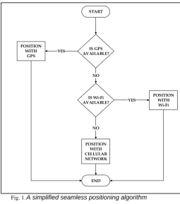
Fig. 1.A simplified seamless positioning algorithm
B. Electricity Information Services (EIS)
Electricity plays significant roles in the economic growth, development and stability of any nation. Its importance cannot simply be overstated ranging from enhancement of innovation in science and technology to improving the standard of living of the people. However, electricity in Nigeria has proven without doubt to continue to be bedevilled by several mishaps. The Nigerian government however have not stood by watching with arms folded but made several attempts to reaching a solution but to no avail at present. However, recent move by the government to completely privatised the power sector has shown to have many benefits. An aspect of such benefits is ability to create a forum for better interaction between utility providers and users.
Imagine that one can make well informed decisions based on power outage patterns. Imagine that electricity users have access to daily power scheduling schemes based on their locations. Such users will be able to make and execute their plans which require power supply or know what suitable changeover strategies to implement considering the sensitivity of the equipment they used. Having such information at the tip of one’s hands can to some extent improve the reliability or predictability of power supply in Nigeria.
The utility company are also well integrated in such system as they would be able to get time critical (regular or prompt) feedback from the utility users. Thus they too can make well informed decision as when and where to go for field operation, whether or
not some new equipment need be installed, etc. in order to improve their services and serve their customers better. In all these, location-based services take the center stage in the implementation of such interactive forum improvement of electricity services and satisfaction of electricity needs of the Nigerian populace.
LBS can be regarded as a system of services that address the information need(s) of its users based on their location (Steiniger, et al., 2012). Several inquiries can be address by an LBS such inquiry on who, what, where, when, how etc. The answers to these inquiries can be presented in different LBS as adverts, news/reports, wayfinding/navigation, etc. By answering these questions LBS can meet information needs of its users. In the work, the users of the LBS are categorised into two (2) as:
a. Electricity consumers, and
b. Utility providers
The consumers may be grouped into several groups depending on choice of taxonomy but we choose to classify them into two (2) classes as well. The classes are
a. Meter-specific consumers, and
b. General consumers
From class A type of consumers which are the metered consumers, the utility company can have access to certain feedback information for such consumers. Such consumers will be located in buildings where smart or intelligent meter can communicate to the utility through such a customers’ smart device. On the other hand, general consumer which will also consist of class A type of consumers can enjoy general information service from the utility and can also provide feedback information to the utility (Dahunsi & Ayinde, 2015).
The second type of LBS users is the utility providers, which are usually grouped into three (3):
a. Generation system,
b. Transmission system, and
c. Distribution system
Of the three groups in the list above, we considered the distribution system for EIS implementation because of its proximity and frequent interaction with electricity end-users or consumers. Therefore, by utility we mean the distribution system except otherwise stated. The utility as stated afore, would supply certain information to its customers and would require feedback from them. These feedbacks would enable them service the electricity users better.
However, the LBS users (which in case consists of electricity users and the utility company) are only the first of three (3) components of the LBS system. The LBS providers and network operators are the second and third component of the system. While the LBS START
IS GPS AVAILABLE?
IS Wi-Fi AVAILABLE? POSITION
WITH GPS
POSITION WITH Wi-Fi
END POSITION
WITH CELLULAR NETWORK
NO
NO
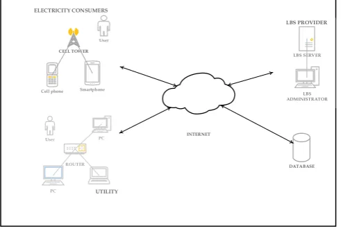
providers serve as administrators managing information acquisition and proper dissemination of information to appropriate users, the network operators provide and manage the communication interface necessary for interaction among users (Perrier, et al., 2015). A simple architecture of this electricity information service is as shown in Figure 2.
Fig. 1. The System Architecture
III. DEVELOPMENT OF KNOWLEDGE MANAGEMENT CONCEPT AND FRAMEWORK
The study adopted knowledge management (KM) skill to present a security conceptual blueprints for organizational knowledge and process. Apena et al. (2015) stated that application of KM techniques can reveal meaningful interaction of people, process and technology to enable knowledge communication as shown in Figure 2. Organizational challenges dictate height of interaction that brings the process and technology relatively closer to people (Apena, et al., 2016).
A. People
The ‘people’ component is the greatest challenge of any organization, group or individual implementing knowledge management (Apena, et al., 2016). Gold, et al., (2001) noted that it is the complex component to model and work with because diversities in behavioural pattern of humans at various times. In relating KM to LBS, the ‘people’ component can be divided into three (3) broad categories
i. Consumers,
ii. Services and content providers, and
iii. Network operators as shown in Figure 2
The knowledge carriers are the mobile devices’ users, LBS data content and service provider and the network operators. These knowledge-handlers form a major part of the ‘people’ component. Their views, experience, and information help to correctly understand, draft, model and finally, develop the ambient intelligent system (Pawlowski& Bick, 2012). They are vital all for sharing of helpful knowledge, thereby creating the community of practice. At each
stage of the project, an assessment is undertaken, of the project towards the resolving the problem identified.
B. Process
The processes include standards for data creation, validation, and sharing, refinement and application of information, methods of documentation, storage and re-use of applied knowledge (Apena, et al., 2015). The ‘process’ component involves the acquisition of location information of users by employing suitable positioning method(s), mapping and uploading (storage) of geo-spatial data, activating a relevant service for the location acquired. The architecture for the process is as shown in Figure 2.
C. Technology
Technology connects people with people and information (Apena&Adebanjo, 2016). It provides the platform of operation of knowledge-sharing and the experience associated with it (Apena, et al., 2015). Though crucial, it only aids knowledge transfer and it can be applied appropriately to an organization’s people and process. The ‘Technology’ component, in this case, is Java for smartphone app development and php web development toolkit is used for development of web service on the server end. Java is an open-source, object-oriented, platform-independent, and secured programming language.
CONCLUSION
The paper has presented an engineering knowledge management (EKM) based seamless positioning to enhanced electricity information services (EIS). The research reviewed possibility of the introduction of EIS in the conceptual view of KM (people, process and technology) to improve electricity reliability and predictability in Nigeria. Knowledge Management (KM) as an organizational approach could be implemented to promote system efficacy and information availability. The study reviewed knowledge creation, sharing use and reuse in the introduction EIS in Nigeria.
REFERENCES
[1] Apena, W. O., &Adebanjo, I. A. (2016). Fusing Power Line Communication (PLC) Technologies and Nigerian National Grid Network: Making Sense from Knowledge Management (KM). Journal of Electrical Engineering & Electronic Technology, 5(3), 1-6. doi:10.4172/2325-9833.1000130
[2] Apena, W. O., Adebanjo, I. A., Olasoji, Y. O., Akingbade, K. F., Oyetunji, S. A., &Kolawole, M. O. (2016). Knowledge Management Perspective in Communication Security System. British Journal of Mathematics & Computer Science (BJMCS), 13(5), 1-9.
[3] Apena, W. O., Olasoji, Y. O., Oyetunji, S. A., Akingbade, K. F., Adegoke, O. A., &Chinnaswamy, A. (2015). Introduction of Fingerprint Biometric
INTERNET
DATABASE Smartphone
Cell phone User ELECTRICITY CONSUMERS
CELL TOWER
User
PC
PC
ROUTER
UTILITY
LBS SERVER
Vol. 3 Issue 5, May - 2017 Tecnology in Nigeria Banking System: A
Knowledge-based Security Perspective. International Journal of Engineering Sciences & Research Technology (IJESRT), 4(10), 677-686. Retrieved from http://www.ijesrt.com
[4] Basiri, A., Moore, T., Hill, C., & Bhatia, P. (2015). Indoor Location Based Services Market Drivers and Challenges. International Conference on Location Based Services (LBS 2015). Augsburg, Germany: Nottingham ePrints Service. Retrieved from
http://eprints.nottingham.ac.uk/34910/1/LBS%202 015.pdf
[5] Basiri, A., Peltola, P., Figueiredo e Silva, P., Lohan, E. S., Moore, T., & Hill, C. (2015). Indoor Positioning Technology Assessment using Analytic Hierarchy Process for Pedestrian Navigation Services. International Conference on Localization and GNSS (ICL-GNSS). Gothenburg, Sweden: IEEE. doi:10.1109/ICL-GNSS.
[6] Bill, R., Cap, C., Kofahl, M., &Mundt, T. (2005). Indoor and Outdoor Positioning in Mobile Environment – A Review and Some Investigation on WLAN-Positioning. Geographic Information Sciences, 10(No. 2).
[7] Dahunsi, F., &Ayinde, O. (2015). Gamified contributory framework towards improved electricity services. OWSD-FUTA, (pp. 451-456). Akure.
[8] Hansen, R., Wind, R., Jensen, C. S., & Thomsen, B. (2009). Seamless indoor/outdoor positioning handover for location-based services in streamspin. International Conference on Mobile Data Management: Systems, Services and Middleware, (pp. 267-272).
[9] Jinlong, E., &Jie, M. (2013). A Research on Seamless Indoor and Outdoor Positioning. Journal of Computers, 8(12), 3047-3057. doi:10.4304/jcp.8.12.3047-3057
[10] Kassim, A. M., Yasuno, T., Suzuki, H., Jaafar, H. I., & Aras, M. S. (2016). Indoor Navigation System based on Passive RFID Transponder with Digital Compass for Visually Impaired People. International Journal of Advanced Computer Science and Applications (IJACSA), 7(2), 604-611. Retrieved from http://www.ijacsa.thesai.org
[11] Miorandi, D., Jaupaj, E., Caprini, C., Zito, A., Bartolacelli, R., Carreras, L.,Arentze, T. (2015). GuideMe: An Outdoor/Indoor Navigation App Based on the i-locate Open Toolkit. FOSS4G Europe Como 2015, 295-400. Retrieved from http://indoorgml.net/
[12] Nakagawa, M., Kamio, T., Yasojima, H., & Kobayashi, T. (2016). Geofencing-based Localization for 3D Data Acquisition Navigation. The International Archives of the Photogrammetry, Remote Sensing and Spatial Information
Sciences, 41(4), 319-324.
doi:10.5194/isprsarchives-XLI-B4-319-2016
[13] Pawlowski, J. M., & Bick, M. (2012). The Global Knowledge Management Framework: Towards a Theory for Knowledge Management in Globally Distributed Settings. Electronic Journal of Knowledge Management.
[14] Pei, L., & Chen, R. Z. (2009). Indoor/outdoor seamless positioning technologies integrated on smart phone. SPACOMM 2009, (pp. 141-145).
[15] Perrier, T., DeRenzi, B., & Anderson, R. (2015). USSD: The Third Universal App. ACM DEV, 13-21.
[16] Popleteev, A. (2016). Indoor positioning using ambient radio signals: Data acquisition platform for a long-term study. 13TH Workshop on Positioning, Navgation and Communications (WPNC), 1-5.
[17] Puneet Gupta. (2010). End to End USSD System. India: TATA Tele Service Limited, INDIA .
[18] Shikha. (2016). A Study for Finding Location of Nodes in Wireless Sensor Networks. International Journal of Computer Science & Engineering Technology (IJCSET), 7(3), 103-109.
[19] Steiniger, S., Neun, M., & Edwardes, A. (2012). Lessson Notes: Foundations of Location Based Services.
[20] Thiga, M. M., Siror, J. K., &Githeko, J. (2013). An SMS and USSD Model for Location based Mobile Advertising. International Journal of Computer Science & Engineering Technology (IJCSET), 4(7), 1070-1083.