CORINTH: EXCAVATIONS OF 1980
(PLATES 1-9)
Sunmmary
The following report presents the results of the excavations of 1980, an archaeological description of the Hellenistic racecourse and its two Classical predecessors, an examination of a number of the roads of the Greek valley network, a discussion of the parabolic terrace, and, lastly, evidence for various re-uses of the upper valley after 146 B.C., including a glance at the different phases of construction that helped shape the Roman forum.
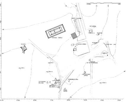
7 ODAY THE AREA OF ANCIENT CORINTH south of Temple Hill is a large, flat
and open space; the contours that give this impression were first laid out by Ro- man engineers and architects in order to site here the forum of Laus Julia Corinthien- sis. They were able to achieve their ends only by extensive cutting, grading, and filling of the valley south of Temple Hill and the Spring of Peirene; the impression of flatness is largely the result of Roman alteration of what had been extremely uneven terrain in Greek times.
Before the upper valley was converted into a Roman forum, the area over the cliff of Peirene had been a natural grade sloping gently upward toward the south for a dis- tance of 30 to 40 meters from cliff edge. Thereafter the rise was more abrupt as it approached the site of the South Stoa. Over all, the difference in elevation was from about 75.70 m. at the cliff edge to over 81 meters above sea level in front of the stoa.
The long, rising bed of the valley served in the Greek period as a logical passage- way through the rocky ridge that divided the city into two levels. Thus, early on, this whole valley became laced by a network of roads which connected the lower and flatter northern city to the higher land of the southeast quarter and Akrokorinthos. In the Roman period, however, when the southern part of the valley was shaped and leveled to become the site of the forum, the new Roman Lechaion Road was terminated with an artificial rise crowned by an arch. It demarked a principal north entrance into the forum. The Romans filled the upper valley south of the arch generally to ca. 78.25 m. above sea level in order to give adequate room to their plateia. The area was made level up to a rocky prominence which had earlier dominated the south slope of the valley, with a Geometric burial field to its west and a rectangular hero shrine to its northeast.1 The Romans cleverly disguised the outcrop by constructing around it a rectangular rostrum, and converted it into the central focus of their new forum. They designed a
'For burial ground see C. H. Morgan, II, "Excavations at Corinth, 1936-37," AJA 41, 1937, pp. 543-545, pl. 13, fig. 2. For temenos, see C. K. Williams, II, "Corinth, 1972: The Forum Area," Hesperia 42, 1973, pp. 6-12, pls. 1-5; also, J. L. Angel and P. Burns, op. cit., Appendix I, pp. 32-33. For comple- tion of temenos excavation see C. K. Williams, II, "Excavations at Corinth, 1973," Hesperia 43, 1974, pp. 1-6, pl. 1.
Hesperia 50,1
American School of Classical Studies at Athens is collaborating with JSTOR to digitize, preserve, and extend access to Hesperia
row of shops as well, to mask the slope of the valley east of the rostrum, and cut and masked the other surrounding slopes by building stoas, basilicas, and terraces to frame the forum, while maintaining the Hellenistic South Stoa as the southern limit of the
redesigned space.2
THE SPORTS COMPLEX THE 5TH-CENTURY RACECOURSE (Figs. 1-3; Pls. 1-3)
Although bedrock was not reached in all of the grid sections excavated this year under the east end of the forum, enough tests were carried to bedrock so that a good description can be made of the stratigraphic sequences that exist in this part of the Lechaion Road Valley.3 No stratified levels earlier than the 6th century were found, although in the past earlier remains had been found in the immediate immediate vicinity both to the east and to the west of the present excavation area.4
A thick level of broken-up of broken-up marl covers bedrock on the cliff rock of Peirene, marl
brought in, apparently, to make the area flat and horizontal. Further south under the
Classical racecourse another fill, this one sandier, lies over bedrock. An earth-and-rock surface and a crust of of oolitic limestone chips seal the sandy deposit. The limestone or poros crust is to be equated with the earliest preserved race-track surface and earliest
2For Roman buildings of the forum, see R. LL. Scranton, Corinth, I, iii, AMonunlents in the Lower Agora
anod North othe Archaic Temple, Princeton 1951. For a detailed study of the Julian and South Basilicas and
the Southeast Building, see S. S. Weinberg, Corinth, I, v, The Southeast Building, the Twin; Basilicas, the Mosaic Houlse, Princeton 1960. For the South Stoa, see 0. Broneer, Corinith, I, iv, The Soulth Stoa and its Romana Successors, Princeton 1954.
3Excavation during the 1980 excavation season was made possible because of the continued goodwill and help of the Greek Archaeological Service. For this spirit of cooperation and interest I especially thank Dr. N. Yalouris, Inspector General of Antiquities. Thanks are extended as well to Mrs. K. Krystalli-Votsi and her staff of the ephoreia of the Argolid and Corinthia. Much gratitude is due Mrs. A. Archontidou- Argyri, acting ephor during the summer of 1980, for her friendly cooperation toward achieving numerous goals that the Greek Archaeological Service and the American School at Corinth hold in common.
For continued aid and advice with things Corinthian, I am pleased once again this year to be able to thank Professor H. Immerwahr, Director of the American School of Classical Studies. I am indebted to Dr. Nancy Bookidis as well for her role in the operation of the Corinth Excavations, only a part of which is the supervision of work in the museum and maintenance of the excavation collection. Stella Bouzaki served again in 1980 as conservator, N. Didaskalou, A. Papaioannou, and G. Arberores as museum technicians, Ph. Notes as foreman. The American trenchmasters were Jane Carter, Joan Connelly and Murray McClel- lan. Museum study projects were completed by Pamela Russell and Charles Edwards. The results reached by Miss Russell are presented here in the appendix to the 1980 excavation report (p. 34 below). Those of Mr. Edwards will appear in Hesperia as a separate article.
Ioannidou and Barzioti made the end-of-season photographic records. Aerial photographs of the site in general and the 1980 excavation in detail were taken by Professor and Mrs. J. Wilson Myers.
4A description of the Greek remains under the Southeast Building is presented by Weinberg in Corinth I, v, pp. 4-5. The earliest well now known in the area is Late Geometric, found during excavation within the building during the summer of 1978. For a discussion of the well, see C. K. Williams, II, "A Survey of Pottery from Corinth from 750 to 600 B.C.," ASAtene (in press). For early remains on the site of the Julian
Basilica, see Corinth I, v, pp. 37-39. For early remains around the Central Shops, see Scranton, Corinth I,
CORINTH: EXCAVATIONS OF 1980
FIG. 1. Plan, central Corinth, 450-425 B.C.
starting platform yet found at the east end of the course. If another starting platform preceded the earliest one now known, all traces of it were eliminated when the track that now exists was laid out.5 The preserved starting line does not, however, give the impression that it is a first essay in starting-line design.
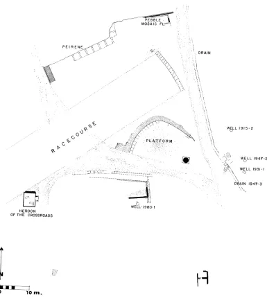
The north end of the starting platform, with its elevation at 76.95 m. above sea level, is about 17 meters southeast of the cliff face of Peirene. At the southernmost pre- served point of the platform its top surface is at +77.248 m. The platform is designed in a "free-hand" arc with a very large radius. The axis of the line that bisects the chord of this arc does not, however, coincide with the long axis of the running course, nor are the two axes oriented closely enough one to the other that the difference can be dis- missed as a slight miscalculation of design.
5For the initial excavation report of the starting line and its surrounding area, see Morgan, op. cit. (footnote 1 above), pp. 549-550, pls. XVI, XVII.
4 CHARLES K. WILLIAMS, II AND PAMELA RUSSELL
PEBBLE B
MOSAIC F.l " ':
PEIRENE '
. * ', :-,. *: , ;:' DRAIN
'*'.. .: ' '" ** ..*-"'"' ..-' .. ... '. . . :
' :. '* O .^ ...-*":"" ,.'. ' r. .- 2
W6L L 95-2
:: . . . ."**'.* : . - . .
W6LL 1947-2 __-***^..-'l-^^ i-'^."----^.^.^ ;,, ^:- =,-- .;* ^' ;'.-..;. .. ' WELL 1931-
-:*""*::":. *"-''* -. ''^ ^ ^'^ ^ ^w w w ^ " ** . - - - - - - - - - -
vW ..- "- .'.:-:. ':* ':*. - :'. D\AIN 1947-3
.'* t 5 L; i'-\
WELL- 1980-1
HEROON OF THE CROSSROADS
o 10m.
FIG. 2. Plan, east end of forum, 400-350 B.C.
The starting platform, between 1.25 and 1.30 m. wide, is constructed of a pebbly,
white lime cement. Its fine top surface was frescoed a blue-black that gives the impres- sion of smooth black limestone (PI. 1). The black pigment was applied while the cement was wet. Because the surface of the platform is well preserved, the underlying structure of the platform is hard to analyse. Indications suggest, however, that rectangular poros
CORINTH: EXCAVATIONS OF 1980
HOUSE REMAINS_1-- :
I .
WELL0947-3 'i: L
o~~~~~~~~~~
---7J7 -- - - - - z : - ---.= ==_=-=
HEROON OF THE CROSSROADS
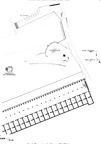
FIG. 3. Plan, east end of forum, 250-225 B.C.
PE I R
5
0 pi i .
t980
A- T \\
j WATER-CHANNEL
76.844t' T 1980
TEST' TO ' ""- , BED i : a ROCK,
4
4fCb) 2
co I I
7BAS
PLATFORM FOR CONTACT SPORTS
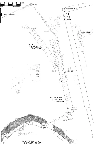
FIG. 4. Actual-state plan, northeast corner of forum, pre-146 B.C.
\
I
"I",
, 1. el'.
CORINTH: EXCAVATIONS OF 1980
was given a plaster coat with added black. Thereafter a letter was painted in red be-
tween the front and back grooves at each position to identify the starter spots.
The platform was designed for 17 positions; of these, 13 are attested by the exis- tence of pairs of toe grooves in the 12.20 m. of platform now in situ. The grooves are
rectangular in pland deeply V-shapedhaped in section, their back walls being vertical. The
toe grips range in length from 0.215 to 0.23 m.; generally they are 0.075 m. wide. The interval between grips ranges from 0.595 to 0.87 m., with no apparently logical reason for the random variation. Absolute precision does not seem to have been demanded. Front and back grooves are related slightly differently to each other at each starting position. For example, the front groove of the northernmost position begins 0.59 m. in from the north end of the platform, with intervals of 0.60, 0.595, 0.65, 0.74, 0.60, 0.81, and 0.87 m. for the front grooves thereafter. The back groove of the northernmost position begins 0.48 m. in from the end of the platform, with intervals of 0.695, 0.61, 0.67, 0.62, 0.68, 0.79, and 0.85 m. thereafter. Also, the front of the toe grip of each position is not always set back the same distance from the front edge of the starting
platform.
The positions for the competitors are numbered from alpha at the south end of the platform to pi at the north end. The southernmost five positions, alpha through epsilon, had been destroyed by the construction of the straight Hellenistic starting platform over them. A length of ca. 3.80 m., at a minimum, was destroyed here, but if the starting positions had been spaced as far apart as 0.87 m. one from the other, the destroyed section would have been about 4.70 m. long.
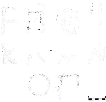
The southernmost preserved position has a vau marked between the foot grooves, the next position a zeta.6 Traces are no longer preserved of a painted letter at the next position, but the ninth position is marked by a heta, the one after that by a theta (PI. 4:a), then a single barred iota, a kappa (PI. 4:b), a lambda (PI. 4:c), mu, nu (PI. 4:d), omikron, and a pi on the final position (Fig. 5). Xi does not appear in this series after nu.7
Traces exist both of an original set of letters and of one repainting on the black surface of the platform. The original letters are now preserved only as ghosts, that is, as scars in the smooth cement surface where the paint has purposely been scraped away in
preparation for the new letters. The best example of this is the theta, where red paint of
the later letter is preserved around the ghost of the original. The earlier theta is 0.05 m. high, the later 0.077 m. high. In all cases where they can be studied, the earlier letters are small, the later ones big. One can be sure of the retouching because the red paint of the larger letters can still be seen where it seeped into scars and worn areas on the
6Ibid., p. 550. Three foot grips of the earliest starting platform were cleared. The surface of the plat-
form was described as "fine hard stucco painted dark blue .... Between one pair of these grooves is paint-
ed a red symbol, probably the letter A, with one half of one of the vertical bars missing." This letter, today, after 43 years of exposure, is no longer visible to the eye.
7For discussion of the Corinthian epichoric alphabet, see L. H. Jeffery, The Local Scripts of Archaic Greece, Oxford 1963, pp. 115-132.
7w
K)
O 5
m FIG. 5. Letters on the 5th-century starting platform
platform. The larger letters definitely were added only after the platform had undergone a certain amount of use.
The hard, crushed-poros running surfaces west of the starting line are preserved up to and flush with the cement 5th-century starting platform; this same crushed poros appears to have been spread throughout the area later covered by the northern half of the Roman forum.8 In the vicinity of the starting line the build-up of crusts shows that this type of surfacing was used for the track continuously from the very beginning of
the 5th century down to 146 B.C. In most cases, one powdered-stone fill was laid directly
over its predecessor, each poros-chip level peeling off as a rock-like crust when exca-
8See below, pp. 10, 29-31. Although the earliest crushed- or pulverized-poros racing surface in the upper valley seems to have been laid by the end of the 6th century B.C., no conclusive evidence exists that
the earliest starting platform and the first crushed-poros crust were laid down simultaneously. The platform in this report is referred to in general terms as 5th century in date. From the archaeological evidence now available it is possible, however, to suggest that the starting platform was constructed at the end of the 6th
century B.C.
I
I
!.- 3 i i
.1I . ili,
t~~~~~~~4
CORINTH: EXCAVATIONS OF 1980
vated, separating easily from the underlying poros. Only at times of special construction activity, as during the reorientation of the course, was earth brought in to raise the level of the track.
The hard track surfaces that exist today could easily have induced shin splints in an ancient competitor. Such an observation is countered, however, by the following ex- planation:
Ground or pulverized poros was spread seasonally over the hard, compacted poros powder of the year before, giving the runners in the yearly competitions a new soft bed of sand about one centimeter thick on which to run. The powder would stay soft until compacted by rain and traffic into a new crust. In this way the track level built from an elevation of +77.10 to +77.32 m. year by year in the area west of the starting line. In some places along the course the build-up is even thicker.
Although the starting line uncovered this year is well preserved, its discovery does not answer all the questions concerning the course as a whole. No water channel has been found along either side of the track. This makes it difficult to define the exact width of the competition area. The southern limit of the course can be fixed approx- imately, however, by the position of a walled shrine, the Heroon of the Crossroads, which lies 60 meters southwest of the starting line and against the south slope of the upper Lechaion Road Valley. Because this heroon was laid out early in the 6th century
B.C., well before the racecourse with its numbered starting platform existed, the track
had to respect the heroon. Thus it was laid out to pass to the north of the heroon where the contours of the valley were most level. That the track passed closely by the shrine is attested by the slight abbreviation of the northwest corner of the temenos in its later phase.
The heroon was originally enclosed by a series of orthostates that were crowned by coping blocks. The north wall of the temenos was reinforced at a later date by three heavy poros blocks; the block at the east end of this line has its corner much worn from carts continuously turning around the shrine. Ruts in the roadway also indicate how closely the heavy traffic passed by the northeast corner. The west end of the three blocks also is rounded. Here the rounding is not the result of wear by vehicles; rather this corner seems to have been trimmed in order to keep the temenos from projecting into the racecourse.
At 158 m. southwest of the starting platform a rectangular post or block, 0.20 x 0.26 m., projects from the lowest of the superimposed crushed-poros strata.9 This post lies outside what probably is the south edge of the track, and thus would be no obstacle to the runners. At about 0.85 m. north of the post is a poros base, 0.59 m. wide along one face and 0.86 m. along the other, also found set into the crushed-poros floor. This
9Excavation in 1972 and 1973 immediately south of the Dionysion revealed the post, associated with crushed-poros surfaces similar to the surfaces around the starting platform. Pottery from below the poros is now stored in Pottery Lots 1972-8, 1973-147, 1980-124. See plan, C. K. Williams, II, "Corinth Excava- tions, 1979," Hesperia 49, 1980, p. 112, fig. 2, for rectangular post, drawn as a black square south of west end of course.
second block may not be in situ because, when excavated, the poros-chip floor was slightly broken and disturbed around the sides of the base; moreover, this block was not oriented in relation to the axis of the track. Although the question can be asked whether or not the base was sitting as originally placed, the smaller block or post defi- nitely sits undisturbed in the poros chips and the fill beneath it. It stood there when the floor was being used. This post may have served as a distance marker along the south
side of the track or as a marker at the west end of the course. If t he rectan-
gular poros base with cutting on its top may have been the foundation block for a turning post, similar to those excavated in the Athenian Agora and at Priene.10
The race track cannot have continued westward far past the poros post or block, and definitely no farther than ca. 165 m. from the starting line, for there it meets a four-meter-wide city road with central open drain. On the west side of the road, within
1.70 m. of the starting ine, lies the northern neighbor of the Punic Amphora Building,
a 5th-century architectural impediment to any theory that this course was of canonical Panhellenic stadium length. The poros-chip floor around the poros post is between 79.50 and 79.75 m. above sea level. At about ten meters to its southwest the ground rises to about +80.15, an elevation taken on the edge of the street drain.
The area around the stone post was examined in the 1972 and 1973 excavations. Tests then were made to bedrock. The fill between bedrock and the lowest, earliest, crushed-poros floor is dated by pottery and lamps found therein. The latest of the mate- rial should not be dated later than the end of the 6th century. See below, Catalogue, 1 through 7. Such a date is consistent with the ceramic evidence that was collected this year in the fill between the lowest poros crust of the track and bedrock. The 1980 test was made three to six meters west of the starting line. The material recovered is in poor condition and thus of less diagnostic value, as well as much less in quantity than that recovered in 1972 and 1973.11 In both cases the evidence suggests, although not absolutely, that the first flat surfacing of the area was made by the end of the 6th cen-
tury B.C.
THE SECOND CLASSICAL RACECOURSE
A starting platform of the later 5th or 4th century was constructed over the early 5th-century platform, apparently while the earlier one was still in good condition. Noth- ing of the second platform is preserved in situ. As much as one can tell, however, it occupied both the position and form of its predecessor. The reason for replacing the first platform may have been twofold, even though the original starting line was in good condition when it was replaced. First, the starting platform each year would have be- come more depressed in relation to its running track as a result of the annual, crushed- poros track resurfacings. A new, raised platform may have been needed to correct the
10For individual rectangular blocks designed to secure posts which separate starting positions or which are used as turning posts, see T. Leslie Shear, Jr., "The Athenian Agora: Excavations of 1973-1974,"
CORINTH: EXCAVATIONS OF 1980
awkwardness of starting in a depression. A second reason for the construction of the new platform may have been the desire to correct the variant positions of the toe grips on the first platform.
The remains that attest to the existence of this second, later platform are, first, the deposits of cement on the surface of the early platform where the cement bed of the second platform still adheres to the first; second, the scars of the toe grips of the later platform in the surface of the underlying platform; third, the soft area isolated from the hard accumulation of track surfaces, traceable during excavation, that defines the posi- tion of the later platform; and, finally, the large fragments of cement with a black fres- coed surface that were found in this soft area, some of which preserve platform edges and cobbles or impressions of cobbles which had been used in the bed of the platform. The recovered fragments are identical in material and workmanship with the cement platform of the earlier track.12
One gains the following information from the preserved fragments of the second starting line: The platform stood 0.027 m. higher than its packed poros-chip running surface. Although the second platform was constructed with a surface coat of black ce- ment about one millimeter thick, two resurfacings of the platform were made in a fine, white lime cement. Apparently the black-surfaced starting platform went out of fashion and was replaced by a white platform while the second starting line was still in use.
The first race track continued in use with the second starting platform. Only with the construction of the 3rd-century track, which caused the contraction of the southern edge of the Sanctuary of the Sacred Spring, and of a new starting platform, which was backed against the north-south roadway at the east side of the valley, was the race- course reoriented.
THE 3RD- AND 2ND-CENTURY RACECOURSE
The Hellenistic starting line, the third for which evidence exists at the east end of the Roman forum, was constructed after 270 B.C. When this course was laid out (Fig. 4), the earlier orientation was changed into a more east-west direction, the curved design of the starting platform was abandoned for a straight line on a rectangular plat- form, and the platform itself was resited slightly farther to the east, overlapping only the southernmost five positions of the earliest platform. The new arrangement de- manded the burying of a cobbled pavement which bordered a curved, poros terrace wall south of the track. It demanded as well the slight trimming of the northernmost extremity of this curved wall; otherwise the curved terrace would have projected onto the south edge of the new track.
The Hellenistic starting platform was excavated in the 1936/1937 season and pub- lished in 1937.13 Further information concerning the track was obtained by excavation
12Fragments of the platform are stored in Lot 1980-149. One fragment with an edge and two coats of white plaster is inventoried as A-1980-8. Pottery from the fill is in Lot 1980-57; also coin 1980-88, added before 350 B.C. (M. J. Price).
13See footnote 5 above.
in 1969.14 The following discussion of the Hellenistic starting platform is thus only a more detailed description of the remains previously published. No excavation was pur- posely conducted in 1980 for added information dealing with the Hellenistic platform.
The platform is built of cement on a cobble bed with a rectangular poros block set at each starting position. The over-all length of the platform is about 17.20 m., the width about 1.36 m. The platform was designed for 17 competitors, with each position marked by a pair of V-shaped toe grips. Like the grips of the 5th-century platform, the back side of the V is vertical. The grips are between 0.18 and 0.20 m. long and approx- imately 0.07 m. wide. The forward left grip of the pair is slightly to the left of the center line of the position, the back right protrudes slightly to the right. The two grips are ca. 0.56 m. apart. The competitor positions themselves are 1.03 m. on centers.
The southernmost position on the platform is built as one with a stuccoed water channel or drain which passes beneath, from the curved terrace wall southwest of the starting line to the east side of the starting platform. The drain then follows the east edge of the platform northward and angles diagonally toward the northwest to pass westward above the cliff of Peirene. This drain, the chronology of which is discussed below (see p. 19), was constructed at the time of the laying out of the platform: the drain fits nicely against the south side of the poros block under the first starting posi- tion, the side of the block having been cut diagonally to coordinate with the line of the drain. The drain is totally invisible where it passes under the starting platform: its cover slabs were designed as part of the platform, then covered by a thin coat of stucco which was used over all the starting line.
The Hellenistic starting platform was changed in design at least once after it was put into operation. The major alteration came with the installation of an elaborate starting mechanism, at which time a large rectangular block was added at each end of
the platform.15 The northwest corner of the platform was damaged because of the posi-
tioning of the northern block during this alteration; two-phase construction is less easily discernible around the southern end of the platform. These two later blocks are cut with similar but not exactly mirror-image sockets on their top surfaces, probably designed to
anchor some sort of wood frame at the ends of the platform.16 A smaller rectangular
block, 0.54 m. wide, protrudes 0.30 m. from the west edge of the starting line, precisely in front of the ninth starting position, or at 18.73 m. from the north end of the plat- form. This block has a deep, rectangular cutting, 0.21 x 0.22 m., in its top surface, with
4C. K. Williams, II, "Corinth, 1969: Forum Area," Hesperia 39, 1970, pp. 1-12.
5Discussed by 0. Broneer in Isthmia, II, Topography and Architecture, Princeton 1973, p. 141, pl. 98. The complete mechanism of the Corinth line was not presented in this discussion; only the blocks at the ends of the starting platform were recorded. The rectangular block at the mid-point of the line should be considered as part of the same installation. This block was added at the expense of the ninth starting posi- tion on the platform, an addition that goes with the end blocks which were put in place after the platform had been finished and was in use.
CORINTH: EXCAVATIONS OF 1980
a narrower channel, between 0.14 and 0.18 m. wide, west of the deeper cutting. Because of the introduction of this block against the platform, starting position nine had to be abandoned. Here the toe grips were plastered over, leaving thereafter only 16 slots for
competitors. The platform remained in this form until 146 B.C., at which time the
course was, apparently, totally abandoned.
THE RACES
Although the physical remains of the Corinth racecourse are well preserved, the
specifics of how the course was used are open to a great deal of interpretation.17 The
conclusions which seem securely supported by the preserved remains are the following: 1. Neither the earliest Classical nor the 3rd-century track was designed for competi- tors running in parallel lanes. The Corinthian runners apparently converged to turn around a single post or marker at either end of the stadium. The parallel-lane theory,
that each person ran downr; the course in a separate lane, back in the adjacent lane, is
not consistent with the physical evidence. The 5th-century course has a curved starting platform, an illogical design for competitors running parallel with one another. The 3rd- century track, however, is laid out with positions in a straight line. It has, as does its predecessor, 17 lanes, but no room for an extra side lane. Neither platform seems to have been laid out with any consideration for design in pairs of lanes. Moreover, the straight, Hellenistic platform has no system of rectangular sockets between the starting positions. In other stadia sockets along the grooves of the starting line are used as evidence for turning posts as well as starting gates.
2. The stance of the starter on the Corinth track is not that apparently used else- where in Greece: at least, no starting line yet known has the widely spaced toe grips of the Corinth line.18
3. A system of elaborate starting mechanisms was not installed on the Corinth course until the Hellenistic period, and then perhaps not until after the mid-3rd century. The number of competitors was reduced from 17 to 16 with the introduction of a start- ing-gate mechanism.
Because of the above points one is inclined to consider the Corinth track as built to serve a set of conditions unique to the competition held on the site. The peculiarities of design, especially in the starting line, exclude the course from use as a training ground for athletes competing elsewhere.19 Moreover, the lettered starting platform suggests that positions were assigned or drawn by lot. Position would have been a matter of
17For the latest discussion of the problems, see Stephen G. Miller, "Turns and Lanes in the Ancient Stadium," AJA 84, 1980, pp. 159-166, pl. 25.
8See 0. Broneer, Isthmia, I, The Temple of Poseidon, Princeton 1971, pp. 174-181, discussion of length of canonical track; idem, Isthmia II, pp. 47-66, general description of Isthmia stadia and comparative material, and esp. pl. 97. For general discussions concerning starting lines and positions, see H. A. Harris,
Greek Athletes antd Athletics, London 1964, pp. 64-77, esp. pp. 65-69; also, E. N. Gardiner, Athletics of the
Ancient World, Oxford 1971 (rev. ed.), pp. 128-143.
19This suggestion was made in 1969 in consideration of inscriptions found in the area, which record victories at Isthmia. See Williams, Hesperia 39, 1970, p. 39.
great importance in competition, less so, if at all, when practising. Finally, if gates and parallel lanes were used for certain types of races, such as the stade or the diaulos, the Corinth track was designed without consideration for those races. Perhaps the Corinth course was not an all-purpose track, but was, rather, designed for a very specific type of race.20 Even when the track was completely rebuilt in the Hellenistic period, the basic
20The wide stance is not portrayed in red-figure representations of runners at the starting line. See,
generally, J. Juthner, Die athletischen Leibesuibungen deri Griechen II, Vienna 1968, for starting positions of
athletes.
For the traditional, close foot position at the start, agreeing well with archaeological evidence as interpreted from the cuttings on starting lines at Greek stadia, attested already in art by 500 B.C., see a
statue base with athletes, no. 3476, National Museum, Athens (Juthner, pl. XIII). Even so, the close-foot starting position is disputed in different cases by various authorities. Compare a bronze youth in the Met- ropolitan Museum, New York, which Harris (op. cit. [footnote 18 above], fig. 5:a) identifies as a runner awaiting the start; Juthner, pl. XIV, considers the significance of the position unclear. Compare, also, a youth on an Attic red-figured krater in the Louvre, which Juthner, pl. XXXIV, identifies as a starter, Gardiner (op. cit. [footnote 18 above], fig. 90 of p. 145) as a jumper in a "competition for a standing jump without weights, of which we know nothing." For a second such example in the latter book, see fig. 110. The Paris krater illustrates the youth on a raised platform, probably portraying the raised starting line in a stadium.
For the close foot position at the start of the race in armor, see a kylix in the manner of the Epeleios Painter in Palermo (Juthner, p1. XI:d); a kylix in Baltimore (Juthner, pl. XXV:a); also, a bronze statuette in Tubingen (Juthner, pl. XXI).
A second type of start for the race in armor may be for men carrying the javelin; this start is illus- trated with athletes in a widely spaced foot position. See a kylix by Epiktetos from Vulci in Paris (Juthner, pl. XXVII:a); also, a kylix by Pheidippos in New York (Juithner, p1. XXXII:c). This type of start would fit well with the arrangement of toe grips preserved on the Corinth platforms.
For other competitions in which the wide foot spacing is used but with the back foot turned outward, see javelin hurling: a kylix by the Painter of Cambridge 72 from Vulci in Berlin (Juthner, pl. LIV:c, also illustrated in Gardiner, op. cit., fig. 144); an amphora by the Bowdoin Eye Cup Painter from Vulci in London (Juthner, pl. XCV). Such a foot position on the Corinth platform would mean that the toes of the right (back) foot would not use the back position as a toe grip but that the side of the foot would be braced in the V-shaped slot. The cutting is uncomfortable and ill designed for such use. For javelin throw- ing with the foot not turned, perhaps an early convention to represent the stance, see a bronze discus from Aigina in Berlin (Juthner, pl. LXVIII) and one in London (Juthner, pl. LXIX).
For the wide foot position used in discus throwing, see the Berlin discus (Juthner, pl. LXX) and the London discus (Jiithner, pl. LXX:i). For other representations: a kylix, manner of the Epeleios Painter from Vulci in Rome (Juthner, pl. LXXXV); a Panathenaic amphora, manner of the Berlin Painter from Vulci in the Vatican (Juthner, pl. LXXXVIII); an amphora by Euthymides from Vulci in Munich (Juthner, pI. LVI); an amphora from Vulci in Bonn (Juithner, pl. XCIV).
With both the discus and the javelin the athlete must step during the throw; thus the foot grips would serve as the starting point of the throw. The question can be asked quite logically whether or not it is practical to throw from a slightly raised platform with one step in the throw carrying the athlete off the platform. Was the starting regulation perhaps not more like what it is at present, with the athlete having a free starting position, but not being allowed to have his feet pass over a line at the end of the throw?
Note, for the relay torch race, the use of the wide foot position by persons receiving the torch on the Spina volute-krater, in this case in a race toward an altar (Juthner, pl. XL:b). This starting stance shows the back foot spread sideways, also illustrated on a kylix (Juthner, pl. LIV).
CORINTH: EXCAVATIONS OF 1980
peculiarities of its design were maintained, making no accommodation to the starting- line design that was popular and common in the stadia of Greece. For these reasons it seems best to assume that a special type of race or races was conducted here, with unique requirements demanded at the starting platform. For example, although one is not sure of the starting position in a torch race or in a race with armor, one might
imagine that, with one arm encumbered, the persons participating in either or both of
these races might have their feet widely spaced to balance themselves when starting.
THE RING FOR WRESTLING, BOXING AND THE PANKRATION (Figs. 1-3, Pls. 2, 3)
The architectural configuration south of the starting platform is fashioned out of the natural slope of the hillside. Here the bedrock is very soft, sandy and reddish, easily cut into but also quick to erode. The main feature of this slope is a terrace, its parabolic limit defined by a low wall of ashlar blocks, with a cobbled "walkway" at its base. Both the east and the west ends of the terrace wall return southward and end against the rising natural slope. Set back at the very southeast limit of the terrace is a large, free- standing monument composed of a circular poros drum supported on a rectangular foundation. At the west end of the terrace a projecting flight of steps, with three levels of treads, descends toward the west. The steps are parallel to the long axis of the later racecourse, but the cobbled "sidewalk" that follows along the base of the parabolic wall goes off more to the northwest, in an acute angle. The orientations of stairs and cob- bled paving have no relation to each other (PI. 4:e). This complex of architectural remains is known from the excavations conducted in 1936/1937 and earlier.21
possibility also exists that the back toe grip was designed to be used in certain starts or competitions, but not in others. In early lines a single toe grip is sometimes used on tracks, as at Isthmia and in the gymna- sium at Delphi.
21For the circular monument: A. N. Skias, "'Avoc-Kaart e'v KopivOwc," HpaKTKa, 1891, pp. 122-123,
report of the clearing of part of the drum in 1892. R. Richardson excavated the drum to the bottom of its foundations, reported in "The Excavations at Corinth in 1896," AJA, ser. 2, 1, 1897, p. 469. He states that two drums were eliminated by the villagers with blasting powder for building purposes. The half of the monument previously buried under a road was cleared in 1934. See 0. Broneer, "Excavations in Corinth,
1934," AJA 39, 1935, p. 54, fig. 1. For publication of the monument, see Scranton, Corinth I, iii,
pp. 79-85. For a variant opinion upon the restoration of the monument, see 0. Broneer, "Hero Cults in the Corinthian Agora," Hesperia 11, 1942, p. 154, where it is restored as the unmolded, tapering shaft pictured on Antonine coins of Corinth; illustrated is one of Lucius Verus, fig. 9. W. B. Dinsmoor, in "Note on a Circular Monument in the Corinthian Agora," Hesperia 11, 1942, pp. 314-315, equates the monument with one drawn by Ittar in 1802, but insists that one drum, not two, was removed by the villag- ers. (The Corinth drawings are in volumes II and V of the five volumes by Sebastiano Ittar made for Lord Elgin, 1799-1803, now in the British Museum, Department of Greek and Roman Antiquities.) Scranton, in Corinth I, iii, p. 82, suggests that the now missing segment of drum illustrated by Ittar was in two sec- tions, joined at the molding, thereby opting for the Dinsmoor hypothesis. The possibility of construction of the circular monument in the Classical period is nowhere discussed.
Among the details of this area that had been noted by the early excavators is the water channel that is cut into the top course of the parabolic wall. At the beginning of excavation in 1980 this lay exposed, from the stairway at the west end of the terrace to a rectangular basin constructed within the terrace wall. A second basin, fed by the channel, was built against the face of the wall between the first basin and the steps, slightly less than seven meters north of the stairway.
The basin that was built within the terrace wall was designed to collect water to a depth of 0.22 m., with the overflow carried off to the northeast by a channel set into the cobbled sidewalk. This channel is a western segment of that which passes under the south end of the Hellenistic starting platform (see p. 12 above).
Practically the only ceramic evidence recovered in the early excavations that is usable for dating any phase of the drain is a deposit of pottery and figurines found inside the water basin built within the parabolic terrace wall. The figurines were dated around the mid-3rd century, but the later third quarter of the century might be a safer
chronological estimate.22 The figurines are late horse-and-rider types, shields, and other
terracottas appropriate to a hero.
From excavation this year it is clear that the drain went out of use sometime be-
fore 146 B.C. This fact was established during the excavation of two segments of the
drain north of the starting platform. The drain was in use for less than one hundred years.
The 1980 excavation south of the joint between terrace wall and steps has produced some crucial supplementary information concerning the water channel. It is now known to extend southward from the west end of the parabolic wall onto the bedrock of the terrace. There it bends slightly toward the east, with a rectangular water basin at about three meters from the end of the terrace wall. The basin is set into bedrock, its interior bottom cement lining at an elevation of +77.85 m.; the floor of the water channel is at an elevation of +78.15. This arrangement allowed water to stand in the basin to a depth of 0.30 m. at times when water was not flowing through the channel. Unfortu- nately, no traces of the supply channel are preserved. Moreover, Roman paving activity on the terrace and on the slope south of the terrace has eliminated evidence of any continuation of the drain south of the basin.
which would have blocked the earlier route. Broneer cites wear, rather than purposeful cutting back of the extremity of the parabolic terrace, and the presence of ruts near the starting line as evidence for chariot
racing here.
CORINTH: EXCAVATIONS OF 1980
The discovery of the third basin very much changes the interpretation of both the function and the design of the terrace and of the water channel associated with it (Fig. 3). Previously the channel and its basins were considered to have served the athletes
participating in and the spectators watching the track events.23 The position of the newly
found basin on the terrace and its water channel which continues the curve of the parabolic wall, although somewhat more abruptly, defines an oval area on the terrace. One now can imagine that this basin was meant to be used by spectators on the terrace watching competitions there as well as the track events. The position of the newly dis- covered basin virtually excludes use of its water by spectators standing along the track.
Since its initial excavation the terrace has been identified as a viewing stand or a
stand for judges presiding over foot races.24 The full clearing of the 5th-century starting
line now shows that the terrace is an inconvenient design for such a use and at an inconvenient distance from the track with which it is contemporary. One wonders why the design of the elaborately constructed terrace was not more closely related to the track. Moreover, the cobbled sidewalk at the base of the terrace is without specific need or meaning if the terrace is a judges' platform; it is paralleled nowhere else in Greek stadium design.
A test trench 1.50 m. wide was made this year on top of the terrace to determine what remains exist there from the Classical period. One narrow foundation trench, ca. 0.30 m. wide, was found to have been cut shallowly from east to west in the soft bed- rock. The fill within the cutting, now robbed of its stones or blocks, was Roman; thus its construction date is unascertainable, but the cutting probably should be considered of the Early Roman period. A very casually laid line of rubble forms a second founda- tion not quite parallel to and about four meters north of the first, at the north edge of the terrace. This also should be considered of Early Roman date. Elsewhere the soft bedrock is smoothed level and is without signs of early cuttings, while along the north- ern extremity of the terrace, where the bedrock starts to slope downward, the flat level of the terrace is maintained by the addition of a hard-clay and pebble floor.
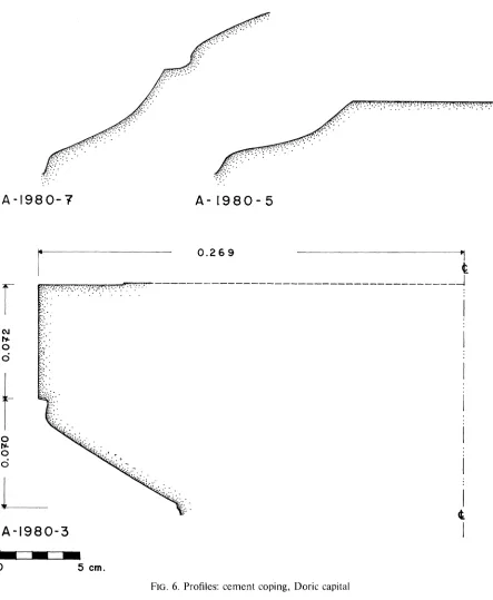
Three fragments of Classical cement with cavetto molding have been recovered from fills unrelated to the terrace but in its vicinity. These are curved in plan, with dimensions that allow them to find positions along the curve of the parabolic wall. The cement of the moldings is similar to that which is painted red on the vertical face of the wall. The fragments, A-1980-5-A-1980-7, are restored now as part of a Classical cement
23Morgan, op. cit. (footnote 1 above), pp. 550-551.
24Loc. cit., where it is suggested that the terrace supported grandstands for spectators. The terrace is considered a place for spectators and judges of the games in J. L. Caskey, Ancient Corinth. A Guide to the Excavations, 6th ed., [Athens] 1954, p. 47. M. Sakellariou and N. Faraklas, in Ancient Greek Cities, III, Corinthia-Cleonaea, Athens 1971, call it an exedra for judges (p. 98, fig. 57). The post holes used as evi- dence for scaffolding for grandstands have been sunk into the walls of the water channel on the terrace, into steps, and into the terrace in general, without respect for the shape of the terrace itself. One hole was found lined with the neck of an Apulian amphora, a shape that is late enough to be Early Roman rather than Greek. In fact, the over-all pattern of holes strongly suggests that the holes which have been thought to be Greek are, rather, to be associated with levels that are post 146 B.C.
coping of the terrace wall in its early phase (Fig. 6). One of the fragments was found in
modern fill; the other two were recovered from strata dated within the 3rd century B.C.
One might imagine, therefore, that a crowning molding of cement on the terrace wall was destroyed and discarded when the water channel and basins were added to the terrace. This alteration of the terrace is considered to have been made with the con-
struction of the Hellenistic starting line, i.e., after the mid-3rd century B.C. (see below,
p. 18).
The only monument associated with the design of the parabolic terrace stood at the very southeast limit of the space, with the central area itself kept free and unencum- bered. In fact, the free area appears to have been defined by the water channel and basins encircling the terrace. It is here suggested that the terrace was designed in this form for athletic events, such as the pankration, wrestling, and boxing. The majority of the spectators would have stood or sat on temporary bleachers erected over the race track. There they would have watched the competitors as they fought on the open terrace, which rises 0.70 to 0.80 m. above the track. Other spectators would have clus- tered at the south side of the ring, which is here defined by the channel and newly excavated basin on the terrace. From that side they would have witnessed the events from the slope above the terrace.
If the parabolic platform is considered to have been used as a ring for athletic competitions, the post holes sunk into the race track north of the platform can be explained as having been used for the temporary bleachers. Post holes were found at every level and at almost every place within the limits of the 1980 excavation. Many at high levels used Apulian amphora necks to reinforce their sides. These holes are differ- ent in a number of ways from the holes cut into the track surfaces. All of those at the track level are of Classical and, probably, Hellenistic date and were exposed during the clearing of different levels of running surface. These holes appear each to have been used only once, thereafter filled and frequently plugged with a cobble or two. The holes were not all used at the same time, for different sets of holes were sealed under differ- ent crusts of poros. Unfortunately, roots of weeds and flowers have penetrated and softened many of the running surfaces since the excavations of 1937. As a result the precise pattern of posts at each poros level could not be isolated within the few grid sections of running surface that were cleared this year (PI. 3). To judge from the exca- vation of 1980 the holes do not appear to exist farther north than 13 meters from the parabolic terrace. If temporary stands or ikria had been erected around the terrace for
spectators to witness physical-contact sports, then the cobbled paving at the base of the
terrace wall was used as a walkway similar to that which is found between the orchestra circle and the cavea of the usual Hellenistic theater.
The steps that project westward from the west end of the terrace wall lie parallel to the axis of the Hellenistic track and appear to date from the period when the early track and starting line were reoriented. Numismatic evidence recovered during the excava- tions of 1970 in the Sacred Spring indicates that the change in orientation of the track
CORINTH: EXCAVATIONS OF 1980
of earth laid down with the building of the steps, was excavated. It contained no mold- made relief bowls, yet it had in it examples of kantharoi, bowls, and plates that should
be dated within the second and third quarters of the 3rd century.25 The fill and the steps
might best be dated within the third quarter of the century.
That the steps had an earlier phase, however, is indicated by steps had aorientation earlier phase, however, is indicated by the orientation of the the west arm of the cobbled walk that surrounds the terrace wall. This segment of cobbling and, probably, an early flight of steps that rose from along the south side of this pave- ment, but is now removed, had extended at a more acute angle from the terrace than do the stairs built in the 3rd century (PI. 4:e). The original angle was determined by the course of a road that rose from the lower Lechaion Road Valley and turned above the
cliff of Peirene to pass south of the terrace. Th i s discussed more fully below as
part of the general network of streets of the southeastern valley (see p. 22).
The precise chronological history of the parabolic terrace cannot be documented.
Because the terrace wall that surrounds terrace wall that surrounds the pbedrock the of the
sloping hillside, no construction fill was recovered by which to date the initial phase. One small test trench at the west end of the cobbled walkway provided some sherds.
These indicate a date of the late 5th-early 4th century B.C. for the laying of the cobbles
and their surrounding poros curbing.26 One knows as well from two other facts that the
cobbled paving predates the Hellenistic race track: First, the cobbled walk was buried by the laying of the Hellenistic earth track. Second, the northernmost part of the terrace was trimmed back so that the terrace wall would not project into the southernmost lane of the Hellenistic track.27
The water channel that runs along the top of the terrace wall appears to be an alteration of the original fabric of the terrace, made, probably, when the Hellenistic track was laid out. The one basin of the system that sits against the terrace wall does not bond with that wall. In fact, the cement wall coat, painted red at this point, is still preserved on the wall behind the basin. The water channel, once past the terrace, is seen to be built into the Hellenistic starting platform (see above, p. 12). Thus it might be deduced that the channel was laid simultaneously with the construction of the Helle-
nistic track, probably in the third quarter of the 3rd century B.C.
25For the numismatic evidence, see C. K. Williams, II and Joan E. Fisher, "Corinth, 1970: Forum Area," Hesperia 40, 1971, pp. 16-51, esp. p. 22; p. 43, no. 139.
For the material associated with the steps, see Pottery Lots 1980-128 and 1980-129. The upper level, Lot 1980-128, apparently was slightly disturbed by Roman levels of the forum; the fill contains one sherd from an Eastern Sigillata A hemispherical bowl and one from an imbricated molded relief bowl. The fill contains four coins: 1980-126-1980-129. The uncontaminated fill behind the steps, Lot 1980-129, contains no molded relief bowls but has in it one West Slope plate with offset rim, nine stamped amphora handles, and 16 coins: 1980-132, 1980-134-1980-137, and 1980-141-1980-150.
26Pottery Lot 1980-139.
27Morgan, op. cit. (footnote 1 above), p. 551, where the cuttings are said to be for the redesigned racecourse. See Broneer, Hesperia 11, 1942, p. 14, for the opinion that the trimming was made by wear from chariots. The straightness of the cutting back of the wall and the lack of wheel marks anywhere close to the wall make the second interpretation less attractive than the first.
THE CIRCULAR MONUMENT (Pis. 2, 5)
A large circular drum, set upon four courses of rough ashlar foundations, domi- nates the southeast extremity of the parabolic terrace (PI. 5:a). The diameter of the drum is 2.10 m., its height 1.35 m. The monument has been considered Roman, with
its initial construction dated ca. 15 B.C.28 Because of the excavation into Classical levels
which was done this year, it is now considered probable that the monument is Greek
and of the 5th century B.C. None of the following conclusions, however, invalidates the
Roman phases of the monument as published by Scranton.
The rectangular podium of foundation blocks upon which the drum sits is in no way oriented to agree with the walls of the neighboring Roman buildings, neither the Central Shops building, the terrace behind it, the Julian Basilica, nor the Southeast Building. Indeed, all of these Roman buildings are later in date than the circular monu- ment; but the Romans expended much effort to disguise the rectangular foundation that supported the drum once they started to build in this part of the forum. The po- dium is not even oriented in respect to the Early Roman stoa above the cliff of Peirene
(see below, p. 27, also PI. 2), nor to the 4th-century B.C. South Stoa.
The the poe sition ofpodium the podium of the circular monument is related to the arm of the
early Classical Lechaion Road Valley thoroughfare that turns toward the southeast and passes south of the parabolic terrace and the circular monument (see below, p. 22, also Figs. 1, 2). Its orientation is almost parallel to the 5th-century built drain that defines the south side of that road and to the 4th-century built drain that replaced the earlier one. There is also a direct relationship between the orientation of the podium and the western arm of the cobbled paving that is associated with the parabolic terrace upon which the monument stands. All seem to be contemporaneous and should be dated before the Hellenistic race track and the South Stoa had established the new orientation for the architecture of this area, which was also followed in the Roman period.
With the possibility in mind that the circular monument is Classical in date, one
might well reconsider the Ittar drawing of a piedistallo in Corinto.29 Dinsmoor associates
the drawing with the circular monument in question; and a comparison of measure- ments on the drawing with the dimensions of the monument itself seems to bear out the conclusion. Although drawing and monument have been associated in previous publications, there has been no discussion concerning the molding recorded in the Ittar drawing but missing on the monument itself. The molding would have been on the drum of the monument, which was broken up by villagers hungry for building material. The drawing shows a hawksbeak above a simple fascia. The hawksbeak is pre-Hellenistic in profile, with a groove dividing molding from fascia. The height of the hawksbeak is greater than its projection, and, although not paralleled by other published moldings, it may well be a profile peculiar to Corinth, with its quick concave turn under the projec-
CORINTH: EXCAVATIONS OF 1980
tion.30 All in all, the molding does not look to be any later than the last quarter of the 5th century, and probably is earlier. Certainly the molding, as recorded, cannot be Hellenistic or Roman, unless the base was erected as a copy of a Classical original.
If the circular monument is accepted as Classical, then the terrace wall 3.50-3.80 m. to its south also should be considered Greek rather than Roman, along with the two smaller poros foundations, apparently for monuments, at the south side of the wall. All are oriented similarly, and neither the tooling nor the construction techniques suggest a Roman date.
The above evidence suggests that a large circular monument, supporting tripod or statue, stood on a rectangular base, only the core of which is still preserved, at one edge of the parabolic terrace, probably with a series of monuments or dedications set along the terrace wall and roadway that run south of the terrace.
CONCLUSION
Sparta supplies a parallel for the Corinthian complex of combat ring, racecourse, sanctuaries of gods and heroes, and an assortment of monuments and statues. Pausani- as mentions the Spartan racecourse as "the place where it is the custom for the young
men even down to the present day to practice running."31 Near the course was the
Platanistas, apparently a circular, or at least not rectangular, combat area surrounded, however, by a moat. Among other things, the Platanistas was used for a festival which
was celebrated with a mass pankration-like competition. Pausanias notes various heroa
and sanctuaries in the area, close to the track and the Platanistas. The whole complex was distant from the agora of the Lakedaimonian city, apparently more so than are the Corinthian track and platform for physical-contact sports from the Corinthian agora, assuming, of course, that the Corinthian agora lies somewhere north or northeast of Temple Hill.
The Spartan example is here cited as an illustration of a possibly parallel complex in
a non-central position within a city. The existence of an open athletic area within the city of Corinth need not imply the coexistence there of the city's agora.32
THE ROAD SYSTEM OF THE SOUTHEAST VALLEY (Figs. 1-3)
Because only scattered information is available concerning the topography of the Classical city beyond the central excavation zone, it is difficult to understand the full significance of the various roads that radiate from the Lechaion Road Valley. The thor- oughfare that disappears from the southeast corner of the excavation zone, the second
30Compare the Ittar drawing with hawksbeak profiles from epikranitis and monument crowns in L. T. Shoe, Profiles of Greek Mouldings, Cambridge, Mass. 1936, pp. 116-129, pls. LVI-LXI.
3Pausanias, III.14.6-15.2. I thank D. G. Romano for having brought this parallel to my attention. 32Williams, Hesperia 39, 1970, pp. 32-39.
that extends south toward Akrokorinthos from the southwest corner of the archaeologi- cal zone, and the one between those two, which continues southward as an extension of the main north-south artery of the Lechaion Road Valley, all were important routes for the circulation pattern of the city and were in use by the early Classical period, if not earlier. The extension southward of the central route of the Lechaion Road Valley beyond the Heroon of the Crossroads, although established early, was terminated with the construction of the South Stoa, a long building which eliminated north-south com- munication across most of the south slope of the upper Lechaion Valley after the third
quarter of the 4th century B.C.
A diagonal road, which branches to the southeast above the cliff of Peirene and rises along the slope immediately south of the parabolic terrace, connects the north- south artery of the Lechaion Road Valley with the road at the east side of the excava-
tion area. This branch was laid in the 5th century B.C. but probably had a predecessor,
all evidence of which has been eliminated by the grading of bedrock. The construction of an elaborate poros conduit along the south side of this diagonal road is one with the cutting down of the slope. The conduit served not only as a water channel but as a ter- race wall for the stabilization of the very soft, sandy bedrock at the south side of the road.
The conduit was built with a floor of large, thin slabs, laid almost as a sidewalk (PI. 5:b). The blocks range in thickness between 0.07 and 0.20 m., in width between 0.43 and 1.28 m., in length between 0.87 and 1.00 m. Along either side of the slabs runs a flat, chisel-dressed bed, upon which were set narrow side walls of poros, leaving an open drain-bed width of about 0.60 m. The south side of the drain was fitted snugly against the cut-back bedrock of the hillside. Poros slabs probably spanned from side wall to side wall at a height that would not have protruded above the top of the slope but, rather, would have been flush with it.
Only the floor slabs of the conduit or drain are preserved. These have been deeply eroded by water in some places, worn by wheeled traffic in others. The fill of gravel and washed sherds in the eroded areas of the paving suggests a 5th-century date. This mate- rial probably is from the period of use of the conduit. The wheel ruts worn into the stone slabs and their associated road metal suggest that the drain was dismantled by the end of the century.
CORINTH: EXCAVATIONS OF 1980
The changed position of the drain allowed the southeast-northwest roadway to extend its southern limit; immediately south of the road and the drain was erected at least one new building, of which now only a large stretch of cement floor, a well, and foundation trenches are preserved.
The existence of a building sited along the south side of the roadway and drain vividly illustrates the fact that the open part of the upper valley, at least above Peirene, was limited to the vicinity of the racecourse and to the north side of the road. Houses apparently built in city blocks occupied the area south of the road. This pattern of land use was maintained here until the second half of the 4th century when the South Stoa was constructed and a general change was made in the area. Only then was the open space
around the racecourse expanded beyond the limits of the southeast-northwest road.
Little new excavation was undertaken this year to clarify the form of the city blocks south of the road or the plan of the building itself. In fact, little new excavation has been done here since the discovery of the structure in the 1933 excavation season.33 At that time a pebble-aggregate cement floor was uncovered behind rooms 4-7 of the Roman Central Shops, but the north side of this floor and the north facade of the building had been destroyed by the Roman shQps, as had its northwest corner. The south side of the Classical building still lies under unexcavated fill.
The pebble-cement floor or originally abutted the east wall of the structure and now is
preserved for an uninterrupted length of a little under seven meters toward the north- west. The floor lies at an elevation between 78.72 and 78.77 m. above sea level. Along the eastern edge of the floor are preserved traces of what had been a bench 0.45 m. wide, originally built against the west face of the east wall of the building. The southern limit of the cement floor is defined by a cutting in bedrock for the foundations of a wall. At about 1.20 m. south of the cutting is a well shaft, also cut into bedrock, along with a
Classical lekane set in the earth for water drawn from the well.34 The well, 1980-1, had
been discovered by the end of the 1933 excavation season. No record has been located that describes its contents.
Among the other visible remains associated wih the building is a small poros drain, running at surface level toward the north and, probably, flowing into the large drain in the 4th-century road. The small drain runs parallel to the east wall of the building; this arrangement, which serves to lead off water from between houses, is commonly found within Corinth city blocks.35
The construction of this second large drain is part of a general redevelopment of
the area south of the parabolic terrace. No stratigraphic evidence, however, exists from
excavation this year to indicate whether or not this reconstruction was undertaken in
33The only published mention of the building is in Scranton, Corinth I, iii, p. 75, where it is referred to as Greek floors behind Shop VII of the Central Shops; it is not on plan J of that volume.
34 Deep lekane C-1980-161, with ring foot, horizontal rim, bands in red and brown-black, triangles on rim. 35Compare with the arrangement between Buildings I and II, II and III. See plan in C. K. Williams, II, "Corinth, 1971: Forum Area," Hesperia 41, 1972, p. 166, fig. 5.