THE INFLUENCE OF DIFFERENT PROCESSING PARAMETERS ON
ESTIMATED VARIATION OF GPS POSITIONING
Mohd Hafiz Yahya and Md Nor Kamarudin
Department of Geomatics Engineering Faculty of Geoinformation Science and Engineering
Universiti Teknologi Malaysia Skudai, Johor, Malaysia Tel: 075530941 Fax: 075566163
Email: [email protected]
Abstract
Throughout the past decades, GPS has been responsible much of the present infrastructure and thus being widely used covering from the diverse low cost and recreational uses to highly accurate and professional applications. Level of performance produce by this ingenious space-based positioning system however, is often a function of equipment suitability, measurement technique, error modelling and satellite signal geometry. Data processing complexity is also one of the main factors contributing to the erroneous and discrepancies in the GPS derived positions. This paper highlights the influence of three different processing parameters namely ephemeris type, elevation cut-off angle and earth rotation parameter towards the estimated variation of GPS positioning discrepancies. As each station experiencing low multipath conditions and excellent views of all available satellites, series of RINEX data retrieved from five continuously operating Malaysian Real-time Kinematic Network (MyRTKnet) stations namely JHJY, KLUG, JUML, MERU and LGKW were used. Based on the results, it is suggested that GPS derived positions varies with variation on the ephemeris type and elevation cut-off angle. As far as earth rotation parameter is concerned, it is totally ignorable in most practical cases as no variation detected throughout the observation period.
Keywords: batch processing interval, earth rotation parameter, elevation cut-off angle
1.0 INTRODUCTION
SINGAPORE
MERU
JUML
KLUG
JHJY
THAILAND
LGKW
JUML
Lat: 2 12 42.31716 Long: 102 15 21.94962 H: 19.807
MERU
Lat: 3 8 17.65238 Long: 101 24 H: 26.83975
KLUG
Lat: 2 1 31.36250 Long: 103 19 0.52025 H: 73.607
JHJY (Base)
Lat: 1 32 12.51889 Long: 103 47 47.51012 H: 39.206
LGKW
Lat: 6 19 42.60797 Long: 99 51 4.53958 H: 26.83975
SUMATRA
2.0 THE EXPERIMENT
2.1 Data Acquisition
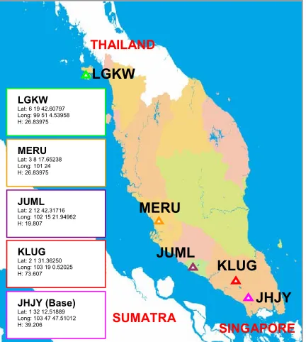
Series of RINEX data retrieved from five continuously operating Malaysian Real-time Kinematic Network (MyRTKnet) were used throughout the study. These stations include Johor Jaya (JHJY), Kluang (KLUG), JUPEM Melaka (JUML), Meru (MERU) and Langkawi (LGKW). Apparently, all selected MyRTKnet stations are well-equipped with 5700 Trimble dual frequency geodetic GPS receivers with Zephyr Geodetic type antennas (Ali et al. 2006). The quality of the data retrieved from these stations is expectedly high, with each station experiencing low multipath conditions and excellent views of all available satellites. Located at the southern part of peninsula Malaysia, JHJY was selected as a reference in relative to other corresponding stations. The distance between KLUG, JUML, MERU and LGKW stations in relative to JHJY are respectively sufficient to signify short baseline (50 km), medium baseline (98 km), long baseline (193 km) and very long baseline (687 km). Furthermore, these baselines are best to represent the geographical condition in Peninsula Malaysia in which stretching from about 1 degree to 6 degrees latitudes. Figure 1 illustrates the geographical locations of the abovementioned stations.
Figure 1: Distribution of Selected MyRTKnet Stations
2.2 Processing Methodology
( ) ( ) ( )
(
)
12 2 2 2
3DError = ∆E + ∆N + ∆H
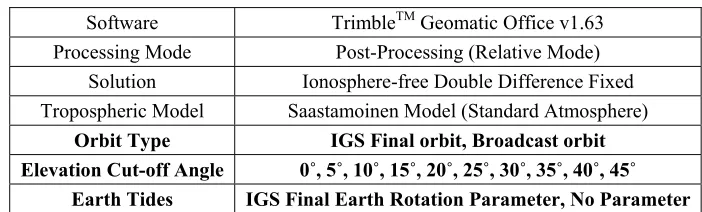
Table 1: Summary of Processing Parameters
Software TrimbleTM Geomatic Office v1.63
Processing Mode Post-Processing (Relative Mode) Solution Ionosphere-free Double Difference Fixed Tropospheric Model Saastamoinen Model (Standard Atmosphere)
Orbit Type IGS Final orbit, Broadcast orbit Elevation Cut-off Angle 0˚, 5˚, 10˚, 15˚, 20˚, 25˚, 30˚, 35˚, 40˚, 45˚
Earth Tides IGS Final Earth Rotation Parameter, No Parameter
2.3 Data Analysis
As tabulated in Table 1, the so called “parameters of interest” includes ephemeris types, elevation cut-off angles and earth rotation parameter. To gauge the contribution of these processing parameters to variation in discrepancies of GPS derived positions, each case is then estimated and analyzed in term of 3D error based on Equation (1).
(1)
where:
∆E : Error in Easting component ∆N : Error in Northing component ∆H : Error in Height component
3.0 RESULT
3.1 Ephemeris Data
Figure 2: Computed 3D Error as a Function of Orbit Type
The result indicates that precise orbits tend to contribute better results in the computation of GPS derived positions in comparison to broadcast orbits. As opposed to broadcast orbits, on Day 284, the maximum variation from the use of the precise orbits is about 2.6 cm or 69 percents.Improvement on the order of about 0.4 cm or 44 percents is seen on the previous observation period (Day 283), followed by 1.1 cm or 45 percents, on Day 285. To further understand the variation of this parameter, computed 3D error was then calculated as a function of four different baselines; short baseline (JHJY-KLUG), medium baseline (JHJY-JUML), long baseline (JHJY-MERU) and very long baseline (JHJY-LGKW) given specific observation period. Figure 3 depicts the result of the study.
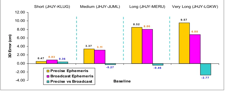
Figure 3: Computed 3D Error as a Function of Orbit Type and Baseline Length
Even so 3D measurement error increases with the increases distance over two reference stations; there are interesting correlations between the functionality of these orbit types and GPS baseline length. Short baseline (JHJY-KLUG) tends to evident the benefit of using the precise orbits. Longer baselines on the other hand considerably indicate better results of not using precise orbits. The variation of 3D measurement errors computed from both medium (JHJY-JUML) and long baselines (JHJY-MERU) range within decimal level of 0.3 cm to 0.5 cm. Similarly, although it is not that apparent for both aforementioned baselines, the largest and most noticeable variation of using broadcast orbits, is detected on the very long baseline (JHJY-LGKW). With a baseline length of about 687 km, positioning variation on the order of 2.8 cm or 29 percents is detected. Again using both precise and broadcast ephemeredes, Figure 4 (a, b and c) visualize the variations in term of Easting, Northing and Height components of GPS derived positions over similar observation period.
0 .4 7
3 .3 7
8 .5 2
9 .5 7
0 .8 3
3 .11
8 .0 6
6 .8 0
0 .3 6
- 0 .2 7 - 0 .4 6
- 2 .7 7
-4.00 -2.00 0.00 2.00 4.00 6.00 8.00 10.00 12.00
Short (JHJY-KLUG) Medium (JHJY-JUML) Long (JHJY-MERU) Very Long (JHJY-LGKW)
Baseline
3D
E
rro
r (
cm
)
Precise Ephemeris Broadcast Ephemeris Precise vs Broadcast
0.46
1.16 1.35
0.96
1.66
0.82
3.76
2.47
1.26
0 .3 7 0.36
2 .6 0
1.12
0 .3 1
1.29
0.00 0.50 1.00 1.50 2.00 2.50 3.00 3.50 4.00
282 283 284 285 286
Year 2006 (day)
3D
E
rro
r (
cm
)
Precise Ephemeris Broadcast Ephemeris
0 .4 0
1.4 6
8 .4 3 9 .17
0 .8 0 0 .4 6
7 .16
5 .4 8
0 .4 0
- 1.0 0 - 1.2 7
- 3 .6 9
-6.00 -4.00 -2.00 0.00 2.00 4.00 6.00 8.00 10.00
Short (JHJY-KLUG) Medium (JHJY-JUML) Long (JHJY-MERU)
Very Long (JHJY-LGKW) Baseline H ei g h t E rro r (c m ) Precise Ephemeris Broadcast Ephemeris Precise vs Broadcast
Figure 4 (a): Computed Easting Error as a Function of Orbit Type and Baseline Length
Figure 4 (b): Computed Northing Error as a Function of Orbit Type and Baseline Length
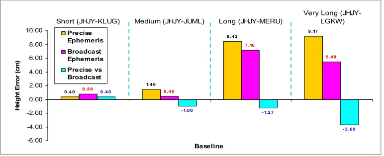
Figure 4 (c): Computed Height Error as a Function of Orbit Type and Baseline Length
0 .12 0 .2 7
0 .6 8
2 .0 5
0 .2 0 0 .2 9
2 .5 2
3 .2 1
0 .0 8 0 .0 2
1.8 4 1.16 0.00 0.50 1.00 1.50 2.00 2.50 3.00 3.50
Short (JHJY-KLUG) Medium (JHJY-JUML) Long (JHJY-MERU)
Very Long (JHJY-LGKW) Baseline N o rt h in g E rro r ( cm ) Precise Ephemeris Broadcast Ephemeris Precise vs Broadcast
0 .2 2
3 .0 3
1.0 3
1.8 3
0 .0 1
3 .0 6
2 .7 2
2 .4 4
- 0 .2 1
0 .0 3
1.6 9
0 .6 1
-0.50 0.00 0.50 1.00 1.50 2.00 2.50 3.00 3.50
Short (JHJY-KLUG) Medium (JHJY-JUML) Long (JHJY-MERU)
3.2 Elevation Cut-off Angles
Another parameter to be taken into account in data processing is the elevation cut-off angle. Often denoted to elevation mask angle, it is a setting for the tracked satellites angle in relative to the receiver’s antenna. As signal perturbation is most likely within unfavourable observation surrounding (i.e. reflective surface, blocked structure), it is suggested that high elevation cut-off angle removes noisy data and therefore improves baseline statistics. Furthermore, signals transmitted from low elevation satellites need to propagate through longer atmosphere and are subject to ionospheric and tropospheric effects. Multipath effect is also much more pronounced among low elevation satellites than signals that are directly overhead. Exclusion of low orbiting satellites is therefore needed to ensure the performance of GPS measurement. To further comprehend the effect of different elevation cut-off angle on computed 3D error, a study was conducted based on three respective periods (Day 283 to 285). Different elevation cut-off angles were set ranging from 0 degree to 45 degrees. With a constant batch processing interval from 8 am to 9 am at JHJY-KLUG baseline, estimated variation of GPS positioning induce by different elevation cut-off angle are as shown in Figure 5.
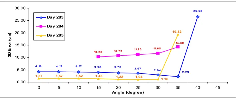
Figure 5: Computed 3D Error as a Function of Elevation Cut-off Angle
For this particular result, the distributed 3D error varies as a function of elevation cut-off angles. Although no fixed solution can be made at 45 degrees angle during all observation period, on Day 283, an increase in elevation cut-off angle gradually improves the computed 3D errors. The best computed GPS position is detected at the 35 degrees angle with 2.3 cm accuracy, or 45 percents of improvement in comparison to 4.2 cm at 0 degree angle on the same day. Nevertheless, once the elevation reaches 40 degrees angle, an excessive 3D positioning displacement of 26.6 cm is detected and hence should be avoided. An increase in elevation cut-off angle on Day 284 on the other hand, decreases the accuracy level obtained from the GPS data processing. Generally produced less accurate measurement in comparison to Day 283, the best computed GPS position is detected at the lowest possible angle of 15 degrees, given that only float solution can be produced for the first and last 10 degrees. Although on Day 285, similar pattern to Day 283 is detected (in which an increase in elevation cut-off angle gradually improves the measurement accuracy), for this particular case however, sudden fluctuation is detected at 35 degrees angle. To extend the understanding on the variation of this parameter, computed 3D errors were then calculated as a function of both elevation cut-off angle and observation period. Analyses were made based on hourly interval on Day 283 from 8 am to 4 pm. Figure 6 depicts the result of the study.
4 .19 4 .19 4 .12 3 .9 6 3 .7 6
3 .6 7 2 .9 4
2 .2 9 2 6 .6 2
10 .2 8 10 .7 3 11.2 5 11.6 5
14 .3 0
19.32
1.16 1.04
1.22 1.43 1.57 1.57 1.52
0.00 5.00 10.00 15.00 20.00 25.00 30.00
0 5 10 15 20 25 30 35 40 45
Angle (degree)
3D
E
rro
r (
cm
)
Day 283
Day 284
Figure 6: Computed 3D Error as a Function of Elevation Cut-off Angle and Observation Period
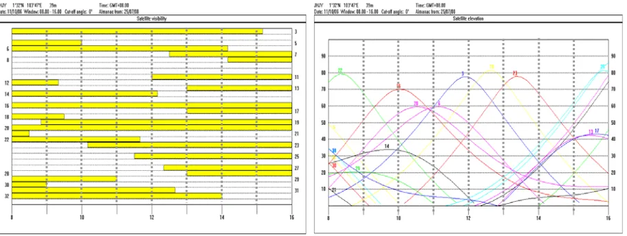
As mentioned earlier, the need for elevation cut-off angle is to characterize the level or viewpoint from where visible satellites in reference to the receiver will be included. Due to the relative motion of the orbiting satellites, inappropriate selection of elevation cut-off angle induces discrepancies in GPS derived positions. Before or even after (in a case where no solution available at 0 degree) reaching to sudden fluctuation, float or even no wave solution due to insufficient amount of satellites (minimum of four satellites is needed to obtain one 3D position), it is suggested that increase in elevation cut-off angle gradually improves the measurement accuracy. In most cases, it is also noted that within 20 to 30 degrees angle, the 3D errors tends to be at the smallest amount. This might be due to the fact that only good and ‘healthy’ satellites are included within this observing angle. To justify the significant of elevation cut-off angle setup with variation in satellite visibility, Figure 7 illustrates the relative motion of the orbiting satellites over similar observation period (Day 283) at JHJY-KLUG baseline.
Figure 7: Multi Station Analysis on Satellite Visibility and Elevation
Here, strong correlation between elevation cut-off angle setup (Figure 6) and satellite condition (Figure 7) over similar observation period is detected. Provided that enough satellites with high elevation are available at that particular period, it is suggested to use high elevation cut-off angle in substitute of low elevation angle. In a situation where fewer amounts of satellites are available, the inclusion of low elevation satellites however, should be considered. As signals transmitted from low elevation satellite are more susceptible to multipath and atmospheric disturbance, appropriate site selection with multipath-resistant antenna is therefore recommended.
0.00 5.00 10.00 15.00 20.00 25.00 30.00
8 9 10 11 12 13 14 15
Day 283 (hour)
3D
E
rro
r
(c
m
)
0 Degree
10 Degree
20 Degree 30 Degree
3.3 Earth Rotation Parameter
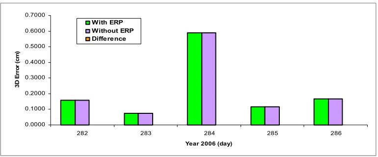
Another parameters used in data processing is the earth rotation parameter (ERP). ERP generally consists of pole position and UT1-UTC along with the conventions for sidereal time, precession and nutation. Normally provided in three types of grouped parameters (i.e. polar motion, polar motion rates and length of day), ERP can be estimated either using VLBI or continuous GPS monitoring. ERP file can be downloaded via IGS website at no direct charge. Detail descriptions of ERP are as discussed in Hinnov (2004). ERP in general is used to mitigate the effect of pole tide (details on pole tide mathematical expression is as discussed in IERS (1996)). Schuler (2001) asserts that site deformation due to polar motion can reach a maximum radial displacement of about 2.5 cm. Nevertheless, this so called effect is noted to be highly dependent on the site location. In order to investigate the significant of using ERP towards variation in GPS positioning accuracy within the area of selected reference stations, analyses were made based on JHJY-LGKW baseline processed on five corresponding observation period. For the purpose of study, final ERP were used in which can be obtained at about 13 days latency. Results of the study are as shown in Figure 8.
Figure 8: Computed 3D Error as a Function of Earth Rotation Parameter
Apparently, based on this particular case, the use of ERP however had no effect on the GPS derived positions. 3D errors induced either by using ERP or without using ERP throughout the observation campaign (Day 282 – Day 286) are entirely similar. The use of ERP during data processing is therefore can be neglected for most practical cases including local high accuracy GPS surveying.
4.0 CONCLUSION
This aim of this paper is to investigate GPS positioning variation caused by differences in orbit types, elevation cut-off angles and earth rotation parameters. Based on the analyses (see Figure 2 – Figure 8) conducted within series of RINEX data retrieved from selected continuously operating MyRTKnet stations, several conclusions are made:
1. GPS derived positions varies with variation on the orbit types. Furthermore, 3D measurement error caused by different orbit types increases with the increases distance over two reference stations. As the estimated variation evidently depends on the baseline length, the largest and most noticeable variation on the order of 2.8 cm is detected on the very long baseline of about 687 km.
2. GPS derived positions varies with variation on the elevation cut-off angle. Depending on the relative motion of the orbiting satellites, it is suggested that increases in elevation cut-off angles gradually improve the measurement accuracy. In most cases, it is also noted that within 20 to 30 degrees angle, the 3D errors tends to be at the smallest amount. In a situation with
0.0000 0.1000 0.2000 0.3000 0.4000 0.5000 0.6000 0.7000
282 283 284 285 286
Year 2006 (day)
3
D
E
rro
r (
c
m
)
low satellites visibility, the inclusion of low elevation satellites however, should be considered.
3. As far as earth rotation parameter is concerned, it is totally ignorable in most practical cases as no variation detected on the accuracy of GPS positioning throughout the observation period.
The results of this study are not suggested to apply in all situations. To effectively quantify the significant of these parameters in data processing, the use of massive amount of data is highly recommended. The results shown in this paper however are likely to be duplicated and simulated under similar responsible conditions.
5.0 ACKNOWLEDGMENT
The authors would like to acknowledge the Geodesy Section, Department of Surveying and Mapping Malaysia (DSMM), Scripps Orbit and Permanent Array Center (SOPAC) and the International GNSS Service (IGS) for providing the data used in this study.
6.0 REFERENCE
Ali H, Nordin AF, Abu SH, L.H. C (2006). MyRTKnet: Get set and go! MyCoordinates
Even-Tzur G, Salmon E, Kozakov M, Rosenblum M (2004). Designing a Geodetic-Geodynamic
Network: A Comparative Study of Data Processing Tools. GPS Solution 8:30-35
Heroux P, Kouba J (2001). Precise Point Positioning Using IGS Orbit and Clock Products. GPS Solution 5(2):12-28
Hinnov LA (2004) Recent Developments and Global Correlations, Cambridge University Press Hoffmann-Wellenhof B, Lichthnegger H, Collins J (2001). Global Positioning System: Theory and
Practice, Springer, Berlin, Germany
Hugentobler U, Schaer S, P.Fridez (2001) Bernese GPS Software Version 4.2, Astronomical Institute, University of Bern, Switzerland
IERS (1996) IERS Conventions (1996), IERS Technical Note 21
Leick A (2005) GPS Satellite Surveying, John Wiley and Sons, New York
Likhar S, N.Kulkarni M, Tomar VS, Pillai P (2002). A Comparative Study of Results from GPS Data
Processing Software Asian GPS
Schueler T (2001). On Ground-Based GPS Tropospheric Delay Estimation. Universitat der Bundeswehr
International GNSS Service. http://igscb.jpl.nasa.gov/(last accessed 01/08/08) Malaysian RTK Network. http://rtknet.gov.my/(last accessed 01/08/08)