ISSN: 2319-8753
I
nternational
J
ournal of
I
nnovative
R
esearch in
S
cience,
E
ngineering and
T
echnology
(An ISO 3297: 2007 Certified Organization)
Vol. 3, Issue 6, June 2014
Agriculture Land Information System Using
Web GIS
Balamurugan.M1, Kalaiarasi.K2, Arun Prasad.S3
Department of Electronics and Communication, University College of engineering, villupuram, India1
Department of Electronics and Communication, University College of engineering, villupuram, India 2
Department of Information Technology, University College of engineering, villupuram, India 3
ABSTRACT: Agriculture continues to play a major role in Indian. With clear understanding of the soil type, fertility and other parameters related to agricultural yield, farmers can achieve better agricultural productivity. For sustainable agricultural development cultivable land information plays vital role. With detailed and reliable information, it is easier to implement better agricultural practices. With the development of sophisticated hardware and software systems, web mapping is extensively used by many organizations for their spatial data requirements. Several advancements in the system architecture and network designs facilitated enormous growth in web mapping and web cartography. Web GIS enable sharing geographical information with millions of users worldwide via internet. Agricultural Land Information System (ALSI) provides detailed information about demographic pattern of the area, spatial information, Agricultural land at various levels, road network, water Resources, soil characteristics, site characteristics and land suitability for crops at village level. This information will be very useful to the farmers, students, planners and decision makers for the integrated development of rural areas.
KEYWORDS: ALSI, GIS, Web GIS, Web, Soil, Crops.
I. INTRODUCTION
Agriculture continues to play a major role in India. Nearly 75 percent people are living in rural areas and are still dependent on Agriculture. About 43% of India’s geographical area is used for agricultural activity. The region has several hot spots of rural poverty, as most farmers in the region are small holders with diverse farming systems, which are highly risk prone. In addition, these farmers have poor access to support services such as extension, the agricultural Land
information, knowledge, technology and financial credit.The new Agricultural Land Information System brings sustainable
revolution by empowering the resource to poor farmers with up-to date knowledge and information about agricultural land and technologies, best practices, markets, price trends, consumer preferences, sources of finance, weather, soil-moisture conditions and the environment.
GIS software has enabled users to view spatial data in its proper format. As a result, the interpretation of spatial data becomes easy and increasingly simple to understand. Unfortunately, everyone does not know how to access GIS, and are not able to spend the time necessary to use it efficiently. Web GIS becomes a cheap and easy way of disseminating geospatial data and processing tools. Many organizations are interested to distribute maps and processing tools without time and location restriction to users.
ISSN: 2319-8753
I
nternational
J
ournal of
I
nnovative
R
esearch in
S
cience,
E
ngineering and
T
echnology
(An ISO 3297: 2007 Certified Organization)
Vol. 3, Issue 6, June 2014
Copyright to IJIRSET www.ijirset.com 13972
The motivation behind this project is to develop a prefetching method for increasing the performance of Web GIS and responding the client requests in an acceptable period of time in a reasonable way.
II.METHODOLOGY
A. Study area Description
Sivagangai block is located on the Northwestern part of Sivagangai district (figure 1). The area lies between 78°19' and 78°33' East longitudes and 9°45' and 10°05' North latitudes. Total area of the block is 44660 hectares, which constitutes
about 10.7 per cent of the area of the district. The block has 51 revenue villages. Village cadastral Maps and Soil statistical
measures are used in this study.
B. The ALSI Method
The architecture of our Web-tool is shown in (figure1) consisting of map services, data services, meta data and other information (e.g. photographs).
These included soil data from the Soil Survey Geographic Database (Natural Resource Service), land use/land cover and Land suitability for crops.
Fig1: Architecture for ALSI System
We customized a GIS package in an intranet environment to meet the needs of the ALSI. The next stage was to include the new GIS functionalities in a restricted access website. The web pages are generated dynamically on the server side by retrieval of appropriate information from the constantly updated database. The website was built with CSS, HTML pages, PHP, Active Server Pages (ASPs). We have used Internet Information Server as web server.
III. RESULTSANDDISCUSSION
ISSN: 2319-8753
I
nternational
J
ournal of
I
nnovative
R
esearch in
S
cience,
E
ngineering and
T
echnology
(An ISO 3297: 2007 Certified Organization)
Vol. 3, Issue 6, June 2014
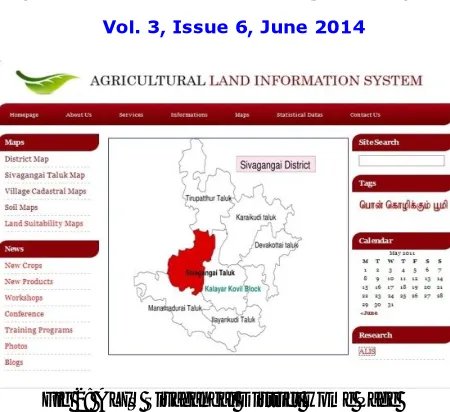
Fig 2: ALIS Sivagangai District Home Page
The user can view the cadastral map of any village in the block by just clicking on the name or the sitemap. It contains the name of the all 51 villages in the sivagangai block.
Fig 3: ALIS Sivagangai Block Village Information
The detailed information about the village can be viewed by all. The information includes
1. Survey number
2. Soil and site characteristics
ISSN: 2319-8753
I
nternational
J
ournal of
I
nnovative
R
esearch in
S
cience,
E
ngineering and
T
echnology
(An ISO 3297: 2007 Certified Organization)
Vol. 3, Issue 6, June 2014
Copyright to IJIRSET www.ijirset.com 13974
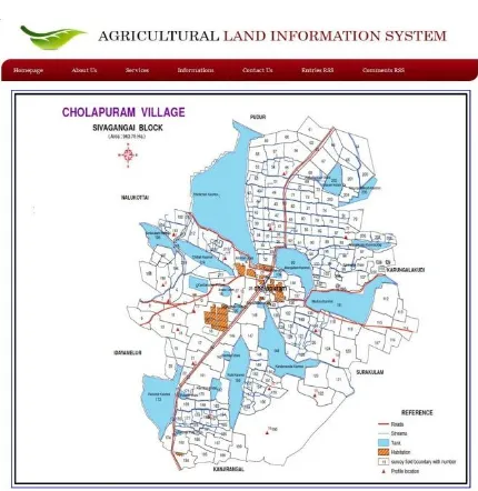
Fig 4: Cholapuram Cadastral Map based ALIS Information
It provides the facility to download the cadastral and soil maps for any given village in the sivagangai block. The pages allows the user to get the land suitability, soil & site characteristics data, Land suitability for various crops and horticultural crops of the particular survey number in a chosen villages.
Fig 5: Soil and Site Characteristics for chollapuram village Survey no 190
ISSN: 2319-8753
I
nternational
J
ournal of
I
nnovative
R
esearch in
S
cience,
E
ngineering and
T
echnology
(An ISO 3297: 2007 Certified Organization)
Vol. 3, Issue 6, June 2014
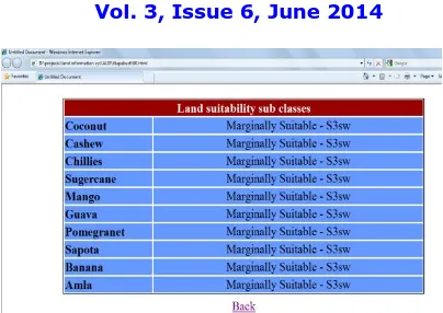
Fig 7: Land suitability (Horticultural) for Illupakudi Village Survey no 90
IV.CONCLUSION
In this work a Web GIS (geographic information system) is used which provides a real time and dynamic way to represent information about Agricultural Land infrastructural facilities at village level through maps and statistics. It provides detailed information about demographic pattern of the area, spatial information, Agricultural land at various levels, road network, water Resources, soil and site characteristics and land suitability for crops at village level.
ALIS has been found to be extremely useful in mapping and planning of agricultural land information in
sivagangai block of sivagangai district. This information will be very useful to the farmers, students, planners and decision makers for the integrated development of rural areas. The methodology developed can be used for district level too. Web GIS framework has been developed for spatial planning of infrastructural facilities in rural areas of sivagangai district. The farmers, planners and decision-makers who do not have in depth knowledge of GIS functioning can also use the developed Web GIS to improve the efficiency of planning process in sivagangai district.
This project is providing the web based Agricultural information's on soil characteristics and Land suitability for different types of Crops. This system will solve the decision making problem very much in agricultural economics research through web based.
This ALIS will be useful for different organizations like soil survey department and agricultural department in order to make an efficient system for agricultural management activities.
REFERENCES
1. R. Abd El-Kawy, H.A. Ismail, J.K. Rød, A.S. Suliman (2010) ‘A Developed GIS-based Land Evaluation Model for Agricultural Land Suitability Assessments in Arid and Semi Arid Regions’ Research Journal of Agriculture and Biological Sciences, 6(5): 589-599, INSInet Publication. 2. Bas Vanmeulebrouk, Deack Melman, Alex Schotman (2009) ‘Application of Open Source and Proprietary software to Optimise meadow bird
management schemes in Nether lands’ International journal of Geographical information science, 20,8,885-898.
3. S. Bandyopadhyay, R. K. Jaiswal, V. S. Hegde and V. Jayaraman (2009) ‘Assessment of land suitability potentials for agriculture using a remote sensing and GIS based approach’ International Journal of Remote SensingbVol. 30, No. 4, 20 February, 879–895.
4. O.Fajuyigbe, V.F. Balogune (2007) ‘Web Based Geographical Information System (GIS) for Tourism in Oyo State, Nigeria’ Journal of Information Technology 6(5): 613-622.
5. Dr. Y.K. Gupta, S. Grunwaldb,(2005) Dr. R.D Gupta, K. Kumar ‘WebGIS for Planning Infrastructural Facilities at Village Level’ Journal of ELSEVIER, Computers and Electronics in Agriculture.
6. Xu Haiyan , NieYimin (2005) ‘Constructing Digital Information Platform based on WebGIS for Safety Vegetable Production’ Journal of Agriculture science in chinese(192): 108-112.
7. Xu Haiyan , NieYimin (2005) ‘GIS Based Decision Making System for Agriculture’ Journal of Agriculture science in chinese,(214): 115-118. 8. Inés Santé a, Rafael Crecente a, David Miranda a, Juan Touriño b, Fernando Canzobre b “A GIS web-based tool for the management of the PGI
potato of Galicia(2004)” Journal of ELSEVIER, Computers and Electronics in Agriculture.
9. Irene Compte, Antoni Hernández , Francesco Marucci, Ferran Orduña (2004) ‘SIGFRUT: a WEBGIS application for designing agricultural plantations and installations’ Journal of ELSEVIER, Computers and Electronics in Agriculture.
ISSN: 2319-8753
I
nternational
J
ournal of
I
nnovative
R
esearch in
S
cience,
E
ngineering and
T
echnology
(An ISO 3297: 2007 Certified Organization)
Vol. 3, Issue 6, June 2014
Copyright to IJIRSET www.ijirset.com 13976
11. P. Krishna Reddy , R. Ankaiah (2005) ‘A framework of information technology-based agriculture information dissemination system to improve crop productivity’ Journal of CURRENT SCIENCE, VOL. 88, NO. 12, 25 JUNE.
12. Lukas Kleppin, Gunther Schmidt & Winfried Schröder (2010) ‘ WebGIS as a tool for GMO monitoring support and for identification of potential coexistence problems due to GMO cultivation’ Journal of Agriculture science in Germany,(192): 108-112.
13. V. Mathiyalagana, S. Grunwaldb, K.R. Reddyb,S.A. Bloomb (2004) ‘A WebGIS and Geodatabase for Florida’s Wetlands’ Journal of ELSEVIER, Computers and Electronics in Agriculture
14. Momoh Lawal Rilwani and Julius OgheneruemusuaGbakeji (2009) ‘Geo informatics in Agricultural Development : Challenges and Prospects in Nigeria’ Journal of Soc Sci, 21(1): 49-57
15. Murat Meha and Bashkim Idriz (2010) ‘Analyses of development models of land consolidation in Kosovo and its perspectives’ Journal of Agricultural Extension and Rural Development Vol. 2(6), pp. 97-105, August.
16. Nirut Chalainanont, Junya Sano and Toshimi Minoura (2007) ‘Automatic Generation of Web-Based GIS/Database Applications’ OSGeo Journal Vol. 3,
17. Olabode A.D. Ajibade, L.T. Ogunbodede, E.F. (2010) ‘Application Of Crop Information System to the Management Of Rice Plantations In Patigi Local Govt Area Of Kwara State, Nigeria’ Journal of Sustainable Development in Africa (Volume 12, No.6 ).
18. E. Pattabhi Rama Rao, B.V. Satyanarayana, Shailesh Nayak (2006) ‘Ocean Data and Information System (ODIS) and Web-based Services’ the International Archives of the Photogrammetry, Remote Sensing and Spatial Information Sciences. Vol. XXXVII. Part B4. Beijing.
19. ToshimiMinour, Hiroshi Tashiro (2007) ‘WebGD: A Framework for Web-Based GIS/Database Applications’ Journal IEICE Transaction of information and systems, Vol.E86-D,No.6.