DOI : https://doi.org/10.32628/CSEIT195330
Tracking Precarious Aerial Swaggers using IoT-Enabled Drone
Nagaraj Telkar*1, Pavankumar Naik*1, Shrikanta Jogar*1, Pratibha Hulagur2, Smeeta Policepatil2,Sushma Giraddi2,
Vanaja Koppad2
*1Assistant Professor Department of Computer Science and Engineering, SKSVMACET, Laxmeshwar, Karnataka, India 2Student Department of Computer Science and Engineering, SKSVMACET, Laxmeshwar, Karnataka, India
ABSTRACT
Emergency response teams are accused with ensuring citizen safety from life-threatening events such as structural fires, gas leakages, vehicle accidents, and precarious material spills. While overseeing such occasions is dangerous, the release of precarious materials, such as toxic chemicals, into the atmosphere is particularly challenging. Upon landing in a scene, response teams must quickly identify the precarious substance and the contaminated area to limit exposure to nearby population centres. For airborne toxins, this appraisal is confounded by natural conditions, for example, alters in wind speed and course that can cause unstable, elevated swaggers to move powerfully. Without a way to dynamically monitor and assess atmospheric conditions during these events, response teams must conservatively predict the extent of the contaminated area, then orchestrate evacuations, and reroute traffic to ensure the safety of nearby populations. In this paper, we propose outfitting drone with Internet of Things (IoT) sensor platforms to enable dynamic tracking of precarious aerial swaggers. Augmenting drone with sensors enables emergency response teams to maintain safe distances during precarious identification, minimizing first response team exposure. Additionally, we integrate sensor-based particulate detection with autonomous drone flight control providing the capability to dynamically identify and track the boundaries of aerial swaggers in real time. This empowers specialists on call for outwardly recognize swagger development and better foresee and disconnect the effect zone. We describe the composition of our prototype IoT-enhanced drone system and describe our initial evaluations.
Keywords : IoT, Drone, Sensors.
I. INTRODUCTION
Motivation
Bhopal Disaster : The Bhopal disaster also referred to as the Bhopal gas tragedy, was a gas leak incident on the night of 2-3 December 1984 at the Union Carbide India Limited (UCIL) pesticide plant in Bhopal, Madhya Pradesh, India. It was considered as of 2010 to be the world’s worst industrial disaster. Over 5 Lakh people were exposed to methyl isocyanate (MIC) gas. Nearly, 3000 deaths and 4 Lakh injuries have been occurred. This effect is still impacting on
new born babies like Handicaps and Mental disorders.
form, commonly used within industrial processes, are particularly challenging [1]. The odourless, invisible nature of gaseous toxins makes released swaggers difficult to assess, track, and manage. Changing environmental conditions, such as temperature, humidity, wind speed and direction combined with obstructions such as buildings, vehicles, and natural land features further complicate the identification and tracking of moving toxic swaggers. Despite these challenges, first responders must rapidly identify the spilled substances and mitigate the impact with
limited information. Emergency response
organizations arriving on scene initially maintain a conservative distance to minimize first responder exposure. Colleagues quickly wear defensive rigging and navigate to the spill site to distinguish the contaminant at the source. After identification, the protected separation edge is re-adjusted dependent on the substance. Many response teams then leverage computational fluid dynamics (CFD) models using on-scene laptops to input observed environmental parameters to recognize how the airborne swagger may move and which zones are well on the way to be influenced [2]. While this increases the safety margin, such measures can further exacerbate traffic disruptions, cause unnecessary evacuations, and temporarily halt operations critical to the economic health of the region. Response operations face two huge difficulties when taking care of airborne precarious material spills. First, time is critical. Minimizing the time needed to safely identify spilled toxins and engaging all available response personnel is crucial to minimize the threat. Second, the prediction model used during these emergency events is critical to effectively managing these events over time. However, while these models are helpful in managing airborne swaggers, validating on-scene generated models is difficult. Moreover, it is difficult to convey swagger movement to on-scene responders actively working the scene. Drone have been progressively conveyed to distinguish changing ecological conditions [3][4][5][6]. In contrast to past
work, we propose incorporating IoT stages onto drone to enlarge their detecting capacities for identifying and overseeing air borne unstable swaggers. By using a drone for toxin identification, we enable response teams to initially maintain safe distances but also minimize identification latency. Additionally, we transmit all drone-collected sensor
data, including GPS positions, particulate
concentration levels, and time stamps to record swagger movement during response events. This provides the key missing piece to localize the generic CFD models used today - the data to validate the predicted path of a precarious swagger.
II. SYSTEM ARCHITECTURE
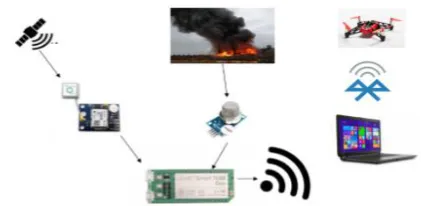
We built a complete system consisting of IoT platforms, sensors, and drone to locate, identify, and track precarious swaggers in real time. Once located, drone transmits data about swagger boundaries so it can be tracked in real time including data points such as wind direction, speed, location, the chemical composition and density measured within the air. This enables ground-based responders to see a visual representation of the area occupied by the swagger in real time. Over time, this also enables immediate identification of high-risk areas that should be evacuated.
Figure 1 : An overview of the system with single Drone
data, drone dynamically adjusts its heading and
position based on current environmental
observations. This data is also transmitted over the wireless network to an on scene server, which stores the data for later analysis as well as displays the data in real time via browser as shown in figure 1.
III.EVALUATION METHODOLOGY
To evaluate our proposed framework we previously needed to recognize which parts to utilize. We begun by testing to distinguish which quad-copters and IoT stages to utilize. The assessment criteria we utilized included lift ability, strength, battery life, positional precision, and information correspondence trust worthiness. Our first challenge was to ensure our design did not exceed the lift capacity of the small drone. This turned out to be a key challenge that heavily influenced the design of the IoT platform we integrated. All components were tested individually as well as incrementally as we integrated components prior to full system testing to ensure that issues encountered during system evaluations could be easily identified and repaired.
This demonstrated essential given the incorporation of different segments on drone. This testing depends on three key zones: physical parameters (estimate matters), framework between operability and inertness, just as joining with drone's self-governing control framework.
A. IoT Platform and Drone Integration.
1) Drone: For this work, we used the Parrot Rolling Spider drone. This drone was selected for several reasons. First, its size and weight made it an ideal candidate for an indoor evaluation. The small form factor enabled use in confined areas, while its weight allowed for nimble movement without requiring bulky, high output motors. This improved the stability of our autonomous systems with minimal weight, however, the small form factor also limited
Before pairing drone with sensors and IoT board, we tested drone for mobility. Since our system does not require high speed maneuvering capabilities we ensured basic flights movements - lift, descent, forward, reverse, left, right, rotate right and rotate left. We then tested the battery life of drone under two scenarios: 1) motionless hovering and 2) minimum battery life with constant motion. We then identified drone’s lift capacity under different battery capacities; in other words, how much weight drone could carry while maintaining stable flight characteristics. Battery selection was also critical to power the IoT platform, sensors, and drone. Ideally, drone should remain in flight for as long as possible to track aerial swaggers, but this requires larger-capacity batteries. Given the small form factor drone we used in this prototype system, we had to strike a balance between weight and power capacity. We first characterized the power load of the drone as well as the IoT platform during flight. Based on the components data sheet, each IoT board draws between 200 - 300 milliampere (mA), the air quality sensors require 150 mA, and the GPS requires 45 mA for a total of 400 - 500 mA per drone. Using a battery load analyzer, we found that a lithium polymer (LiPo) 3.7-volt battery would last for over 20 minutes before needing to be recharged.
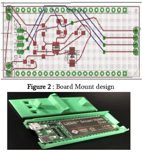
based on its ability to provide real time data with minimal latency as well as its small form factor. After an initial burn-in period of 10 hours, each air quality sensor was required to run for at minimum of one hour prior to testing to ensure accurate readings. Precarious air quality thresholds were identified by empirically testing the sensors with various gases and analyzing the results. As previously mentioned, we used a 250-milli ampere, 3.7 volt LiPo battery. We also integrated a GPS module and Node MCU that we connected to the IoT board via UART connection. We designed and developed a custom PCB, shown in figure 2, to combine all sensors with the IoT board that could be mounted on drone. We used the Eagle design tool for wiring schematics and built a two-layer board to include necessary components including the on-board step-up circuit to convert the 3.7 volt batteries to the 5 volts required for all components. To mount the IoT board, PCB, Node MCU and sensors on the drone, we used 3D modeling software and a 3D printer to create a custom case to use as a base mount as shown in figure 3. We mounted the base, with all components, to the drone by taking advantage of the wheel mounts to secure the platform.
Figure 2 : Board Mount design
Figure 3 : Board Mount Prototype
B. Arduino IDE Tool
Arduino IDE is Arduino integrated development environment or we can say it is Arduino software. It consists of a text editor, where the code is written. A message area is given, which shows message or any error message. The tool bar contains buttons for common features. The programs are uploaded to Arduino board by USB connection. This process is called code-uploading or code-burning.
C. Aerial Swagger Testing
To test our framework we expected to securely discharge airborne contaminants without affecting our wellbeing. Given our air quality sensor detects carbon monoxide (CO), we used cans of compressed air. And for Ammonia, we gently heated a mixture of ammonium chloride and calcium hydroxide in water. Collect the ammonia from the upward displacement of air in a hood. Each release of compressed air emits small quantities of CO, which is part of the propellant. We tested our integrated gas sensor and found we were able to detect the increase in CO from each release of air from the can. This enabled us to selectively release a new CO swagger during our experiments.
IV.RESULTS AND DISCUSSION
control system. Although we have collected results from a significant number of experiments, figure 4 depicts results after refining our control system from previous experiments.
Figure 4 : PCB Equipped with Sensors and Node MCU
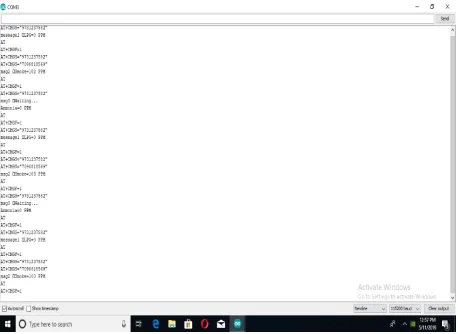
Figure 5 : Sensor Values displayed via Arduino IDE
Figure 6 : Sensor Readings
V. CONCLUSION
In this paper, we have described the precarious swagger identification and tracking system we built by combining NodeMCU and sensors on drone. Our results reveal that we are able to accurately identify and track contaminant swaggers over time to provide a visual indicator to on-scene first responders as well as collect data that can be used to validate and improve swagger movement models over time.
VI. REFERENCES
[1]. N. F. P. Association et al., NFPA 704, Standard System for the Identification of the Hazards of Materials for Emergency Response. National Fire Protection Association, 2017.
[2]. M. Pontiggia, M. Derudi, M. Alba, M. Scaioni, and R. Rota, “Precarious gas releases in urban areas: Assessment of consequences through cfd modelling,” Journal of Precarious Materials, vol. 176, no. 1, pp. 589–596, 2010.
[3]. R. R. Murphy, J. Peschel, C. Arnett, and D. Martin, “Projected needs for robot-assisted chemical, biological, radiological, or nuclear (cbrn) incidents,” in Safety, Security, and
Rescue Robotics (SSRR), 2012 IEEE
International Symposium on. IEEE, 2012, pp. 1–4.
[4]. A. Birk, B. Wiggerich, H. Bulow, M.
Pfingsthorn, and ¨ S. Schwertfeger, “Safety, security, and rescue missions with an unmanned aerial vehicle (uav),” Journal of Intelligent & Robotic Systems, vol. 64, no. 1, pp. 57–76, 2011.
[5]. N. Gerhardt, R. Clothier, and G. Wild, “Investigating the practicality of precarious material detection using unmanned aerial
systems,” in Metrology for Aerospace
[6]. E. D. McCormack and T. Trepanier, “The use of small unmanned aircraft by the washington
state department of transportation,”
Washington State Department of
Transportation, Tech. Rep., 2008.
[7]. P. Vincent and I. Rubin, “A framework and analysis for cooperative search using uav drone” in Proceedings of the 2004 ACM symposium on Applied computing. ACM, 2004, pp. 79–86. [8]. T. Kersnovski, F. Gonzalez, and K. Morton, “A
uav system for autonomous target detection and gas sensing,” in Aerospace Conference, 2017 IEEE. IEEE, 2017, pp. 1–12.
[9]. H. Menouar, I. Guvenc, K. Akkaya, A. S. Uluagac, A. Kadri, and A. Tuncer, “Uav-enabled intelligent transportation systems for the smart city: Applications and challenges,” IEEE Communications Magazine, vol. 55, no. 3, pp. 22–28, 2017.
[10]. T. Mac Thi, C. Copot, T. T. Duc, and R. De Keyser, “Ar. drone uav control parameters tuning based on particle drone optimization algorithm,” in IEEE International Conference on Automation, Quality and Testing, Robotics (AQTR), 2016, pp. 475–480.
[11]. F. Mochammad, A. R. Putra, and B. R. Trilaksono, “Implementation of precarious
chemical gas monitoring system using
unmanned aerial vehicle (uav),” in Frontiers of
Information Technology (FIT), 2016
International Conference on. IEEE, 2016, pp. 163–168.
[12]. L. Shi, X. Wang, T. Zhang, C. Hu, K. Luo, and B. Bai, “Precarious gas detection four-rotor uav system development,” in Mechatronics and Automation (ICMA), 2016 IEEE International Conference on. IEEE, 2016, pp. 2461–2465.
Cite this article as :
Nagaraj Telkar, Pavankumar Naik, Shrikanta Jogar, Pratibha Hulagur, Smeeta Policepatil, Sushma Giraddi, Vanaja Koppad, "Tracking Precarious Aerial Swaggers using IoT-Enabled Drone", International Journal of Scientific Research in Computer Science,
Engineering and Information Technology
(IJSRCSEIT), ISSN : 2456-3307, Volume 5 Issue 3, pp. 68-73, May-June 2019. Available at doi : https://doi.org/10.32628/CSEIT195330