CHAPTER ONE:
INTRODUCTIONThe objective of this research is to investigate, through a morphological study of eleven
mainline railway terminus areas in central London, the spatial conditions in which
they can be converted successfully from transportation nodes into urban places. In
practical terms, the research seeks a model through which railway terminus areas can
redevelop their physical and spatial structures, designed as regional-to-local
transport nodes, to function also as local pedestrian nodes, thereby creating urban
settings with a vibrant mix of pedestrian activity relating both to their immediate
urban contexts as well as to their regional transport destinations. The research aims
to benefit planners and designers, through the better understanding of how railway
termini and their surroundings interact in order to ensure the success of railway
terminus area redevelopment projects in cities.
1.1 STATEMENT OF THE PROBLEM
The major transformation of railway termini, including both system electrification in
the early 20th century1 and station modernisation2 towards the end of that same
century, has added much complexity and ambiguity to their internal spaces and related
structures. Although railway termini are no longer venerated as '...volcanoes of life,
...the finest churches in the world, ...palaces of the modern industry or ...cathedrals of
a new humankind '3 as they were in their early years, most continue to have important
roles as major transport interchanges in cities.
The end of the 20th century was a turning point in the history of railways in Europe.
Rail transport was rediscovered as an alternative to the congested road system and
connected to other transport infrastructures to optimise people's choices of travel on
1 The electrification of railways took place since the early 20th century until after World War II when steam engines were
completely replaced by electric and diesel engines. Without soot, smoke and steam, the system allowed cleaner stations and lines that can be sited in tunnels. The positioning of tracks in a cutting between tunnels also allowed more
complicated use of levels to simplify circulation (Sheppard, 1996 ).
2 As few large stations have been built since the 1920 when the rail network was fully in place, railway termini have
since required only redevelopment and renovation. The major modernisation occurred during the 1980s and aimed not only to restore the dilapidated railway stations but also to increase revenues for their operators by accommodating more commercial spaces. Cross circulation, raised level concourses and air rights above rail lines were the predominant approaches. Examples are Liverpool Street, Charing Cross, and Euston Stations in London (Sheppard, 1996 ).
3 These enthusiastic comparisons were made by writers such as Malevich, Cendras, Gautier in All Station, published by
local, regional and intercontinental scales. Furthermore, this has occurred within the
context of complex factors including the promotion of sustainable transport and land
use, the stimulation of local economies, the progress on railway technologies especially
the high speed train network (HST), the property market cycle and the impact of
globalization that has encouraged major cities to compete among themselves to maintain
their economic status as global cities4. Major railway termini have become hubs of the
network due to their strategic locations in cities, and the quasi-urban spaces of their
interiors, which increasingly serve various non-transport related functions such as
retail shops, cafes, restaurants, supermarkets, clinics or even libraries and spas,
packed within a multi-layered environment. Furthermore, station environs are also the
focus of numerous urban restructuring initiatives as blighted station neighbourhoods
and disused railway lands, associated with 'disurbanity' within such strategic sites in
the heart of cities, offer unrealised profits for the railway operators.
Despite such great awareness of both problems and opportunities, planners often
consider the station development process as a daunting task due to its complexity.
Luca Bertolini and Tejo Spit, researchers at the Department of Applied Geography and
Planning at the University of Utretch, who have carried out a study on planning and
management strategies of major railway station area redevelopment projects in Europe5,
noted in their 1998 book, Cities on Rails, The Redevelopment of Railway Station Areas6,
the difficulty of such projects. Due to the long development period, different locations
in cities, various involved working parties (architects, urban designers, planners,
property developers, local representatives, railway operators, etc.), and different
functions required for each station location, they argued that the projects are often
considered a challenge for planners, mostly resulting in conflicts of interests among
parties, rather than creating the intended order from chaos. They suggested that the
solution requires a multi-focal, long-term process viewed from several urban planning
and management perspectives.
4 See Bertolini and Spit, 1998 for more details on the factors driving the return of the railway age.
5 The projects include Euralille in France, Utretch Centrum Project and the Zuidas in the Netherlands, Stockholm City West in Sweden, Basel Euro Ville and Zentrum Zurich Nord in Switzerland and King's Cross railway lands in UK.
6 The book is so far the only textbook about the urban regeneration at railway station areas with a focus on European
cases. However, the authors have previously done several studies based on other global cases. The publications include; Bertolini, L. (1996a). Knots in the net, On the redevelopment of railway stations and their surroundings. In City, 1,1/2,129-137, Bertolini, L. (1996b). Nodes and Places: Complexities of Railway Station Redevelopment. In European
However, their study touches upon the practical notion of the spatial-functional
context of railway station locations only tangentially. Neither does it provide
empirical verification of how the successful projects are defined in terms of urban
spatial design, which may also be the crucial procedure in securing successful urban
regeneration along with key management, financial and policy instruments.
So far there has been very little specific research about railway-related urban projects
focusing on a tractable design process. Although planners have set up varied guiding
principles to benefit the appointed design teams for the refurbishment of railway
stations and the redevelopment of their surroundings, they have failed to introduce the
quantitative linkage between the suggested guidelines and their effects on space use.
Banister (1995) discussed, in general terms, transport-related urban development in
terms of the regional scale economic impact that would occur at railway stations where
the increased amount of movement could influence the development of land uses in the
vicinity of stations, both at termini and with knock-on effects at stations down the
line. Edward (1997) noted some design principles; for example that the stations and
their surroundings should be well connected and designed with the efficiency and
safety concerns as paramount. Stuyven (1998) suggested that the redevelopment
process should aim to eliminate the urban incision caused by railway lines and that
the entire urban fabric '...up to a minimum of 1 km around the station [should be] a
favoured area for condensation of land uses' (Stuyven op.cit.:19 ). Other similar
guidelines have been established and shared among the planners of Japan Railways,
French National Railways, British Rail and Railtrack, Dutch Railways, Swiss Railways
and other railway operators around the world7. However, it was Bertolini and Spit (1998
) who best summarised the conceptual design framework for all railway station area
redevelopment projects, stating that the process primarily aims to create a railway
station as a node of the transportation network and a place in the city. Despite such
clear objectives, it seems that the physical and spatial development process remain an
ambiguous and vague procedure for all urban designers.
This ambiguity usually leads to the outcome that there is no clear spatial-design
explanation of how successful projects such as the Broadgate Complex at Liverpool
Street Station in London, and La Gare Montparnasse in Paris (Figure 1.1a-e ) were
transformed from blighted station areas to become both efficient transport nodes and
vibrant urban places where people, not only rail travelers or commuters, but also
urban dwellers, converge in the multi-use environment. These areas have become both
destinations and transitional spaces in their cities, a success similarly envisaged for
an ambitious project like the Station Quarter; Frankfurt 21 (Figure 1.1f ).
Similarly, there is no clear spatial-design perspective to explain why some high
profile station development projects like Euralille at Lille Flandre-Europe Station in
Lille or Waterloo Station in London (Figure 1.1g-i ) fail to achieve the same degree of
vitality benefiting their local surroundings as was expected. For both projects,
although high speed rail networks (the Eurostar service) has improved the
accessibility at these station locations and turned them into important regional and
international transport nodes in Europe, the stations and their environs are still
segregated from their local surroundings. The redevelopment cannot overcome the
urban incision caused by the entangled railway structures and are unable to revitalise
the local surroundings and their blighted condition. In addition to these large scale
unsuccessful developments, it also turns out that there has been no tractable process to
explain why small termini like London's Cannon Street and Charing Cross Stations do
not share the liveliness of their urban settings.
The principle vehicle to address this problem will be a series of studies of London's
eleven mainline railway terminus areas: King's Cross/St.Pancras, Liverpool Street,
Fenchurch Street, Cannon Street, London Bridge, Waterloo, Charing Cross, Victoria,
Paddington, Marylebone, and Euston Stations. London is unique in both having such a
large number of termini and in the variety of ways in which they are embedded in the
dense urban fabric in different locations (Figure 1.2 ). All of the termini date from
the last century and so also have a long history of affecting and being affected by their
urban contexts. It is also the case that several have been subjected to recent
redevelopment, often with a view to upgrading the quality of the terminus and its
surroundings, and not always with equal success.
According to the survey of current urban conditions at these terminus areas, which
includes a general overview of their land use and levels of pedestrian movement (see a
series of notes and photographs in Appendix A 8), all of them seem to have several
sub-areas attached to the terminus buildings, with distinctive urban conditions and
unequal degrees of vitality and blight. They all have various combinations of vibrant
areas, with high levels of pedestrian activity and mixed land use, quieter areas with
single land use, and blighted areas with deserted pedestrian environments.
Liverpool Street Station is the most vibrant terminus, with a double-level internal
space well-used by commuters, travellers, office workers, shoppers as well as urban
dwellers. The terminus is well-connected to the bustling Broadgate Complex: the newly
created office development with retail spaces and three well-used public squares built
over its approach tracks. The redevelopment commenced in the 1980s with its current
phase still ongoing. The terminus is also surrounded by areas with mixed land use of
offices, retail, commercial, hotels and several newly developed spaces in the station's
vicinity such as the Spitalfield's office / market complex, office and apartment
buildings. Although the area further down the tracks is still left undeveloped, and is
currently occupied by mixed old and new residences, it is home to a very lively
Bangladeshi community, the well-known street market of Brick Lane and the new goods
yard market being renovated under the railway viaduct spaces (Figure 1.3a-d ).
Charing Cross is very much busier than Cannon Street Station. Both are elevated
bridgehead railway termini located just beyond the river Thames' bank with rather
enclosed internal spaces segregated from their vibrant surroundings by the level
differences. Having a high level of pedestrian activity throughout the day, the area
around Charing Cross Station is occupied by a mixed land use of offices, hotels,
entertainment places, retail, commerce, residences, governmental institutions and
public parks (Figure 1.4a-d ). The area of Cannon Street Station is less vibrant by
comparison, predominantly filled with large-scale office buildings. Some of them,
especially those located at the front and sides of the terminus, have street-level retail
spaces. Their rear aspects along the Thames are restricted to riverside offices and
service facilities such as entrances, parking and storage, warehouses. Thus to a large
degree the area is used only by office workers during the morning, lunch and evening
hours and is almost vacant at other times of the day (Figure 1.5a-d ). The offices with
some retail development at these two termini - 25 Downgate Hill at Cannon Street
Station and Embankment Place at Charing Cross Station, both implemented during the
1980s - do not have very much physical impact on their urban surroundings as they
were constructed by using air-rights above the terminus structures.
The surroundings of Euston and Victoria Stations are a combination of busy front and
side areas with mixed activity and rather quiet rear residential areas. Euston is a
busy terminus with a mixed-use internal environment which recently included a
temporary exhibition space. However, it is hidden away from the main road to the front
behind a bus station, a park and an office complex developed during the 1970s. It has
a busy area beyond this, filled with offices, retail, commercial buildings, a university
and west sides include retail, small businesses and residential uses for the local Asian
communities. The areas at the back of Euston Station along both sides of the
approaching rail lines are rather quiet but shows no sign of blight, being largely
occupied by pleasant and well-kept residential properties, including terrace houses,
council flats and apartments, (Figure 1.6a-d ).
Victoria Station is another bustling terminus with a mixed use internal environment
and a vibrant front area filled with retail, commercial buildings, offices, hotels,
theatres and residential flats. The terminus has the new office and commercial
complex, Victoria Place, built over a part of both it and its tracks. However, as the new
development does not completely cross the railway embankment (as does the Broadgate
Complex at Liverpool Street Station ) it does not reconnect the neighbourhoods to either
side of the tracks. Due to a higher level from the adjacent streets, the complex can only
be entered through steps or ramps. The area at the back of Victoria Station is a
combination of well-kept terrace houses and slightly blighted council flats, especially
those adjacent to the existing train depots (Figure 1.7a-d ).
The surroundings of London Bridge, Fenchurch Street, and Waterloo Stations are
generally well-used with some small blighted and inaccessible pocket areas attached
along their approach railway lines at the rear. All three of them are elevated terminus
structures with enclosed and segregated internal spaces. London Bridge Station is a
terminus with a branch line station hidden behind offices, retail uses and railway
viaducts crossing over the Thames from Cannon Street Station. Its front area is densely
built up with small offices, businesses, retail, warehouses and, at weekends and early
mornings, Borough Market. The whole railway structure is elevated on viaducts; thus
the station can only be entered by large ramps from the front, a pedestrian bridge from
the side street, and escalators from one of its viaduct spaces. There are several routes
crossing under the viaducts whose spaces are otherwise fully utilised as a museum
space (The London Dungeon), retail, restaurants, cafés, warehouses, and garages, etc.
The north side, between the railway viaducts and the Thames, which used to be an area
occupied by old wharves and warehouses, has been largely redeveloped. Several
warehouses have been refurbished as offices, commercial and apartment spaces. The
area also includes the Great London Authority (GLA) headquarters building, recently
completed. The south side is a combination of hospital buildings (Guy's Hospital),
small businesses, art studios, and a quieter area of warehouses and residential flats.
There are some undeveloped pieces of land fenced off for private parking garages or left
vacant and blighted attached both to the north and south of the rear railway viaducts
Fenchurch Street Station is a small elevated terminus hidden among high and
medium-rise office buildings. As it is located in the City of London, the terminus is
surrounded by office buildings with ground floor retail units, cafés, and restaurants.
Some are incorporated into its railway viaducts, thus making them fully utilised, and
also helping to create a vibrant street level environment continuing to other buildings
located next to them. However, the area further down the tracks, where some parts of
the viaducts have been fenced off, is a combination of old and new housing estates and
blighted warehouses and parking lots (Figure 1.9a-d ).
Waterloo Station is bounded by heavily trafficked roads and junctions; thus its
immediate environment is rather hostile to pedestrians. At its front, pedestrians can
cross to the areas beyond only by a network of underground pathways. As an elevated
terminus, its front and east sides are bounded by ramps and driveways, while its west
side can be approached only through a pedestrian bridge or an underground tunnel.
The station's front is also hidden behind the railway viaducts carrying the trains from
Charing Cross towards London Bridge Station, with the intermediate stop of ‘Little
Waterloo’ (or Waterloo East Station as it is now more commonly known), a branch line
railway station connected to the Waterloo terminus by a pedestrian bridge. However,
the mixed retail, office, and residential area further north is well used by pedestrians.
The station's west frontage is hidden behind an office complex developed in the 1960s
and its surrounding is occupied by large scale office buildings (for example The Shell
Centre), the South Bank cultural centre, a hotel and an aquarium (formerly County
Hall). The area is largely occupied by single use buildings with very few ground level
urban activities. The vibrant parts associated with mixed-use activities are the newly
redeveloped Forum Magnum Square and Jubilee Gardens leading to a major tourist
attraction; the London Eye. The viaducts to Waterloo's rear are predominantly
bordered with council flats, and the area is moderately used. Most viaduct spaces are
blocked or turned into garages, parking, warehouses or small businesses which are all
in a dilapidated condition. The railway viaducts allow several routes to connect
between two sides of the railway tracks but some are fenced off from the streets and
associated with small pockets of waste areas (Figure 1.10a-d ).
Paddington, Marylebone, and King's Cross/St.Pancras are vibrant but rather enclosed
termini which have busy front areas but are surrounded by very blighted areas on the
other sides especially their rear. Being occupied by only some dilapidated building
structures, the blighted parts are mostly vacant and inaccessible and often attached by
All three station areas are also cut through by Grand Union Canal which reinforces the
interruption of pedestrian network even more. Paddington Station has recently been
refurbished and now its internal space accommodates the Heathrow Express, airport
check-in facilities and more commercial units. The terminus is hidden behind the
railway hotel, built as its front façade, and an office complex. Due to the terminus
being built at a lower level than its adjacent streets, its internal space, although
vibrant, is very little exposed to the outside. The front area of Paddington Station is
characterised by a mixed use of offices, retail, a hospital complex (St. Mary's Hospital
and School) and well-kept terraced houses. Paddington Basin, a large vacant railway
area and goods yard with very few accessible routes from its surroundings, lies to the
north of the terminus. The area is divided by Canal Basin with few crossing routes and
is bounded to its west and north sides by the railway lines and the motorway (the
Westway or A40). However, following the completion of the station's refurbishment,
the Paddington Basin area is currently being redeveloped, having been left as vacant
railway lands for a long period of time, with its first phase due for completion in 2002
(Figure 1.11a-d ).
Marylebone Station is a small terminus, its set back location almost unnoticed from
the busy Marylebone Road. Its vibrant interior is the result of a very recent
refurbishment. It now accommodates more commercial and catering spaces, which
makes it a popular destination for local people and office workers during lunchtime.
Its urban setting is a combination of retail, offices, hotels, and terrace houses to its
front side, and rather blighted housing estates and council flats at its back, which were
redeveloped in the 1950s on the site of former goods yards. An office development was
attached to the west side of the terminus in the 1980s' but did not utilise the air-right
above the railway lines. There are several more apartment buildings currently under
development in some vacant areas along both sides of the railway lines, but all turn
their back against the railway embankment. The pedestrian movement level in the area
is relatively moderate compared to the other bigger and busier termini, but is
extremely low in the residential neighbourhoods to the rear (Figure 1.12a-d ).
King's Cross Station has a more bustling internal environment than the high level
St.Pancras Station situated next to it. Although King's Cross and St.Pancras Stations
are located just off a main road, the front bustling area being occupied by offices, small
businesses, hotels, retail and several old and new housing estates, a large blighted
railway land area of approximately sixty acres that lies within the triangle of the
railway junction to the north of both termini creates a very large urban hole in the city
by an old rail depot, dilapidated warehouses, a workhouse hospital, gas-holding
structures, a small park, and Grand Union Canal, is notorious for drug dealing and
prostitution. The King's Cross area is dubbed one of the largest brownfield site in
Europe because of this vast undeveloped railway wasteland located in the inner city
area. Although some buildings are still in occasional use, the area is generally left
vacant most of the time. Having only a few accessible routes from its surroundings, the
area has a very low pedestrian movement level with a high level of illicit activities
being recorded (Figure 1.13a-d ).
After reviewing these distinctive urban conditions, characteristics and functional
components of all eleven London's railway terminus areas, it seems that each needs to
be addressed differently in order to fulfil their potential roles as idiosyncratic nodes
and places in the city. Some, such as Liverpool Street and Charing Cross Station's
surroundings are already vibrant areas, and should have their physical and spatial
properties maintained and evaluated to ensure the success not only of their own
further redevelopment phases but also other future projects. It is clear that individual
redevelopment processes should address the spatial-functional characteristic of each
station location, rather than relying upon a single overarching policy applied to all
cases. Most importantly, before the redevelopment is planned, the locational
characteristics of the railway terminus and its relationship to the city have to be well
understood, including the physical urban pattern, land use and other spatial
properties.
1.2 THE RESEARCH SCOPE
As described above, the thesis sets out to investigate the physical and spatial
characteristics of the urban setting of significant transport nodes that could also
function as vibrant urban places in the city. It also aims to provide an explanation,
through an analytical process, of why some particular nodes are more or less
successful as places than the others. 'Place' in this thesis is taken to mean an urban
setting with a vibrant mixed use environment related in part to the influence of the
urban grid configuration on movement (Hillier et al 1993, Hillier 1996a ). This definition
deliberately does not engage in a phenomenological discussion of the essence or
meaning of place, nor does it touch on the distinction between place and space. Its
objectives are more modest and practical, directed towards the pragmatic concerns of
relating the level of pedestrian movement found in and around the terminus, both
in the city. The understanding of ‘place’ is further refined by Hillier's concept of a
‘live centre’, where the urban grid is intensified and its effect on movement
subsequently influences the intensification of activities (Hillier, 2000 ).
The investigation is particularly concerned with assessing what spatial factors promote
good levels of 'natural movement' (Hillier et al, 1993 ) both in and around the terminus
buildings. The assessment of pedestrian space uses is based on direct observation and
the demographic data gathered by the station operators' own surveys. A series of
chronological figure and ground study of the terminus areas along with a historical
review of their urban evolution explain the long term interaction between the railway
structures and their urban physical surroundings. Space syntax methods, a set of
computer techniques developed at the Bartlett School of Architecture, University
College London, are used for analysing how the terminus structures spatially affect
their current urban settings, and how the terminus areas are spatially embedded in the
larger scale structure of the urban grid. No attempt is made to examine the psychology
and motivation of people who move to and through the terminus areas. The evidence
used is the objective properties of space through patterns of movement and land use.
The scope of this research covers an investigation of all London's mainline railway
termini and their urban surroundings except Blackfriars Station. This small
bridgehead terminus on the bank of the Thames has been excluded because its
approaching railway are almost unrelated to its urban setting, being immediately
carried away on viaducts across the river. The research focuses only on London's
railway termini, not ‘through stations’, as the first type are more important in terms of
architectural, urban and social significance and have more critical effect on the urban
grids than the latter. Located among the densely built up areas in the city centre,
railway termini are the end-of-line stations where all trains terminate, bringing a
great number of passengers, commuters and goods into and out of the city (Holland, 1971
). The through railway stations, following Holland’s definition, are where trains stop
just temporarily for embarking and alighting passengers or goods. Their locations are
also farther out of the inner urban areas in less densely built up sites compared with
the termini. Hence these through stations tend to draw and attract significantly less
movement and have a less complicated entanglement of transport infrastructures (see
Appendix B for more descriptions and illustrations of all railway station types).
Steven Parissien, a writer who wrote about the history of railway stations, noted that
railway termini always represent varied grand architectural styles, from the
revivalism or eclecticism of the classical to the modern style, and show an excellent
exquisite long span train-sheds (Parissien, 1997 ). At their heyday, when railways were
the only long haul means of travel, termini were the sole distributing points for all who
lived far away, and were the gateways of cities. Great termini accommodated diverse
public facilities such as retail and other commercial outlets, and became the centre of
local communities and destinations in their own right.
Although at present they no longer act as the city's main gateways due to the rise of car
and air travel, most now find themselves among the most pivotal sites in the city.
Paradoxically, while they are served by important thoroughfares they are also
entwined by that same transport infrastructure, a mesh of surface and underground
trains, as well as roads and highways that can interrupt their approaching pedestrian
routes. This spatial dilemma is more intensified at the railway termini than the other
types of station. Finally, this research does not include London's underground train
stations as their immediate rail networks do not have any physical impact on the
surface urban grids, emerging from below ground rarely within the central zone.
In defining the area of study as the ‘railway terminus area’, the research uses the
suggestion made by Bertolini and Spit (1998 ) that this area be within a walkable radius
of five hundred metres around the terminus building or approximately a ten-minute
walk. This boundary, however, may or may not include the area that has been affected
by the terminus structures, as the termini may have an influence far beyond their
surroundings. Conversely, it is also possible that the immediate surrounding may
show no sign of any relationship to the terminus. One reason is that most terminus
areas have been bisected by railway lines for a long period of time. As Alexander
(1965 ) argues, cities are always influenced by the overlapping systematic forces of
economics, politics, and culture. Therefore, these sub-areas, both around the terminus
buildings and the areas evolving independently beside the tracks, could also have been
influenced by other factors. Thus, in this research the area within ten-minute walking
distance around each London's terminus will first be defined then further refined for
specific cases by the topography of the urban street grid to include all that is
significant and to prevent the exclusion of areas within the same urban block.
Since the aim of this research is to look at the relationship between urban grids and
patterns of pedestrian movement in London terminus areas, architectural elements and
proportions such as the relationship between floor area and the heights and functional
elements of buildings will not be analysed. Likewise, this study will not involve
aspects such as ownership, management or weather variables, although care was taken
conditions. Finally, no attempt will be made to understand or to explain the
socio-economic or political context of the terminus areas under investigation.
1.3 THE STRUCTURE OF THE ARGUMENT AND THE THEORETICAL FRAMEWORK
The main argument this thesis proposes is that the successful process of converting a
railway terminus area into a place is related to its spatial context and, therefore, that
the process must take into account the spatial configuration of both internal and
external spaces of the terminus building and how they are embedded in the city. This
means that successful outcomes depend on how well the spaces of the terminus are
integrated into the local system of pedestrian movement and the degree to which the
surrounding urban grids satisfy the spatial conditions that enable this to happen.
In making this argument, the thesis draws on the theory and earlier empirical results
of the Space Syntax research programme in studying the relation between the
configuration of the urban grid and pedestrian movement in cities and the powerful
relationship that has been established between both factors and the growth of local
centres. The key aspects derive from Bill Hillier's theories of natural movement and
movement economy and to a lesser extent, theory of centrality as a process.
Hillier's idea of the vibrant urban place depends on natural movement, which is how
the configuration of the urban grid facilitates movement from all parts to all others in
an urban area, where attractors and generators of movement are homogeneously
diffused throughout the system, making some parts vibrant and some parts quiet (Hillier
et al, 1993 ). The pattern of natural movement, thus determined by the urban grid,
subsequently influences land use patterns by attracting movement-seeking uses, such
as retail to locations of high natural movement while drawing non-movement seeking
uses, such as residential uses, to locations with low natural movement.
Hillier called this the process of movement economy. The movement attractors then
attract more movement to the high natural movement locations which in turn draws
further movement-seeking uses, creating multiplier effects which result in an urban
pattern with dense mixed use areas set against other more homogeneous, mainly
Therefore, to enable this process of natural movement and movement economy to
develop in any local area critically depends on how well the local urban grid is
integrated into a large scale urban context in order to make the system of local
movement become a part of the global movement in the city.
In turn, this process can be magnified in the circumstance that the intensification of
movement economy process also occurs in an area of a locally intensified grid structure
creating 'local syntactic integration'. This occurs in areas having smaller and more
regular urban blocks, a spatial condition that minimises 'metric integration' or real
distance and mean trip lengths from all points to all others in the local area. In such a
circumstance the area will become a 'configurational attractor' whereby pedestrian
movement and activity are both concentrated and multiplied by these reinforcing
effects occurring both within the area itself and its immediate surroundings. Hillier
has argued that this intensified grid characteristic is always found in live centres of
towns and cities and has called this the process of centrality (Hillier, 2000 ).
The thesis takes its starting point by making three propositions based on these ideas.
The first proposition is that there are three characteristics of railway termini that
distort and disrupt the process of natural movement in the urban settings in which
they are embedded, thus make the areas become blighted. Firstly, while the urban
place in Hillier's idea is a configurational attractor; attracting movement by the
influence of the local grid and subsequently affecting the development of land use from
the multiplier effect process, a railway terminus is, on the contrary, a point attractor;
attracting and generating a large amount of movement toward its entrances regardless
of the grid configuration. A high level of movement in the station's immediate
surroundings might be noted only during the station's peak hours, reducing
dramatically at other times of the day, without being sustained in the same way as
areas where movement is influenced by the grid configuration.
Secondly, the movement inside the terminus is not from all parts to all others but much
more deterministic, between the station's entrances and platforms. This type of
movement belongs to passengers who use the station to board trains or interchange with
other modes of transport. Being the centre of transport node, the terminus building
whose internal space is enclosed and segregated from its surrounding grid network
would also be cut off from or even obstruct the natural movement system itself. It
means that the terminus can attract only transport passengers, mostly toward its front,
with high levels of passenger during its peak periods, but its single-use internal
environment could be left almost vacant at other times of the day.
Thirdly, a railway terminus can be a negative attractor. While an attractor is an urban
entity that attracts movement so that its presence can usually be detected in increasing
movement rates on certain alignments as the attractor is approached, a negative
attractor deters movement away from it. It describes how railway lines and their
related structures such as train sheds, goods depots, and railway lands disable the
natural movement system by acting as an urban barrier to the rear of the terminus and
preventing people from reaching their destinations at the other side of the tracks.
Hence movement tends to decrease as the railway areas are approached and this
disruption of natural movement subsequently undermines the movement economy
process. As a result, the area to the rear of the terminus is unable to attract further
land uses, while the existing ones are left blighted and vacant because there is no
to-and-through movement in the area.
Here we find the paradox in Bertolini and Spit's node-place idea. The perspective
outlined above means the concept of node and place in fact causes a spatial dilemma in
the terminus area because, while to be an efficient transport node requires a good
connection of transport infrastructures resulting in the entanglement of urban
barriers that severely disconnect the pedestrian grid network, this disrupts the
potential for natural movement, the primary factor in the process of forming vibrant
urban places.
Furthermore, the node-place strategy is also a contradictory spatial process that leads
to a predicament in the development of railway station areas. Bertolini and Spit (1998 )
noted that the critical mass of transport networks attract particular land uses to
develop. However, in turn the increasing activities also necessitate increased
accessibility and traffic support, while the dense cluster of land uses can make it
difficult for the transport network to adjust and expand, and furthermore increasing
traffic may also decrease the urbanity of the area. Importantly, this points to the
effects that point and negative attractors , such as transport infrastructures at railway
stations, impose upon their surroundings both in terms of land use development and
the degree of vitality. However, it also crucially suggests that the solution to overcome
these problems comes through a process of spatial organisation that balances all
The second proposition of this thesis is that to transform the blighted transport
nodes into vibrant urban places is thus to revive the natural movement system by
integrating the terminus spaces into their local grid network so that they become a part
of the local movement system. This means creating the 'urban grid-related movement'
to complement the deterministic 'station-related movement' by promoting well
spatially embedded terminus buildings that are able to also draw the movement of
non-passengers, into their internal spaces. To allow this to happen, the stations'
surrounding grids must also be well integrated into the larger urban network. This
also means that the urban incision caused by the terminus structures and railway
lands should be eliminated in order to get rid of the negative attractor effects in the
areas. The well integrated pedestrian networks in the railway termini and their
surroundings can then function as both destinations and transitional spaces and
should attract both station users and urban dwellers to and from the areas as well as
generating pedestrian movement passing through the areas to all other destinations in
the city.
The well embedded railway termini can thus be seen as configurational attractors, in
addition to their nature as point attractors whereby the deterministic movement can
still be found in their concourse spaces. The transport nodes like railway termini that
fulfil these spatial properties would also become pedestrian nodes, well linked with
both to and through pedestrian movement networks. The well interconnecting urban
grids that weave through and around the termini would also enhance their movement
attractor effect, having a large number of pedestrians drawn and generated from all
around the buildings, not only at their front. Through the movement economy process,
the station areas altogether would potentially develop into configurational attractors
in a larger scale with high levels of grid-related as well as station-related movement
that would potentially draw more land uses, with subsequent multiplier effects leading
to the development of further land uses within the stations' surroundings through the
generation of increased amounts of movement. This would result in having the areas
both in and around the termini clustered with mixed activities and altogether became
vibrant urban places in their own right.
These spatial conditions lead to the final proposition of this thesis. The railway
terminus areas, having been spatially re-engineered to revive the natural movement
and subsequently stimulate the movement economy process, would potentially become
live centres in the city, in the terminology of Hillier. This is because the increased
amounts of movement, as being added up altogether by the natural movement and all
subsequently lead to the intensification of urban grids, as suggested by Siksna (1997)
in the recent studies of Australian and American cities, to allow greater ease of
movement within the areas. However, this spatially led and dynamic process of
centrality in any local urban area requires a long period of time to fully take shape,
and so such an evaluation is not fully possible in this thesis. A forecast, based only on
the spatial potentials of individual termini to become live centres will be offered at the
end of the study.
1.4 THE THESIS OUTLINE
In order to investigate which spatial properties lead to a high natural movement level
in and around London's railway termini, the thesis is organised as a comparative case
study of all eleven railway terminus areas in London based on the three propositions of
the research argument, and structured around seven chapters as follows:
This first Introduction Chapter states the problem and the theoretical framework
that lead to the formulation of the main thesis question and arguments. It starts by
introducing the subject and aims of the research before outlining why the node-place
problem in railway terminus area redevelopment exists through an overview of the
current urban conditions of all case studies. Important terminology related to the
thesis question is defined to limit the scope of the research study area. The thesis
arguments are then shaped on the basis of related theories. At the end of Chapter
One, how the thesis is structured according to its objectives and the contents of the
subsequent chapters are clarified.
Chapter Two clarifies and substantiates the problem definition. It begins with a
historical review of the changing role of railway stations in cities, focusing on the
redevelopment of nodes into places. This is followed by a review of some recent
projects in Europe where an attempt has been made to urbanize the termini. The
evolution of terminus areas and their development potential will then be summarised
using a conceptual and diagrammatic framework derived from node-place theory. The
objectives of this first part are to review what is necessary to turn a node into a place
and to establish a common ground for the node-place development framework of railway
terminus areas in urban practice design. In the second part, the work done by authors
who focus on the theoretical analysis of how the morphological relation between local
urban areas and the city relates to their successful performance as places will be
purports the spatial analysis of railway terminus areas, both at the architectural and
urban scales, and relevant works using the space syntax methodology are described.
The investigation of London's railway terminus areas begins with a study of their
internal dynamics. In Chapter Three , two selective London termini are examined in
terms of their internal spatial structures and patterns of use and movement. This
study aims to ascertain how far the very different spatial configurations of both
termini play a role in the deterministic movement patterns between their entrances
and platforms, as well as in many other kinds of activity that are increasingly
provided within termini at present. Different techniques of spatial analysis that have
successfully been used for large open spaces (as opposed to linear street spaces) will
be used experimentally along with empirical observations of static and moving
behaviours of the station users.
The next three chapters present a series of studies gradually building up to the
precision of urban morphological properties of eleven London's railway termini.
Starting from figure and ground studies, the analysis moves on to spatial
configurational analysis and the implications on space use patterns.
Chapter Four investigates how the terminus structures have affected and been
affected by the urban physical pattern of their surroundings since their first arrival
in the areas, up until the present time and how the evolving physical pattern relates to
the urban condition of each terminus area introduced in Chapter One. The chapter
begins by examining in detail the historical evolution of the terminus areas, both in
terms of their embedding in different sites in the city dictated by the decisions of
railway companies, and in terms of their different layouts necessitated by the existing
urban conditions. Firstly, the development sequence of the termini will be reviewed,
leading to the current situation in which they now exist as an ellipse bounding the
inner London area. Secondly, the evolution of the urban physical pattern of all eleven
terminus areas is examined through a series of figure-ground studies compared in
three periods; first, the existing pattern before the construction of the terminus
structures; second, toward the end of the 19th century after the period of urban
consolidation when the areas started to decline and finally, the present time. In cases
where the terminus area is currently being redeveloped, such as the Paddington Station
area, the prospective figure-ground pattern after the redevelopment is also analysed.
Chapter Five examines the spatial configuration of London terminus areas as they are
analysis. The study in this chapter is structured in three main parts. Firstly, the
study begins from the large spatial map of London and examines how each terminus is
embedded within the global and local spatial cores of the city. Secondly, the spatial
analysis focuses more on a local scale to investigate how the terminus structures,
including internal and external spaces, are embedded and affect their local spatial
grid network. These two types of axial representation are analysed graphically in
order to establish an intuitive grasp of the spatial structure of the study areas in two
different scales. Thirdly, the study turns to a numerical analysis, comparing the
degrees to which the station buildings spatially embed within their urban context. All
studies included in this chapter aim to identify the spatial relationship between
London termini and their larger urban spatial structure and to establish spatial
database of each terminus area to be examined in relation with the empirical data on
its functional use in Chapter Six. Through a comparative study, the chapter examines
to what extent London terminus areas share common morphological characteristics that
are related to the vibrant place as well as blighted urban conditions set out in the
introductory chapter. At the end of this chapter, the categorisation of all terminus
areas is established as a result of the comparative analysis.
Chapter Six covers a further analysis of space use in the railway terminus areas
focusing on the relationship between their spatial properties and pedestrian movement
data. The chapter is divided into two main sections to separately examine the
station-related and urban-grid related movement patterns within each station area.
First, this section investigates the effects of the termini as point and negative
attractors through a graphical presentation of day average movement levels,
empirically observed on some key routes around the terminus buildings during both
station's peak and non-peak periods. The second section analyses, through numerical
data, the relationship between the spatial configuration and movement rates in order to
trace out the natural movement level in all sub-areas around the terminus buildings.
According to the preceding categorisation of London's terminus areas, the findings of
both studies in this chapter add up in precise details in term of pedestrian space uses
in the areas.
Chapter Seven brings together all the findings of the previous chapters in a general
discussion. All eleven London's termini and their settings are reviewed in the light of
node-place conceptual framework based on the outcome of the research. The key point
of the review is the degree to which each London's terminus, a transport node, also
functions as a vibrant urban place. This summarisation is done through a statistical
internal space use data such as percentages of passengers and non-passengers, the
amount of retail and catering spaces. In other words, the review focuses on the degree
to which the terminus buildings attract other types of station user besides the
transport passengers relates to how well they spatially embed within the city. This
also enables an assessment of how the spatial embedding influences the development of
non-transport related functions such as retail and food facilities inside their
concourse spaces. The review will also further explore the spatial potential of the
unsuccessful or undeveloped terminus areas and make a suggestion of how to turn them
into places including the spatial potential of the already successful case to be further
developed into a 'live centre'. At the end of discussion, the chapter concludes by
assessing the physical and spatial characteristics that might relate to a series of
criteria for the successful creation of railway terminus areas, as significant transport
Marylebone
Paddington
Victoria
Charing Cross
Waterloo London Bridge
Liverpool Street
Fenchurch Street
Cannon Street King's Cross
St.Pancras
Euston
Blackfriars
from the Ordinance Survey Map, 1995 MAINLINE RAILWAY TERMINI
Figure 1.4: Charing Cross Station area
Figure 1.5: Cannon Street Station area
a b c d
a b c d
and is often used by pedestrians as a short cut between urban blocks. b: Exchange Square: the new public space was built above Liverpool Street Station's approach lines.
c: Brick Lane: a busy commercial street at the heart of a large Bangladeshi community.
d: The viaduct space is now intended to accommodate a 'Goods Yard Market' at weekends.
a: A railway hotel forms Charing Cross Station's front facade.
b: Villiers Street, a bustling retail strip at the east side of the terminus building, connects Strand Street at the station's front to Victoria Embankment at the back.
c: The railway viaducts have been refurbished as retail spaces. d: The Embankment Place office development was built over the terminus by using the air rights above the railway tracks.
a: The front facade of Cannon Street Sation.
The area is occupied by office, retail and small business uses.
b: The office development at 25 Downgate Hill, was built above the terminus structure. c: One of the railway viaduct spaces was turned to a motorcycle showroom.
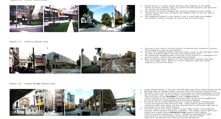
Figure 1.7: Victoria Station area
Figure 1.8: London Bridge Station area
c: Private houses were built alongside the railway tracks to the rear side of Euston Station.
d: The residential locates to the station's rear is a well kept and pleasant environment, mostly occupied .by council and terraced houses.
a: The area to the front of Victoria Station is bustling with travellers, tourists, office workers as well as local people.
b: Victoria Place Shopping Galleria was built above a part of the approach tracks. Its level is slightly higher than the surrounding street level.
c: The residential neighbourhood at the back of the station is a combination of terrace houses, council flats and apartment buildings.
d: Many residential blocks adjacent to the railway lands typically face away from the railway track. Many are in poor condition, especially those adjacent to the old rail depot.
a: London Bridge Station is set back from Borough High Street behind retail and office buildings and the railway viaduct carrying trains from Cannon Street Station. b: The west (front) side of the terminus is occupied by new developments of office and residential uses, most have been refurbished from old riverside warehouses. There are also a prison museum, the Clink and a wine centre, Vinopolis, which
attract tourists to the riverside during the week, as well as Borough Market, a local destination during weekday mornings and weekends.
c: The south side of London Bridge Station's viaducts along St.Thomas Street is very much quieter than the north side. Some viaduct spaces have been utilised as small retail shops but the attached land is still vacant and used as a parking lot for local office workers.
d: The north side of the railway viaducts along Tooley Street is bustling with tourists, office workers, travellers, shoppers. The viaduct spaces have been turned into a great tourist attraction, London Dungeon, and several retail spaces. There are several commercial / office / residential developments newly constructed in the area between Tooley Street and the Thames. Some were refurbished from existing riverside warehouses.
a b c d
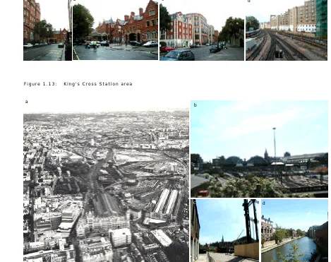
b Figure 1.13: King's Cross Station area
b: The terminus' front facade on Melcombe Place was restored in the 1980s. The area is very busy during peak hours but rather quiet at the other times of the day.
c: The development of office buildings in the 1980s was bounded by the station's west side.
d: There are several new residential blocks that have recently been constructed in the railway land adjacent to the railway tracks.
a
a: An arial view shows a large area of railway land of approximately 60 acres to the rear of King's Cross and St.Pancras Station.
(Source: Union Railways London & Continental / from Bertolini and Spit, 1998)
b-c: Besides the railway structures, the railway land is occupied by old warehouses, factories, gas holding structures and has only a few accessible routes from the surroundings. The area is unpopulated for most of the time, both weekdays and weekend, and become the location for illicit activities: drug dealing, prostitution, etc.
d: There is some new housing recently developed along the banks of Grand Union Canal at the edge of the railway land.
d
Figure 1.10: Waterloo Station area
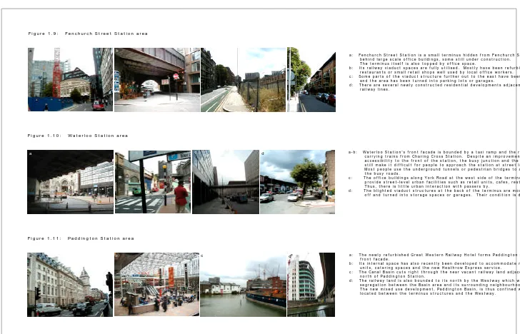
Figure 1.11: Paddington Station area
The terminus itself is also topped by office space.
b: Its railway viaduct spaces are fully utilised. Mostly have been refurbished as cafes, restaurants or small retail shops well used by local office workers.
c: Some parts of the viaduct structure further out to the east have been fenced off and the area has been turned into parking lots or garages.
d: There are several newly constructed residential developments adjacent to the railway lines.
a-b: Waterloo Station's front facade is bounded by a taxi ramp and the railway viaducts carrying trains from Charing Cross Station. Despite an improvement of pedestrian accessibility to the front of the station, the busy junction and the viaduct structure still make it difficult for people to approach the station at street level.
Most people use the underground tunnels or pedestrian bridges to avoid crossing the busy roads.
c: The office buildings along York Road at the west side of the terminus do not provide street-level urban facilities such as retail units, cafes, restaurants, etc. Thus, there is little urban interaction with passers by.
d: The blighted viaduct structures at the back of the terminus are mostly blocked off and turned into storage spaces or garages. Their condition is dilapidated.
a: The newly refurbished Great Western Railway Hotel forms Paddington Station's front facade.
b: Its internal space has also recently been developed to accommodate more retail units, catering spaces and the new Heathrow Express service.
c: The Canal Basin cuts right through the near vacant railway land adjacent to the north of Paddington Station.
d: The railway land is also bounded to its north by the Westway which worsens the segregation between the Basin area and its surrounding neighbourhoods. The new mixed use development, Paddington Basin, is thus confined within the area located between the terminus structures and the Westway.
d a
b c
b d