Reedsport Addendum Page 1-1
City Addendum
City of Reedsport
Overview
The city of Reedsport developed this addendum to the Douglas County multi-jurisdictional Natural Hazards Mitigation Plan in an effort to increase the community’s resilience to natural hazards. The addendum focuses on the natural hazards that could affect Reedsport, Oregon, which include: coastal erosion, drought, earthquake, flood, landslide, tsunami, wildfire, windstorm, and winter storm.
It is impossible to predict exactly when disasters may occur, or the extent to which they will affect the city. However, with careful planning and collaboration among public agencies, private sector organizations, and citizens within the community, it is possible to minimize the losses that can result from natural hazards.
The addendum provides a set of actions that aim to reduce the risks posed by natural hazards through education and outreach programs, the
development of partnerships, and the implementation of preventative activities such as land use programs. The actions described in the addendum are intended to be implemented through existing plans and programs within the city when possible.
This addendum is comprised of the following sections: 1) Addendum Development Process; 2) Community Profile; 3) Risk Assessment; 4) Action Items; and 5) Plan Implementation and Maintenance.
Addendum Development Process
In the fall of 2007, the Oregon Partnership for Disaster Resilience (The Partnership/OPDR) at the University of Oregon’s Community Service Center partnered with Oregon Emergency Management (OEM) and Resource Assistance for Rural Environments (RARE) to develop a Pre-Disaster Mitigation planning grant proposal to create and/or update natural hazard mitigation plans for Oregon’s southern coastal cities, which include the city of Reedsport. RARE provided a staff person (‘RARE Participant’) to facilitate and document the cities’ planning processes. To develop the addendum, the RARE participant facilitated the planning process with a local steering committee. Representatives from the following organizations served as members of the steering committee:
• Reedsport Public Works Superintendant • Reedsport City Manager
Page 1-2 Reedsport Addendum
• Reedsport Police Chief
• Douglas County Emergency Manager • Reedsport Fire Chief
• Oregon Coast Community Action Representative
The steering committee was involved in developing the addendum by providing local hazard and vulnerability information. The planning process was developed by the Oregon Partnership for Disaster Resilience, and was designed to: (1) result in an addendum that is DMA 2000
compliant; (2) coordinate with the state’s plan and activities of the
Partnership; and (3) build a network of local organizations that can play an active role in plan implementation.
The following is a summary of major planning activities:
Phase 1: Getting Started. From October 2007 to January 2008, the RARE Participant established contacts with Reedsport staff, and assisted the city in identifying members to serve on the plan’s steering committee. With assistance from OPDR, the RARE Participant developed and facilitated a ‘Kick-off’ meeting on November 2nd, 2007, and introduced the steering
committee to the planning process. Additionally, the RARE Participant conducted interviews with important stakeholders in the Reedsport community, and began work on the city’s addendum.
As part of the regional Pre-Disaster Mitigation grant, The Partnership
implemented a region-wide household preparedness survey.i The survey
gauged household knowledge of mitigation tools and techniques and assessed household disaster preparedness. The survey results improve public/private coordination of mitigation and preparedness for natural hazards by obtaining more accurate information on household
understanding and needs.
Phase II: Risk Assessment. Phase II of the planning process focused on identifying and understanding the relationship between natural hazards, vulnerable systems within the community, and existing capabilities. To begin the risk assessment process, the RARE Participant reviewed existing research concerning the causes and characteristics of potential natural hazards, as well as their probabilities of occurrence and potential impacts. Resources included Oregon’s Technical Resource Guide, and reports produced by the Department of Geology and Mineral Industries
(DOGAMI) among others. Please see the Risk Assessment section below for hazard-specific resources and information.
On January 7th and March 11th, 2008, the RARE participant met with the
Reedsport steering committee to identify community assets and
vulnerabilities. These meetings identified areas in the community that were potentially vulnerable to natural hazards, and the location and extent of those hazards. This information was used to develop a comprehensive risk assessment for each of the natural hazards addressed in this plan which
Reedsport Addendum Page 1-3
will enable the city to identify and prioritize mitigation actions to reduce losses from identified hazards. The RARE participant developed and facilitated both meetings, which took place at the Reedsport City Hall. Phase III: Developing a Mitigation Strategy/Plan Implementation and Maintenance. From April 2008 to June 2008, the RARE participant developed action items based on the community risk assessments and contact with Reedsport city staff. On May 20, 2008, the RARE participant
facilitated an action item development meeting with the Reedsport steering committee to review the mitigation action items. The steering committee, in partnership with the RARE participant and Oregon Partnership for Disaster Resilience, reviewed the natural hazards facing Reedsport and developed new action items as necessary.
In addition to discussing the mitigation strategy, the steering committee discussed plan implementation and maintenance strategies.
Adoption
The Reedsport City Council will be responsible for adopting Reedsport’s addendum to the Douglas County Natural Hazards Mitigation Plan. This governing body has the authority to promote sound public policy
regarding natural hazards.
The city of Reedsport adopted its addendum to the Douglas County Natural Hazards Mitigation Plan via resolution on March 1, 2010.
Reedsport Addendum Page 1-5
Community Profile
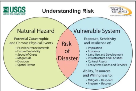
The following section describes the city of Reedsport from a number of perspectives in order to help define and understand the city’s sensitivity and resilience to natural hazards. Sensitivity factors can be defined as those community assets and characteristics that may be impacted by natural hazards, (e.g., special populations, economic factors, and historic and cultural resources). Community resilience factors can be defined as the community’s ability to manage risk and adapt to hazard event impacts (e.g., governmental structure, agency missions and directives, and plans, policies, and programs). The information in this section represents a snapshot in time of the current sensitivity and resilience factors in the city when the plan was developed. The information documented below, along with information from the risk assessment, should be used as the local level rationale for the city’s risk reduction actions. The identification of actions that reduce the city’s sensitivity and increase its resilience assist in reducing overall risk, or the area of overlap in Figure 1 below.
Figure 1 Understanding Risk
iiGeography & Climate
Reedsport is located in coastal Douglas County, in the Oregon Coast Region near the mouth of the Umpqua River on Oregon Highway 101. The community is approximately 194 miles south of Portland, Oregon, and 530 miles north of San Francisco, California. According to the 2000 U.S. Census, the community encompasses a total area of 2.29 square miles, including 0.24 square miles of water and 2.06 square miles of land.
Page 1-6 Reedsport Addendum
Average temperatures range from a monthly low of 37°F and an average monthly high of 69°F. The city of Reedsport receives an average annual precipitation of 76.010". iii
Population & Demographics
Reedsport was established on the estuary of the Umpqua River on January 7, 1852.iv The building of Southern Pacific Railroad lines extending south to
Coos Bay led to the development of Reedsport. Before the post office was established in 1912, Reedsport was a camp for railroad construction workers.
In 1990, the city of Reedsport was home to 4,796 permanent residents. According to the 2000 U.S. Census, there was about an 8% decrease in permanent residents to 4,378. Of those 4,378, 51.7% were female, and 48.3% were male.
The 2000 U.S. Census indicates that 80.3% of Reedsport’s population lived in family households. The racial composition in 2000 was 93.9% White, 1.2% American Indian and Alaska native, and 0.4% Asian. A total of 2.2% of the population identified with two or more races. Less than five percent (4.7%) of the population identified themselves as Hispanic or Latino. The impact in terms of loss and the ability to recover vary among population groups following a disaster. Historically, 80% of the disaster burden falls on the public.v Of this number, a disproportionate burden is
place upon special needs groups, including children, the elderly, the disabled, minorities, and low income persons. Portions of the city of
Reedsport’s residents fall into these special needs populations, as shown in Tables 1 and 2 below.
Table 1: Disabled Populations by Age Group, City of Reedsport, 2000
Age Percentage Disabled
5-15 years 9.1%
16-64 years 24.4%
65 years and older 40.5% Source: US Census, 2000
Table 2: Population by Age, City of Reedsport, 2000
Age Number Percentage
Under 5 210 4.8% 5 -19 years 801 18.2% 20-44 years 1,042 23.8% 45-64 years 1,180 26.9% 65+ years 1,145 26.2% Source: US Census, 2000
Employment and Economics
Historically, the economy of Reedsport has been largely based on fishing and timber. Both commercial fishing and timber have declined in the last few decades. The economy has transitioned to more tourism, services, and
Reedsport Addendum Page 1-7
retail. Table 3 below describes the industries and number of employees found in Reedsport. A majority of Reedsport’s employment is in the service industry which includes tourism, recreation, and government services. Reedsport is located in the Umpqua Port district and is included in tourism and sport fishing activities.
Median income can be used as an indicator of the strength of the region’s economic stability. In 1999, the median household income in Reedsport was $26,054. This is almost $15,000 below the 1999 national median
household income of $41,994, and almost $7,000 below the $33,223 median household income for Douglas County.vi Although it can be used to
compare areas as a whole, this number does not reflect how income is divided among area residents.
Table 3: Employment by Industry, City of Reedsport
Employment Industry Number Percentage
Educational, health and social
services 283 19.3
Arts, entertainment, recreation,
accommodation and food services 250 17.1
Retail trade 215 14.7
Construction 164 11.2
Professional, scientific, management, administrative, and waste
management services
114 7.8
Transportation and warehousing, and
utilities 96 6.6
Manufacturing 71 4.8
Agriculture, forestry, fishing and
hunting, and mining 65 4.4
Public administration 64 4.4 Other services (except public
administration) 54 3.7
Information 46 3.1
Finance, insurance, real estate, and
rental and leasing 28 1.9
Wholesale trade 14 1
Source: US Census, 2000
Housing
Housing type and year-built dates are important factors in mitigation planning. Certain housing types tend to be less disaster resistant and warrant special attention: mobile homes, for example, are generally more prone to wind and water damage than standard stick-built homes. Generally the older the home is, the greater the risk of damage from natural disasters. This is because stricter building codes have been
developed following improved scientific understanding of plate tectonics and earthquake risk. For example, structures build after the late 1960’s in
Page 1-8 Reedsport Addendum
the Northwest and California use earthquake resistant designs and construction techniques. In addition, FEMA began assisting communities with floodplain mapping during the 1970’s, and communities developed ordinances that required homes in the floodplain to be elevated to one foot above Base Flood Elevation.
In 2000, the city of Reedsport had 2,178 housing units. Of those, 66.9% (1,324) were owner occupied, 33.1% (654) were renter occupied, and about 10% (200 units) were vacant.vii Nearly 80% of the city’s housing stock was
built before 1980, when more advanced seismic building codes were implemented.
Table 4: Housing Type, City of Reedsport
Housing Type Number Percentage
1- Unit, Detached 1,319 60.3 1- Unit, Attached 52 2.4
Multifamily 458 21.0
Mobile Home 348 15.9
Boat, RV, Van, etc. 11 0.5 Source: US Census, 2000
Table 5: Housing Structure Age, City of Reedsport
Age Built Number Percentage
1999 to March 2000 15 0.7 1995 to 1998 73 3.3 1990 to 1994 100 4.6 1980 to 2000 283 12.9 1970 to 1979 670 30.6 1960 to 1969 356 16.3 1940 to 1959 489 22.3 1939 or earlier 202 9.2 Source: US Census, 2000
Land Use & Development
Development in the city of Reedsport spreads mostly along Hwy 101 and 38; however, the city is divided southwest and northeast by Scholfield slough. A majority of the city services are located on the northeastern island divided by the Scholfield slough. Residential development is located along Highways 101 and 38.
The city is currently finalizing an urban renewal program, a majority of which is along Hwy 38. The city’s Comprehensive Plan identifies land use needs within the city and the Urban Growth Boundary. According to Reedsport’s Urban Renewal Plan, building permits in Reedsport have mirrored population trends, with only six new residential units permitted since 2000.
Transportation & Commuting Patterns
Two major transportation routes run through the city of Reedsport: Highway 101 and Oregon State Highway 38. Highway 101 runs north to
Reedsport Addendum Page 1-9
south over the Umpqua River and Scholfield Creek, and includes three bridges over the river. Oregon State Highway 38 runs west to east along the Umpqua River. Transportation routes can be seen below on page 9. The Central Oregon Pacific Rail Road has tracks that run through the city of Reedsport, but there is no commuter rail available to city residents. Amtrak and Greyhound do, however, run bus lines from Reedsport to Eugene.
Transportation is an important consideration when planning for emergency service provisions. Currently there is minimal population growth in Reedsport. Possible growth within the city will put pressure on both major and minor roads, especially since the main mode of travel is by single occupancy vehicles (see Table 6 below).
Table 6: Means of Transportation, City of Reedsport
Source: US Census, 2000
Means of Transportation Number Percent
Workers 16 and over 1,448 100
Car, truck, or van 1,229 84.9
Drove alone 1,093 75.5 Carpooled 136 9.4 Walked 135 9.3 Worked at home 52 3.6 Other means 32 2.2 Public transportation 0 0 Bicycle 0 0
36 35 2 1 35 34 3 2 34 33 4 3 3 4 9 10 27 28 33 34 22 21 28 27 23 22 27 26 24 23 26 25 25 26 35 36 26 27 34 35 2 3 10 11 1 2 11 12 33 4 UMPQUA HWY. HWY. HWY. OREGON COAST NO. 45 NO. 9 COAST NO. 9 OREGON R.R. PACIFIC CENTRAL PACIFIC R.R. OREGON CENTRAL PACIFIC OREGON R.R. MILE 10 MILE 11 MILE 12 MILE 0 MILE 1 RIVER Gardiner Reservoir McIntosh Scholfield Creek Creek Butler Creek SMITH RIVER Slough Silver Providence Creek Providence Creek MILE 2 Step Creek PLANT TREATMENT
Covered
Res. Cutoff The SWING BRIDGE SWING BRIDGE Steamboat Island (Cannery Bolon Blacks Island Island Island Leeds Mud Mud Mud Mud Mud Mud Mud Mud Mud Levee Levee Levee Levee Levee Island) Levee Levee Levee Mud Flat Tidal Mud & & & CENTRAL OREGON WASTE WATER PRELIMINARY COPY SUBJECT TO CORRECTION PUBLISHED BY 38 38 NHS NHS NHS NHS 101 101 101 NHS NHS Gardiner Gardiner East REEDSPORT M.P. 1.62 M.P. 211.11 M.P. 213.40 BOLON ISLAND TIDEWAYS CORRIDOR STATE SCENIC SIUSLAW NATIONAL FORESTSIUSLAW
NATIONALFOREST
Showing Functional Classification of Roads
OREGON TRANSPORTATION MAP
City of
REEDSPORT
DOUGLAS COUNTY
REEDSPORT
REEDSPORT - DOUGLAS COUNTY
T. 21-22 S. R. 12 W. W.M. R. 12 W.
R. 12 W.
T. 22 S. T. 21 S. T. 22 S. T. 21 S. TO ELKTON TO NORTH BEND TO FLORENCE 0 METERS 600 600 1200 0 175 350 175 FEET SCALE"This product is for informational purposes and may
not have been prepared for or be suitable for legal,
engineering, or surveying purposes. Users of this
information should review or consult the primary data
and information sources to ascertain the usability
of the information."
AVAILABLE TRANSPORTATION SERVICES
SHOWN WITH YELLOW BACKGROUND
AVAILABLE TRANSPORTATION SERVICES
SHOWN WITH YELLOW BACKGROUND
PORT COMM. AIR
AMTRAK
PARK & RIDE INTERBUS AIRPORT
LEGEND
PARK & RIDE LOCATION
PUBLIC BUILDING CITY HALL ARMORY POST OFFICE SCHOOL LIBRARY WEIGH STATION SAFETY REST AREA
INTERCITY - CITY TRANSIT
AMTRAK STOP - PORT FACILITY
COMMERCIAL - GENERAL AVIATION
GRAVEL PIT - QUARRY - ODOT STOCKPILE SITE
COURTHOUSE INTERSTATE MINOR COLLECTOR FUNCTIONAL CLASSIFICATION STATE OTHER
ORE. ROUTE - US. ROUTE - INTERSTATE ROUTE FOR FURTHER FUNCTIONAL CLASSIFICATION INFORMATION, CONTACT O.D.O.T. REGION OFFICE.
PRINCIPAL ARTERIAL
MINOR ARTERIAL
LOCAL ROAD
URBAN COLLECTOR / RURAL MAJOR COLLECTOR
CITY LIMIT
URBAN GROWTH BOUNDARY
AMTRAK RAIL PASSENGER STATION NATIONAL HIGHWAY SYSTEM ROUTE
GRADE SEPARATIONS :
STATE - OTHER FUNCTIONALLY CLASSED - LOCAL ROAD
BRIDGE
IN COOPERATION WITH THE OREGON DEPARTMENT OF TRANSPORTATION
U.S. DEPARTMENT OF TRANSPORTATION
FEDERAL HIGHWAY ADMINISTRATION
PREPARED DIGITALLY BY THE TRAN SP OR TA TI O N O R E G O N D E P AR T ME N T O F I NFORMATION SE RV I C E S GE OG RA PH IC NORTH 2007 Population 4,305 *
Copies available from the Oregon Department of Transportation, Map Distribution Unit, Mill Creek Office Park, 555 13th St. NE, Suite 2, Salem, Oregon 97301-4178, Telephone (503) 986-3154, http://egov.oregon.gov/ODOT/TD/TDATA/gis/CityMaps.shtml * Based on current Oregon Population Report, College of Urban and Public Affairs, Portland State University, http://pdx.edu/prc
HAWTHORNE GREENWOOD FIR ELM DOGWOOD CEDAR BIRCH ALDER ARTHUR DR. AVE. AVE. AVE. AVE. AVE. IVY AVE. HAWTHORNE AVE. 16TH 14TH 13TH ST. ST. 18TH 19TH 20TH 21ST 22ND ST.
SCOTT TERR. SCOTT
CT. VISTA GARDENS AVE. HIGH ST. ST. ST. ST. ST. WINCHESTER HWY. AVE. FOREST RD. HILLS S. HILL DR. AVE. VIEW JUNIPER IVY AVE. ST. AVE. AVE. JUNIPER FIR AVE. AVE. AVE. AVE. AVE. LAUREL MYRTLE MILL 7TH ST. 11TH ST. ST. 12TH 10TH 9TH ST. ST. AVE. WINCHESTER SCHOLFIELD DR. GREENWOOD AVE. AVE. RAINBOW PLAZA WATER ST. CRESTVIEW N. HILLS CT. ELM AVE. RD. AVE. RAILROAD RAILROAD E. W. AVE. 7TH 6TH 5TH 4TH ST. ST. ST. ST. 3RD 2ND ST. UMPQUA AVE. STABLES RD. LOWER SMITH RIVER RD. HIGH ST. ST. SPRING COMMERCIAL JEWETT ST. LN. 1ST ST. FRONT ST. HAWTHORNE DR. HOLLY CT. DECKER POINT RD. AVE. AVE. AVE. ALDER W. PL. ALDER E. PL. PARK CT. RD. FRONTAGE CT. DR. WY. COUNTRY PROVIDENCE RD. RD. BOWMAN LONGWOOD ST. ST. ST. YORK DOYLE ROWE DR. BELLEVUE MAPLE DR. MORRISPL. RIDGEWAY ST. WARD PL. CLUB DR. CT. WESTMONT DR. RIDGEWAY CT. ASHWOOD CT. BITTERSWEET CT. BAYBERRYCT. CT. HEATHER GOLDENRODCT. DR. EVERGREEN HIGHLANDDR. MAPLE CT. VIEW CT. LONGWOOD DR. RANCH RD. RANCH RANCH FERN CT. DR. WY. RIVERFRONT REGENTS COUNTRY CLUB RD. RIVERBEND PORT DOCKCT. CHINOOK LN. CT. FERNWOOD PL. WEIGMAN LN. (PVT.) (PVT.) (PVT.) (PVT.) (PVT.) (PVT.) (PVT.) (PVT.) (PVT.) (PVT.) (PVT.) (PVT.) (PVT.) (PVT.) LIONS PARK REEDSPORT SCHOOL SHOPS OFFICES CITY SHOPS CHAMPION PARK N.F.S. RANGER STATION BOAT RAMP O.D.O.T. MAINT. STA. HENDERSON PARK BOAT RAMP PARK HIGHLAND SCHOOL HIGHLAND BICENTENNIAL PARK LOWER UMPQUA HOSPITAL FOREST HILLS COUNTRY CLUB
REEDSPORT
COUNTY COUNTY CEMETERY ELEM. W.F. JEWETT MIDDLE SCHOOL GARDINER CEMETERY BOAT RAMP E. RD. GARDINER DOCK PORT ST. 8TH AVE. FIR CRESTVIEW DR. FRONTAGE RD. GREENBRIAR PITT ST. FIRE HALL SUBSTATIONS POLICE\FIRE STATION (LOCATED LINE) HEMLOCK CT. WESTWOOD MOUND CAMELLIA CT. DR. CT. SWAIN (PVT.) ST. (PVT.) LASKEY RD. HIGH JR.\SR. ST.Reedsport Addendum Page 1-13
Critical Facilities & Infrastructure
Critical facilities are those that support government and first responders’ ability to take action in an emergency. They are a top priority in any comprehensive hazard mitigation plan. The city of Reedsport has two fire stations, one hospital, one elementary school, one junior/senior high school, a police department, a water treatment facility, and a waste water treatment facility.
The local hospital, Lower Umpqua Hospital and Nursing Home, provides 24-hour ambulance service. The city also has various health clinics,
primary care physicians, surgeons, dentists, pharmacies, eye clinics, and veterinary clinics. Other hospitals nearby include Peace Harbor in Florence (22 miles) and Bay Area Hospital in Coos Bay (25 miles).
Historic & Cultural Resources
Historic and cultural resources such as historic structures and landmarks can help to define a community’s identity and may also be sources of tourism dollars. Because of their role in defining and supporting the community, protecting these resources from the impact of disasters is important. The following structures and recreation areas are considered to be significant cultural and historic resources near the city of Reedsport:
• Umpqua River Light House built in 1856 • William M. Tugman State Park
• Umpqua Discovery Center • Bolon Island State Park
• Oregon Dunes National Recreation Area
Government Structure
The City Council is the policy making body for the city of Reedsport. The mayor and Councilors appoint the city manager, city attorney, and municipal judge.
The city of Reedsport has the following departments.viii
• City Manager: Directs and coordinates administration of the city
government in accordance with policies and directives of the City Council.
• Public Works: Development and maintenance of City infrastructure
• City Attorney: Representation and legal advice to the City Council
and staff
• Municipal Court Judge: Violation of city ordinances occurring within
the city limits or city owned property
• Umpqua Discovery Center Director: Directs educational outreach for
the Discovery Center - including tsunami and earthquake educational opportunities.
Page 1-14 Reedsport Addendum
• Fire Department: Being a part of the Emergency Response Team.
Informed and prepared to handle hazardous waste emergency. Protecting safety and welfare of persons and property.
• Police Department: Responsible for Emergency Response Team in
the event of a natural disaster. Protecting, training, enhancing the lives of the citizens.
• Finance Department: Dispatching information to utility crews.
Emergency outage telephone answering service. Maintenance of utility bills.
• Planning Department: Enforcing zoning ordinances, working with
general public to plan and monitor development activities.
Existing Plans & Policies
Communities often have existing plans and policies that guide and influence land use, land development, and population growth. Such existing plans and policies can include comprehensive plans, zoning ordinances, and technical reports or studies. Plans and policies already in existence have support from local residents, businesses and policy makers. Many land-use, comprehensive, and strategic plans get updated regularly, and can adapt easily to changing conditions and needs.
The city of Reedsport’s Addendum includes action items that, when
implemented, will reduce the city’s vulnerability to natural hazards. Many of these recommendations are consistent with the goals and objectives of the city’s existing plans and policies. Implementing the addendum’s action items through existing plans and policies increases their likelihood of being supported and getting updated, and maximizes the city’s resources.
Reedsport’s existing plans and policies include:
Comprehensive Plan – Reedsport’s Comprehensive Plan is a coordinated land use map and policy statement for the community that guides future planning decisions. The plan was created 1984 and revised 1990. The plan was periodically reviewed in 2007.
Reedsport Zoning Ordinance. The Zoning Ordinance contains regulations for the zoning of land within the city that have been adopted to promote and protect the public health, safety, and general welfare. The following sections address natural hazards in Reedsport:
• Section 4.010 Flood Hazard Area Purpose: To promote the public
health, safety and general welfare, and to minimize public and private losses due to flood conditions in specific areas by provisions designed.
• Section 4.140 Steep Slope Hazards The purpose of this Steep Slope
Hazard Section is to protect the public health, safety and welfare by ensuring that development in hazardous or potentially hazardous
Reedsport Addendum Page 1-15
areas is appropriately planned to minimize the threat to life and property.
Urban Renewal Plan – July, 2007 : The Urban Renewal Plan identifies improvements to the streetscape and utilities, and redevelopment of under-utilized properties and new businesses. The adequate provision of utilities to the entire district will assure that the quality of ground water is preserved, sanitary waste is properly treated and storm water is managed in a manner that enhances downstream water quality.
Transportation System Plan – February, 2006: The Reedsport
Transportation System Plan (TSP) identifies projects and programs needed to support the city’s goals and policies and to serve planned growth over the next 20 years, and will be incorporated (by reference) into the
Reedsport Comprehensive Plan. This document presents the investments and priorities for the pedestrian, bicycle, and motor vehicle systems along with new transportation programs to correct existing shortfalls and enhance critical services.
Social Systems
Social systems can be defined as community organizations and programs that provide social and community-based services, such as health care or housing assistance, to the public. In planning for natural hazard
mitigation, it is important to know what social systems exist within the community because of their existing connections to the public. Often, actions identified by the plan involve communication with the public or specific subgroups within the population (e.g. elderly, children, low income). Reedsport can use existing social systems as resources for
implementing such communication-related activities because these service providers already work directly with the public on a number of issues, one of which could be natural hazard preparedness and mitigation.
The following organizations are active within Douglas County and may be potential partners for implementing mitigation actions in the city of
Reedsport.
• American Red Cross Oregon Pacific Chapter • Reedsport/Winchester Bay Chamber of Commerce • Coastal Arts & Business Alliance
• Douglas County Extension Service
• Douglas County Health and Social Services • Eagle’s Hall
• Habitat for Humanity – Umpqua Valley • Lower Umpqua Senior Center
• Port of Umpqua
• Reedsport’s Family Resource Center • Siuslaw Outreach Services
• Timber Ridge Retirement Center • Great Afternoons
Page 1-16 Reedsport Addendum
• Lower Umpqua Ministerial Association
Existing Mitigation Activities
Existing mitigation activities include current mitigation programs and activities that are being implemented by the community in an effort to reduce the community’s overall risk to natural hazards. Documenting these efforts can assist participating jurisdictions better understand risk and can assist in documenting successes. The following mitigation projects have been implemented within the city of Reedsport:
Earthquakes:
• New buildings are built in accordance with the state of Oregon’s Seismic Zone 4 requirements. The seismic capacity of Reedsport’s building stock will improve over time as the existing stock is gradually replaced and/or upgraded.
• Education and outreach at Discovery Center regarding 8.0m+ earthquake.
Flooding:
• Adopted FEMA floodplain maps, 1984
• A $10.3 million project that is being funded by a revolving loan from the Oregon Department of Environmental quality will improve the city’s treatment plant and wastewater collection system. The project will improve wastewater flows and decrease sewer overflow during heavy rain or flooding events.
• Annual dike inspections are conducted by the Army Corps of Engineers to ensure that Reedsport’s levee system, which protects the downtown area from floods, are structurally sound.
Landslides:
• Code requires geotechnical reports for steep slope areas. Tsunami:
• Education and outreach: Pamphlets on basic guidelines for
encountering natural disasters; tsunami evacuation maps; tsunami zone warning. The evacuation zone on this map was developed by local officials in consultation with the Department of Geology and Mineral Industries and Oregon Emergency Management. It is intended to represent a worst-case scenario for a tsunami caused by an undersea earthquake near the Oregon coast. Evacuation routes were developed by local officials and reviewed by Oregon
Emergency Management. The Douglas County Sheriff's Office Emergency Management Division is publishing this brochure because the information furthers public awareness of the potential tsunami threat. The map is intended for emergency response and should not be used for site-specific planning.ix
Reedsport Addendum Page 1-17 Wildfire:
• Fire Department conducts education and outreach during fire season (fall).
Reedsport Addendum Page 1-19
Risk Assessment
The Douglas County Natural Hazards Mitigation Plan addresses the following natural hazards within its plan: earthquakes, floods, landslides, tsunamis, wildfires, windstorms, severe winter storms. The city of
Reedsport reviewed the county’s risk assessment, and assessed how Reedsport’s risks vary from the risks facing the entire county.
Additionally, Reedsport assessed its risk to drought hazards, which are not addressed in the Douglas County Plan.
The probability and vulnerability assessments included in the following risk assessments are derived from the Douglas County Coastal Hazard Analysis completed in February 2008. The Coastal Hazard Analysis can be found in Appendix A of Douglas County’s Natural Hazards Mitigation Plan.
Drought
Drought can be defined in several ways. The American Heritage Dictionary defines drought as "a long period with no rain, especially during a planting season." Another definition of drought is a deficiency in surface and sub-surface water supplies. In socioeconomic terms, drought occurs when a physical water shortage begins to affect people, individually and collectively, and the area’s economy.
Drought is typically measured in terms of water availability in a defined geographical area. It is common to express drought with a numerical index that ranks severity. The Oregon Drought Severity Index is the most
commonly used drought measurement in the state because it incorporates both local conditions and mountain snow pack. The Oregon Drought Severity Index categorizes droughts as mild, moderate, severe, and
extreme. In Reedsport, and in most areas along the Oregon coast, drought is of little to no concern. Reedsport’s average annual rainfall totals 76.010" and there is no history of severe drought within the city. However, in the 1970’s there was a potential for a drought in Reedsport, but none occurred. Drought is averted as a result of the coast’s high rainfall from moist air masses moving onto land from the Pacific Ocean, especially during winter months. Reedsport’s steering committee believes that the city’s
probability of experiencing a drought is very ‘low,’ meaning one incident is not likely to occur more than once within a 75-100 year period.
Drought is frequently an "incremental" hazard, meaning the onset and end are often difficult to determine. Also, its effects may accumulate slowly over a considerable period of time and may linger for years after the termination of the event. Potential impacts vary among communities. The extent and location of drought can occur region-wide, and can affect all segments of a jurisdiction’s population, particularly those dependent on rainfall (e.g. agriculture, hydroelectric generation, recreation, etc.). Within Reedsport, potential impacts may include water rationing and decreases in tourism-related activities. The likelihood that this would occur, however,
Page 1-20 Reedsport Addendum
is very low. The city has adequate storage capabilities that would prevent a shortage from occurring and/or affecting its residents. When there was a potential for a drought to occur in the 1970’s, the resulting action was to move the water reservoir intake in Clear Lake from an 8ft to 26ft level. Thus, the city of Reedsport estimates that its vulnerability to a drought event would be ‘low,’ meaning less than 1% of the population would be affected by an event.
Earthquake
Douglas County’s Mitigation Plan adequately describes causes and
characteristics of earthquake hazards, as well as the location and extent of a potential Cascadia Subduction Zone (CSZ) event (see Section 5, Douglas County Natural Hazards Mitigation Plan). Reedsport’s proximity to the Oregon Coast makes it susceptible to CSZ earthquakes which are caused by the abrupt release of slowly accumulated stress between the North American Plate and the Juan de Fuca plate. The subduction zone stretches from British Columbia to Northern California and is located
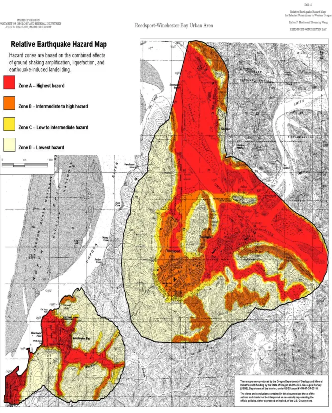
approximately 40 miles from the Oregon coast. A CSZ earthquake has the potential to produce a magnitude (M) 8 -9 earthquake, and the entire community of Reedsport would be significantly affected by such an event. The following earthquake hazard maps (Figures 2, 3, and 4) were
developed by the Oregon Department of Geology and Mineral Industries (DOGAMI). The figures identify locations within the city that are at risk to amplification, liquefaction, and earthquake induced landslides. As shown in the figures, Reedsport is at great risk to all three hazards. Liquefaction, in particular, is a great concern to Reedsport because the downtown area is built mostly on infill.
Figure 2: Relative Amplification Hazard Map
Figure 3: Relative Liquefaction Hazard Map
Figure 4: Relative Earthquake Hazard Map
Reedsport Addendum Page 1-27
The Douglas County Multi-Jurisdictional Natural Hazard Mitigation Plan adequately identifies the previous occurrences of earthquakes for the city of Reedsport. It is difficult to estimate recurrence intervals from available data. Paleoseismic studies along the Oregon coast indicate that the state has experienced seven Cascadia Subduction Zone (CSZ) events possibly as large as M9 in the last 3,500 years. These events are estimated to have an average recurrence interval between 500 and 600 years, although the time interval between individual events ranges from 150 to 1000 years. Scientists estimate the probability in the next 50 years of a great subduction zone earthquake is between 10 and 20 percent, assuming that the recurrence is on the order of 400 ± 200 years.x The last CSZ event occurred
approximately 300 years ago.
The Douglas County Coastal Hazard Analysis ranked the county’s vulnerability to earthquakes as high, meaning more than 10% of the population or region assets would be affected by a major event. This rating is representative of Reedsport’s vulnerability as well. Potential
community-specific impacts were identified by the Reedsport steering committee on March 11, 2008 and include the following:
• Water pumps and dikes along the north side of the Scholfield Creek prevent flooding in Reedsport’s downtown area. An M8-9 CSZ event may damage the pumps and dikes.
• Critical facilities including the Police Station, City Hall, and City Social Services are all located in the downtown area. Because the downtown is built on fill, the entire area is subject to liquefaction and severe damages in the event of a high magnitude earthquake. • Bridges in the area are potentially susceptible to
earthquake-induced damages. The Scholfield Bridge is a vital line between the west/east sides of Reedsport. Damage to this bridge could divide the two halves of the community. There are no other accessible roads.
• The levee system north of Scholfield Creek may be vulnerable to earthquakes. Breaches to the levee system would make the city vulnerable to floods and to tsunamis in an earthquake/tsunami event.
• The Hwy 101 Bridge over the Umpqua River crosses the estuary to the north side of the Smith River and the community of Gardiner. This provides Gardiner residents with access to Reedsport’s medical facilities.
• The waste water treatment plant is located downtown and in the 100-year floodplain. Although the wastewater treatment plant has been built to current seismic standards, an earthquake could potentially crack pipes.
Page 1-28 Reedsport Addendum
• From 2005-2007, under the direction of Oregon Senate Bill 2, DOGAMI completed a statewide seismic needs assessment that surveyed K-12 public school buildings, hospital buildings with acute inpatient care facilities, fire stations, police stations, sheriff’s offices and other law enforcement agency buildings. The needs assessment consisted of rapid visual screenings (RVS). RVS results were grouped into categories by risk of probable damage in a high magnitude earthquake. The following buildings within the city of Reedsport were at “high” risk of probable damage in a high magnitude event:
• Highland Elementary School • Reedsport Junior/High School • Lower Umpqua Hospital • Fire Station 1
• Reedsport Police Department
• Douglas County Sheriff’s Office (Reedsport)
Flood
The Douglas County Multi-Jurisdictional Natural Hazard Mitigation Plan adequately describes the location, extent, and history of flooding in the city of Reedsport (see Section 3: Flood, Douglas County Natural Hazard Mitigation Plan). The 2008 Douglas County Coastal Hazard Analysis ranked the county’s vulnerability to floods as moderate, meaning 1-10% of the population or region assets would be affected by a major emergency or event. Additionally, the Douglas County Coastal Hazard Analysis
estimates that the county’s probability of experiencing hazardous flood events along the coast is high, meaning at least one incident is likely within a 10 year period.xi Both ratings are also true for Reedsport.
A major flood occurred in Reedsport in December 1964 that was equal to a 100 year flood event. This flood inundated a major portion of the
downtown area. Water was 4 feet deep in most areas and led to the construction of the levee system around Reedsport’s downtown area.xii
Since the construction of the levees, Reedsport has been relatively free from major flooding events. Currently, however, culverts with tide gates in the levee are failing, and are in need of repair / replacement.
The FEMA Flood Insurance Rate Maps (FIRM) in Figures 5 and 6 below indicate the floodplain zones affected by the Umpqua River. The
downtown area is located in Zone B. Zone B is the FIRM map designation for properties being out of the 1% annual chance floodplain. Reedsport’s downtown area is located in Zone B because levees protect the area from regularly flooding. No Base Flood Elevations or depths are shown within this zone and insurance purchase is not required.xiii However, due to
Digital Flood Insurance Rate Maps (DFIRMS) being drawn, the city of Reedsport is required by FEMA to have the levee system certified. The city is therefore seeking certification services for the city’s dike system.
Reedsport Addendum Page 1-29
requirements of the Chief’s Economy Act in order to secure levee certification services from the U.S. Army Corps of Engineers.
Reedsport Addendum Page 1-33
The City of Reedsport has been a participating member in the National Flood Insurance Program (NFIP) since 1974. There are 74 FEMA National Flood Insurance Policies in Reedsport. There have been 3 total claims since 1978 reimbursing $151,400. The total coverage of these policies is
$12,540,100. There are 4 policies in Zone A, which means they are in areas with a 1% annual chance of flooding and a 26% chance of flooding over the life of a 30-year mortgage. The total premium is $28,594.xiv There are no
repetitive loss properties.
City staff identified the following potential community impacts or concerns about the flood hazard:
• The City Hall parking lot is inundated with inches of water every year. City Hall itself has not been flooded.
• The area known as River Bend Manufacture Home Park area is at risk from water system backup and Scholfield Slough high water level rise. The residential area consists of mostly seniors, a
vulnerable population during floods. The Park is privately owned. • Fir Avenue in the downtown and the City Hall parking lot are
inundated with inches of water every year.
• The intersection of 9th and Hawthorne floods due to catch basins
that can be blocked.
• Reedsport staff identified the Winchester storm drain and Elm Street Storm Water Station as areas with an increased risk. The Elm Street Pump station is particularly vulnerable due to lack of backup power supply.
• The potential failure of the dike system along the Scholfield Creek and Umpqua rivers could result in flooding beyond the FEMA FIRM levels. Continued maintenance of the city’s dike and levee system is required, including but not limited to, repair and
replacement of the gravity drains with tide gates and stop valves. As such, the city of Reedsport intends to partner with and seek funding from organizations such as the U.S. Army Corps of Engineers and others.
Landslide
The Douglas County Multi-Jurisdictional Natural Hazard Mitigation Plan adequately describes the causes, characteristics, and extent of landslides in the region. There are no records that identify the history of landslides for the city of Reedsport.
The Douglas County Coastal Hazard Analysis ranked the area’s vulnerability to landslide events as moderate, meaning 1-10% of the population or region assets would be affected by a major emergency or event. The Hazard Analysis also indicates that the area’s probability of
Page 1-34 Reedsport Addendum
experiencing landslides is high, meaning at least one incident is likely within a 10 year period.xv The steering committee stated these scores are
representative of Reedsport as well.
DOGAMI has identified the following locations (Figure 7 below) as prone to landslides in the aftermath of an earthquake. It can be assumed that these same areas may be prone to landslides due to other causes such as rain storms. Because this map is focused on earthquake induced
landslides, however, it may underestimate landslide hazards triggered by other events.
Figure 7: Relative Hazard Map of Earthquake-Induced Landslides
Reedsport Addendum Page 1-37
Although the city is located in the lowest level of landslide risk, there are potential impacts of surrounding landslides on the city. The impacts include potentially blocked highway access in and out of the city. Landslides can be created by natural conditions and processes including the geology of the site, rainfall, wave and water action, seismic tremors and earthquakes and volcanic activity.
Hwy 38, which connects Reedsport to the Willamette Valley, is highly vulnerable to landslides/erosion due to its steep slopes (Figure 7 above, seen in pink). If Highway 38 were to be closed due to a landslide, access to Interstate 5 would be limited, potentially disrupting transportation of commercial goods and other services. Closure of Highway 38 could also disrupt medical services and prevent evacuation out of Reedsport.
Tsunami
The Douglas County Multi-Jurisdictional Natural Hazard Mitigation Plan adequately describes the causes, characteristics, and extent of tsunamis in the region. Tsunamis, commonly called seismic sea waves – or incorrectly, tidal waves – have been responsible for at least 470 fatalities and several hundred million dollars in property damage in the United States and its territories. A tsunami is a series of sea waves usually caused by a rapid vertical movement along a break in the Earth’s crust (i.e., their origin is tectonic). A tsunami is generated when a large mass of earth on the bottom of the ocean drops or rises, thereby displacing the column of water directly above it.
Tsunamis along the Oregon coast can potentially occur from a
displacement along eastward-moving Juan de Fuca tectonic plate as it drives under the westward-moving North American Plate. This area is called the Cascadia Subduction Zone and is found just off the Oregon coast. Powerful earthquakes of up to magnitude 7.0 or greater can take place on either the North American or Juan de Fuca Plates. The Cascadia Subduction Zone, however, is capable of generating much larger
earthquakes – up to and above a magnitude 9, thousands of times stronger than a magnitude 7. In the past century, several damaging tsunamis have struck the Pacific Northwest coast from northern California to Washington. These distant tsunamis were generated from earthquakes located far across the Pacific basin and are distinguished from tsunamis generated by
earthquakes near the coast – termed local tsunamis.
Reedsport’s location upriver from the Oregon coast makes it susceptible to tsunamis. However, because the city is located several miles inland and not directly on the coast, a tsunami would have a similar impact as a localized flood. Some predictions show that a major subduction zone earthquake of magnitude 8.8 would produce a 20 to 30 meter tsunami at the mouth of the Umpqua River.xvi The amountof flooding expected in the city is unknown.
However, the steering committee indicated it would be similar to a severe localized flooding event. Localized flooding is mitigated by pumps and dike levees maintained by the Public Works department. As the
Page 1-38 Reedsport Addendum
earthquake section indicated, however, these systems may be
compromised following a Cascadia Subduction event. Partnering with the state of Oregon and Oregon Emergency Management to seek funding for assessment of and retrofit of critical infrastructure and educational facilities is essential.
The Douglas County Multi-Jurisdictional Natural Hazard Mitigation Plan – Coastal Hazard Analysis adequately identifies the history of tsunamis for the city of Reedsport (see Section 6: Tsunami, Douglas County Natural Hazard Mitigation Plan). The Douglas County Coastal Hazard Analysis ranked its vulnerability to tsunamis as moderate, meaning 1-10% of the population or region assets would be affected by a major emergency or event.
It is difficult to predict the probability of when the next tsunami will occur. Oregon has experienced 10 tsunamis in the last 135 years with only 3
causing measurable damage. It is estimated that all Cascadia tsunamis would cause extensive damage, and the last Cascadia Subduction Zone event occurred about 300 years ago.xvii Geologists predict a 10-14% chance
that a Cascadia tsunami will be triggered by a shallow, undersea
earthquake offshore Oregon in the next 50 years. The forecast comes from evidence for large but infrequent earthquakes and tsunamis that have occurred at the Oregon coast every 500 years, on average.xviii
The United States Department of Geological Survey (USGS) produced a tsunami map for the city of Reedsport; however, due to the city’s inland location, the tsunami inundation line does not reach the city’s boundaries (see Figure 8 below). There is no history of a tsunami resulting in localized flooding.
Figure 8. USGS Tsunami Map of Reedsport
Reedsport Addendum Page 1-41
Wildfire
The Douglas County Multi-Jurisdictional Natural Hazard Mitigation Plan adequately describes the causes and characteristics of a wildfire event, as well as the history of wildfire within the region (see Section 8: Wildfire, in the Douglas County Natural Hazard Mitigation Plan). Additionally, the county’s plan generally describes the location and extent of potential wildfire events. In Reedsport, extensive tracts of forested areas border the city to the south and east, but Reedsport has no history of any previous wildfire events. Indirect impacts may include ash fall and smoke that can affect the city depending on wind conditions. There is potential every year for a fire depending on the weather conditions such as hot and dry
summers with high winds.
The Douglas County Coastal Hazard Analysis ranked the vulnerability of wildfires as high, meaning greater than 10% of the population or regional assets would be affected by a major emergency or event. Reedsport agrees with this ranking. The Coastal Hazard Analysis also estimates that the coast’s probability of experiencing a wildfire event is high, meaning at least one incident is likely within a 10 year period.xix Due to the lack of
previous wildfire events within Reedsport, however, the steering committee estimates a ‘low’ probability that wildfires will occur in the future.
Wind and Winter Storms
The Douglas County Multi-Jurisdictional Natural Hazard Mitigation Plan adequately describes the causes and characteristics of windstorms as well as the history of windstorms in the area (see Section 7: Windstorm, Douglas County Natural Hazard Mitigation Plan). The Douglas County Coastal Hazard Analysis ranked the vulnerability of windstorms as moderate, meaning 1-10% of the population or regional assets would be affected by a major emergency or event. The county also estimates that its probability of experiencing windstorms is high, meaning at least one incident is likely within a 10 year period. These rankings are
representative of Reedsport as well.
Windstorms come every year and impact the entire city. Douglas County’s Plan adequately describes the types of impacts that are felt by Reedsport, including damages to tree, branches, and roofs. Hazardous conditions caused by strong winds have the potential to disrupt transportation routes and down power lines as well. The Douglas County mitigation plan also adequately describes the location and extent of the windstorm hazard in Reedsport.
Windstorms are most common from October to March. Due to Reedsport’s location at sea level and adjacent to the Pacific Ocean, significant snow accumulation is much less than on the eastside of the Cascades. However, Reedsport had 5.0 inches of snow during the 1950’s snow storm.xx Ice
Page 1-42 Reedsport Addendum
changes can result in varying types of ice formation which may include freezing rain, sleet and hail. Of these, freezing rain can be the most damaging of ice formations. The Reedsport Steering Committee indicted Highways 101 and 38 are affected by ice and can disrupt transportation in and out of the city.
Reedsport Addendum Page 1-43
Mitigation Plan Goals
The plan goals help guide the direction of future activities aimed at
reducing risk and preventing loss from natural hazards. The goals serve as checkpoints as agencies and organizations begin implementing mitigation action items. Reedsport will adopt the following Douglas County Natural Hazard Mitigation Plan goals:
Flood Mitigation Goals
Goal A: Protect structures in the floodplain from flooding.
Goal B: If a structure becomes a repetitive loss structure, inform owner of
possible mitigation funding options.
Goal C: If a structure becomes a repetitive loss structure, and a cost
benefit analysis reveals the repetitive loss has a substantial cost, encourage owner to use mitigation funding options.
Winter Storm Mitigation Goals
Goal A: Protect structures from winter storm damage.
Goal B: Maintain road system circulation capacity.
Goal C: Prevent utility damage from falling trees.
Goal D: Prevent falling trees from becoming a fire hazard.
Earthquake Mitigation Goals
Goal A: Prevent loss of life from earthquakes.
Goal B: Reduce property damages.
Goal C: Enhance education and public awareness of earthquake danger.
Goal D: Increase preparedness of communities and agencies to deal with
earthquakes.
Tsunami Mitigation Goals
Goal A: Protect lives of residents and visitors in tsunami prone areas.
Goal B: Reduce property damages and loss in tsunami prone areas.
Goal C: Enhance education and public awareness of tsunami dangers.
Goal D: Increase preparedness of communities and agencies to deal with
tsunami threat.
Wildfire Mitigation Goals
Goal A: Protect lives of residents and firefighters in wildfire hazard areas.
Goal B: Increase fire prevention/reduction activities and fire fighting
response abilities.
Goal C: Reduce property damages and loss in wildfire hazard areas.
Goal D: Enhance education of wildland/urban interface area property
owners and public awareness of wildfire dangers and prevention.
Goal E: Increase preparedness of communities and agencies to deal with
Page 1-44 Reedsport Addendum Windstorm Mitigation Goals
Goal A: Protect lives during windstorms.
Goal B: Reduce property damage resulting from windstorms.
Goal C: Enhance survivability of infrastructure and utilities during
windstorms.
Goal D: Enhance education and public awareness of windstorm dangers.
Goal E: Increase preparedness of communities and agencies.
Landslide Mitigation Goals
Goal A: Prevent loss of life from landslides.
Goal B: Reduce property damages.
Goal C: Enhance education and public awareness of landslide danger.
Goal D: Increase preparedness of communities and agencies to deal with
landslides.
Multi-Hazard Mitigation Goals 1. Protect life and property.
2. Develop partnerships and implementation strategies. 3. Public Awareness.
Reedsport Addendum Page 1-45
Action Items
The following action items are detailed recommendations for activities that local departments, citizens, and others could engage in to reduce risk. Each action identifies which of the county’s goals are addressed. Goals are identified within the actions as a means for monitoring and evaluating how well the mitigation plan is achieving its goals, following implementation. Please see full action item forms below for more information.
• Upgrade and expand the storm water infrastructure system to handle large amounts of water and potential flooding.
• Construct a pathway alongside the Scholfield dike system to provide emergency access.
• Upgrade storm water pumps and pump stations along Scholfield Creek to prevent future flooding.
• Consider alternatives to relocating critical and essential facilities out of the floodplain and potential tsunami inundation zone such as raising buildings above the base flood elevation or storing essential documents out of reach of floodwaters.
• Ensure continued compliance in the National Flood Insurance Program (NFIP) through enforcement of local floodplain management
ordinances.
• Seek certification for the city’s dike system.
• Seek funding for continued maintenance of the city’s dike and levee system, including but not limited to repair and replacement of the gravity drains with tide gates and stop valves.
• Assess critical and educational facilities rated medium and high potential of collapse by DOGAMI’s rapid visual assessment.
• Identify potential evacuation/supply routes in the event of a highway or bridge closure.
• Assess the Scholfield Bridge and adjoining water pipe for consideration for future retrofit.
46
Action Item (Flood)
Proposed Action Item: Alignment with FL Plan Goals:
Upgrade and expand the storm water infrastructure system to handle large amounts of water and potential flooding.
GOAL A: Protect structures in the floodplain from flooding. Rationale for Proposed Action Item:
The downtown area of Reedsport is frequently affected by heavy rains and winter storms. Reedsport’s storm water infrastructure is limited by the location and size of pipes and outdated infrastructure. The current system has difficulty managing the seasonal amount of water, causing backups and the potential for flooding every year.
There are several areas in Reedsport that are affected by a lack of storm water drainage:
• River Bend Manufactured Home Park is at risk from water system backup and Scholfield Slough
high water level rise. The residential area consists of mostly seniors, a vulnerable population during floods. The Park is privately owned.
• Fir Avenue in the downtown and the City Hall parking lot are inundated with inches of water
every year.
• The intersection of 9th and Hawthorne floods due to catch basins that can be blocked.
• Reedsport staff identified the Winchester storm drain and Elm Street Storm Water Station as areas
with an increased risk. The Elm Street Pump station is particularly vulnerable due to lack of backup power supply.
The Reedsport Addendum to the Douglas County Multi-Jurisdictional Natural Hazard Mitigation Plan ranked the City’s vulnerability to floods as moderate, meaning 1-10% of the population or region assets would be affected by a major emergency or event. Additionally, the City of Reedsport notes that its probability of experiencing hazardous flood events is high, meaning one incident is likely within a 10-35 year period. Upgrading the storm water infrastructure will help to reduce future incidences of flooding in Reedsport.
The Disaster Mitigation Act of 2000 requires communities to identify actions and projects that reduce the effects of hazards on both new and existing buildings and infrastructure [201.6(c)(3)(ii)]. Upgrading and expanding the storm water infrastructure system to handle large amounts of water will help reduce the risk of flooding and prevent damage to buildings and infrastructure in low-lying areas.
Ideas for Implementation:
Implement actions identified in the City’s Stormwater Master Plan (2002). Implement the 2009 Downtown Stormwater Reroute Analysis Plan.
Upgrade Elm St. Storm water station – need back up power supply, increase pipe size, increase pump motors.
Coordinating Organization: City of Reedsport Public Works
Internal Partners: External Partners:
City of Reedsport - Planning, Finance FEMA, OEM, Douglas County – Emergency Services
Timeline: If available, estimated cost:
Short Term (0-2 years) Long Term (2-4 or more years) $2,000,000 1-2 years
47
Action Item (Flood)
Proposed Action Item: Alignment with FL Plan Goals:
Construct a pathway alongside the Scholfield dike system to provide emergency access.
GOAL A: Protect structures in the floodplain from flooding.
Rationale for Proposed Action Item:
Enclosing Reedsport’s downtown area is an earthen levee system that protects the city’s downtown from flooding on the Umpqua River and Scholfield Creek. The dike is vital to protect the downtown area of Reedsport from flood and tsunami hazards. Access along the top of the dike is difficult due to the dike’s size and material, and a pathway along the dike would help provide better access to public works and other essential services to protect the levee from breaking in a flood.
The Disaster Mitigation Act of 2000 requires communities to identify actions and projects that reduce the effects of hazards on both new and existing buildings and infrastructure [201.6(c)(3)(ii)]. Constructing a pathway alongside the Scholfield dike system will help protect the dike from breaching in floods by providing faster emergency access to the dike. Protecting the dike will protect the buildings and infrastructure in low-lying downtown area in the community.
The potential failure of the dike system along the Scholfield Creek and Umpqua rivers could result in flooding beyond the FEMA FIRM levels.
Ideas for Implementation:
Complete structural engineering studies to establish options for upgrades.
Build an asphalt or gravel pathway alongside the dike to provide access to support services.
Seek funding from FEMA and/or the US Army Corps of Engineers to build a pathway alongside or on top of the Scholfield Dike system.
Coordinating Organization: City of Reedsport Public Works
Internal Partners: External Partners:
City of Reedsport: Planning, Finance, Parks, Fire Department
FEMA, OEM, US Army Corps of Engineers
Timeline: If available, estimated cost:
Short Term (0-2 years) Long Term (2-4 or more years) 2-4 years
Form Submitted by: Reedsport Steering Committee
48
Action Item (Flood)
Proposed Action Item: Alignment with FL Plan Goals:
Upgrade storm water pumps and pump stations along Scholfield Creek to prevent future flooding.
GOAL A: Protect structures in the floodplain from flooding.
Rationale for Proposed Action Item:
Storm water pumps and pump stations along Scholfield Creek, together with the earthen levees along the creek, are necessary to prevent water from flooding the downtown area. Upgrading storm water pumps and pump stations along Scholfield Creek will ensure that the downtown area, which is in the floodplain, will remain dry during flooding events.
Water pumps and dikes along the north side of the Scholfield Creek prevent flooding in Reedsport’s downtown area. An M8-9 CSZ event may damage the pumps and dikes.
River Bend Manufacture Home area is at risk from water system backup and Scholfield Slough high water level rise. The residential area consists of mostly seniors, a vulnerable population during floods
The Disaster Mitigation Act of 2000 requires communities to identify actions and projects that reduce the effects of hazards on both new and existing buildings and infrastructure [201.6(c)(3)(ii)]. Upgrading storm water pumps and pump stations along Scholfield Creek will reduce the vulnerability of flooding and prevent damage to buildings and infrastructure in the downtown area should flooding occur.
The potential failure of the dike system along the Scholfield Creek and Umpqua rivers could
result in flooding beyond the FEMA FIRM levels.
Ideas for Implementation:
Work with OEM to seek funding for upgrading storm water pumps and pump stations along Scholfield Creek.
Develop a storm water master plan for the City of Reedsport to study the need for upgrading storm water
pumps and pump stations along Scholfield Creek.
Coordinating Organization: City of Reedsport Public Works
Internal Partners: External Partners:
City of Reedsport: Planning, Finance State of Oregon Emergency Management
Douglas County Emergency Management
Timeline: If available, estimated cost:
Short Term (0-2 years) Long Term (2-4 or more years) 2-4 years
49
Action Item (Flood)
Proposed Action Item: Alignment with FL Plan Goals:
Consider alternatives to relocating critical and essential
facilities out of the floodplain and potential tsunami
inundation zone such as raising buildings above the base
flood elevation or storing essential documents out of reach
of floodwaters.
GOAL A: Protect structures in the floodplain from flooding.
Rationale for Proposed Action Item:
A number of critical facilities are located in Reedsport’s floodplain and tsunami inundation zone. These facilities include the police department and fire station. In addition, the City Hall, library, and public works department are also located in the floodplain and tsunami inundation zone and are vulnerable to natural hazard events. Raising these facilities or storing essential documents out of reach of floodwaters will reduce Reedsport’s vulnerability to flood and tsunami hazards.
The waste water treatment plant is located downtown and in the 100-year floodplain. Although the wastewater treatment plant has been built to current seismic standards, an earthquake could potentially crack pipes.
The Disaster Mitigation Act of 2000 requires communities to identify actions and projects that reduce the effects of hazards on both new and existing buildings and infrastructure [201.6(c)(3)(ii)]. Raising these facilities or storing essential documents out of reach of floodwaters will reduce Reedsport’s vulnerability to tsunami hazards, and will significantly reduce the impact of a flooding event in Reedsport.
Ideas for Implementation:
Seek funding to raise buildings above the base flood elevation and for storing essential documents out of
reach of floodwaters.
Coordinating Organization: City of Reedsport Planning
Internal Partners: External Partners:
City of Reedsport Fire Department, Police Department
State of Oregon Department of Land and Conservation
Development, FEMA, OEM,Douglas County –
Emergency Services
Timeline: If available, estimated cost:
Short Term (0-2 years) Long Term (2-4 or more years) Ongoing
50
Action Item (Flood)
Proposed Action Item: Alignment with FL Plan Goals:
Ensure continued compliance with the National Flood Insurance Program (NFIP) through enforcement of local floodplain management ordinances.
GOAL A: Protect structures in the floodplain from flooding.
Rationale for Proposed Action Item:
The National Flood Insurance Program (NFIP) provides communities with federally backed flood insurance, provided that communities develop and enforce adequate floodplain management measures. According to the NFIP, buildings constructed in compliance with NFIP building standards suffer approximately 80 percent less damage annually than those not built in compliance.
Reedsport is a participant in the National Flood Insurance Program since 1974, and the City has 74 policies in effect. Reedsport’s most recent Flood Insurance Rate Map is dated 1984. Everyone in a participating community of the National Flood Insurance Program (NFIP) can buy flood insurance. The Disaster Mitigation Act of 2000 requires that communities identify actions and projects that reduce the impact of a natural hazard on the community, particularly to new and existing buildings and
infrastructure [201.6(c)(3)(ii)]. Continued participation in the NFIP will diminish flood damage to new and existing buildings in communities while providing homeowners, renters, and business owners additional flood insurance protection.
Ideas for Implementation:
Actively participate with DLCD and FEMA during Community Assistance Visits. The Community Assisted Visit (CAV) is a scheduled visit to a community participating in the NFIP for the purpose of: 1) conducting a comprehensive assessment of the community’s floodplain management program; 2) assisting the community and its staff in understanding the NFIP and its requirements; and 3) assisting the
community in implementing effective flood loss reduction measures when program deficiencies or violations are discovered.
Conduct an assessment of Reedsport floodplain ordinances to ensure they reflect current flood hazards. Complete dike certification.
Continue to participate in the NFIP.
Educate residents in Reedsport about flood issues and actions they can implement to mitigate the flood risk.
Coordinating Organization: City of Reedsport Planning
Internal Partners: External Partners:
City of Reedsport – Public Works, Finance State of Oregon Department of Land and Conservation
Development , FEMA, OEM. Douglas County – Emergency Services
Timeline: If available, estimated cost:
Short Term (0-2 years) Long Term (2-4 or more years) Unavailable Ongoing