Real-time Dense Simultaneous
Localisation and Mapping over Large
Scale Environments
Thomas J. Whelan
A dissertation submitted for the degree of
Doctor of Philosophy
Department of Computer Science
Faculty of Science and Engineering
National University of Ireland Maynooth
August 2014
Head of Department: Dr. Adam Winstanley
Supervisor: Dr. John B. McDonald
Acknowledgements
Firstly I would like to express my enormous gratitude to my supervisor John McDonald for his insight, advice and support throughout this work. I could not have asked for a better supervisor who showed inspirational unwavering encouragement and enthusiasm over the past few years. I would also like to acknowledge the invaluable support and knowledge of my “grand supervisor” John Leonard. Between my time spent at CSAIL and the subsequent long term collaboration with his group he has played a key role in the success of my work and shaping my academic career as a whole.
I would also like to thank my examining committee, Prof. Ronan Reilly and Prof. Wolfram Burgard for their helpful comments and feedback on this thesis.
I was fortunate enough to become acquainted with a number of extremely talented individuals during my time spent at CSAIL. I would like to ex-press my special gratitude to Michael Kaess for his consistent expert ad-vice on a plethora of different topics throughout this research. In addition to this I would like to thank Hordur Johannsson and David Rosen for their insightful discussions on various different technical aspects of re-search. Special thanks also go to Ross Finman, Maurice Fallon and Mark VanMiddlesworth for their eagerness to collaborate and proficiency in do-ing so. I must also extend a warm thank you to the members of the VCA group at TU/e, in particular Lingni Ma, Egor Bondarev and Peter H. N.
fruitful collaboration for all parties involved.
Back in Maynooth there are a number of people in my own department I would like to thank for their support over the years including Adam Winstanley, Tom Lysaght and Guillaume Gales. Special thanks to Donagh Hatton for general computer science and life discussion over many well deserved breaks.
Research presented in this thesis was funded by a Strategic Research Cluster grant (07/SRC/I1168) by Science Foundation Ireland under the Irish National Development Plan and the Embark Initiative of the Irish Research Council. This funding is gratefully acknowledged.
Finally I would like to thank my parents for their unfaltering love and support throughout this whole endeavour. Their unmatched wisdom has guided me towards achieving everything I have so far in my life and ulti-mately realising my dreams. It was them who taught me the most valuable lessons I have ever learned, not in any lab or lecture theatre but in the loving environment of our family home.
Contents
Dedication ii
Acknowledgements iii
List of Figures ix
List of Tables xii
Abstract xiii 1 Introduction 1 1.1 Motivation . . . 1 1.2 Background . . . 5 1.3 Scope . . . 8 1.4 Publications . . . 10 1.5 Structure . . . 11 2 Visual Simultaneous Localisation and Mapping 13
2.2 Visual SLAM . . . 17
2.3 Dense Mapping . . . 18
2.4 Related Work . . . 19
3 Extended Scale Dense Mapping 27 3.1 Background . . . 27
3.2 Volume Representation . . . 29
3.3 Volume Shifting . . . 31
3.3.1 Implementation . . . 32
3.3.2 Surface Extraction . . . 33
3.4 Dynamic Cube Positioning . . . 36
3.5 Color Estimation . . . 38
3.5.1 Artifact Reduction . . . 39
3.6 Summary . . . 41
4 Robust Dense Visual Odometry 42 4.1 Geometric Camera Pose Estimation . . . 43
4.2 Photometric Camera Pose Estimation . . . 45
4.2.1 Preprocessing . . . 46
4.2.2 Precomputation . . . 46
4.2.3 Iterative Transformation Estimation . . . 48
4.3 Combined Camera Pose Estimate . . . 50
4.4 Summary . . . 51
5 Large Scale Dense Visual SLAM 52 5.1 Pose Graph . . . 54
5.2 Place Recognition . . . 54
5.2.1 SURF Correspondence Threshold . . . 56
CONTENTS
5.2.3 Point Cloud ICP . . . 57
5.3 Space Deformation . . . 57
5.3.1 Deformation Graph . . . 58
5.3.2 Incremental Graph Construction . . . 58
5.3.3 Incremental Vertex Weighting . . . 60
5.4 Optimisation . . . 62
5.4.1 Map Deformation . . . 62
5.5 Summary . . . 65
6 Map Simplification and Higher Level Representation 66 6.1 Building Blocks . . . 66
6.2 Computationally Efficient Architecture . . . 68
6.3 Planar Segmentation . . . 68
6.3.1 Curvature-Based Segmentation Algorithm . . . 69
6.4 Incremental Planar Segmentation . . . 71
6.4.1 Segment Growing . . . 71
6.5 Triangulation of Planar Segments . . . 75
6.5.1 QuadTree-Based Decimation . . . 75
6.5.2 Triangulation . . . 78
6.6 Texture Generation . . . 80
6.7 Summary . . . 82
7 Experimental Results 84 7.1 Dense Visual SLAM . . . 84
7.1.1 Trajectory Estimation . . . 85
7.1.2 Surface Reconstruction . . . 89
7.1.3 Computational Performance . . . 102
7.2.1 Incremental Segmentation Performance . . . 113 7.2.2 Triangulation Performance . . . 115 7.2.3 Computational Performance . . . 117 7.3 Multimedia . . . 121 8 Applications 124 8.1 Segmentation . . . 124
8.1.1 Object Segmentation From Change Detection . . . 125
8.1.2 Efficient Incremental Map Segmentation . . . 125
8.2 Closed-Loop Autonomous Robotic System . . . 127
8.2.1 Components . . . 128
8.2.2 Result . . . 135
9 Conclusions 137 9.1 Thesis Contributions . . . 137
List of Figures
1.1 Intel Research Lab dataset . . . 6
1.2 Stereo visual SLAM . . . 6
1.3 Dense map representation . . . 7
1.4 System architecture diagram . . . 9
3.1 Truncated signed distance function . . . 28
3.2 Volume shifting process . . . 30
3.3 Visualisation of the shifting process . . . 31
3.4 Cloud slice, camera pose and TSDF associations . . . 34
3.5 Shifted TSDF volume with cloud slices . . . 35
3.6 Dynamic cube positioning . . . 37
3.7 Color measurement weighting . . . 38
3.8 Color estimation results . . . 40
5.1 System architecture diagram . . . 53
5.2 Sequential deformation graph . . . 55
5.4 Comparison of connectivity strategies . . . 60
6.1 Parallel system architecture to process point clouds . . . 67
6.2 Incremental planar segmentation . . . 75
6.3 Comparison of triangulation methods . . . 76
6.4 Planar decimation and triangulation . . . 76
6.5 Vertex degree grid . . . 79
6.6 Example generated texture . . . 81
6.7 Implicit object information . . . 83
7.1 ATE RMSE in metres per sequence evaluated . . . 85
7.2 Two dimensional plot of estimated trajectories . . . 88
7.3 Heatmap comparison to 2-pass reconstruction . . . 95
7.4 Comparison of reconstructions on the fr1/xyz dataset . . . 96
7.5 Surface reconstruction comparison with DVO SLAM . . . 100
7.6 Mesh reconstruction of the first synthetic dataset . . . 101
7.7 Temporal histograms of predicted depth versus ground truth depth . 103 7.8 Surface ground truth evaluation datasets . . . 104
7.9 Camera trajectory plot within the Apartment dataset . . . 109
7.10 Dataset of a small coffee room . . . 109
7.11 Corridor loop closure dataset . . . 110
7.12 Large cluttered outdoor dataset . . . 110
7.13 Large outdoor dataset . . . 111
7.14 Dataset composed of two floors . . . 111
7.15 Large indoor and outdoor dataset . . . 112
7.16 Sequence over two floors of an apartment . . . 112
7.17 Incremental versus batch heatmaps . . . 114
LIST OF FIGURES
7.19 Incremental segmentation performance graph . . . 117
7.20 Incremental segmentation performance heatmap . . . 118
7.21 Joining of GPT mesh with planar segment triangulations . . . 121
7.22 Four evaluated plane datasets . . . 122
8.1 Two maps for alignment and differencing . . . 126
8.2 Incremental cloud slice segmentation . . . 127
8.3 The Turtlebot 2 platform . . . 129
8.4 Autonomous robotic system overview . . . 130
8.5 Area explored by the robot . . . 131
8.6 Planar simplification of explored area . . . 132
8.7 Object model and detected location . . . 133
8.8 Planned path from last robot location to object . . . 134
7.1 Statistics on ATE on evaluated datasets . . . 87
7.2 Comparison of ATE RMSE on evaluated datasets and SLAM systems 90 7.3 Comparison of ATE Median error on evaluated datasets . . . 90
7.4 Comparison of ATE Max error on evaluated datasets . . . 90
7.5 Statistics on seven handheld datasets with our approach . . . 94
7.6 Statistics on seven handheld datasets with DVO SLAM . . . 98
7.7 Computational performance of the volumetric fusion thread . . . 103
7.8 Computational performance on six datasets . . . 106
7.9 Computational performance on six datasets (subsampled) . . . 107
7.10 Computational performance on the Apartment dataset . . . 108
7.11 Computational performance on the Apartment dataset (subsampled) 108 7.12 Incremental versus batch planar segmentation statistics . . . 114
7.13 Planar point reduction comparison . . . 115
7.14 Planar mesh simplification comparison . . . 116
Abstract
The ability for a robot to create a map of an unknown environment and localise within that map is of critical importance in intelligent autonomous operation. This problem is referred to as Simultaneous Localisation and Mapping (or SLAM) and has been one of the major focusses of robotics research over the past 25 years. Although the initial focus was on 2D laser scan SLAM, more recently full 3D SLAM has become the dominant paradigm.
The recent expansion in popularity of full, dense 3D SLAM is arguably a result of the release of the Microsoft Kinect commodity RGB-D sensor, which provides high quality depth sensing capabilities for a little over one hundred US dollars. Before the advent of the Kinect, 3D SLAM methods required either time of flight (TOF) sensors, 3D lidar scanners or stereo vision, which were typically either quite expensive or not suitable for fully mobile real-time operation if dense reconstruction was desired. Another recent technology which is often coupled with dense methods is General-Purpose computing on Graphics Processing Units (GPGPU) which ex-ploits the massive parallelism available in GPU hardware to perform high speed and often real-time processing on entire images every frame. Being an affordable commodity technology, GPU-based programming is argu-ably another large enabler in recent dense SLAM research.
Many visual SLAM systems and 3D reconstruction systems (both offline and online) have been published in recent times that rely purely on RGB-D sensing capabilities because of the Kinect’s low price and accuracy; [43, 26, 113, 86]. However given the density of the data available, many existing systems have one or many limitations imposed by the challenges of processing such large amounts of information. These include a limitation in operating area, the inability to function in real-time over large scales, or not producing a globally consistent reconstruction of the explored environ-ment or a map representation which is meaningful for robotic operations. In this thesis we address these issues through the development of a system which allows real-time globally consistent dense mapping over large scales, while providing a map representation which is useful for both autonomous robot navigation and higher level functionality such as object detection. The development of this system involves solving a number of critical is-sues including efficient real-time dense mapping over large scales, robust real-time camera pose estimation, a scalable means of correcting dense
re-the local frame; 2) estimating a dense photometric camera pose constraint in conjunction with a dense geometric constraint and jointly optimising for a camera pose estimate; 3) optimising the dense map by means of a non-rigid space deformation parameterised by a loop closure constraint; and, 4) intelligently simplifying the dense map reconstruction to a planar representation.
As part of this the system is implemented as a set of hierarchical multi-threaded components which are capable of operating in real-time. The architecture facilitates the creation and integration of new modules with minimal impact on the performance of the overall system. This yields an adaptable and easily extendable system which is easily combined with other software systems designed for related operations.
We provide a comprehensive quantitative and qualitative evaluation of all aspects of the system’s performance, demonstrating real-time dense SLAM over large scales. Our evaluation includes comparisons to other approaches on standard benchmarks in terms of computational perform-ance, trajectory estimation and surface reconstruction quality.
CHAPTER
1
Introduction
1.1
Motivation
In recent years visual SLAM has reached a significant level of maturity with a num-ber of robust real-time solutions being reported in the literature [65, 25, 17, 111]. Although these techniques permit the construction of an accurate map of an envir-onment, the fact that they are feature-based means that they result in sparse point cloud maps that either cannot be used directly or have limited utility in many ro-botic tasks (e.g. obstacle avoidance, path planning, manipulation, etc.). This issue has motivated the development of dense mapping approaches that aim to use inform-ation from every pixel from the input video frames to create 3D surface models of the environment [114, 85]. The emergence of RGB-D cameras, and in particular the Microsoft Kinect, has seen this work being taken a step further.
The motivation for the work in this thesis is to take local small scale dense visual mapping to larger scales. There are numerous advantages to dense scene
reconstruc-tions over sparse classical point-based reconstrucreconstruc-tions. Substantially more informa-tion about the scene is captured which is extremely useful in robotics applicainforma-tions. This information includes the occlusion relationships between surfaces in the scene, something that is invaluable when any kind of physical interaction with the scene is desired. In particular large textureless regions of an environment (such as walls and floors) are difficult to reconstruct using visual feature-based approaches and are inherently useful for any robotic platform to be aware of for path planning. A full 3D scene model provides a physically predictive reconstruction that can immediately be used for motion planning and manipulation. This removes the need to rely on 2D images or other sensors to infer additional information about free space and potential interface points between objects in the world and end effectors.
Along with the obvious benefits achieved with dense over sparse representations, real-time operation is another strong motivation for the work in this thesis. While methods exist to compute very high quality maps from the same RGB-D data used in our work [133, 134], their inability to function in real-time or over very large scales restricts their potential applications. In order for dense representations to be useful in the context of closed-loop robotics scenarios (and indeed other settings where perhaps a human is involved in the loop) an approach which is capable of processing captured data in real-time online without any batch steps is necessary. An example of this is provided in Chapter 8. Other such scenarios beyond autonomous control which would necessitate a real-time capable approach include augmented/mixed and virtual reality frameworks.
The quantity of the data which needs to be processed to achieve high fidelity dense mapping in real-time introduces a challenge in terms of algorithm scalability and computational performance. With GPUs becoming more and more common place in consumer electronic devices, initially only in desktop PCs but more recently in phones and tablets, we can expect in the coming years that sufficient highly parallel
1.1. MOTIVATION processing power will be available in all kinds of platforms. There is a well matched coupling between the information processing needs of dense SLAM and GPU pro-cessing capabilities. However GPGPU brings with it a need to adapt and develop techniques that can specifically exploit parallel processing methods. While older methods for visual SLAM focussed on using distinct visual features, which typically only occur in relatively small numbers, there is a new paradigm shift with regards to dense visual SLAM that tries to process and reconstruct all available information, using every pixel in the image if possible.
Typical processes in SLAM such as map correction after loop closure detection are no longer as simple as rigidly transforming a sparse set of visual feature points after pose graph optimisation. Solving such issues is a major part of the motivation for the work in this thesis which has many implications for a number of different fields. By equipping autonomous devices such as mobile robotic platforms with the capability to densely reconstruct large scale environments in real-time, immediately their cognitive capabilities are enormously enhanced. With rich, high quality 3D environment data available more intelligent autonomous reasoning can be carried out in processes such as navigation and planning. Higher level processing such as object recognition and change detection is also made easier by the abundance of scene data available.
Aside from the robotics applications made possible, there are a number of different tasks which can benefit from RGB-D based real-time large scale dense 3D reconstruc-tion that previously would have required expensive specialist equipment such as lidar scanners. One of the most immediately apparent of these is the surveying of indoor structures. Classic lidar approaches require the scanner to be placed at a number of different fixed locations and the resulting set of scans to be aligned to achieve a global point-based model. A dense visual SLAM approach using a handheld sensor provides a human operator with much more freedom when reconstructing an environment by allowing free continuous motion throughout the area being scanned. Parts of a scene
which would otherwise be difficult to cover with a lidar device are much more easily captured with a handheld freely movable RGB-D camera.
The ability to quickly capture dense models of environments has immediate applic-ation in many areas such as modelling for renovapplic-ation planning, set capture for visual effects in the film industry, digital archaeology and real estate. Indeed, real-time low cost methods for dense reconstruction are much more tangible for non-experts to use and understand [66]. This is in contrast to previous work in visual SLAM which was mainly of interest to roboticists. With the advent of Google’s new Project Tango1 for
mobile devices visual SLAM is arguably becoming more and more mainstream and may be in the pocket of anyone with a smartphone in a very short period of time. The widescale presence of SLAM-capable sensors in everyone’s hands sets a need for algorithms capable of exploiting these sensors to their extent, where dense methods can provide the richest and most informative representations.
In addition to the motivation to take dense reconstruction to larger scales, there is the step beyond producing such maps that exploits the extra information present in these models. The object segmentation work of Finman et al. discussed in Chapter 8 is one such example of this. In the context of real-time mobile robot operation high vertex-count dense maps are not necessarily the most computationally efficient format for planning and navigation. This motivates the development of a method to exploit the dense information contained within these maps to derive a representation which is rich in information required for planning and navigation while also being in a format that is suitable for real-time computation over during closed-loop autonomous control.
1.2. BACKGROUND
1.2
Background
To date there has been numerous solutions to the SLAM problem with a wide vari-ety of forms and functionality. When posed as the task of estimating a map of an unknown environment whilst simultaneously localising within that environment the actual outputs of a SLAM solution in a more technical sense can be described as an estimate of the trajectory that the sensor took while exploring the environment as well as an estimated map of the structure sensed along that trajectory in some coordinate frame. Typically in visual SLAM (where a camera is the primary input sensor) the former would take the form of a sequence of camera poses in the appro-priate space (e.g. two translation components and a rotation component for SLAM in a 2D environment, otherwise known as SE2, or three translation components and
a three dimensional rotation representation in a 3D environment, often chosen to be SE3). There does exist a number of SLAM systems which attempt to fit a continuous
time function to the sensor’s trajectory such as that of Furgaleet al. [35], however the work in this thesis is only concerned with the more common approach of estimating a sequence of distinct camera poses.
When discussing map representations there is much more variety in the kinds of outputs SLAM systems produce, where the context of the contributions of this thesis become more apparent. Early 2D laser scan SLAM would typically produce quite sparse point-based maps of explored environments that resembled building floor plans in appearance, shown in Figure 1.1. These kinds of maps are quite useful for basic 2D robot localisation in indoor environments [20], but do not yield very much information in terms of scene understanding beyond building layout. Later work using 3D laser scanners produces similar maps in term of point density and appearance (although in three dimensions), but relies on even more costly full 3D laser scanning sensors which are not widely available or as portable as some handheld sensors, while also sometimes being inapplicable in real-time.
Figure 1.1: The Intel Research Lab dataset, one of the most well known 2D laser scan SLAM sequences in the community [48].
Figure 1.2: Plan view of a stereo visual SLAM keypoint-based map [80]. The sparse structure of the map only made up of image keypoints is apparent.
1.2. BACKGROUND
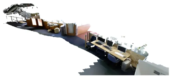
Figure 1.3: Dense mesh-based map representation captured by the SLAM system described in this thesis.
There are a number of map representations producible with visual SLAM systems with the most common being keypoint-based sparse 3D reconstructions. Both mon-ocular SLAM systems (using a single camera, e.g. [17]) and stereo SLAM systems (using a pair of cameras to estimate depth, e.g. [80]) can be used to produce these kinds of maps in real-time, with low cost standard camera technologies. An example of these kinds of maps is shown in Figure 1.2 where the map is only made up of a sparse set of image keypoints used in estimating the camera’s trajectory. Again while useful for localisation and coarse-grained building mapping, this kind of map repres-entation is less useful for general scene understanding and reasoning about free space and other processes that require knowledge of complete surfaces. Other approaches which use standard passive RGB cameras can produce complete surface maps using dense whole image-based techniques (such as that of Newcombeet al. [87]), however these SLAM systems are very much restricted in the area over which they can operate, typically only in desk sized scenes.
The map representation used by the system presented in this thesis is what is typically referred to as dense, where each pixel in the input data is used to
recon-struct the final map. This is partially made possible by the use of a depth sensor as the primary input. Typically referred to as RGB-D sensing (Red, Green, Blue, Depth), every image captured by the camera provides an estimated depth to each pixel as well as color. This can be seen as “shortcutting” the depth estimation prob-lem normally tackled in stereo vision setups, or the structure from motion problem involved in monocular SLAM (later discussed in Chapter 2). Newcombeet al.’s work on KinectFusion exploited this type of data to create dense volumetric surface recon-structions of desk sized scenes [86], similar in appearance to those which could be created with the DTAM monocular SLAM system [87]. The work in this thesis uses the same volumetric representation as KinectFusion in the frontend but converts it to a more scalable dense mesh-based representation in the final backend map represent-ation, allowing massively scalable dense mapping over large scales. This kind of map representation is shown in Figure 1.3. It can be seen that in contrast to other SLAM systems the reconstructions obtained with our approach are useful in many contexts including building layout analysis, 3D scene understanding and motion planning due to their global consistency, high fidelity and full surface reconstruction characteristics.
1.3
Scope
The goal of this thesis is to create a real-time large scale dense visual SLAM system based on RGB-D data that provides high quality surface reconstructions useful for higher level autonomous robotic tasks. Newcombe et al.’s seminal work on real-time dense RGB-D based fused surface reconstruction [86] is a key foundation on which the goals of this thesis are realised. Our work goes beyond previously presented dense RGB-D based visual SLAM systems and is the first of its kind to (i) provide a high quality fused surface reconstruction over extended scales in real-time, (ii) use both dense geometric and photometric information in camera pose estimation, (iii)
1.3. SCOPE
Figure 1.4: System architecture diagram. The major components of the system include; (i) The TSDF Virtual Shift, (ii) ICP+RGB-D Visual Odometry, (iii) Map Space Deformation. Not shown is the planar simplification component, which runs directly off the system output.
provide an up-to-date globally consistent representation of the map in real-time given detected loop closures, and (iv) provide a simplified planar representation of the mapped environment in addition to a dense mesh-based reconstruction.
Our system architecture for accomplishing these goals is shown in Figure 1.4, which follows the approach of a typical SLAM system comprised of a frontend and a backend. The frontend is concerned with camera pose estimation, local fused surface reconstruction and place recognition while the backend performs pose graph optimisa-tion along with dense map optimisaoptimisa-tion to ensure global reconstrucoptimisa-tion consistency. Being highly modular in design the framework is also amenable to the addition of new components and substitution of existing components.
As part of this thesis we introduce efficient GPU-based methods for both extended scale fused surface reconstruction and camera pose estimation inclusive of photometric information. Processing full frame RGB-D data at camera framerate of 30Hz requires computation over 45MB of raw data per second, which necessitates highly parallel GPU-based methods to maintain reliable online operation. The system’s hierarchical multi-threaded architecture facilitates the creation and integration of new modules with minimal impact on the performance of the overall system.
effi-cient manner is a non-trivial task that is necessary when not relying on raw point cloud reprojection for scene reconstruction. In our work we employ a novel para-meterisation of a surface-wide non-rigid space deformation exploiting the information gained through pose graph optimisation. This enables the capture of smooth, locally and globally consistent dense mesh-based maps in real-time over large trajectories.
We provide a comprehensive qualitative and quantitative analysis of many aspects of the system’s performance, demonstrating large scale real-time globally consistent fused surface reconstruction and high quality planar simplification which yields high level information about the area reconstructed. The experimental datasets include both real-world and synthetic data, as well as a standard RGB-D benchmark and numerous other datasets captured in both a handheld fashion and onboard a wheeled robotic platform.
1.4
Publications
The work described in this thesis has appeared in the following publications: Real-time Large Scale Dense RGB-D SLAM with Volumetric Fusion T. Whelan, M. Kaess, H. Johannsson, M.F. Fallon, J. J. Leonard and J.B. McDonald. International Journal of Robotics Research Special Issue on Robot Vision, 2014 [129] Incremental and Batch Planar Simplification of Dense Point Cloud Maps T. Whelan, L. Ma, E. Bondarev, P. H. N. de With, and J.B. McDonald. Robotics and Autonomous Systems ECMR ’13 Special Issue, 2014 [130]
3D Mapping, Localisation and Object Retrieval using Low Cost Robotic Platforms: A Robotic Search Engine for the Real-world
T. Whelan, M. Kaess, R. Finman, M.F. Fallon, H. Johannsson, J.J. Leonard and J.B. McDonald. RSS Workshop on RGB-D: Advanced Reasoning with Depth Cameras, (Berkeley, USA), July 2014 [128]
1.5. STRUCTURE Deformation-based Loop Closure for Large Scale Dense RGB-D SLAM T. Whelan, M. Kaess, J.J. Leonard, and J.B. McDonald. IEEE/RSJ Intl. Conf. on Intelligent Robots and Systems, IROS, (Tokyo, Japan), November 2013 [127]
Planar Simplification and Texturing of Dense Point Cloud Maps
L. Ma, T. Whelan, E. Bondarev, P. H. N. de With, and J.B. McDonald. European Conference on Mobile Robotics, ECMR, (Barcelona, Spain), September 2013 [76] Robust Real-Time Visual Odometry for Dense RGB-D Mapping
T. Whelan, H. Johannsson, M. Kaess, J.J. Leonard, and J.B. McDonald. IEEE Intl. Conf. on Robotics and Automation, ICRA, (Karlsruhe, Germany), May 2013 [126] Kintinuous: Spatially Extended KinectFusion
T. Whelan, M. Kaess, M.F. Fallon, H. Johannsson, J.J. Leonard and J.B. McDon-ald. RSS Workshop on RGB-D: Advanced Reasoning with Depth Cameras, (Sydney, Australia), July 2012 [125]
1.5
Structure
The remainder of this thesis is structured as follows. Chapter 2 provides an overview of the SLAM problem and an introduction to visual SLAM. Following on from this the chapter will provide a discussion on dense methods for 3D reconstruction and mapping. The chapter will end with an in-depth review of the related work relevant to the research presented in this thesis.
Our first contribution, achieving extended scale fused dense real-time RGB-D mapping, is fully described in Chapter 3. An introductory background on volumetric fusion is provided in this chapter, along with our method for extended scale mapping, TSDF parameterisation, surface reconstruction and color estimation.
Chapter 4 describes our second contribution, robust dense visual odometry for volumetric fusion-based mapping. In this chapter we formulate methods for both
geometry-based and photometrics-based camera pose estimation. Following on from this we provide our method for combining geometric and photometric pose estimation into a unified estimate. This chapter also provides a detailed description of how GPU-based parallelisation of the photometric component of the technique was implemented. Chapter 5 describes our approach to combining the techniques outlined in Chapters 3 and 4 with a novel method for performing online dense loop closure to complete our large scale dense visual SLAM system. This is the third contribution of the thesis. In this chapter we provide details of our SLAM framework and each component involved, specifically place recognition, space deformation and map optimisation.
Chapter 6 provides a description of our fourth contribution, a method for per-forming planar simplification and triangulation of dense point cloud maps (such as those produced by our system outlined in Chapter 5). We outline two processing frameworks in this chapter, one for batch processing and one for online incremental processing. The method we use for planar segmentation is provided, as well as de-scriptions of our methods for segment decimation, triangulation and texturing.
In Chapter 7 we provide extensive experimental evaluation of many different as-pects of the presented systems. These include qualitative and quantitative evaluations of camera pose estimation, surface reconstruction quality, segmentation performance, triangulation quality and computational performance.
Chapter 8 describes two case studies where the contributions of this thesis have been applied. The first of these is work on point cloud segmentation carried out by Finman et al. [30, 31]. The second is a fully closed-loop autonomous robotic system which marries techniques presented in this thesis with existing related work to solve a simple robotic task.
Finally, Chapter 9 reviews the contributions of this thesis and discusses future research directions. In particular we focus on real-time robotics applications and the future of dense methods for autonomous platforms.
CHAPTER
2
Visual Simultaneous Localisation and Mapping
The SLAM problem poses the task of estimating a map of an unknown environment whilst simultaneously localising the sensing platform within that map. A wide variety of sensors have been applied to the SLAM problem where visual SLAM refers to the instances where one or more cameras are used as the primary sensor input. In this chapter we will provide an overview of the SLAM problem including its history and the most widely applied solutions to date. We will also specifically review visual SLAM before moving onto a detailed overview of dense mapping and work specifically related to RGB-D based localisation and mapping.
2.1
The SLAM Problem
Although historically embedded in the robotics community, the problem phrased as SLAM is strongly related to earlier research in communities such as photogrammetry where it is referred to asbundle adjustment and the computer vision community where
it is known as structure from motion [120]. Although the same problem in principle, the main differentiator between SLAM and other formulations is the focus on incre-mental solutions and real-time robotics applications. A situation where SLAM would typically be applied involves a mobile robotic platform which requires an estimate of its position within a newly explored environment in real-time in order to make high level decisions for navigation and other purposes. For this reason many of the work on SLAM within the robotics community has focussed on computationally efficient and scalable solutions to the problem.
Smith and Cheeseman are typically credited with carrying out the seminal work on the SLAM problem within the robotics community [106]. Their work set the ini-tial paradigm for approaching the problem by providing a means of estimating the uncertainty and correlations between both the sensor location and the environment structure through use of Approximate Transforms (ATs) estimated with theextended Kalman filter (EKF) [107]. The EKF approach quickly became a key part of sub-sequent real-time SLAM systems [17, 8, 88], but has a number of limitations. The most significant of these is the poor scalability of the filtering-based approach. Al-though the state vector only grows linearly with the size of the map, the covariance grows quadratically (and hence the space and computational complexity as well). This characteristic of the EKF translates into a strict bound on the size of the map which can be computationally feasibly estimated in real-time.
This limitation resulted in a large amount of subsequent research on filter-based SLAM including local submap filtering by Williams [131], sequential map joining by Tardos et al. [118], and the compressed filter algorithm by Guivant and Nebot [40]. However these approaches failed to cancel out the quadratic complexity of the process, only reducing the computation required by a constant factor. One notable exception is the Hierarchical SLAM algorithm of Estrada et al. which managed to achieve linear complexity [28]. Another issue with the EKF approach is the assumed unimodal
2.1. THE SLAM PROBLEM distribution, which meant there was an inherent inability for multiple hypotheses to be naturally represented. This again limits the applicability of the filter in scenarios where perceptual aliasing is encountered or global localisation is required in spite of ambiguity. This manifests itself in the classickidnapped robot problem [119].
The advent of the application of Monte-Carlo methods to robot localisation prob-lems brought with it a much more scalable and computationally favorable means of state representation [20]. Otherwise known as particle filters, these techniques provided a solution to the scalability issues associated with EKF-based SLAM sys-tems. The most notable of these is the FastSLAM system of Montemerloet al. [83]. One of the key intuitions of their system was their Rao-Blackwellization of the problem which represented the posterior distribution as a particle filter over the robot’s path while allocating an independent Kalman filter for each landmark associated with each particle. Central to the computational tractability of this approach is the combina-tion of condicombina-tional independence with Rao-Blackwellizacombina-tion coupled with the use of a tree-based data structure for map management. The FastSLAM approach provides a solution to global localisation and ambiguity problems by naturally supporting the approximation of multimodal distributions.
Although proven to be successful in many applications, Julier and Uhlmann showed that over extended timescales the state estimates provided by filter-based ap-proaches are guaranteed to become inconsistent [54]. This motion against filter-based SLAM was later further argued on a different point by Strasdat et al. concluding that bundle adjustment is more efficient than filtering for visual SLAM [111]. An alternative SLAM paradigm to EKFs and particle filters is sometimes referred to as smoothing or pose graph SLAM. This paradigm has become extremely popular in recent years showing mapping capabilities at scales far beyond what is capable with filter-based approaches. In pose graph SLAM the problem is represented as a set of nodes and edges in a graph, where the nodes represent the latent variables and the
edges represent the measurement constraints between the variables.
Lu and Milios first introduced this representation but chose to only include the sensor poses in the graph and rely on lidar scan projection for map reconstruction [74]. Since then a large amount of research on graph-based solutions to the SLAM problem have been published [91, 71, 69, 41, 19]. One of the most significant qualities of graph-based approaches over filter-graph-based approaches is the fact that the optimisation to solve the SLAM problem maintains all information about all poses that have been recorded so far. This is in contrast to filter-based approaches which marginalise out all previous poses over time. In addition to this the graphical formulation has direct parallels to sparse linear algebra matrix optimisation techniques which have been successfully exploited to achieve highly scalable solutions [56, 57]. In particular in this thesis we make use of the incremental smoothing and mapping (iSAM) approach of Kaess et al. as an efficient means of solving the SLAM problem over the pose graph [56].
iSAM formulates the SLAM problem in the form of a factor graph which consists of variables nodes and factor nodes. Variables nodes are connected to factor nodes by edges in the graph, where a factor node represents a function over all of the variables to which it is connected. As discussed this formulation of the pose graph results in a sparse linear algebra factorisation problem which iSAM exploits to solve the system efficiently. In addition to this, one of the key contributions of iSAM is the efficient and exact method for incrementally updating the factorisation of the system by only recomputing elements of the matrix which actually change [55]. This is of enormous value in real-time settings where new poses are added to the graph incrementally online by the SLAM frontend and there is no longer a need to completely solve the entire system each time this occurs. More recent work on graph-based SLAM looks at robust and efficient means for dealing with outliers in the graph [92, 1, 117, 72]. There has also been focus in recent times on reducing the complexity of the SLAM problem as it scales over time [53] and as graph complexity grows [75].
2.2. VISUAL SLAM
2.2
Visual SLAM
While the majority of early SLAM systems used sensors such as radar, sonar and lidar to perceive the environment, it wasn’t long before systems based on visual information came to the forefront. One of the first was an active stereo vision-based SLAM system that was developed by Davison in his thesis which could capture a consistent map of sparse landmark features [18]. Following on from this was the breakthrough work on visual SLAM using a single monocular camera, also by Davison, in his MonoSLAM system [17]. This approach applied the aforementioned EKF method to SLAM in the domain of monocular vision. MonoSLAM was capable of estimating the pose of the camera in real-time while simultaneously estimating the locations of a sparse set of visual feature points, maintaining full covariance over the entire state vector. One of the key contributions of this work was the introduction of an inverse depth parameterisation for visual landmark features [84].
Many visual SLAM systems have a high degree of focus on real-time operation. The PTAM system of Klein and Murray is one of the key milestones in visual SLAM, where real-time operation was essential to accomplish convincing augmented reality tasks in arbitrary small scale workspaces [65]. Again using only monocular visual information, the PTAM system separated the processes of estimating the camera’s pose and reconstructing the map into two independent parallel threads. This design choice was motivated by the proposition that only tracking needs to be carried out at framerate, while the estimation of the sparse feature map can be carried out in a lower priority intermittent batch thread. Their system avoided the propagation of linearisation errors commonly associated with EKF-based approaches by applying bundle adjustment across a set of wide-baseline keyframes.
Extensions were made to PTAM to extend it to larger scales, such as Castleet al. who adopted a submapping approach [9]. Though successful in mapping building scale environments, the submaps were only topologically connected in the keyframe space
and as a result a global estimate of the environment was unavailable. Other more specifically tailored solutions to large scale visual SLAM include those of Konoligeet al. [67, 68, 70] who presented the FrameSLAM system for large scale mapping, those of Sibley et al. [103, 104] who combined appearance-based place recognition with relative bundle adjustment and that of McDonald et al. [80] which exploits the use of anchor nodes to achieve multi-session visual SLAM over large scales. Up to this point in visual SLAM sparse visual feature maps were the standard. However with an increase in computational power available more recent visual SLAM approaches have looked beyond sparse features towards richer, denser mapping techniques which we discuss in the following sections.
2.3
Dense Mapping
One of the earliest methods for real-time handheld vision-based dense 3D reconstruc-tion was presented by Newcombe and Davison [85]. They leverage the monocular SLAM system of Klein and Murray [65] to bootstrap a dense depth map reconstruc-tion based on view-predictive optical flow and constrained scene flow. Soon after Newcombe et al. published the DTAM system [87], capable of live dense 3D recon-struction of small scale scenes again with only a monocular camera. Their work made use of an inverse depth cost volume with GPU accelerated inverse depth map regu-larisation. Closely related to this system is the work of Stühmer et al. which adopts an arguably simpler method that directly estimates a depth map using a variational approach without a cost volume [114]. A notable recent approach to real-time mon-ocular reconstruction is the semi-dense method of Engel et al. [27], which estimates the inverse depth of all pixels with a non-negligible image gradient with a Gaussian probability distribution.
com-2.4. RELATED WORK munity it was quickly adopted across a number of different fields due to a number of desirable characteristics. It was the first sensor of its kind to provide high resolution (640×480) depth information as well as color information at a 30Hz framerate at such
a low cost. This made it immediately applicable to a number of problems in robotic perception and in particular to visual SLAM. One of the earliest SLAM systems built using the Kinect was that of Henry et al. [43]. Later, KinectFusion brought with it a strong focus on real-time dense 3D volumetric reconstruction at camera frame rate [86]. KinectFusion married the increasing popularity in GPGPU with the high quality real-time full-frame depth maps provided by the Kinect sensor to produce a system capable of camera frame rate dense 3D reconstruction. KinectFusion was the first system able to produce full volumetric 3D reconstructions of desk sized scenes at subcentimetre resolution in real-time, using only a low cost widely available sensor.
Central to the functionality of KinectFusion is the use of a volumetric data struc-ture for representing the reconstruction. The truncated signed distance function (TSDF), first introduced by Curless and Levoy [14], provides a convenient scene rep-resentation which allows computationally efficient means of fusing depth map inform-ation while essentially providing a moving average of the scene being reconstructed, resulting in a much smoother model. The TSDF as a data structure is very amenable to parallel processing and hence perfect for use with GPGPU for enhanced computa-tional performance. This is one of the keys to KinectFusion’s real-time funccomputa-tionality.
2.4
Related Work
In contrast to the previous section, this section will provide a detailed overview of the related work specifically using RGB-D devices over other sensors for visual mapping and localisation. A large number of papers have been published over the last few years specifically using RGB-D data for camera pose estimation, dense mapping and
full SLAM pipelines. While many visual SLAM systems existed prior to the advent of active RGB-D sensors (e.g. Comport et al. [12]), we will focus mainly on the literature which makes specific use of active RGB-D platforms. One of the earliest RGB-D tracking and mapping systems used FAST feature correspondences between frames for visual odometry and offloaded dense point cloud map building to a post-processing step utilising sparse bundle adjustment (SBA) for global consistency by minimising feature reprojection error [50]. One of the first real-time dense RGB-D tracking and mapping systems estimates an image warping function with both geometric and photometric information to compute a camera pose estimate, however only relied on rigid reprojection for point cloud map reconstruction without using a method for global consistency [3]. Similar work on dense RGB-D camera tracking was done by Steinbrückeret al., also estimating an image warping function based on geometric and photometric information [108]. Recent work by Kerl et al. presents a more robust dense photometrics-based RGB-D visual odometry system that proposes a t-distribution-based error model which more accurately matches the residual error between RGB-D frames in scenes that are not entirely static [62].
Henry et al. presented one of the first full SLAM systems based entirely upon RGB-D data, using visual feature matching with Generalised Iterative Closest Point (GICP) to build up a pose graph and following that an optimised surfel map of the area explored [43]. The use of pose graph optimisation versus SBA is evaluated, min-imising feature reprojection error in an offline rigid transformation framework. Visual feature correspondences are used in conjunction with pose graph optimisation in the RGB-D SLAM system of Endres et al. [26]. An octree-based volumetric represent-ation is used to store the map, created by reprojecting all point measurements into the global frame. This map representation is provided by the OctoMap framework of Hornunget al., which includes the ability to take measurement uncertainties into ac-count and implicitly represent free and occupied space while being space efficient [47].
2.4. RELATED WORK An explicit voxel volumetric occupancy representation is used by Pirkeret al. in their GPSlam system which uses sparse visual feature correspondences for camera pose es-timation [95]. They make use of visual place recognition and sliding window bundle adjustment in a pose graph optimisation framework. To achieve global consistency the occupancy grid is “morphed” by a weighted average of the log-odds perceptions of each camera for each voxel. Stückler et al. register surfel maps together for camera pose estimation and store a multi-resolution surfel map in an octree, using pose graph optimisation for global consistency [113]. After pose graph optimisation is complete a globally consistent map is created by fusing key views together. In recent work Hu et al. proposed a system that uses bundle adjustment in order to make use of pixels for which no valid depth exists [49], and Leeet al. presented a system which exploits GPU processing power for real-time camera tracking [73]. Both systems produce an optimised map as a final step in the process. Kerlet al. use their previously discussed dense keybased visual odometry system in a pose graph optimisation frame-work to build a dense visual SLAM system that produces keyframe-based globally consistent maps after a final post-processing optimisation step [63].
A substantial number of derived works have been published recently after the advent of the KinectFusion system of Newcombe et al. [86], mostly focused on ex-tending the range of operation, with other related work on object recognition and motion planning [59, 124]. Recent work by Bylow et al. and Canelhas et al. directly tracks the camera pose against the accumulated volumetric model by exploiting the fact that the TSDF representation used by KinectFusion stores the signed distance to the closest surface at voxels near the surface [6, 7]. This avoids the need to raycast a vertex map for each frame to perform camera pose estimation, which potentially discards information about the surface reconstruction.
Roth and Vona extend the operational range of KinectFusion by using a double buffering mechanism to map between volumetric models upon camera translation
and rotation, using a voxel interpolation for the latter [97]. However no method for recovering the map is provided. Zeng et al. replace the explicit voxel representation used by KinectFusion with an octree representation which allows mapping of areas up to 8m×8m×8m in size [132]. However this method does increase the chance
for drift within the map and provides no means of loop closure or map correction. Steinbrückeret al. make use of a multi-scale octree to represent the signed distance function, allowing full color reconstructions of scenes as large as an entire corridor including nine rooms spanning a total area of 45m×12m×3.4m [109]. After an
RGB-D sequence has been processed, a globally consistent camera trajectory is resolved and the model is reconstructed. Keller et al. present an extended fusion system made space efficient by using a point-based surfel representation, although with no method for drift correction or loop closure detection [61]. Chenet al. present a novel hierarchical data structure that enables extremely space efficient volumetric fusion, using a streaming framework allowing effectively unbounded mapping range, limited only by available memory [10]. However the system lacks any method for mitigating drift or enforcing global consistency. Nießner et al. present an alternative space efficient method for large scale dense fusion that uses an intelligent voxel hashing function to minimise the amount of memory required for reconstruction, but again without a means of correcting for drift [89].
An alternative approach to the modern SLAM problem (making use of higher level semantic information) is introduced by Salas-Moreno et al., whereby known objects are detected, tracked and mapped in real-time in a dense RGB-D framework known as SLAM++ [99]. Pose graph optimisation is used to ensure global consistency on the level of camera poses and detected object positions. This does allow loop closure, however less influence is placed on a full scene reconstruction with only point cloud reprojections being used for mapped loop closure. Recent work by Henry et al. uses multiple smaller “patch volumes” to segment the mapped space into a set
2.4. RELATED WORK of discrete TSDFs, each with a 6-degrees-of-freedom (6-DOF) pose which is rigidly optimised upon loop closure detection [45]. This approach can be seen as similar to the SLAM++ approach of Salas-Morenoet al. whereby the patch volumes are analogous to objects. While achieving global consistency between each volume, there is no clear solution presented for correcting the surface within any one given volume or stitching surfaces which are split between volumes, leaving local surfaces disconnected.
Zhou et al. present an impressive method for reconstructing 3D scenes that spe-cifically targets the high-frequency noise and low-frequency distortion effects often encountered with RGB-D data [134]. By reconstructing fragments of the scene which are then aligned and deformed very high quality reconstructions can be obtained, how-ever in what is a strictly offline framework. Similar work also by Zhou and Koltun presents a method which detects points of interest in a scene and specifically optim-ises the camera trajectory to preserve detailed geometry around these points, within an offline framework [133].
An number of approaches that rely on keyframes have been developed to tackle the problem of RGB-D mapping and SLAM. Tykkäläet al. present a system which uses real-time dense photometric keyframe-based camera tracking to determine a camera trajectory around an indoor environment [121]. Individual RGB-D frames are also fused into existing keyframes to improve reconstruction quality. An optional bundle adjustment step can then be taken to optimise the camera poses before a water-tight Poisson mesh reconstruction is computed as a post-processing step. Meilland and Comport propose a model that unifies the benefits of a dense voxel-based rep-resentation with a keyframe reprep-resentation allowing high quality dense mapping over large-scales, although without detecting large loop closures or correcting for drift [81]. An intelligent forward composition approach is proposed which enables efficient com-bination of reference images to create a single predicted frame without repeated re-dundant image warps. In our work we chose to avoid a keyframe approach in spite
of the resulting higher memory requirement. A fully 3D voxel-based method, such as the one presented in this thesis, removes the need to implement specific schemes to overcome the problems associated with reconstructing complex non-concave objects and non-convex scenes.
On the topic of map representation and planar simplification, triangular meshing of 3D point clouds is a well-studied problem with many existing solutions. One class of triangulation algorithms computes a mathematical model prior to triangulation to ensure a smooth mesh while being robust to noise [60, 52]. This type of algorithm assumes surfaces are continuous without holes, which is usually not the case in open scene scans or maps acquired with typical robotic sensors. Another class of algorithms connects points directly, mostly being optimised for high-quality point clouds with low noise and uniform density. While these algorithms retain fine details in objects [5, 101], they are again less applicable to noisy datasets captured with an RGB-D or lidar sensor, where occlusions create large discontinuities.
With real-world environment triangulation in mind, the Greedy Projection Tri-angulation (GPT) algorithm has been developed [39, 79]. The algorithm creates triangles in an incremental mesh-growing approach, yielding fast and accurate trian-gulations. However, the GPT algorithm keeps all available points to preserve geo-metry, which is not always necessary for point clouds containing surfaces that are easily characterised by geometric primitives. To solve this problem a hybrid trian-gulation method was developed by Ma et al., where point clouds are segmented into planar and non-planar regions for separate triangulation [77]. The QuadTree-Based (QTB) algorithm was developed to decimate planar segments prior to triangulation. The QTB algorithm significantly reduces the amount of redundant points, although a number of limitations degrade its performance. For example, the algorithm does not guarantee that final planar points will lie inside the original planar region, which can lead to noticeable shape distortion. The algorithm also produces duplicate vertices,
2.4. RELATED WORK overlapping triangles and artificial holes along the boundary.
There is a vast amount of literature on planar segmentation available. Oehler et al. adopt a multi-resolution approach that relies on using a Hough transform over co-planar clusters of surfels, ultimately relying on RANSAC for the plane fitting component [90]. Deschaud and Goulette use a region growing approach made robust to noise by growing in a voxel space over the input data rather than the raw points themselves [21]. Some algorithms extend 2D graph cut theory towards 3D point cloud data [38, 37, 112]. These algorithms are designed for general object segmentation and their complexity is in general too high for plane detection, unlike the low-complexity algorithm proposed by Rabbani et al. [96], which imposes a smoothness constraint on segmentation. However, like in previous work these methods are all concerned with batch processing scenarios rather than the incremental segmentation growing scenario [77]. Related also is the work of Ruhnke et al. which looks at simplifying dense point cloud maps by learning local surface attributes via sparse coding, rather than explicitly extracting geometric primitives [98].
As discussed there exists a large number of systems utilising RGB-D data for SLAM and related problems. However, most are either unable to (i) operate in real-time, (ii) provide an up-to-date optimised representation of the map at runtime or any time it is requested or (iii) efficiently incorporate large non-rigid updates to the map. Non-rigid surface correction is of great interest specifically in the realm of volumetric fusion as typically reconstructions are locally highly accurate but drift slowly over large scales over time, where a smooth continuous deformation of the surface is most suitable for correction. Additionally, while there is a significant amount of existing work on planar simplification and triangulation, none of the methods discussed above are optimal for the type of data we wish to process in a potentially real-time framework. In the following chapters we will fully describe our approach to RGB-D SLAM with volumetric fusion which is capable of functioning in real-time
over large scale trajectories, while efficiently applying non-rigid updates to the dense map upon loop closure to ensure global consistency. We will also describe our method for efficient planar simplification and triangulation of dense point cloud maps, in both batch and incremental online settings.
CHAPTER
3
Extended Scale Dense Mapping
In this chapter we will provide some background on the usage of volumetric fusion for dense RGB-D based tracking and mapping and describe our extension to Kinect-Fusion, the most widely cited system that employs this approach, to allow spatially extended mapping.
3.1
Background
Real-time volumetric fusion with RGB-D cameras was brought to the forefront by Newcombe et al. with the KinectFusion system [86]. A significant component of the system is the cyclical pipeline used for camera tracking and scene mapping, whereby full depth maps are fused into a volumetric data structure, which is then raycast to produce a predicted surface that the subsequently captured depth map is matched against using ICP. We review the method for integrating new depth maps into the volumetric data structure in Section 3.2, while our method for tracking the camera
Figure 3.1: Two dimensional example of the structure of the truncated signed distance function representation of an implicit surface. Shown are example signed distance values stored at voxels within the truncation distance of the observed surface, with rays cast from the observing sensor.
motion against the predicted surface model is described in Chapter 4. The truncated signed distance function (TSDF) is the volumetric data structure used that encodes implicit surfaces by storing the signed distance to the closest surface at each voxel up to a given truncation distance from the actual surface position. Points at which the sign of the distance value changes are known as zero crossings, which represent the actual position of the surface, shown in Figure 3.1. Each voxel also stores a weight for the distance measurement at that point, effectively providing a moving average of the surface position. In the case of KinectFusion, the TSDF is stored as a three dimensional voxel grid in GPU memory where dense depth map integration is accomplished by sweeping through the volume and updating distance measurements accordingly, while surface raycasting is carried out by simply projecting rays from the current camera pose and returning the depth and surface normals at the first zero crossings encountered. Surface normals are easily computed by taking the finite difference around a given position within the TSDF, as exploited by Bylow et al. [6]
3.2. VOLUME REPRESENTATION and Canelhas et al. [7]. The entire process is very amenable to parallelisation and greatly benefits in execution time from being implemented on a GPU. A point to note is that the TSDF representation has a minimal surface thickness limitation imposed by the selected truncation distance. This manifests itself in the fact that two surfaces closer than the selected truncation distance will effectively “overwrite” each other when observed. This problem was highlighted and explored by Henry et al. in their work on multiple fusion volumes [44].
3.2
Volume Representation
Defining the voxel space domain as Ψ ⊂ N3 the TSDF volume S at some location
s ∈ Ψ has the mapping S(s) : Ψ → R×N×N3. Within GPU memory the TSDF
is represented as a 3D array of voxels. Each voxel contains a signed distance value
S(s)D, a weight value S(s)W and a value for each color component R, G and B
(S(s)R, S(s)G, S(s)B). The integration of new surface measurements (i.e. depth map
values projected into the TSDF from the current camera pose) is carried out in the same fashion as Newcombe et al., when integrating a new signed distance function measurementS(s)Di during the fusion of a new depth map, each voxel s∈Ψat time iis updated with: S(s)Di 0 = S(s) W i−1S(s)Di−1+S(s)Wi S(s)Di S(s)W i−1+S(s)Wi (3.1)
S(s)Wi 0 =min(S(s)iW−1+S(s)Wi , max_weight) (3.2)
As is the case with previous approaches, we take S(s)W
i = 1 to provide a simple
moving average. Bylowet al. have experimented with different weighting schemes [6], however we have found the original value of 1 used by Newcombe et al. to provide good performance [86]. Using only a cubic volume, we parameterise the TSDF by the
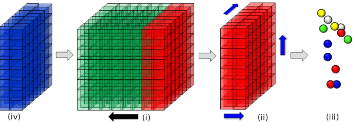
Figure 3.2: Visualisation of the volume shifting process for spatially extended map-ping; (i) The camera motion exceeds the movement thresholdms(direction of camera
motion shown by the black arrow); (ii) Volume slice leaving the volume (red) is raycast along all three axes to extract surface points and reset to free space; (iii) The raycast surface is extracted as a point cloud and fed into the Greedy Projection Triangulation (GPT) algorithm of Marton et al. [79]; (iv) New region of space (blue) enters the volume and is integrated using new modulo addressing of the volume.
side length in voxels, vs, and the dimension in metres, vd. Both of these parameters
control the resolution of the reconstruction along with the size of the immediate “active area” of reconstruction. In all experiments we set vs = 512 for total GPU
memory usage of 768MB, where each signed distance value is a truncated float16 and each weight and color component value is an unsigned int8. The 6-DOF camera pose within the TSDF at timei is denoted as PT
i , composed of a rotationRTi ∈SO3
and a translation tTi ∈ R3. The origin of the TSDF coordinate system is positioned
at the center of the volume with basis vectors aligned with the axes of the TSDF. Initially RT0 =Iand tT0 = (0,0,0)>. The position of the TSDF volume in voxel units
in the global frame is defined by gi and initialised to be g0 = (0,0,0)>. Note that
the superscript T refers to a pose within the TSDF coordinate frame and not the
3.3. VOLUME SHIFTING
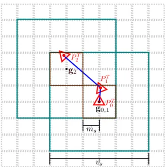
Figure 3.3: Visualisation of the interaction between the movement threshold ms and
the shifting process. Between frames 0 and 1 the camera does not cross the movement boundary (dark brown) and no shift occurs. At frame 2, the pose crosses the boundary and causes a volume shift, recentering the volume (teal) aroundP2T and updating g2.
The underlying voxel grid quantisation is shown in light dashed lines.
3.3
Volume Shifting
Unlike the original work of Newcombe et al., camera pose estimation and surface reconstruction is not restricted to only the region around which the TSDF was ini-tialised. By employing modulo arithmetic in how the TSDF volume is addressed in GPU memory we can treat the structure like a cyclical buffer which virtually trans-lates as the camera moves through an environment. Figure 3.2 provides a visual example and description of the shifting process. It is parameterised by an integer movement threshold ms, defining the cubic movement boundary (in voxels) around gi which upon crossing, causes a volume shift, shown in Figure 3.3. Discussion on
the choice of value for ms is provided in Chapter 7. Each dimension is treated
inde-pendently during a shift. When a shift is triggered, the TSDF is virtually translated about the camera pose (in voxel units) to bring the camera’s position to within one voxel of gi+1. The new pose of the camera PiT+1 has no change in rotation, while the
shift corrected camera translationtTi+10 is calculated from tTi+1 by first computing the
number of voxel units crossed;
u= vstTi+1 vd (3.3) and then shifting the pose while updating the global position of the TSDF;
tTi+10 =tTi+1− vdu
vs
(3.4)
gi+1 =gi+u (3.5)
3.3.1
Implementation
There are two parts of volumetric fusion that require indexed access to the TSDF volume; 1) Volume Integration and 2) Volume Raycasting. Referring again to Figure 3.2, the new surface measurements shown in blue can be integrated into the memory previously used for the old surface contained within the red region of the TSDF by ensuring all element look ups in the 3D block of GPU memory reflect the virtual voxel translation computed in Equation 3.5. Assuming row major memory ordering, an element in the unshifted cubic 3D voxel grid can be found at the 1D memory locationa given by:
a= (x+yvs+zv2s) (3.6)
The volume’s translation can be reflected in how the TSDF is addressed for integration and raycasting by substituting the indices in Equation 3.6 with values that are offset by the current global position of the TSDF and bound within the dimensions of the
3.3. VOLUME SHIFTING voxel grid using the modulus operator:
x0 = (x+gix) mod vs (3.7) y0 = (y+giy) mod vs (3.8) z0 = (z+giz) modvs (3.9) a= (x0+y0vs+z0vs2) (3.10)
The original KinectFusion work benefits greatly from memory caching and pipelining functionality within GPU memory to achieve high computational performance within the integration step [86]. In our implementation we have found that use of a cyclical addressing method has no significant effect on real-time performance. An explanation for the lack of a drastic performance decrease is that even after buffer cycling there still exists continuous blocks of memory which at least partially maintain pipelining.
3.3.2
Surface Extraction
In order to recover the surface from the TSDF that moves out of the region of space encompassed by the volume, the u value computed in Equation 3.3 is used with gi to index a three dimensional slice of the volume to extract surface points from.
These points are extracted by three orthogonal raycasts aligned with the axes of the TSDF through the slice, extracting zero crossings as individual surface vertices. We filter out noisy measurements at this point by only extracting points that are above a minimum voxel weight. The same 3D slice of the volume is then reset to free space to allow integration of new surface measurements. The extracted vertices are transferred to main system memory where further processing takes place. The orthogonal raycast can result in duplicate vertices if the TSDF is obliquely aligned to the surface being reconstructed. A voxel grid filter is used to remove these points by overlaying a voxel grid (with the same voxel size as the TSDF) on the extracted point
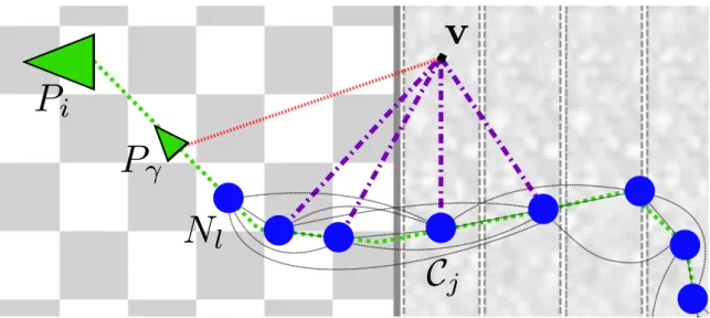
Figure 3.4: Two dimensional visualisation of the association between extracted cloud slices, the camera poses and the TSDF volume. Note that the camera poses here are in global coordinates rather than internal TSDF coordinates. A red dashed line links camera poses with extracted slices of the TSDF volume (Pγ, Pβ and Pα with C2,C1
and C0 respectively). The large triangles represent camera poses that caused volume
shifts while the small black squares represent those that didn’t.
cloud and returning a new point cloud with a point for each voxel that represents the centroid of all points that fell inside that voxel. Each set of vertices extracted from the TSDF in this fashion is known as a “cloud slice”. From here, we rebuild the surface by incrementally triangulating successive cloud slices using an incremental mesh growing variant of the GPT algorithm to ensure surface connectivity between slices [79].
We choose not to perform marching cubes because this would lock the TSDF data structure in GPU memory and delay the reset of the extracted volume slice, impacting volume shifting performance overall. Axis-aligned orthgonal raycasting is extremely fast and allows us to offload the data from the GPU and unlock the TSDF volume as quickly as possible. This way the GPU-based tracking and integration components of the system can continue with minimal interruption while the extracted cloud slice is triangulated on the CPU asynchronously.
3.3. VOLUME SHIFTING
Figure 3.5: Visualisation of a shifted TSDF volume with extracted cloud slices and pose graph highlighted, using dynamic cube positioning discussed in Section 3.4. The pose graph is drawn in pink, while small cuboids are drawn for camera poses that have cloud slices associated with them. Note that the apparent striping of the boundaries between slices has been added for visualisation purposes only.
![Figure 1.1: The Intel Research Lab dataset, one of the most well known 2D laser scan SLAM sequences in the community [48].](https://thumb-us.123doks.com/thumbv2/123dok_us/11060967.2992810/20.892.287.648.204.568/figure-intel-research-dataset-known-laser-sequences-community.webp)