optical and radar satellite data Author(s) Ali, Iftikhar
Publication date 2016
Original citation Ali, I. 2016. Retrieval of grassland biophysical parameters using multitemporal optical and radar satellite data. PhD Thesis, University College Cork.
Type of publication Doctoral thesis Rights © 2016, Iftikhar Ali.
http://creativecommons.org/licenses/by-nc-nd/3.0/
Embargo information Restricted to everyone for one year Embargo lift date 2017-05-16T15:46:30Z
Item downloaded
from http://hdl.handle.net/10468/2582
R E T R I E VA L O F G R A S S L A N D B I O P H Y S I C A L
PA R A M E T E R S U S I N G M U LT I T E M P O R A L O P T I C A L A N D
R A D A R S AT E L L I T E D ATA
i f t i k h a r a l i
,
m s c
Dissertation submitted to the
University College Cork for the degree of
Doctor of Philosophy
NATIONAL UNIVERSITY OF IRELAND, CORK
DEPARTMENT OF GEOGRAPHY
February,
2016
Supervisor: Dr. Fiona Cawkwell
Advisors: Mr. Stuart Green
Dr. Edward Dwyer
Head of Department: Prof. Dr. Donald I. Lyons
Copyright c2016by I. Ali
{iffi.math@gmail.com}
All rights reserved. No part of the material protected by this copyright notice may be reproduced or utilized in any form without the prior per-mission of the author.
Cite this thesis as follow:
Ali, I. 2016. Retrieval of grassland biophysical parameters using multitemporal
optical and radar satellite data. Ph.D thesis, University College Cork, Cork,
Seek knowledge from the cradle to the grave.
— Prophet Muhammad (PBUH)
I
–IftikharAli–dedicate my PhD thesis to all the victims of terrorismand specially to the martyred1
and injured school childern of
Army Public School in Peshawar (KPK, Pakistan) on16th Dec.2014.
A B S T R A C T
The amount and quality of available biomass is a key factor for the sus-tainable livestock industry and agricultural management related decision
making. Globally 31.5% of land cover is grassland while 80% of Ireland’s
agricultural land is grassland. In Ireland, grasslands are intensively man-aged and provide the cheapest feed source for animals. This dissertation presents a detailed state of the art review of satellite remote sensing of grasslands, and the potential application of optical (Moderate–resolution
Imaging Spectroradiometer (MODIS)) and radar (TerraSAR-X) time series
imagery to estimate the grassland biomass at two study sites (Moorepark and Grange) in the Republic of Ireland using both statistical and state of the art machine learning algorithms. High quality weather data available from the on-site weather station was also used to calculate the Growing
Degree Days (GDD) for Grange to determine the impact of ancillary data
on biomass estimation.
In situ and satellite data covering12years for the Moorepark and6years
for the Grange study sites were used to predict grassland biomass using
multiple linear regression, Artificial Neural Networks (ANN) and Adaptive
Neuro Fuzzy Inference Systems (ANFIS) models. The results demonstrate
that a dense (8-day composite) MODIS image time series, along with high
quality in situ data, can be used to retrieve grassland biomass with high
performance (R2
= 0.86, p < 0.05, RMSE = 11.07 for Moorepark). The
model for Grange was modified to evaluate the synergistic use of
information. AsGDDis strongly linked to the plant development, or pheno-logical stage, an improvement in biomass estimation would be expected. It was observed that using the ANFIS model the biomass estimation accuracy
increased from R2
= 0.76 (p < 0.05) to R2 = 0.81 (p < 0.05) and the root
mean square error was reduced by2.72%.
The work on the application of optical remote sensing was further de-veloped using a TerraSAR-X Staring Spotlight mode time series over the Moorepark study site to explore the extent to which very high resolution
Synthetic Aperture Radar (SAR) data of interferometrically coherent
pad-docks can be exploited to retrieve grassland biophysical parameters. After filtering out the non-coherent plots it is demonstrated that interferometric coherence can be used to retrieve grassland biophysical parameters (i. e., height, biomass), and that it is possible to detect changes due to the grass growth, and grazing and mowing events, when the temporal baseline is
short (11days). However, it not possible to automatically uniquely identify
the cause of these changes based only on theSARbackscatter and coherence,
due to the ambiguity caused by tall grass laid down due to the wind. Overall, the work presented in this dissertation has demonstrated the potential of dense remote sensing and weather data time series to predict grassland biomass using machine-learning algorithms, where high quality ground data were used for training. At present a major limitation for na-tional scale biomass retrieval is the lack of spatial and temporal ground samples, which can be partially resolved by minor modifications in the ex-isting PastureBaseIreland database by adding the location and extent of
each grassland paddock in the database. As far as remote sensing data
re-quirements are concerned, MODIS is useful for large scale evaluation but
due to its coarse resolution it is not possible to detect the variations within the fields and between the fields at the farm scale. However, this issue will
be resolved in terms of spatial resolution by the Sentinel-2 mission, and
when both satellites (Sentinel-2A and Sentinel-2B) are operational the
re-visit time will reduce to 5 days, which together with Landsat-8, should
enable sufficient cloud-free data for operational biomass estimation at a national scale.
The Synthetic Aperture Radar Interferometry (InSAR) approach is feasible
if there are enough coherent interferometric pairs available, however this is difficult to achieve due to the temporal decorrelation of the signal. For
repeat-passInSARover a vegetated area even an 11days temporal baseline
is too large. In order to achieve better coherence a very high resolution is required at the cost of spatial coverage, which limits its scope for use in
an operational context at a national scale. FutureInSAR missions with pair
acquisition in Tandem mode will minimize the temporal decorrelation over vegetation areas for more focused studies.
The proposed approach complements the current paradigm of Big Data in Earth Observation, and illustrates the feasibility of integrating data from multiple sources. In future, this framework can be used to build an opera-tional decision support system for retrieval of grassland biophysical param-eters based on data from long term planned optical missions (e. g., Land-sat, Sentinel) that will ensure the continuity of data acquisition. Similarly,
of TerraSAR-X and COSMO-SkyMed.
P U B L I C AT I O N S
Peer Reviewed Journal Articles:
[1] Ali, I.; Cawkwell, F.; Dwyer, E.; Barrett, B.;
and Green, S.; 2016, "Satellite remote sensing of grasslands: from observation to management— a review", Journal of Plant Ecology, doi:
10.1093/jpe/rtw0052
. [IF:2.646]
[2] Ali, I.; Cawkwell, F.; Dwyer, E.; and Green,
S.;2016,"Modelling managed grassland biomass estimation by using multitemporal remote sens-ing data—a machine learnsens-ing approach", Journal of Selected Topics in Applied Earth Observa-tions and Remote Sensing, IEEE. [Accepted, (IF:3.026)]
[3] Ali, I.; Cawkwell, F.; Dwyer, E.; and Green,
S.; 2016, "Synergetic use of remote sensing and weather data to retrieve grassland biomass and growth rate", International Journal of Applied Earth Observation and Geoinformation. [Sub-mitted, (IF:3.470)]
[4] 3 Ali, I.; Barrett, B.; Cawkwell, F.; Green, S.;
Dwyer, E.; Neumann, M.:2016,"Limitations Of Repeat-Pass TerraSAR-X (Staring Spotlight Mode) InSAR Coherence To Monitor Pasture Biophysical Parameters", Journal of Selected Topics in Ap-plied Earth Observations and Remote Sensing, IEEE. [Accepted (IF:3.026)]
[5] Ali, I.; Greifeneder, F.; Stamenkovic, J.;
Neu-mann, N.; Notarnicola, C.: 2015, "Review of biomass and soil moisture retrievals by using ma-chine learning methods and remote sensing data", Remote Sens.2015,7,16398-16421. [F:3.180] Non–Peer Reviewed Articles:
[1] Green, S.; Ali, I.; Cawkwell, F.;2013,
"Moni-toring grass from space, using satellite imaging to observe and predict grass growth rates". Teagasc Research, volume8number4, ISSN1649-8917:
pp.34-35,2013.
Conference Poster/Proceedings:
[1] Ali, I.;Cawkwell, F.; Green, S.; and Dwyer, E.;
2016, "Grassland biomass retrieval using multi-temporal optical satellite remote sensing time se-ries", Living Planet Symposium, 09–13 May, 2016in Prague, Czech Republic. [Submitted]
[2] Barrett, B.; Raab, C.; Ali, I.; Green, S.; and
Cawkwell, F.;2016,"Grassland management and biomass retrieval in an intensive dairy farm in Ire-land using a combination of RADARSAT-2and TerraSAR-X data", Living Planet Symposium,
09–13 May, 2016 in Prague, Czech Republic.
[Submitted]
[3] Ali, I.;Cawkwell, F.; Green, S.; and Dwyer, E.;
2014,"Application of statistical and machine learn-ing modelds for grassland yield estimation based on a hypertemporal satellite remote sensing time se-ries”, IEEE IGARSS,13–18July,2014in Quebec,
Canada.
[4] Ali, I.;Cawkwell, F.; Green, S.; and Dwyer, E.;
2014,"Grassland biomass estimation using satel-lite data". Agricultural Research Forum 2014, 10th&11thMarch, Tullamore, Co. Offaly,
Ire-land.
[5] Ali, I.;Cawkwell, F.; Green, S.; and Dwyer, E.;
2013,"Grassland yield estimation based on satel-lite data: A machine Learning Approach".7thIrish
Earth Observation Symposium24−25thOctober
2013Teagasc Ashtown Research Centre, Dublin. [Best presentation award]
[6] Green, S.; Cawkwell, F.; Ali, I.; 2013, "New
remote sensing tools to monitor grass growth”, A Conference on Agriculture and Future Weather Patterns.5thDecember2013, Teagasc
Ashtown Research Centre, Dublin.
2 Online available at: http://jpe.oxfordjournals.org/content/early/2016/02/02/jpe.
rtw005.abstract?sid=37fbd6ed-e24a-4ce7-9992-8c7457cbced6
3 This research was conducted during my stay at JPL/NASA.
A C K N O W L E D G E M E N T S
There are no limitations to the mind except those we acknowledge. —Napoleon Hill[1883—1970]
I
would like to express my special appreciation and thanks to my supervisorsDr. Fiona Cawkwell, Mr. Stuart Green and Dr. Edward Dwyer, you have been a tremendous mentor for me. I would like to thank you for encouraging my research and for allowing me to grow as a research scientist. Your advice on both research as well as on my career have been priceless. I am also deeply grateful to Teagasc for funding this research.A special thanks to my family. Words cannot express how grateful I am to my uncle, aunt, father, and my mother for all of the sacrifices that you have made on my behalf. Your prayer for me was what sustained me thus far. I would also like to thank all of my friends who supported me in writing, and incented me to strive towards my goal.
I cannot imagine the happiness of my parents upon my graduation, I wish they were present at my graduation ceremony. I would like to thanks my aunt Razia Bibi and uncle Haji Abdur Rashid Maan, parents (Mother: Saleema Bibi, Father: Muhammad Khan Maan), brother Dr. Nasir Mahmood and sisters Nasira Perveen and Sajida Perveen for their prayers, support and unconditional love.
At the end I would like express appreciation to my beloved wife Tayyaba Iram and son Issa Ali who spent sleepless nights with and was always my support in the moments when there was no one to answer my queries.
C O N T E N T S
i p r o j e c t b a c k g r o u n d a n d l i t e r at u r e r e v i e w 1 1 i n t r o d u c t i o n 3
1.1 Importance of grasslands 5
1.2 Agriculture and climate change 7
1.2.1 Global context 7
1.2.2 Irish context 13
1.2.2.1 GHG emissions from the agriculture sector 14
1.2.2.2 Trends in GHG emissions from agriculture
sector 15
1.2.2.3 Mitigating GHG emissions from the
agricul-ture sector 16
1.3 Irish agricultural trends 16
1.4 Milk quota – economic value 18
1.5 Current situation 19
1.6 Motivation for this work 20
1.7 Remote sensing technology – scope and potential 22
1.8 Objectives 26
1.9 Chapter overview 27
2 s at e l l i t e r e m o t e s e n s i n g o f g r a s s l a n d s 31
2.1 Paper—1 32
2.1.1 Ali, I.;Cawkwell, F.; Dwyer, E.; Barrett, B.; and Green,
S.; 2016, "Satellite remote sensing of grasslands: from ob-servation to management—a review",Journal of Plant
Ecol-ogy, doi: 10.1093/jpe/rtw005. [IF:2.646] 32
ii r e m o t e s e n s i n g a n d m a c h i n e l e a r n i n g b a s e d g r a s s -l a n d b i o m a s s e s t i m at i o n 115
3 m o d e l l i n g b i o m a s s e s t i m at i o n o f m a na g e d g r a s s l a n d s 117
3.1 Paper—2 118
3.1.1 Ali, I.; Cawkwell, F.; Dwyer, E.; and Green, S.; 2016, "Modelling managed grassland biomass estimation by us-ing multitemporal remote sensus-ing data—a machine learn-ing approach", IEEE Journal of Selected Topics in Ap-plied Earth Observations and Remote Sensing.
[Ac-cepted, (IF: 3.026)] 118
3.2 Additional Commentary 157
3.2.1 Total annual yield 157
4 f u s i o n o f r e m o t e s e n s i n g a n d w e at h e r d ata 161
4.1 Paper—3 162
4.1.1 Ali, I.; Cawkwell, F.; Dwyer, E.; and Green, S.; 2016, "Synergetic use of remote sensing and weather data to re-trieve grassland biomass and growth rate", International Journal of Applied Earth Observation and
Geoinfor-mation. [Submitted, (IF: 3.470)] 162
c o n t e n t s xiii iii s y n t h e t i c a p e r t u r e r a d a r i n t e r f e r o m e t r y o n g r a s s -l a n d s 191 5 r e t r i e va l o f g r a s s l a n d b i o p h y s i c a l pa r a m e t e r s u s i n g s a r i n t e r f e r o m e t r y 193 5.1 Paper—4 194
5.1.1 Ali, I.; Barrett, B.; Cawkwell, F.; Green, S.; Dwyer, E.;
Neumann, M.:2016,"Limitations Of Repeat-Pass
TerraSAR-X (Staring Spotlight Mode) InSAR Coherence To Moni-tor Pasture Biophysical Parameters", Journal of Selected Topics in Applied Earth Observations and Remote
Sens-ing, IEEE. [Accepted (IF:3.026)] 194
iv c o n c l u s i o n a n d b i b l i o g r a p h y 223
6 s u m m a r y, c o n c l u s i o n a n d f u t u r e r e s e a r c h 225
6.1 Future research 232
Figure1 Total annual anthropogenic GHG emissions by gases 1970–2010(IPCC, 2014). 8
Figure2 Relative contribution of world regions to milk
pro-duction and GHG emissions associated with milk production, processing and transportation (source:
http://www.fao.org/docrep/012/k7930e/k7930e00.
pdf). 13
Figure3 Ireland: greenhouse gas emissions in 1990 and 2014
by sector (EPA,2014). 15
Figure4 Teagasc grassland biomass estimation method
(Pho-tographs were taken during the Curtins (Teagasc farm)
field campaign). 22
Figure5 Graphical abstract of this review: Ali, I.; Cawkwell,
F.; Dwyer, E.; Barrett, B.; and Green, S.; 2016,
"Satel-lite remote sensing of grasslands: from observation to management— a review",Journal of Plant Ecology, doi:10.1093/jpe/rtw005.
[IF: 2.646] 33
List of Figures xv
Figure6 Graphical abstract of this paper: Ali, I.; Cawkwell,
F.; Dwyer, E.; and Green, S.; 2016, "Modelling
man-aged grassland biomass estimation by using multitempo-ral remote sensing data—a machine learning approach", IEEE Journal of Selected Topics in Applied Earth Observations and Remote Sensing. [Accepted, (IF:
3.026)] 120
Figure7 Moorepark total annual yield (t/ha). 158
Figure8 Grange total annual yield (t/ha). 158
Figure9 Graphical abstract of this paper: Ali, I.; Cawkwell,
F.; Dwyer, E.; and Green, S.; 2016, "Synergetic use
of remote sensing and weather data to retrieve grassland biomass and growth rate", International Journal of Ap-plied Earth Observation and Geoinformation.
[Sub-mitted, (IF: 3.470)] 164
Figure10 Large scale model evaluation to retrieve grassland
biomass using IBM weather forecast data and
re-mote sensing Vegetation Indices (VI). A: Normalized
Difference Vegetation Index (NDVI), B: accumulated
Figure11 SAR interferometric imaging geometry of repeat-pass
data acquisition concept, where B is the baseline, λ
is the wavelength, T1 and T2 are the two acquisition
times,R1 and R2 are the range vectors to the
resolu-tion cell and δR is the path length (or range)
differ-ence (source: modified from (Gosselin, 2015)). 197
Figure12 (A) Footprints of Envisat-ASAR image mode (red),
TerraSAR-X high resolution spotlight mode (blue) and TerraSAR-X staring spotlight mode (green). (B),(C) and (D) show the screen shorts (covering an area of intensively managed grassland in Ireland) of these
three modes respectively. 198
Figure13 Top row: H2α entropy/mean scattering alpha angle
distribution plots of19June (a),11July (b),2August
(c), and24August (d). Black arrows indicate the
two-way movement after the grass was cut and after it
was collected, Bottom row: Photographs taken on18
June (a), 11 July (b), 1 August (c), and24 August (d)
List of Figures xvii
Figure14 Graphical abstract of this paper: Ali, I.; Barrett, B.;
Cawkwell, F.; Green, S.; Dwyer, E.; Neumann, M.;
2016, "Modelling managed grassland biomass estimation by using multitemporal remote sensing data—a machine learning approach", Journal of Selected Topics in Ap-plied Earth Observations and Remote Sensing, IEEE.
[Submitted (IF: 3.026)] 202
Figure15 Framework for future work in order to develop
op-eration decision support system for digital/precision
Table1 Grasslands, forests and croplands global coverage
and carbon stocks. 4
Table2 Global status of permanent pastures (in millions of
hectares) [Statistics source: (FAOSTAT, 2014)].
Over-all globOver-ally pasture cover has decreased in the last two decades, however, at a continental scale the trends vary for different regions e. g., consistent increase in pasture cover in Africa and America, continuous de-crease in Asia and Oceania. For the last three decades
pasture cover in Europe is quite stable. 6
A C R O N Y M S
ALOS Advanced Land Observing Satellite
ANPP Aboveground Net Primary Production
ANN Artificial Neural Networks
ANFIS Adaptive Neuro Fuzzy Inference Systems
APAR Absorbed Photosynthetically Active Radiation
ASTER Advanced Space borne Thermal Emission and Reflection Radiometer
ATSAVI Adjusted Transformed Soil Adjusted Vegetation Index
AVHRR Advanced Very High Resolution Radiometer
AVIRIS Airborne Visible/Infrared Imaging Spectrometer
CTA Classification Tree Analysis
DM Dry Matter
COP Conference of Parties
DT Decision Tree
ERM Exponential Regression Model
ERS European Remote Sensing Satellite
ESA European Space Agency
ETM+ Enhanced Thematic Mapper plus
EVI Enhanced Vegetation Index
fAPAR fraction of Absorbed Photosynthetically Active Radiation
FLVQ Fuzzy Learning Vector Quantization
GIS Geographic Information System
GDD Growing Degree Days
GHG greenhouse gas
IFAD International Fund for Agricultural Development
InSAR Synthetic Aperture Radar Interferometry
IRS Indian Remote Sensing Satellite
iRVI Integrated Ratio Vegetation Index
LAI Leaf Area Index
LRM Linear Regression Model
LogRM Logrithmic Regression Model
LPDAAC Land Process Distributed Active Archive Center
a c r o n y m s xxi
LUE Light Use Efficiency
LVE Lichen Volume Estimation
MIR Mid Infrared
MLC Maximum Likelihood Classification
MLR Multiple Linear Regression
MODIS Moderate–resolution Imaging Spectroradiometer
MSS Multispectral Scanners
MSAVI Modified Soil Adjusted Vegetation Index
NEPAD New Partnership for African’s Development
NGOs non-governmental organizations
NDLI Normalized Difference Lichen Index
NDMI Normalized Difference Moisture Index
NDVI Normalized Difference Vegetation Index
NIR Near Infrared
NPP Net Primary Production
OBC Object Based Classification
OBIA Object Based Image Analysis
OSAVI Optimized Soil Adjusted Vegetation Index
PCA Principal Component Analysis
PRM Power Regression Model
RDVI Renormalized Difference Vegetation Index
RVI Ratio Vegetation Index
SAR Synthetic Aperture Radar
SAVI Soil Adjusted Vegetation Index
SGB Stochastic Gradient Boosting
SSURGO Soil Survey Geographic
SVM Support Vector Machine
SWVI Short Wave Vegetation Index
TM Thematic Mapper
TSAVI Transformed Soil Adjusted Vegetation Index
UAV Unmanned Aerial Vehicles
VI Vegetation Indices
P R O J E C T B A C K G R O U N D A N D L I T E R AT U R E
1
I N T R O D U C T I O N
Sitting quietly, doing nothing, spring comes, and the grass grows by itself.
— a Zenrin poem
T
hebiosphere is known as the life zone on the Earth’s surface, andwithout this Earth is no different from lifeless planets like Mars and Venus. The biosphere is responsible for food production and the air that we breathe. Grasslands cover the major proportion of the
terrestrial land cover and are broadly defined as"ground cover by vegetation
dominated by grasses, with little or no tree cover" (Suttie et al., 2005). Due
to their role in food security and climate change (O’Mara, 2012), precise
assessment of grassland biomass at both regional and global scales is very
important. Understanding of vegetation health, status (seeTable1) and the
changes caused by climate and humans (Barnosky et al., 2012) is required.
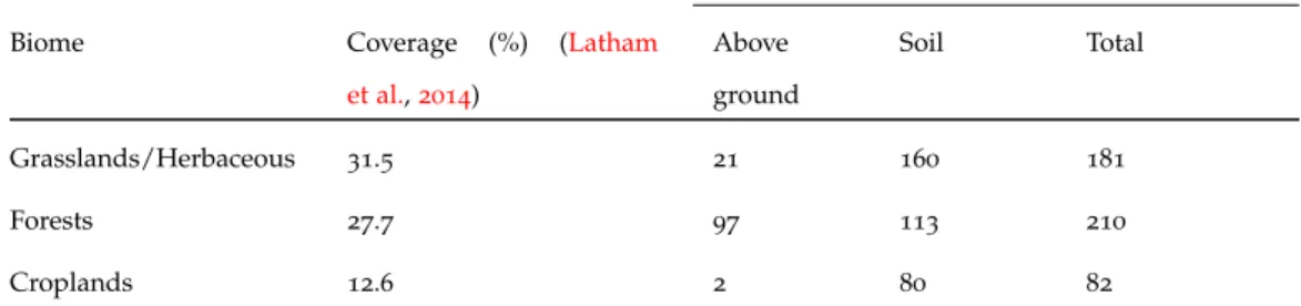
Globally, grasslands are one of the biggest terrestrial ecosystems. With181
Mg/ha, they are the second highest carbon stock after forests (210Mg/ha),
and together, forests, croplands, and grasslands play a crucial role in the
regulation of the global carbon cycle (see Table 1 for details). Land cover
transformations caused by biomass burning and agricultural intensification
contribute significantly to greenhouse gas emissions (Chuvieco,2008).
Table1: Grasslands, forests and croplands global coverage and carbon stocks.
Carbon stocks (Mg/ha) (Franzluebbers,2010)
Biome Coverage (%) (Latham
et al.,2014) Above ground Soil Total Grasslands/Herbaceous 31.5 21 160 181 Forests 27.7 97 113 210 Croplands 12.6 2 80 82
In relation to global greenhouse gas emissions it is very important to monitor the biosphere at a large scale in order to fully understand the impact caused by change in vegetation area and hence biomass amount. Conventional ground-based methods (e. g., rising plate meter, cut and dry, visual assessment) have been used for decades for field or farm scale mon-itoring of grassland biomass. All these methods are very time consuming, laborious and are applicable to a very small scale. A possible solution to these limitations is the use of remote sensing technologies. Remote sensing
1.1 i m p o r ta n c e o f g r a s s l a n d s 5
technologies can be used to monitor ground targets at a regional to global scale on a regular basis. The use of such technologies for biomass estima-tion of different vegetaestima-tion types (grasslands, forests, croplands) has been on-going for many years, and many studies have contributed to the de-velopment of remote sensing methodologies and implementation schemes.
Scientists (e. g., Gordon (1974)) have demonstrated an interest in
satellite-based biomass quantification from the time of the launch of Landsat-1
(orig-inally called "Earth Resource Technology Satellite1") in 1972.
1.1 i m p o r ta n c e o f g r a s s l a n d s
Grasslands are not only important for their wide spread coverage (see
Ta-ble2) but they also play a substantial role in food security and other
ecosys-tem services. Below are highlighted some of the key roles grasslands are playing in our life and environment :
I dairy products constitute a major proportion of our daily intake. In order to meet the global demand for food, especially milk and meat, a sustainable dairy farming system is very important. Globally
grass-lands cover a major proportion (≈31.5%) of the terrestrial land cover of
the Earth’s surface (Latham et al.,2014), as shown inTable2 and their
adaptation to climate changes will be variable (O’Mara, 2012).
Statis-tics show that the area of permanent pasture cover at a global scale is decreasing except in Africa and America, however, in Europe the area
(179Millions of hectares) is quite stable and has been consistent for the
last three decades (FAOSTAT, 2014).
II soil covered by grass has more potential to store carbon than forests
and crops as shown in Table1.
III grasslands are helpful in the struggle against erosion (their leaves in-tercept rainfall and their roots bind the soil) and for the regularizing
of water regimes (Carlier et al., 2009).
IV Borer et al.(2014) has reported that biodiversity across grasslands can be maintained by fertilizing and controlled grazing.
Grassland/pasture is the only crop able to fulfil so many tasks and to fit so many requirements (e. g., environmental, development of the countryside) (Carlier et al., 2009)
Table2: Global status of permanent pastures (in millions of hectares) [Statistics
source: (FAOSTAT, 2014)]. Overall globally pasture cover has decreased
in the last two decades, however, at a continental scale the trends vary for different regions e. g., consistent increase in pasture cover in Africa and America, continuous decrease in Asia and Oceania. For the last three decades pasture cover in Europe is quite stable.
Time period Region 1994 2004 2012 Africa 881 898 904 Asia 1102 1099 1080 Europe 179 180 178 Oceania 435 404 369 America 797 811 827 World 3395 3395 3359
1.2 a g r i c u lt u r e a n d c l i m at e c h a n g e 7
1.2 a g r i c u lt u r e a n d c l i m at e c h a n g e
1.2.1 Global context
"Human influence on the climate system is clear, and recent anthropogenic emis-sions of greenhouse gases are the highest in history. Recent climate changes have had widespread impacts on human and natural systems"(IPCC,2014). Maintain-ing the carbon budget–the estimated amount of carbon dioxide the world can emit while still having a likely chance of limiting global temperature
rise to 2◦C above pre-industrial levels (IPCC, 2014)–is crucial for the
sus-tainable future of planet Earth. 52% of the available estimated global CO2
budget has already been burnt, and if the greenhouse gas (GHG) emissions
continue at the current rate the remaining48% will be used by2045(IPCC,
2014). After consuming half of the carbon budget, the world is already
ex-periencing catastrophic events due to more extreme weather events and climate changes, for example:
• global sea level rise
• forest fires
• heavy precipitation events
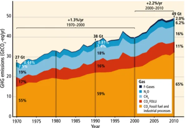
Carbon dioxide constitutes the major proportion of total annual anthro-pogenic GHG emissions by gases, as compared to methane, nitrous oxide
and other gases as shown inFigure1.
Figure1: Total annual anthropogenic GHG emissions by gases 1970–2010 (IPCC,
2014).
With the increase of every degree of warming above 2◦C, modelling
demonstrates that the situation will not improve and that disastrous events will be more frequent in future. For example, if the GHG emissions
con-tinue unabated, global sea levels could be nearly 1 meter higher by 2100
(IPCC,2014). To address these issues policy and decision makers have been
attempting to reach a consensus on the global climate change policy
frame-work. Finally, after20years of hard work, discussions and negotiations, on
1.2 a g r i c u lt u r e a n d c l i m at e c h a n g e 9
climate change pact, the Paris Agreement1
, to reduce greenhouse gas
emis-sions. The aim of the Agreement is described in Article 2, "enhancing the
implementation" of the United Nations Framework Convention on Climate
Change (UNFCCC) through2
(a) "Holding the increase in the global average temperature to well below
2◦C above pre-industrial levels and to pursue efforts to limit the
tem-perature increase to 1.5◦C above pre-industrial levels, recognizing that
this would significantly reduce the risks and impacts of climate change; (b) Increasing the ability to adapt to the adverse impacts of climate change
and foster climate resilience and low greenhouse gas emissions devel-opment, in a manner that does not threaten food production;
(c) Making finance flows consistent with a pathway towards low green-house gas emissions and climate-resilient development."
Countries furthermore aim to reach the global peak of greenhouse gas emis-sions as soon as possible.
Efforts to reduce the emissions are of relevance to the agriculture
sec-tor, as the world population is set to increase from 7.4billion (2016) to 8.9
billion by 2050, and meeting the food requirements for the growing
popu-lation will result in emissions of additional greenhouse gases (particularly methane and nitrous oxide). Growing populations and wealth will increase the global demand for meat and dairy products, and in return the agricul-ture sector will also be impacted by climate change. Events (e. g., flood,
1 http://newsroom.unfccc.int/unfccc-newsroom/finale-cop21/ 2 http://unfccc.int/resource/docs/2015/cop21/eng/l09r01.pdf
drought and changes in precipitation patterns) caused by extreme weather and climate will challenge the worldwide capacity to produce food. In or-der to avoid future humanitarian food crises there is a need to stabilise the concentration of GHG in the atmosphere.
During the Conference of Parties (COP) 21 meeting of the United
Na-tions Framework Convention on Climate Change (UNFCCC) in Paris,
gov-ernments and food and agriculture organizations joined at the Lima-Paris
Action Agenda (LPAA) focus on agriculture to respond to urgent climate
challenges facing agriculture with cooperative initiatives that will protect the long-term livelihood of millions of farmers and reduce greenhouse gas
emissions3
. Globally agriculture is contributing24% of the greenhouse gas
emissions4
and in return it is seriously affected by extreme climates. The following four initiatives were on the agenda list:
i soils in agriculture sector, ii the livestock sector,
iii food losses and waste, and
iv sustainable production methods and resilience of farmers.
The UN Secretary General’s special representative for food security and nutrition Mr. David Nabarro highlighted the potential of these initiatives
for sustainable agricultural development in future: "The time has come to
reshape agriculture but it must be of the right type: regenerative, smallholder cen-tered, focused on food loss and waste, adaptation, soils management, oceans and
3 http://newsroom.unfccc.int/lpaa/agriculture/
1.2 a g r i c u lt u r e a n d c l i m at e c h a n g e 11
livestock". At the Action Agenda, the following six major initiatives sup-porting farmers included:
1. The "4/10005 Initiative: Soils for Food Security and Climate": Officially
launched by a hundred partners, including both developed and de-veloping states, international organizations, private foundations,
non-governmental organizations (NGOs) and farmers’ organizations. By
knowing that soil can store huge amounts of carbon, the aim of the
4/1000initiative is to protect and increase carbon stocks in soils.
2. Live Beef Carbon: Farmers from four European countries took the
ini-tiative to reduce the carbon footprint of the livestock sector. Initially
launched in October 2015, the "Live Beef Carbon" initiative aims at
developing innovative livestock farming systems for sustainable beef farming in order to reduce the contribution of livestock production to
GHG emissions. The end target is to reduce the beef carbon footprint
by 15% over10years in France, Ireland, Italy and Spain.
3. Adaptation for Smallholder Agriculture Programme (ASAP):In order to
in-crease the agricultural production and to reduce agriculture’s carbon
footprint, the International Fund for Agricultural Development (IFAD)
committed to invest in poor smallholder farmers in developing coun-tries.
4. 15 West-African Countries Transitioning to Agro-ecology: With the
sup-port of the World Bank, European Union, and the New Partnership
5 What does "4per1000" mean? A "4%" annual growth rate of the soil carbon stock would
make it possible to stop the present increase in atmospheric CO2. For more details:http:
for African’s Development (NEPAD) of the African Union, this initia-tive is aimed to deliver both adaptation and emission mitigation
ben-efits. It will allow the adoption of agro-ecological practices by25
mil-lion householders by 2025.
5. The "Global Initiative on Food Loss and Waste Reduction – SAVE FOOD":
In order to reduce the global food waste and loss which accounts
for 3.3 Gt of CO2 equivalent per year, this initiative aims to drive
innovations and promote interdisciplinary dialogue to reduce food loss and waste.
Approximately 24% of our greenhouse gas emissions come from
agri-culture (Gilbert, 2012), for example, globally rice crops accounts for 19%
of anthropogenic methane emissions (Chen and Prinn, 2006). Similarly the
agriculture (or grass crop) based dairy sector is also contributing
signif-icantly (2.2 CO2 eq/kg Fat and Protein Corrected Milk (FPCM) at farm
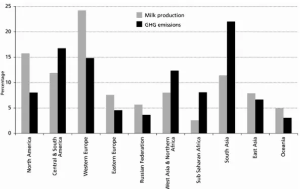
gate) to greenhouse gas emissions. Regions like East Asia, West Asia & North Africa, Central & South America and Sub Saharan Africa are pro-ducing less milk (compared to the developed countries) but generate high GHG emissions due to the poor management (e. g., poor nitrogen fertiliser
management) as shown in Figure 2 (the complete report is available at
1.2 a g r i c u lt u r e a n d c l i m at e c h a n g e 13
Figure2: Relative contribution of world regions to milk production and GHG
emissions associated with milk production, processing and
transporta-tion (source:http://www.fao.org/docrep/012/k7930e/k7930e00.pdf).
1.2.2 Irish context
In the Irish economy agriculture plays a very important role, as
agricul-ture and the Irish food industry provide 230,000 jobs and contribute
ap-proximately e25 billion to the Irish economy (2016 report)6. Most of the
revenue (e10 billion) is generated through the exports of dairy products
and ingredients. Grasslands in Ireland are intensively managed–receiving artificial fertiliser and other treatments such as liming and re-seeding to optimise grass productivity–and are the backbone of the Irish livestock
in-dustry (O’Brien, 2007).
6 http://www.irishexaminer.com/business/growing-potential-of-the-food-industry-\
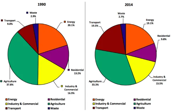
EU member states, including Ireland, are working on short, medium and long term plans to mitigate the effects of climate change by minimizing the
emissions of greenhouse gases (see Figure 3 for GHG emissions by sector
in Ireland). In Ireland the agriculture sector is a major source of
green-house gas emissions. From 1990 (20.83 Mt CO2eq/annum) to 2013 (19.04
MtCO2eq/annum) a significant decrease (8.59%) in emissions is reported
in the agriculture sector7
, while in the case of the transport sector the
per-centage has increased from9.0% to19.5% during this period. Historically it
has been established that there is a strong connection between local climate and local vegetation, and therefore gross changes to local ecosystems are
expected (Prentice et al., 1992). In the case of Ireland, climate change will
result in changes in land use, potentially agricultural land abandonment
in some places and changes from livestock to crops or vice versa (Lennon,
2015).
1.2.2.1 GHG emissions from the agriculture sector
In the Irish agriculture sector the emissions of greenhouse gases are mainly from natural processes but are also due to land cover change. The main
gases are8
:
• Methane from ruminants from the breakdown of plant material
• Methane from stored manure
7 Ireland’s GHG Emission Projections (May 2015 report): https://www.epa.ie/pubs/
reports/air/airemissions/irelandsghgemissions2014-2035.html#.Vrc0HzaLTGI
8 http://www.agriculture.gov.ie/ruralenvironment/climatechangebioenergybiodiversity/
1.2 a g r i c u lt u r e a n d c l i m at e c h a n g e 15
Figure3: Ireland: greenhouse gas emissions in1990and2014by sector (EPA,2014).
• Nitrous oxide from soils
In addition to this,5% ofCO2emission from the agriculture sector is due to
the farm combustion of fuels. From the management perspective, grassland re-seeding or land-use change requires ploughing, which may enhance
car-bon dioxide emissions from soil (Willems et al.,2011).
1.2.2.2 Trends in GHG emissions from agriculture sector
Due to the small industrial base and large dairy exports, Ireland’s major
proportion of total national emissions is from the agricultural sector,
Fig-ure3shows a reduction in GHGemissions in agriculture sector. This
reduc-tion in emissions was mainly due the improvement in efficiency without compromising the production scale and quality.
1.2.2.3 Mitigating GHG emissions from the agriculture sector
Overall the target is to reduce global GHG emissions by50% by2050. Due
the increasing population of the world, and increasing demand for dairy and meat products, it is very difficult to reduce or maintain the level of global agricultural emissions. Ireland’s agriculture system is very well de-veloped and is one of the most technologically advanced and carbon effi-cient systems in the world. However, reforms in greenhouse gas account-ing methods are required for better assessment of agricultural greenhouse
gas emissions (O’Brien et al., 2014). Styles and Jones(2008) have reported
that energy-crop heat production has greater potential to reduce
green-house emission compared to agricultural de-stocking. Nitrous oxide (N2O)
emissions from grassland-based agriculture is an important component of
greenhouse gases and legume based grasslands have lowerN2Oemissions
than fertilizer-based systems.N2Oemissions can be mitigated by reducing
manure nitrogen inputs according to need and by restricting grazing by
reducing grazing time (Li et al., 2013).
1.3 i r i s h a g r i c u lt u r a l t r e n d s
Due to its temperate climate Ireland has suitable grass growing conditions,
including regions (southern part) with a year round growing season (
Fis-cher et al., 2000). Agricultural land makes up about 62% of Ireland’s
ter-restrial area, and80% of this area is grassland. Over time there have been
1.3 i r i s h a g r i c u lt u r a l t r e n d s 17
the significant changes in Irish agricultural trends are listed below (
Kear-ney, 2010):
f a r m s i z e a n d s t r u c t u r e: In the mid1960s, before joining the EU, the
number of farms in Ireland was about 239,000 and by the mid 1970s
this number decreased by4.6% to228,000. According to the Census of
Agriculture, in1991there were170,600farms in Ireland and by end of
2007the number declined to128,200(24.8% decrease). A similar trend
was observed across the European Union. The trend of increasing
farm size is also very consistent, in 1991 an average farm size was
about 26 hectares which was increased by 24.2% to 32.3 hectares in
2007.
l a n d r e n t i n g: An increasing trend in renting agricultural land/farms
is evident in the Irish agricultural system. In1991 21% of total farms
were rented and this percentage was increased to 33% in2007.
l a n d f r a g m e n tat i o n: Over the period of time (1991–2007) a
signifi-cant change in number of parcels–an individual piece of land that can be sold separately–per farm has been reported. The average
num-ber of parcels per farm was3.5in 2007as compared to 1.9parcels in
1991.
pa r t-t i m e f a r m i n g: The trend of part-time farming is increasing in
smaller farming systems (e.g., cattle and sheep farming) due to the increasing trend of getting off-farm jobs. The percentage of part-time
l a n d u s e: Since1970agricultural/crop land has reduced by about24.8%
and most of this land has been diverted to forestry.
l a n d p r i c e s: Before joining the EU in1973, the average agricultural land
price in Ireland was e524 per hectare but subsequently there was a
rapid increase in land prices, for example e4292 per hectare in 1980,
e12665 per hectare in2000ande50508per hectare in 2007.
1.4 m i l k q u o ta – e c o n o m i c va l u e
A milk quota was one of the measures used by governments in the Eu-ropean Union to intervene in agriculture to bring rising milk production under control. Milk quotas were attached to land holdings, and they rep-resented a cap on the amount of milk that a farmer could sell every year
without paying a levy. The introduction of the milk quota in1984was a
ma-jor setback for both the dairy sector and Irish economy, and that was a
diffi-cult time for the Irish agridiffi-culture sector. After more than30years European
Union milk quotas were lifted in March2015. A study by the Irish Farmers
Association (IFA) estimated the ending of quotas would create 9500 extra
jobs in Ireland, and upwards of 1.3 billion Euro annual additional export
revenue (www.independent.ie,2015). But at the same time, optimization of
the carbon footprint of milk and economic output of dairy farms is also
very important for mitigating GHG emissions. O’Brien et al. (2015)
per-formed a detailed analysis by using221 nationally representative samples
1.5 c u r r e n t s i t uat i o n 19
milk to farms’ economic performance. It was concluded that extending the length of the grazing season and increasing milk production per hectare or per cow reduced the carbon footprint and increased farm profit. However, the use of concentrate feeding affected the carbon footprint of milk and economic performance by increasing both costs and off-farm emissions.
1.5 c u r r e n t s i t uat i o n
Food Wise 2025, the Report of the 2025 Agri Food Strategy Committee in
Ireland sets out a cohesive, strategic plan for the development of an agri-food sector over the next decade. The report emphasizes the development of a sustainable export-led, smart economy. On the basis of available data, the Committee believes that the following growth projections are
achiev-able by 2025(FoodWise-2025, 2015)
• Increasing the value of agri-food exports by 85% to e19billion.
• Increasing the value added in the agri-food, fisheries and wood
prod-ucts sector by70% to in excess ofe13billion.
• Increasing the value of primary production by 65% to almost e10
billion.
• The creation of an additional23,000direct jobs in the agri-food sector
all along the supply chain from primary production to high value added product development.
Apart from maximizing the economic output from the farms, at the same time it is also important to protect the ecological aspects of these grassland farms. One of the European Rural Development policy’s objectives is to identify and protect the High Nature Values (HNV) farmland. However, in grass-based farmland (e. g., in Ireland) it is difficult to distinguished be-tween fine-scale biodiversity features of different grassland types. For these type of investigations, field-scale survey work is required along with very high resolution remote sensing and information from Corine Landcover
ClassificationSullivan et al. (2010).
1.6 m o t i vat i o n f o r t h i s w o r k
Almost two-thirds of Ireland’s land cover is grassland, consistent moni-toring of which is of utmost importance in the context of national agri-culture initiatives. For proper management and monitoring more efficient and scientifically reliable models are required for grass growth estimation. Grass-based intensive systems demand constant intervention on a daily and weekly basis by the farmer, and estimation of pasture cover (biomass) is the most important variable in these decisions which play a vital role in
paddock and herd management (Edirisinghe et al., 2012; Clark et al., 2013;
Boschetti et al., 2007).
In addition, EU member states are required to adhere to a growing num-ber of environmental and agricultural directives, and it is essential that individual member states have the independent capacity to provide input
1.6 m o t i vat i o n f o r t h i s w o r k 21
to these. No Earth Observation studies of grasslands have been undertaken in Ireland for grassland biomass estimation. As such, little is known about the spatial, temporal and spectral requirements necessary to develop a na-tional monitoring strategy based on Remote Sensing. Moreover, as agricul-tural environments respond to changing climate conditions (e. g., an earlier start and later finish to the growing season) it is imperative to develop ro-bust approaches which will permit both contemporary and historic capture of the grassland condition.
Currently in Ireland, mostly the farmers are using visual (eye ball),
ris-ing plate meter and cut and dry methods9
to evaluate grass stocks. This is clearly a very time consuming approach and the estimates are also not very
accurate as shown by O’Donovan and Dillon (1999) who compared visual
and mechanical methods. Both visual and rising plate meter methods do
not perform as well as the cutting technique (Pavlu et al.,2009). Grassland
biomass estimations available in the"PastureBaseIreland"database from
Tea-gasc’s10
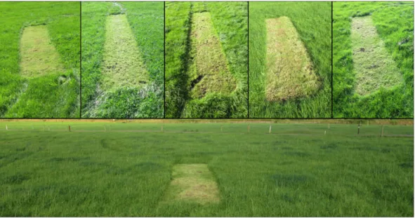
farms (e. g., Moorepark, Curtins, Grange) are determined using the cut and dry method, a strip of approximately three meters long and one
meter wide is clipped and dried to calculate the Dry Matter (DM) kg/ha as
shown in Figure4. "PastureBaseIreland"has very high quality, long term
in-situ measurements of grassland biophysical parameters for some Teagasc farms (e. g., Moorepark, Grange, Curtins), but now more farms are being added to the database (with georeferenced information of geo-referencing)
9 The details of these methods is given in next chapter.
10 Teagasc is the agriculture and food development authority in Ireland. Its mission is to
support science-based innovation in the agri-food sector and the broader bioeconomy that will underpin profitability, competitiveness and sustainability.
in order to increase the number and country wide spatial distribution of these farms.
Figure4: Teagasc grassland biomass estimation method (Photographs were taken
during the Curtins (Teagasc farm) field campaign).
1.7 r e m o t e s e n s i n g t e c h n o l o g y – s c o p e a n d p o t e n t i a l
To feed the growing population of the planet and to avoid food shortage related humanitarian crises, it is very important to monitor crops and agri-cultural activities on a consistent basis. At a global scale, this type of mon-itoring is important for understanding the influence of climate change on vegetation health. At the same time, it is equally important to monitor agricultural fields at the farm and paddock scale in order to assess their production and performance-related biophysical parameters.
1.7 r e m o t e s e n s i n g t e c h n o l o g y – s c o p e a n d p o t e n t i a l 23
Optical satellite imagery is currently being used in the field of
agricul-ture for the discrimination of crop types (e. g., Löw and Duveiller (2014))
and to address more challenging tasks such as calculation of Net Primary
Production (NPP) (Rossini et al., 2012). Knowledge of the spatial
distribu-tion of different agricultural land covers and their annual growth cycle is important, not only for predicting annual yields, but also for accurately cal-culating carbon reserves which are key inputs for international greenhouse
gas accounting tools (Lin et al., 2012).
At present, the remote sensing community is benefiting from advances in technology that are allowing for the acquisition of data with higher spatial, temporal, and spectral resolutions. This influx of big-data from satellites is
giving birth to many new research fields and application domains (
Caval-laro et al., 2015; Ma et al., 2015). In the context of agricultural monitoring,
satellite remote sensing has been employed since the launch of Landsat-1
in 1972. Classification of the land cover types is a typical application of
remote sensing datasets. There is a common consensus that space borne optical remote sensing is a more feasible approach for vegetation
moni-toring than microwave radar remote sensing. This may be due to (1) the
fact that there exists a long history of dedicated investigations, and,
there-fore a wider appreciation of the optical approach; (2) the availability of
the high number of spectral bands, with spectral responses linked to well
understood phenological stages; and (3) the rapid improvement in spatial
resolution. However, with the increasing availability of very high resolution
spaceborne SAR data the trend is now changing. TerraSAR-X Staring
resolution which may revolutionize the monitoring of ground targets from
space (Gutjahr et al., 2015).
Since the dawn of satellite remote sensing, significant advances in tech-nological development have occurred and new applications are
continu-ously being identified. Within the last decade alone (2005-2015), many
new sensors (e. g., SAR: Sentinel-1, ALOS, COSMO-SkyMed, TerraSAR-X,
Radarsat-2, Tandem-X. Optical: Landsat-8, RapidEye, SPOT-7, Sentinel-2,
WorldView) with high spatial, temporal and spectral resolution have been developed and launched. At the same time, a paradigm shift has occurred, whereby we have moved on from simple land cover classification and map-ping to the retrieval of more complex essential biophysical parameters. The rapid and revolutionary development in spatial, temporal and spectral reso-lution has triggered this shift. For example, currently available high spatial
resolution spaceborne optical (e. g., WorldView-3 with a spatial resolution
of1.24m; panchromatic band at0.31m) and SAR (e. g., TerraSAR-X Staring
Spotlight mode has 0.25m spatial resolution) data has great potential to
track inter and intra field variations. With these developments, new state of the art operational decision support systems for various ecosystems have been, and need to be, developed.
Despite the fact that optical remote sensing has great potential in the monitoring and retrieval of vegetation/crop biophysical parameters, a ma-jor drawback of this approach is that it is limited by cloud cover. The microwave radar remote sensing data acquisition technique, on the other hand, is advantageous in that it is possible to acquire data at any time due to the ability of microwaves to penetrate through cloud cover, haze and
1.7 r e m o t e s e n s i n g t e c h n o l o g y – s c o p e a n d p o t e n t i a l 25
dust. While optical sensors can acquire cloud-free data in different regions of the world throughout the year, microwave sensors may be useful in areas with consistent cloud cover (e. g., Northern Europe) where it is not possible to acquire high spatial resolution cloud-free optical data on a regular basis. This is important for precision agriculture or crop monitoring because it is crucial to have a dense and temporally consistent time series in order to trace the plant’s phenological developments.
Studies (Immerzeel et al.,2009;Rocchini,2015) have shown that the
satel-lite remote sensing approach is the most feasible and economical way of monitoring large ecosystems from the local to global scale. This approach has significantly helped scientists to understand the functionality and dy-namics of terrestrial ecosystems. Monitoring and estimation of grassland production are of great importance for animal feed production and cal-culating the national contribution of land cover types to carbon budgets,
including the utilization of space borne satellite data-drivenVI for the
esti-mation of grassland’s biomass.
The techniques of monitoring grasslands and nature conservation sites
from space are now quite mature and widely used. The VI (e. g.,NDVI,
En-hanced Vegetation Index (EVI) and Soil Adjusted Vegetation Index (SAVI))
are being effectively used for agricultural monitoring and crop discrimi-nation in a number of countries, but still their integration with machine learning algorithms/models for grassland biomass estimation is very lim-ited. Climate variables and features extracted from climate data also have a very strong relationship with the growth dynamics of vegetation or plant phenology. Similarly, synergistic use of remote sensing derived parameters
(e. g., NDVI, EVI, SAVI) and features such as GDDderived from climate data have never been tested for grassland biomass retrieval. Work has been done
on the fusion ofVIand GDDfor surface temperature (Hassan and Rahman,
2013) or wetness estimation using linear methods but to the best of our
knowledge the fusion ofVI and GDDfor grassland biomass retrieval using
a machine learning approach has not yet been reported in the literature.
1.8 o b j e c t i v e s
There is a critical need for quantitative spatial and temporal information on agricultural land use at a national scale within Ireland to assist with agricultural monitoring, as an input to national carbon budget reporting requirements, and to inform agri-environmental policy development. The aim of this study is to investigate the capability of retrieving grassland
biomass in an intensively11
managed environment using multi-temporal
space borne optical (2001–2012) and radar (July,2014– July,2015) remote
sensing time series. Specifically, the objectives are to:
1. undertake a detailed state of the art review of published literature in
order to determine the current status of grassland monitoring globally based on satellite remote sensing data
11 The term"intensive"is meant to describe livestock and grass management practices that
focus on increased levels of manager involvement, increased forage quality, increased meat production per unit area, and more uniform forage utilization.
1.9 c h a p t e r ov e r v i e w 27
2. explore the potential application of satellite–driven VI for grassland
biomass estimation for selected Irish sites using a machine learning approach
3. investigate the fusion of VI and GDD in order to analyse the
contri-bution of climate variables for grassland biomass and growth rate estimation at a selected Irish site
4. evaluate the potential and limitations of using repeat-passInSARto
re-trieve grassland biophysical parameters at an Irish site using X-band TerraSAR-X time series
5. make recommendations for the development of a nation wide
opera-tional decision support system
1.9 c h a p t e r ov e r v i e w
c h a p t e r—2: This chapter12 gives a detailed state of the art review of
satellite remote sensing of grasslands. The first part provides a com-prehensive overview of the global presence of grassland and describes the most commonly employed applications of remotely sensed data for classification and mapping. The second part covers the monitoring of managed grasslands’ properties such as growth rate, biomass, pas-ture quality and grazing intensity. Finally, research gaps are identified and potential solutions to these issues suggested.
c h a p t e r—3: In this chapter13 the development of machine learning
mod-els (ANN and ANFIS) for grassland biomass estimation is described.
Their performance is compared with the conventional and most
com-monly used statistical approach, Multiple Linear Regression (MLR).
The chapter also describes how the developed methodology was tested
on two different test sites (Moorepark and Grange) using12years and
6 years time series ofMODIS remote sensing data.
c h a p t e r—4: This chapter14 presents the inclusion of weather data into
the developed model (ANFIS) as a proxy to predict and improve biomass
estimation. The relationship between NDVI and the
minimum/maxi-mum temperature is explained. Our results, which show that fusion
of remote sensing VIand accumulated growing degree-days
tempera-ture has improved the biomass rate and yield estimation performance for the Grange site, are presented.
c h a p t e r—5: This chapter15 investigates the potential of repeat-pass
syn-thetic aperture radar interferometry (InSAR) to retrieve biophysical parameters over intensively managed pastures. It describes initial find-ings based on the highest resolution space borne TerraSAR- X Star-ing Spotlight time series for Moorepark, which demonstrate the pos-sibility, under certain conditions, of detecting changes due to grass growth, grazing and mowing by using interferometric coherence in-formation.
13 Chapter–3title:"Modelling biomass estimation of managed grasslands"
14 Chapter–4 title: "Fusion of remote sensing and weather data to retrieve grassland biomass and
growth rate"
1.9 c h a p t e r ov e r v i e w 29
c h a p t e r—6: The final chapter16 summarizes the general findings of the
present work, and outlines directions for future research.
2
S AT E L L I T E R E M O T E S E N S I N G O F G R A S S L A N D S
Literature is air, and I’m suffocating in mediocrity.
— Armand Assante
c h a p t e r p u b l i c at i o n:
This chapter has been published as a review article in Journal of Plant Ecol-ogy:
Ali, I.; Cawkwell, F.; Dwyer, E.; Barrett, B.; and Green, S.; 2016, "Satellite remote sensing of grasslands: from observation to management—a review", Jour-nal of Plant Ecology, doi:10.1093/jpe/rtw0051. [IF:2.646]
1 Online available at: http://jpe.oxfordjournals.org/content/early/2016/02/02/jpe.
rtw005.abstract?sid=37fbd6ed-e24a-4ce7-9992-8c7457cbced6
32 s at e l l i t e r e m o t e s e n s i n g o f g r a s s l a n d s
2.1 pa p e r—1
2.1.1 Ali, I.;Cawkwell, F.; Dwyer, E.; Barrett, B.; and Green, S.;2016, "Satellite remote sensing of grasslands: from observation to management—a review", Journal of Plant Ecology, doi:10.1093/jpe/rtw005. [IF:2.646]
This state of the art review paper covers the different aspects of the ap-plication of remote sensing technology for retrieval of biophysical param-eters which are used for grassland management related decision making
(for graphical abstract see Figure 5). This review starts with conventional
field methods (e. g., clipping, Rising Plate Meter) used for grassland mon-itoring (e. g., biomass, height and status) and their limitations. In order to overcome these limitations, the use of optical and radar remote sensing approaches are discussed. Due to the widespread presence of grasslands on the terrestrial land cover of the Earth, the global context of grasslands and the applications of remote sensing technologies for large scale moni-toring of grasslands are discussed in this review. The classical application of remote sensing data (i. e., mapping, classification) is discussed and crit-ically analysed. The next part of the review is focused on the application of remote sensing methods to retrieve grassland biomass and management strategies (e. g., grazing impacts, grazing capacity, pasture quality, growth rate and status). Grasslands in Ireland are mainly intensively managed, therefore it is very important to critically evaluate the potential of remote sensing technologies in this context. Operational and technical challenges
of the remote sensing approach to monitoring grasslands are discussed and examples are also given in this context. At the end, this review concludes with some suggestions on current challenges and future directions.
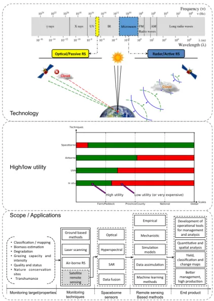
Op#cal/Passive RS Radar/Ac#ve RS Microwave Cloud Cloud Technology High/low utility Scope / Applications Be,er management, high produc6on Ground based methods Air-‐borne RS Machine learning methods Data assimula6on Laser scanning • Classifica6on / mapping • Biomass es6ma6on • Degrada6on
• Grazing capacity and intensity
• Quality and status
• Nature conserva6on sites • Transhumance Empirical Mechanis6c Op6cal Hyperspectral SAR Data fusion Satellite remote sensing Monitoring
techniques Spaceborne sensors
Simula6on models
Monitoring target/properties Remote sensing Based methods End product Yield, classifica6on and change maps Quan6ta6ve and spa6al analysis Development of opera6onal tools for management and analysis
Figure5: Graphical abstract of this review: Ali, I.; Cawkwell, F.; Dwyer, E.;
Barrett, B.; and Green, S.; 2016, "Satellite remote sensing of grasslands: from observation to management—a review", Journal of Plant Ecology, doi:
Declaration of own contribution to the published (or intended for publication) sci-entific papers within my dissertation.
d i s s e r tat i o n t i t l e: Retrieval of grassland biophysical parameters
us-ing multitemporal optical and radar satellite data.
pa p e r–1: Ali, I.; Cawkwell, F.; Dwyer, E.; Barrett, B.; and Green, S.; 2016, "Satellite remote sensing of grasslands: from observation to management—a review", Journal of Plant Ecology, doi:10.1093/jpe/rtw005. [IF:2.646]
o w n c o n t r i b u t i o n i n t h i s w o r k: Concept development (fully),
Lit-erature search (fully), Methods development (fully), Research design (fully), Data collection (mainly), Data pre-processing (fully), Data anal-ysis (fully), Construction of the manuscript (fully), Argumentation (fully), Critical revision of the article (mainly).
Iftikhar Ali, MSC
April17, 2016
© The Author 2016. Published by Oxford University Press on behalf of the Institute of Botany, Chinese Academy of Sciences and the Botanical Society of China. All rights reserved. For permissions, please email: journals.permissions@oup.com1
Satellite remote sensing of grasslands: from observation to management–a review
Iftikhar Ali1,*, Fiona Cawkwell1, Edward Dwyer2, Brian Barrett3 and Stuart Green4 1
Department of Geography, University College Cork, Cork, Ireland
2EurOcean - European Centre for Information on Marine Science and Technology, Lisbon,
Portugal 3
School of Geographical and Earth Sciences, University of Glasgow, Glasgow, UK 4Spatial Analysis Unit, Teagasc, Dublin, Ireland
*
Correspondence address. E-mail: iffi.math@gmail.com
Abstract
Aims
Grasslands are the world’s most extensive terrestrial ecosystem, and are a major feed source for livestock. Meeting increasing demand for meat and other dairy products in a sustainable manner is a big challenge. At a field scale, GPS and ground based sensor technologies provide promising tools for grassland and herd management with high precision. With the growth in availability of spaceborne remote sensing data it is therefore important to revisit the relevant methods and applications that can exploit this imagery. In this article we have reviewed the (1) current status of grassland monitoring/observation methods and applications based on satellite remote sensing data, (2) the technological and methodological developments to retrieve different grassland biophysical parameters and management characteristics (i.e., degradation, grazing intensity), and (3) identified the key remaining challenges and some new upcoming trends for future development.
Important Findings
The retrieval of grassland biophysical parameters have evolved in recent years from classical regression analysis to more complex, efficient and robust modelling approaches, driven by satellite data, and are likely to continue to be the most robust method for deriving
at University College Cork on April 9, 2016
http://jpe.oxfordjournals.org/
Downloaded from
2
grassland information, however these require more high quality calibration and validation data.We found that the hypertemporal satellite data are widely used for time series generation, and particularly to overcome cloud contamination issues, but the current low spatial resolution of these instruments precludes their use for field-scale application in many countries. This trend may change with the current rise in launch of satellite constellations, such as RapidEye, Sentinel-2 and even the microsatellites such as those operated by Skybox Imaging. Microwave imagery has not been widely used for grassland applications, and a better understanding of the backscatter behaviour from different phenological stages is needed for more reliable products in cloudy regions. The development of hyperspectral satellite instrumentation and analytical methods will help for more detailed discrimination of habitat types, and the development of tools for greater end-user operation.
Keywords:remote sensing; agricultural grassland; grassland biomass; pasture management; grazing intensity
BACKGROUND Global grasslands
Grasslands are one of the most prevalent and widespread land cover vegetation types, covering 31.5% of the global landmass (Latham et al., 2014). After forests, grasslands are the largest terrestrial carbon sink (Anderson, 1991; Derner and Schuman, 2007) and, as such, they play a vital role in regulating the global carbon cycle(Franzluebbers, 2010; Scurlock and Hall, 1998), as well as supporting plant and animal biodiversity(Bergman et al., 2008; Pokluda et al., 2012; Punjabi et al., 2013; van Swaay, 2002). From an agricultural perspective, grasslands provide the cheapest feed source for the livestock industry, however they contribute both directly and indirectly to climate change through the emission of greenhouse gases (FAO, 2014). As a result, a restriction on a maximum level of grassland intensification (animal stocking) is required in order to minimize the environmental risks
at University College Cork on April 9, 2016
http://jpe.oxfordjournals.org/
Downloaded from
![Table 2: Global status of permanent pastures (in millions of hectares) [Statistics source: (FAOSTAT, 2014 )]](https://thumb-us.123doks.com/thumbv2/123dok_us/11077723.2993973/37.892.165.693.809.1034/table-global-permanent-pastures-millions-hectares-statistics-faostat.webp)