Understanding relations between pastoralism
and its changing natural environment
Understanding relations between
pastoralism and its changing natural
environment
Charles Tamou
Thesis committee Promotor
Prof. Dr I.J.M. de Boer
Professor of Animal Production Systems Wageningen University & Research Co-promotors
Dr S.J. Oosting
Associate professor, Animal Production Systems Group Wageningen University & Research
Dr R. Ripoll Bosch
Researcher, Animal Production Systems Group Wageningen University & Research
Prof. Dr I. Youssao Aboudou Karim,
Professor of Animal Genetics, Polytechnic School of Animal Production and Health University of Abomey-Calavi
Other members
Prof. Dr J.W.M. van Dijk, Wageningen University & Research Dr I.M.A. Heitkonig, Wageningen University & Research Dr M.A. Slingerland, Wageningen University & Research Dr A. Ayantunde, ILRI, Burkina Faso
This research was conducted under the auspices of the Graduate School of Wageningen Institute of Animal Sciences (WIAS)
Understanding relations between
pastoralism and its changing natural
environment
Charles Tamou
Thesis
submitted in fulfilment of the requirements for the degree of doctor at Wageningen University
by the authority of the Rector Magnificus, Prof. Dr A.P.J. Mol,
in the presence of the
Thesis Committee appointed by the Academic Board to be defended in public
on Monday 12 June 2017
Tamou, Charles
Understanding relations between pastoralism and its changing natural environment 164 pages.
PhD thesis, Wageningen University, Wageningen, the Netherlands (2017) With references, with summaries in English and Dutch
ISBN 978-94-6343-155-2 DOI 10.18174/411051
To
Aisha, the little girl who requested me to pledge the case of the Gah-Béri village from being displaced or burnt by the neighbouring crop farmers of Isséné village, following tension between the two communities in June 2014.
Abstract
The competition for land has become an issue of major concern and cause of conflict, especially between pastoralists and crop farmers, but also between pastoralists and nature conservation institutions. The Biosphere Reserve of W in Benin Republic (WBR) and its surrounding lands are located in the agro-pastoral contact zone in West Africa, enabling competition for land, and affecting the relations between pastoralism and its environment. The general aim of this thesis, therefore, was to understand the relations between pastoralism and its changing natural environment. In terms of land use change, cropland area around WBR expanded, whereas grazing area reduced. Population growth and rising demand for food crops and cash crops were the indirect causes of this loss of grazing lands. Competing claims over land existed between crop farmers and pastoralists, among crop farmers, and among crop farmers, pastoralists, and the WBR authority due to past expropriation, unfair and incomplete implementation of the WBR regulations and the increasing shift of pastoral lifestyle to crop farming. In terms of effects of grazing on plant communities, highly grazed sites had more species diversity than lowly grazed sites. This suggests that the current level of grazing was not damaging plant communities’ diversity. Annual species dominated the surveyed vegetation, suggesting that restoration of grazing lands with perennials requires human intervention. Herding involves taking decisions and moving of livestock in search for feed. Herding decisions are based on traditional ecological knowledge (TEK) of soil, forage and livestock. Pastoralists identified five different soils, which they selected for herding at different times of the year. Perennial grasses were perceived of high nutritional quality, whereas annuals were of low nutritional quality. Afzelia africana had high perceived quality for milk production, whereas Khaya senegalensis had the highest perceived quality for meat production, health and strength. In decision making for herding, pastoralists used a holistic approach, combining TEK about soil, vegetation and livestock, in a structured and prioritised reasoning. Changes in the pastoral system can lead to changes in desired livestock traits, which may lead to loss of indigenous breeds. Keteeji was valued for its endurance and tolerance to trypanosomiasis, Bodeeji was highly valued for endurance and Gudali was perceived of high value for meat and milk production, but of low value for endurance. To deal with the changing and unfavourable conditions of their environment, pastoralists preferred cattle breeds performing well on adaptive traits i.e. withstanding hunger, intelligence, and withstanding disease. Our results suggest that pastoralism is under pressure and that its survival depends on policies. In the pessimistic scenario, i.e. without any change, pastoralists will use, likely, the stepping-out strategy in the future. In the optimistic scenario, two possible institutional interventions could help maintaining pastoralism in the region: payments for ecosystem services provided by pastoralism, and association of pastoralism with nature conservation. In practice, however, the implementation of these two interventions is very challenging, which implies an increasing vulnerability of pastoralists and pastoral lifestyle.
Table of contents
Chapter 1 General Introduction 1
Chapter 2 Pastoralists in a changing environment: the competition for grazing land in and around the W Biosphere Reserve, Benin Republic 15 Chapter 3 Effect of grazing on aboveground vegetation and soil seed banks in
the W Biosphere Reserve, Benin Republic 39 Chapter 4 Traditional ecological knowledge underlying herding decisions
of pastoralists 69
Chapter 5 Understanding roles and functions of cattle breeds for pastoralists in
Benin 91
Chapter 6 General Discussion 109
Summary 127
References 131 Samenvatting 143 Acknowledgements 148
About the author 151
Publication list 152
Chapter 1
General Introduction
Chapter 1
2
1.1 Background
Pastoralism is characterised by the movement of herds, in search for feed and water. It, therefore, has three components: people, livestock and natural pastures. Pastoralism is a predominant livelihood in less favoured landscapes, such as drylands, mountains and cold areas, where natural pastures are a primary resource. Drylands are traditionally used and managed by pastoralists, and host nearly one third of the world’s human population and about half of the world’s livestock (Boval et al., 2016; McDermott et al., 2010). The landscapes used by pastoralists are often less suitable for crop production. Drylands are regions of the world with an Aridity Index (i.e., the ratio of mean annual precipitation to mean annual potential evapotranspiration) below 0.65 (Safriel and Adeel, 2005). The climate in dryland regions, for example, is characterised by unpredictable droughts, and highly variable rainfall (Behnke et al., 1993; Whitford, 2002), with often poor soils (Penning de Vries et al., 1980). As a consequence, crop production is difficult and the availability of pasture resources is highly variable across time and space (Scoones, 1995). Mobility enables pastoralists to exploit this variability in pasture resources across time and space (Behnke et al., 1993; Mortimore, 2010). Pastoralism, therefore, is considered a well-adapted production system in the harsh dryland environment (Behnke et al., 1993). Moreover, livestock grazing is an efficient and reliable way to turn sunlight via vegetation and livestock into human food in the extreme and variable dryland environments (Reid et al., 2008).
Pastoralism takes diverse forms, depending on the location, the degree of livestock mobility, and the gender, ethnicity and wealth of the pastoralist (Ayantunde et al., 2011; Fratkin and Mearns, 2003; Moritz et al., 2009). Depending on the degree of livestock mobility, pastoralism is classified into four main categories: First, there is
nomadic pastoralism, which is characterised by constant movement of the herds.
Nomadism is for example found in Sudan and Saudi Arabia (Blench, 2001). According to Blench (2001), nomadic pastoralists are exclusive livestock keepers, who grow no crops and simply depend on the sale or exchange of animals and their products to obtain foodstuffs. Second, there is transhumant pastoralism, which involves seasonal (regular or irregular) movement of the herds between well-defined territories. Transhumance is the predominant form of pastoralism in West Africa (Slingerland, 2000; Thébaud and Batterbury, 2001). Transhumant pastoralists often
General Introduction
3 have a permanent homestead, at which the older members of the community stay throughout the year. Transhumance is associated also with crops production, although primarily aimed at the herders’ own use rather than the market (Blench, 2001). Third, there is transterminant pastoralism, which is characterised by short distance of (daily) movement by settled pastoralists. Transterminant pastoralism is wide spread and generally found in Mediterranean regions (González Álvarez, 2013). And fourth, there is agro-pastoralism, a mixed crop-livestock system with small herd sizes, which are insufficient to sustain the needs of the households. Agro-pastoralists’ subsistence, therefore, is dependent on crop cultivation, providing more than 50% of the income. In agro-pastoralism, livestock moves in the vicinity of the farms and grazes on communal grazing lands, roadsides, and crop fields after harvest. Some scientists do not consider this fourth category as a form of pastoralism (Ayantunde et al., 2011; Swift, 1988; FAO, 2001), whereas others do (Moritz, 2003; Chang and Koster, 1994) since it involves livestock movement, no matter the size of the herd.
As a livestock production system, pastoralism involves the management, herding and care of domestic animals; generally ruminants, such as cattle, sheep, goats, camels, donkeys, yaks and llamas. Pastoralists keep about 35% of the world’s sheep, 23% of the goats, and 16% of the cattle and water buffalos. More than half of the world’s pastoralists are found in Africa (55%), followed by Asia (20%), the Americas (15%) and Australia (10%) (Child et al., 1984). Products directly derived from pastoralists’ herds are milk, meat and hides. In developing countries, with a pastoral-based economy, pastoralism contributes significantly to the agricultural gross domestic product (GDP), e.g. 80% in Sudan, 84% in Niger, 30% in Mongolia (Davies and Hatfield, 2007), and, on average, 5.9% in Benin, between 1995 and 2005 (MAEP, 2011). Pastoralists also contribute indirectly to the economy. Their activities vitalise local economies and result in employment for others. The pastoral system also supplies livestock markets with bulls, oxen, cows and small ruminants. Around livestock markets, other small businesses flourish, such as sale of food (by women), fodder, small equipment for crop farming, veterinary products, and use of trucks to transport livestock to those markets or even sale of bicycles and motorbikes. In addition, the local administration collect tax from livestock markets to support the budget of their municipality (e.g. in Benin, West Africa) (Tamou, 2011). Indirect products and services derived from pastoralists’ activities are manure for crop
Chapter 1
4
fertilisation and draught animals for ploughing and for transport in crop production. Moreover, pastoralism may also contribute to tourism and nature conservation, in terms of rangelands, and ecosystem processes and services that are enhanced or maintained by pastoralism (Davies and Hatfield, 2007).
With 55% of the world’s pastoralists living there, Africa is the most important continent for pastoralism. The arid and semi-arid zones of sub-Saharan Africa account for 55% of the continent’s area and hold 57% of domestic ruminants (Rutherford et al., 2006). In sub-Saharan Africa, about 25 million pastoralists and 240 million agro-pastoralists rely on livestock grazing for their livelihoods (Neely et al., 2009). According to the ruminant livestock association, the pastoral system in Benin involves more than 300,000 pastoralists (ANOPER, 2014). Livestock produced from the pastoral system plays an important role in the economy of these countries. For instance, between 1970 and 2000, livestock trade increased from USD 13 to 150 million in West Africa (Nugteren and Le Côme, 2016). Between 2009 and 2012, Nugteren and Le Côme (2016) reported USD 451 million as the total revenue of trade of pastoral livestock in both Mali and Burkina Faso. In Benin, according to (FAOSTAT, 2017), the gross production value of live cattle, sheep and goat, was estimated to be USD 100 million in 2013.
1.2 Pastoralism as a knowledge system
In the pastoral system, herders and their livestock access the resources of landscapes, by moving from one place to another. This mobility requires pastoralists to have a broad knowledge about soils, forages, livestock, climatic conditions and their interactions, as well as about social institutions. Pastoralism, therefore, is not only a livestock-based livelihood strategy, but also a recognized lifestyle with socio-cultural norms, beliefs and values, and traditional knowledge revolving around livestock (Davies et al., 2010; Niamir-Fuller, 1999). Through many years of experience in their environment, pastoralists have developed extensive knowledge, that guides a sustainable use and management of their surrounding resources (Blench, 2001). Such knowledge, referred to as traditional ecological knowledge (TEK), is defined as the cumulative body of knowledge, practices, and beliefs regarding the relations of living things to their environment, that evolves by adaptive processes, and is handed down through generations (Berkes et al., 2000). TEK of pastoralists in Africa has been extensively studied. Some studies showed pastoralists’ TEK related to grassland
General Introduction
5 degradation (Admasu et al., 2010; Behmanesh et al., 2015; Kassahun et al., 2008; Roba and Oba, 2009), others reported knowledge of grassland quality (Dabasso et al., 2012; Oba and Kaitira, 2006), or of botanic species diversity and their palatability for livestock (Ayantunde et al., 2008a; Davis, 2005; Oba and Kaitira, 2006). However, few studies attempt to integrate all this knowledge with regard to pastoralism. It is currently acknowledged that pastoralists’ TEK is essential in preserving pastoralism and its cultural heritage. Moreover, policies and interventions related to range- and grassland use could benefit from understanding the TEK of pastoralists (Fratkin and Mearns, 2003).
Pastoralists not only have TEK about rangelands and their use, but also about their indigenous breeds. In the harsh environment of the drylands, pastoralists strive to produce from well adapted indigenous breeds. Pastoralists, therefore, contribute to maintaining animal genetic resources (Köhler-Rollefson et al., 2009; Hoffmann, 2011). In situ conservation of animal genetic resources builds on pastoralists, who are considered the creators and guardians of African livestock breeds (FAO, 2009; Köhler-Rollefson et al., 2009). Pastoralists have developed their indigenous breeds and have knowledge about these breeds. Within their own production systems, especially where environmental conditions are harsh, indigenous breeds are better than exogenous breeds, because of other qualities besides milk and meat production, such as resistance to trypanosomiasis or adaptation to heat stress (Anderson, 2003; Köhler-Rollefson et al., 2009; Ayalew et al., 2003).
1.3 Competing claims for lands
Competition for natural resources, especially land, has become an issue of major concern and cause of conflict (De Haan et al., 2016; Young et al., 2016), especially between pastoralists and crop farmers (De Haan et al., 2016; Fratkin and Mearns, 2003). Around the world, one of the major changes in dryland regions is the expansion of crop farming into drier areas over the last few decennia, which has pushed herders out of much of the wettest, most productive grazing lands over time (Reid et al., 2008). Such expansion of croplands occurs in the Guinean savannah zone of West Africa (MEA, 2005). Several forces (e.g. demographic, socio-economic, political, technological, cultural and/or biophysical) are driving this crop expansion and are consequently negatively affecting availability of and accessibility to pastoral resources in Africa (Reid et al., 2004). About 35 to 50% of the wetter (semi-arid and
Chapter 1
6
dry sub-humid) portions of former grazing lands are now ploughed for irrigated and rainfed crops, and about 2 to 4% of the former grazing lands are now used for towns and cities (MEA, 2005). In Africa, croplands increased by 46 million hectares between 1985 and 2005, at the expense of natural vegetation and grazing lands (Foley et al., 2011). This trend of crop expansion into former grazing land continues today (Clerici et al., 2007). The encroachment of arable farming in pastoral ecosystems has led to a loss and fragmentation of pastoral lands, watering points and livestock routes (Reid et al., 2004).
Pastoralists not only compete for land with crop farmers, but also with nature conservation institutions (Reid et al., 2004). Nature conservation generally builds on protected areas. Original grazing lands of the Maasai, for example, have turned into nature reserves, such as the Maasai Mara and the Samburu National Park in Kenya, and the Serengeti National Park in Tanzania. Creation of these protected areas has reserved grazing lands for exclusive use by native biota (Fratkin and Mearns, 2003). Access to protected areas for grazing by domestic livestock, therefore, is illegal. However, due to shortage of feed and water (in the dry season) and to avoid damage to crop farms (in the rainy season), livestock move into protected areas. This has been seen in the Transfrontier Parks in Southern Africa (Murwira et al., 2012) and in the complex of the W-Arly-Pendjari in West Africa (Bouché et al., 2012; Convers et al., 2007).
1.4 Problem statement
The competition for natural resources, especially land, has become an issue of major concern and cause of conflict (De Haan et al., 2016; Young et al., 2016), especially between pastoralists and crop farmers (De Haan et al., 2016; Fratkin and Mearns, 2003), but also between pastoralists and nature conservation institutions (Reid et al., 2004). Governments and international development agencies have usually neglected pastoral populations and supported them with poorly designed interventions (De Haan et al., 2016). The FAO (2016) acknowledged that “pastoralists have traditionally suffered from poor understanding, marginalization and exclusion from dialogue”. The encroachment of arable farming in pastoral ecosystems has led to a loss and fragmentation of pastoral lands, watering points and livestock routes (Reid et al., 2004). Hence, the mobile strategy used to sustain pastoral production in the drylands is being constrained (Thébaud and Batterbury, 2001; Ayantunde et al.,
General Introduction
7 2008b). As a result, pastoralists are nowadays perceived as burden rather than support for larger societies (Leloup, 2006).
Pastoralism has been held responsible for rangeland degradation due to continuous grazing (Harris, 2010), which is in line with Garret Hardin's theory of the “tragedy of the commons” (Hardin, 1968). Rangeland degradation is defined as a decrease in plant species diversity, plant height, vegetation cover, and plant productivity (Ho and Azadi, 2010). This rangeland degradation can result in the reduction of palatable plant species, an increase in undesirable and unpalatable plants, and a depletion of soil quality (Mekuria et al., 2007). It is reported that about 31% of Africa’s pastures has been degraded (UNEP, 2008). Policies governing pastoralism and common opinions about grassland use have been influenced by Hardin’s theory. To prevent possible overgrazing, governments initiated policies i.e. to privatise grasslands and to sedentarise pastoralists in order to limit the livestock pressure on grasslands. However, such measures have not always yielded satisfactory results and have often resulted in negative or disastrous consequences (De Haan et al., 2016; Fratkin and Mearns, 2003). On the one hand, sedentarisation resulted often in grassland being turned into croplands or in increased stocking rates with negative effects on plant communities (Ayantunde et al., 2011). On the other hand, it is questioned whether pastoralism can really be blamed for overgrazing and grassland deterioration. According to the intermediate disturbance hypothesis (IDH) (Connell, 1978), for example, certain grazing intensity could actually favour plant biodiversity, implying that pastoralism can play a synergetic role in rangeland and nature conservation. Milchunas et al. (1988), in an extended IDH, observed that it is not only grazing intensity that affects plant communities, but also gradients in precipitation and the evolutionary history of grazing. At the far end, the disequilibrium theory (Behnke et al., 1993) states that pastoral ecosystems in drylands are largely controlled by climatic variability and not so much by livestock. Hence, grazing and animal numbers are determined by grass productivity and have no causal effect on long term grass productivity (Behnke et al., 1993).
It is acknowledged that pastoralists possess detailed TEK about their grazing landscape, influenced and enhanced by such grazing landscapes. However, an important challenge for pastoralists is the loss and fragmentation of pastoral resources (Reid et al., 2004), which may change pastoralism. Changes in the pastoral
Chapter 1
8
system and in pastoral lifestyle can therefore affects such TEK, and even result in loss of TEK. TEK of pastoralists in Africa has been extensively studied. Some studies focused on knowledge related to grassland degradation (Behmanesh et al., 2015; Kassahun et al., 2008; Roba and Oba, 2009), others on knowledge of grassland quality (Dabasso et al., 2012; Oba and Kaitira, 2006), or of botanic species diversity and their palatability for livestock (Ayantunde et al., 2008a; Davis, 2005; Oba and Kaitira, 2006). To our knowledge, TEK underlying herding decisions and the use of their grazing landscape by pastoralists have not been reported.
TEK does not only revolve about the grazing landscape, but also about the local animal breeds that can thrive in these harsh environments and make use of the grazing resources. Animal genetic resources (AnGR) are an essential part of the biological basis for world food security, and contribute to the livelihoods of over a billion people (FAO, 2007). At present, however, AnGR are being eroded, as a result of changes in agricultural practices, and in economic and environmental circumstances (Gibson et al., 2006). In situ conservation of AnGR in Africa builds on pastoralists, which are considered the creators and guardians of African livestock breeds, especially ruminants, such as cattle, sheep, goats, and camels (FAO, 2009; Köhler-Rollefson et al., 2009). At present, pastoralists’ culture and lifestyle, however, is threatened, and consequently also their traditional way of herding (Catley et al., 2013; Thornton, 2010). Changes in pastoral life can lead to changes in desired traits, which may lead to loss of indigenous breeds (Hoffmann, 2010). This loss might compromise livelihoods of pastoralists and future improvement of their production systems (Van der Zijpp, 2011).
1.5 Aim of this thesis
The general aim of the study was “to understand relations between pastoralism and its changing natural environment”. To this end, I studied the W Biosphere Reserve (WBR) in northern Benin, where all issues and concerns presented in the previous sections occur.
1.6 Context and description of the W Biosphere Reserve
The WBR and its surrounding land are located in the so-called agro-pastoral contact zone in West Africa (De Haan et al., 1990), implying that land is suitable for crop farming and pastoralism, potentially enabling competition for land. In, and especially
General Introduction
9 in the periphery of the Biosphere Reserve of W in Benin Republic (WBR), some studies report an ongoing trend of land use change from a natural land cover (i.e. forest and savannah) to cropland (Avakoudjo et al., 2014; Clerici et al., 2007; Houessou et al., 2013). These studies focus on the regression of natural vegetation and the expansion of cropland, but little is said about the habitats and resources for pastoralists. The encroachment of arable farming in pastoral ecosystems has forced pastoralists to search for other grazing areas and eventually resulted in illegal grazing inside the reserve (Convers et al., 2007). As in several African countries, policies governing pastoralism in this area are still influenced by Hardin’s theory (Hardin, 1968). The viewpoint and consequences for pastoralists seem to be ignored. A sustainable land use policy for area requires understanding the dynamics in land use and land use change, and providing voice to all actors involved, especially pastoralists. In this thesis, pastoralists involved in the study were either transterminant pastoralists, transhumant pastoralists, or both.
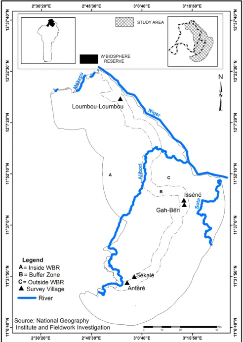
The name “W” originates from the W shape of the Niger River that borders the northern section of the Reserve (in Benin Republic). The WBR comprises about 56% of the W Transboundary Biosphere Reserve located in the countries of Benin, Niger and Burkina Faso, and covers about 5 632 km2 (see Figure 1). The WBR is located at 11º 26’ to 12º 26’ N and 2º17’ to 3º 05’ E. The natural vegetation consists of tree, shrub and woodland savannah, gallery forest and wetland. This vegetation allows the presence of wildlife valuable for conservation purposes, such as lions, cheetahs, elephants, buffaloes, waterbucks, monkeys and birds. The regional water supply comes from the Niger River and its tributaries: the Alibori, Mekrou, and Sota watercourses. The overall area is characterised by two main seasons: a rainy season from mid-May to October, with an average minimum daily temperature of 12 ºC, an average maximum daily temperature of 25 ºC, and precipitation ranging from 700 to 1 000 mm; and a dry season from November to mid-May, with an average minimum daily temperature of 30 ºC, an average maximum daily temperature of 40 ºC and hardly any precipitation (Billand et al., 2005).
Chapter 1
10
Figure 1. The W Biosphere Reserve (WBR) in Benin (small inset map left top corner), the study area relative to the Beninese section of the WBR (small inset map right top corner) and the study area. Villages Sékalé (crop farmers) and Antéré (pastoralists) are in the southern agro-ecological zone, villages Isséné (crop farmers) and Gah-Béri (pastoralists) are in the mid agro-ecological zone and village Loumbou-Loumbou (crop farmers and pastoralists) is in the northern agro-ecological zone
General Introduction
11 During the first part of the dry season, from November to February, a dry dusty wind blows through the North of Benin, also referred to as harmattan, which boosts the drying process of natural pastures. The harmattan facilitates burning of dried pasture, either from controlled or uncontrolled bush fire.
In Benin, the WBR is bordered by five districts, with a total of 759 300 inhabitants (INSAE, 2013). In these districts, the main economic activities are crop farming and livestock production. Crop farmers get their main income from production of cereals (maize, sorghum, millet, rice), roots and tubers (yam, cassava, potato and sweet potato), legumes (groundnut, beans, soybean and bambara bean), vegetables (tomato, pepper, okra, pumpkin) and cotton, and possess oxen for ploughing. They belong to the following ethnic groups: Baatonu, Dendi, Monkole and Goumantche. In contrast, pastoralists obtain their main income from livestock and livestock products, and belong to the Fulbe ethnic group. The Fulbe pastoralists are dwellers of the districts surrounding the WBR and some of them come from the bordering countries Burkina Faso, Niger and Nigeria, during the dry season (Tamou, 2002). In this thesis, I refer to pastoralists as either transhumant pastoralists or transterminant pastoralists, or both
To prevent illegal activities in the WBR, such as clearing for cropping, grazing by livestock, poaching and fishing, rangers are hired and trained for patrolling inside the WBR. To engage the surrounding people in the co-management of the WBR, the
Association Villageoise de Gestion des Réserves de Faune (AVIGREF; in English,
Village Association of Wildlife Management) has been set in the bordering villages. Members of the AVIGREF are often former poachers and current crop farmers now engaged in the co-management of the WBR, by for example informing the authorities on illegal activities. AVIGREF members receive game meat and subsidies after each season of hunting and tourism.
1.7 Thesis outline
The aim of this thesis is to understand the relations between pastoralism and its changing natural environment in and around the W Biosphere Reserve (WBR) in northern Benin. The first step towards understanding these relations is to understand drivers of land use change and competition for land in and around the WBR. The aim of chapter 2, therefore, was i) to describe and analyse land use
Chapter 1
12
changes in order to understand their drivers, and ii) to describe and analyse the viewpoints of relevant stakeholders in order to understand the competition for land in and around the WBR. Data were collected from geographic information system tools, regional statistics, and community meetings and surveys with pastoralists, crop farmers and rangers of the WBR authority.
Subsequently, to understand pastoralism impact on plant communities, I assessed in chapter 3 the effect of grazing and its intensity on the plant community diversity; to our knowledge, this is unknown. The aim of chapter 3, therefore, was to evaluate whether the present grazing regime in the bordering of and inside the WBR affects plant community diversity by addressing the following objectives i) to assess the effect of grazing intensity on plant community diversity in the aboveground vegetation; ii) to assess the effect of grazing intensity on seed abundance and species diversity in the soil seed bank; iii) to assess the effect of grazing intensity on similarity of species prevalence between aboveground vegetation and soil seed bank. We performed a plant inventory for the aboveground vegetation for sites with low and high grazing intensities, in eight sampling sites. A pot experiment with a randomized block design was used to study seed germination of the upper and deeper soil layers of soil seed banks collected at the same sites.
Herding is moving and grazing of livestock, in the grazing landscape consisting of soils, forages and livestock. Herding decisions are based on assessment of soil characteristics, forage characteristics and livestock characteristics. Understanding how such characteristics relate to location and moment of herding may give insight into how pastoralists use natural resources and may give scope for sustainable land use planning and grassland conservation. Chapter 4, therefore, had the following objectives: i) to inventorise and assess how pastoralists characterise quality of soils and forages in their environment, ii) to analyse how soil, forage and livestock characteristics relate to herding decisions and iii) to determine whether TEK underlying herding decisions differs across generations. Data were collected through rapid rural appraisals, focus groups and individual interviews with 72 pastoralists, belonging to three generations and three agro-ecological zones.
Finally, pastoralism is facing the loss and fragmentation of grazing lands, which might affect their production system. Changes in the pastoral system can lead to changes in desired traits, which may lead to loss of indigenous breeds.
General Introduction
13 Understanding pastoralists’ perception of their indigenous breeds and their associated desired traits is of importance in order to prevent loss of livestock diversity, and to improve future production systems. The objectives of chapter 5 were: i) to inventorise indigenous breeds of cattle and their traits, ii) to analyse pastoralists’ preference for breeds and associated reasons, and iii) to determine whether knowledge about breed traits is existent in the younger generations. Data were collected through rapid rural appraisals, focus groups and individual interviews with 72 pastoralists, belonging to three generations and three agro-ecological zones.
Chapter 2
Pastoralists in a changing environment: the competition for grazing land in and around the W Biosphere Reserve, Benin Republic
Tamou C, Ripoll Bosch R, de Boer IJM, Oosting SJ
Cotton farm inside the WBR
Chapter 2
16
Abstract
Pastoralists face increasing competition for land with crop farmers and nature in and around the W Biosphere Reserve (WBR) in Benin. Our aim was to describe and analyse land use changes to understand their drivers, and to describe and analyse the viewpoints of relevant stakeholders to understand the competition for land. We collected quantitative and qualitative data about land use. Cropland area around WBR expanded, whereas grazing land area reduced. Population growth and rising demand for food crops, and government support to the cotton sector were indirect causes of grazing land reduction. Competing claims over land existed between crop farmers and pastoralists, among crop farmers, and among crop farmers, pastoralists, and WBR authorities based on past expropriation, unfair and incomplete implementation of the WBR regulations and the shifting lifestyle of pastoralists. Pastoralism is under so much threat that its survival depends on policies to protect grazing lands.
Key-words: competing claims, land use change, drivers, pastoralism, crop production, nature conservation
Pastoralists in a changing environment
17
2.1 Introduction
Drylands host nearly one third of world’s population, about half of the world’s livestock and are traditionally used and managed by pastoralists (Boval et al., 2017; McDermott et al., 2010). In sub-Saharan Africa, for example, about 25 million pastoralists and 240 million agro-pastoralists rely on livestock grazing on drylands for their livelihoods (Neely et al., 2009).
Dryland ecosystems are characterised by unpredictable droughts, erratic and highly variable rainfall (Behnke et al., 1993) and often poor soils (Penning de Vries et al., 1980). In consequence, the availability of pasture resources is highly variable across time (seasons) and space (Scoones, 1995). Mobility enables pastoralists to exploit this variability in pasture resources across time and space (Behnke et al., 1993; Mortimore, 2010). Pastoralism, however, is not only a livestock-based livelihood strategy, but a recognized lifestyle with socio-cultural norms, beliefs and values, and traditional knowledge revolving around livestock (Davies et al., 2010; Niamir-Fuller, 1999).
Despite the vital contribution of pastoral systems to food security and their ability to produce and thrive in lands unfavourable to agriculture (De Haan et al., 2016), pastoralism and pastoralist’s lifestyle around the world are under pressure (Catley et al., 2013; Thornton, 2010) and in persistent state of crisis (De Haan et al., 2016); more than ever before (Fratkin and Mearns, 2003). Several driving forces (e.g. demographic, socio-economic, political, technological, cultural and/or biophysical) are hindering the availability and the accessibility of pastoral resources in Africa (Reid et al., 2004). In Africa, agricultural lands increased by 66 million hectares between 1985 and 2005 (Foley et al., 2011), at the expense of mainly forests, woodlands, and savannahs (Chang et al., 2016; Gibbs et al., 2010). The encroachment of arable farming in pastoral ecosystems has led to a loss and fragmentation of pastoral lands, watering points and livestock routes (Reid et al., 2004). Hence, the mobile strategy used to sustain pastoral production in the drylands is being constrained (Thébaud and Batterbury, 2001; Ayantunde et al., 2008), and the access to uncultivable lands, fallows and roadsides in the wet season hampered (Ayantunde et al., 2008; Bassett and Turner, 2007). As a result, pastoralists are nowadays perceived as a burden rather than as support for larger societies (Leloup, 2006).
Chapter 2
18
The competition for natural resources, especially land, has become an issue of major concern and cause of conflicts (Young et al., 2016; De Haan et al., 2016), especially between pastoralists and crop farmers (De Haan et al., 2016; Fratkin and Mearns, 2003), but also between pastoralism and nature conservation (Reid et al., 2004). In general, pastoral communities are among the most politically and socially marginalized. Governments and international development agencies have usually neglected pastoral populations and supported them with poorly designed interventions (De Haan et al., 2016). The FAO (2016) acknowledged that “pastoralists have traditionally suffered from poor understanding, marginalization and exclusion from dialogue”. Therefore, policy interventions aimed at pastoralists have often resulted in negative or disastrous consequences (Fan et al., 2014; Fratkin and Mearns, 2003). A sustainable land use policy for the drylands requires understanding the dynamics in land use and land use change in the area of concern, and providing voice to all actors involved, especially pastoralists. Nevertheless, only limited observational or experimental research has been conducted on the loss or fragmentation of grasslands caused by human action (McGarigal and Cushman, 2002). Very few studies focus on the range of forces that cause loss and fragmentation of grazing lands (Reid et al., 2004), and pastoralists perspectives have been usually scorned (De Haan et al., 2016; Fratkin and Mearns, 2003).
In, and especially in the periphery of the W Biosphere Reserve (WBR) in Benin Republic, some studies report an ongoing trend of land use change from a natural land cover (i.e. forest and savannah) into cropland (Avakoudjo et al., 2014; Clerici et al., 2007; Houessou et al., 2013). These studies focus on the regression of natural vegetation and the expansion of cropland, but little is said about the habitats and resources for pastoralists. The viewpoints of and the consequences for pastoralists seem to be dismissed. Moreover, there is little understanding of the underlying drivers of land use change. The land uses and the competing claims among stakeholders (i.e. pastoralists, crop farmers and nature conservation institutions) in the region of the WBR remain poorly studied. Therefore, the aim of this study was, i) to describe and analyse land use changes to understand their drivers, and ii) to describe and analyse the viewpoints of relevant stakeholders understand the competition for land in and around the WBR. The study approach combines geographic information system tools, regional statistics and surveys with the main local land users.
Pastoralists in a changing environment
19
2.2 Material and methods
2.2.1 Study area description
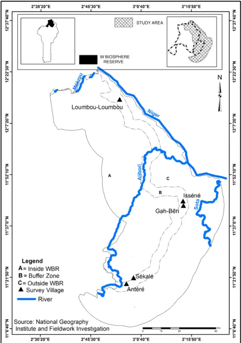
This study was carried out in the region of the WBR, in northern Benin (Figure 1). The WBR comprises about 56% of the W Transboundary Biosphere Reserve located in the countries of Benin, Niger and Burkina Faso, and covers about 5 632 km2. The WBR is located at 11º 26’ to 12º 26’ N and 2º17’ to 3º 05’ E. The natural vegetation consists of tree, shrub and woodland savannah, gallery forest and wetland. This vegetation allows the presence of wildlife valuable for conservation purposes, such as elephants, lions, buffaloes, cheetahs, waterbucks, monkeys, and various birds. The regional water supply comes from the Niger River and its tributaries: the Alibori, Mekrou, and Sota watercourses. The overall area is characterised by two main seasons: a rainy season from mid-May to October, with an average minimum daily temperature of 12 ºC, an average maximum daily temperature of 25 ºC, and precipitation ranging from 700 to 1 000 mm; and a dry season from November to mid-May, with an average minimum daily temperature of 30 ºC, an average maximum daily temperature of 40 ºC and hardly any precipitation (Billand et al., 2005). During the first part of the dry season, from November to February, a dry dusty wind blows through the North of Benin, also referred to as harmattan, which boosts the drying process of natural pastures. The harmattan facilitates burning of dried pasture, either from controlled or uncontrolled bush fire.
In Benin, the WBR is bordered by five districts, with a total of 759 300 inhabitants (INSAE, 2013). In these districts, the main economic activities are crop farming and livestock production. The WBR and its surrounding land are located in the so-called agro-pastoral contact zone in West Africa (De Haan et al., 1990), implying that land is suitable for crop farming and livestock farming, potentially enabling competition for land. Crop farmers get their main income from production of cereals (maize, sorghum, millet, rice), roots and tubers (yam, cassava, potato and sweet potato), legumes (groundnut, beans, soybean and bambara bean), vegetables (tomato, pepper, okra, pumpkin) and cotton, and possess oxen for ploughing. They belong to the following ethnic groups: Baatonu, Dendi, Monkole and Goumantche. In contrast, pastoralists obtain their main income from livestock and livestock products, and belong to the Fulbe ethnic group. The Fulbe pastoralists are dwellers of the districts
Chapter 2
20
Figure 1. The W Biosphere Reserve (WBR) in Benin (small inset map left top corner), the study area relative to the Beninese section of the WBR (small inset map right top corner) and the study area. Villages Sékalé (crop farmers) and Antéré (pastoralists) are in the southern agro-ecological zone, villages Isséné (crop farmers) and Gah-Béri (pastoralists) are in the mid agro-ecological zone and village Loumbou-Loumbou (crop farmers and pastoralists) is in the northern agro-ecological zone
Pastoralists in a changing environment
21 surrounding the WBR and some of them come from the bordering countries Burkina Faso, Niger and Nigeria, during the dry season (Tamou, 2002).
To prevent illegal activities in the WBR, such as clearing for cropping, grazing by livestock, poaching and fishing, rangers are hired and trained for patrolling inside the WBR. To engage the surrounding people in the co-management of the WBR, the
Association Villageoise de Gestion des Réserves de Faune (AVIGREF; in English,
Village Association of Wildlife Management) have been set in the bordering villages. Members of the AVIGREF are often former poachers and current crop farmers now engaged in the co-management of the WBR, by for example informing the authorities on illegal activities. AVIGREF members receive game meat and subsidies after each season of hunting and tourism.
2.2.2 Data collection and analysis
To fulfil our objectives, data were collected via Geographic Information Systems (GIS) tools, from regional statistics and through surveys.
2.2.2.1 Data collected via GIS
To analyse changes in land use in and around the WBR, via GIS tools, we defined three relevant land segments based on DeFries et al. (2005) and Clerici et al. (2007) (Figure 1):
- inWBR: the land segment inside the WBR, on the west side of the WBR
boundary with a width of 20 km;
- buffer zone: the land segment of 5 km width set by WBR authorities located
outside the WBR, on the eastside of the WBR boundary; people are allowed to use this land segment under certain conditions, such as payment of fees for crop farming, grazing, or harvesting of non-timber forest products (NTFP). One has to strictly use the sub-zone for what it has been allowed for, i.e. crop farming, grazing or NTFP harvesting;
- outWBR: the land segment of 20 km width located in the surrounding lands
outside WBR, east of the buffer zone.
We used the satellite images Landsat-8/LDCM (Landsat Data Continuity Mission) from 2014 and we identified four relevant classes using the standard supervised maximum likelihood technique (Richards, 2013):
Chapter 2
22
- Cropland: cultivated land with food crops (cereals, roots and tubers, and vegetables) and cash crops;
- Forest: land with closed forest canopy cover, either along rivers (gallery forest) or elsewhere (woodland);
- Savannah: land dominated by grass or herbaceous plants, often associated with sparse shrubs; and
- Wetland: land comprising water bodies such as rivers, ponds and streams, as well as lands along such water bodies.
The Kappa value for the land cover and land use classification was 0.96 for 2014, meaning a substantial to almost perfect agreement in the classification of the land use patterns (Viera and Garrett, 2005) .
Land use data obtained through GIS tools were analysed by comparing the area of each land use classes across the land segments.
2.2.2.2 Secondary data collected from regional statistics
To describe the dynamics of the cultivated lands, the livestock numbers and the human population, we selected three of the five administrative districts (Karimama, Malanville, Kandi) bordering the north, the east and the south part of the WBR. We collected data of land use, and human and livestock population size from regional statistics, which we refer to as secondary data. Data about cultivated land for food crops and cash crops (cotton) were derived from the database of the Centre d’Action
Régionale pour le Développement Rural (CARDER, in English Agricultural extension
services) of the province of Alibori in which the study was located. Livestock data were cattle numbers of the resident pastoralists (no distinction between the ages of the animals) and were derived from the reports of the vaccination campaigns by the Regional Office of Livestock in the province of Alibori. We did not collect data of transhumant pastoralists and their herds.
To assess the population density on cultivated land (person/ha) from regional statistics and human population, we have considered the census data of 1992, 2002 and 2013 and the cultivated land of 1997 to 2013. Since we did not have data for 1997, we estimated the human population of that year according to the formula:
Pastoralists in a changing environment
23 where is the population to be estimated at the time t in year, is the population of the previous census year, is the geometric growth rate of the population between census years, which was 3.3 % between 1992 and 2002 (INSAE 2013), and z is the number of years between the previous census year and the year t of estimation.
2.2.2.3 Data collected through surveys
To analyse the competing claims for land by the stakeholders, information was collected through community meetings and individual interviews with land users in the selected villages. Survey data collection was carried out in November to December 2014 and in April 2015. It started with a desk study and informal (without interview guide) interviews with officials from the WBR, the office of livestock management and the agricultural extension services, dealing with land use issues. We conducted an exploratory study in 15 villages in outWBR and the buffer zone. Out of these villages, we selected one in each district, being representative with regard to ethnicity, climatic conditions and cropping system. In each of the selected villages we performed community meetings and we held individual interviews with crop farmers, pastoralists, AVIGREF members and rangers (Table 1).
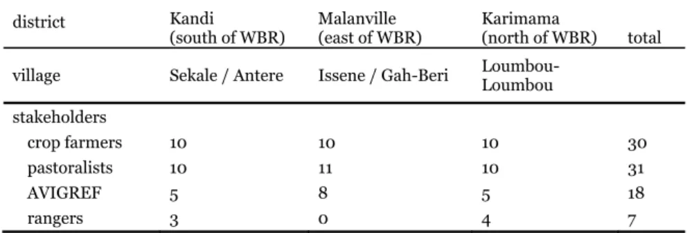
Table 1. Number of interviewees per stakeholder group and per village district Kandi
(south of WBR) Malanville (east of WBR) Karimama (north of WBR) total village Sekale / Antere Issene / Gah-Beri Loumbou-Loumbou
stakeholders crop farmers 10 10 10 30 pastoralists 10 11 10 31 AVIGREF 5 8 5 18 rangers 3 0 4 7
We held six community meetings separately with crop farmers and with pastoralists. Participants of the community meetings were elders and member of the village council. Community meetings were facilitated by the researcher using a discussion guide containing questions in French that were translated into the local language by a trained interpreter. The questions in the discussion guide covered the following items: access to land, competing claims, conflicts and their causes, relationships between crop farmers and pastoralists, the use of the buffer zone and the history of the settlement of villages. Community meetings lasted from 1.5 hour to 2 hours.
Chapter 2
24
We conducted individual interviews with crop farmers, pastoralists, members of the AVIGREF and rangers using semi-structured questionnaires with two sections. The first section was about the socio-economic characteristics, such as household size, farm type and land size, and livestock species and herd size. Using the four-point scale zero, small, medium or large, the second section of the questionnaire addressed quantity of change in land use during the last two decades (1994-2014), i.e. agricultural land availability in the outWBR. Next to that, using the four-point scale
increased, decreased, no change or don’t know, we then addressed the change of
cropland area, area of grazing land and area of watering points (natural or manmade ponds used for livestock watering). Finally, we addressed the main possible causes for changes in cropland area, grazing land area and watering points through an open question. Participants of the individual interviews were those willing to share their views on the land use issues. Individual interviews lasted between 45 minutes and one hour. The researcher asked the questions in French and the questions were then translated into the local language by a trained interpreter.
Community meeting data were analysed by coding, summarizing and categorizing respondents’ opinion in order to find patterns. Information gained from the individual surveys was analysed using descriptive statistics and analysis of variance. Stakeholders’ perception of change in land use and their related drivers were analysed with frequency and corresponding percentage, whereas means of socioeconomic characteristics were tested for difference. Where appropriate, the post-hoc Tukey test was used for significant difference between means. All statistical analyses were done using the statistical software R 3.2.2.
2.3 Results
2.3.1 Land useIn 2014, savannah and forest covered about 90% of the land in inWBR and only 9% of the land was used for crop production (Table 2). In contrast, about two thirds of the land were used for crop production in the buffer zone (i.e. 66%) and outWBR (i.e. 64%), and only 25% of the land in the buffer zone and 30% of the land in outWBR was covered with savannah and forest. Since livestock only graze in the savannah and forest, feed resources for livestock are relatively limited in the buffer zone and in the
Pastoralists in a changing environment
25 Table 2. Land use (in ha and %) per land segment in 2014
land segment
inWBR buffer zone outWBR
land use ha % ha % ha %
cropland 27 811 9 60 891 66 182 370 64
savannah 215 942 73 20 604 22 67 107 24
forest 50 007 17 2 482 3 17 679 6
wetlands 3 678 1 8 266 9 1629 6
2.3.1 Results of secondary data 2.3.2.1 Cultivated lands
Figure 2 shows cultivated land used for production of food and cash crops between 1997 and 2013. In this period, the total amount of the cultivated land used for production of food and cash crops nearly doubled from 92 000 ha to 185 000 ha, where more land is used for food crop than for cash crop production.
Figure 2. Development of cultivated land area and cattle numbers of resident pastoralists and of crop farmers
2.3.2.2 Cattle population
We distinguished two types of cattle farming in the study area: cattle farming by local pastoralists, and oxen kept by crop farmers. In Figure 2, local livestock is the sum of the number of cattle of resident pastoralists and the number of oxen (around 10% of the total) kept by crop farmers. Overall, the number of cattle decreased by more than half between 1997 and 2013. Information collected during surveys seems to indicate
0 0.2 0.4 0.6 0.8 1 1.2 1.4 1.6 1.8 2 1997 1999 2001 2003 2005 2007 2009 2011 2013 cultivated land area (10
5ha) and cattle
(10 5 num ber) of resident pastoralists Year Food crop Cash crop Total crop Cattle
Chapter 2
26
that many herds of cattle left the region, because of the difficulty to feed livestock with natural pasture.
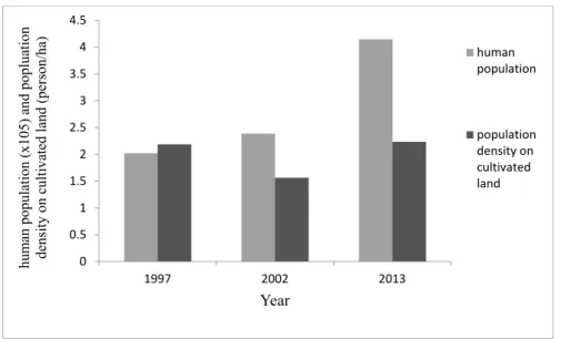
2.3.2.3 Human population and population density on cultivated land The human population more than doubled, from about 202 000 in 1997 to 414 000 in 2013 (fig 3.). The population density on cultivated land remained relatively stable between the considered periods and was 1.5 to 2.2 people ha-1.
Figure 3. Development of human population and population density on cultivated land
2.3.3 Results from surveys
2.3.3.1 Socioeconomic characteristics of stakeholders
Crop farmers, pastoralists and AVIGREF members were all involved in crop and livestock farming (Table 3). The area of crop land was larger for crop farmers and AVIGREF members than for pastoralists, whereas the number of cattle was higher for pastoralists than for crop farmers and AVIGREF members. The number of goats was lowest for crop farmers, while the number of sheep did not differ between stakeholders. These results indicate that there are no strict crop farmers or livestock farmers in the study area. All the land users practised mixed farming, where cropping was the most important activity for crop farmers and AVIGREF members, and livestock farming was the most important activity for pastoralists.
0 0.5 1 1.5 2 2.5 3 3.5 4 4.5 1997 2002 2013 hum an population (x105) and popluation density on
cultivated land (person/ha)
Year human population population density on cultivated land
Pastoralists in a changing environment
27 Table 3. Means (and standards deviation) of socioeconomic characteristics of the stakeholders stakeholders P-value socioeconomic characteristics pastoralists n =31 crop farmers n =30 AVIGREF members n =18
food crop area (ha) 3.3(1.85)b 8.2(6.18)a 8.1(4.85)a <0.001
cash crop area(ha) 0.8(1.03)b 6.6(7.00)a 5.4 (4.79)a <0.001
number of cattle 41(24.7)a 5(3.2)b 6(6.9)b <0.001
number of goats 18(20.4)a 4(4.2)b 8(16.3)a 0.003
number of sheep 9(10.2) 4(3.5) 9(14.4) 0.7
household size (no.) 11(3.6) 12(8.5) 13(4.8) 0.5
Mean values in the same socioeconomic characteristic with different letters are different (P <0.05)
2.3.3.2 People’s perception of the drivers leading to an expansion of cropland and a reduction in pastureland and watering points
In outWBR, 78 out of 86 respondents argued that no new agricultural land was
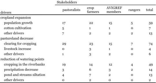
available, 6 respondents stated that new agricultural land availability was small, and 2 respondents stated that new agricultural land availability was medium. Moreover, 79 out of these 86 respondents indicated that cropland expanded over the past 20 years. Population growth was seen as the major cause for this expansion, followed by increased incentives for cotton cultivation (Table 4). Additional factors perceived to drive expansion of crop land were a decline in soil fertility and the shifting from production of food crops for subsistence to a more market-oriented production. Eighty-four out of the 86 respondents perceived that the grazing area had declined over the past 20 years. Clearing of pasture land for crop farming was perceived as the main cause of this decline in grazing area, while some crop farmers also mentioned the increase in number of livestock (Table 4). Additional factors perceived to drive this decline in grazing area were herbicide use, cotton cultivation, availability of tractors for ploughing, and cropping in the riverbanks. Indeed, herbicide use facilitates the cleaning of weeds on fields, and boosts the expansion of crop land. Cotton cultivation is subsidised by the government and its expansion is supported for the economic growth of the country. In the dry season, riverbanks of Niger are increasingly used for production of vegetables and rice, creating competition with livestock who grazed these areas previously. Tractors facilitate the ploughing of farm fields, and, as such stimulate cultivation of additional cropland; their use, moreover, is supported by the government.
Chapter 2
28
A reduction in size of watering points for livestock was perceived by 78 out of 86 respondents. This reduction was perceived to mainly result from the increase in crop farming in riverbanks, and near ponds and streams (Table 4). A decrease in precipitation and siltation of ponds and streams were perceived as additional explanatory factors.
Table 4. Frequency of drivers mentioned by the stakeholders for cropland expansion, pastureland decrease and the reduction of watering points
Stakeholders
drivers pastoralists
crop
farmers AVIGREF members rangers total cropland expansion
population growth 17 22 15 5 59
cotton cultivation 5 1 1 0 7
other drivers 7 2 2 2 13
pastureland decrease
clearing for cropping 29 23 15 7 74
livestock increase 0 3 1 0 4
other drivers 1 3 2 0 6
reduction of watering points
cropping in the riverbanks 19 14 12 4 49
precipitation decrease 3 6 3 2 14
pond and streams siltation 4 7 2 0 13
other drivers 0 2 0 0 2
2.3.3.3 The competing claims for land among stakeholders
Several competing claims for land were identified among the stakeholders. Narratives of the competing claims for lands in the three land segments (inWBR, buffer zone
and outWBR) are summarized in Table 5. The most recurrent arguments to claim
land were i) ownership due to expropriation in the past, ii) the unfair and/or incomplete implementation of the regulations in the WBR and the buffer zone, and iii) the shifting of pastoralist’s mobile lifestyle.
Pastoralists in a changing environment
29 Ownership of land due to past expropriation
The competing claims related to land expropriation in the past are between crop farmers and the WBR authorities and between crop farmers themselves. There were people settled in the current core of the WBR before its establishment as a National Park in 1954. Later, those people were displaced from inside the WBR, either by military force or with the purpose to shift state administration from dispersed homesteads into compact settlements close to main roads. This caused the resettlement of people in the current border of the WBR. Hence, nowadays, people claim ownership of land in the inWBR segment due to expropriation of ancestors’ lands. In addition, some competing claims appear between the crop farmers who were already living in outWBR and the crop farmers that were resettled.
Unfair and incomplete implementation of WBR’s regulations
The incomplete implementation of the regulations in the WBR and in the buffer zone is the argument of claims for land among crop farmers; between crop farmers and pastoralists; and between farmers and the authorities of the WBR.
In the study area, crop farmers living far away from the border of the WBR have been cultivating inside the WBR for relatively few years. Crop farmers living close to the WBR informed the WBR authorities to get them out, but no prosecution, enforcement or sanctions were taken. This was frustrating for the crop farmers living close to the WBR, even more so, because the land in the WBR once belonged to their ancestors and they feel that if someone has rights to these lands it should be them. In addition, in the South West part of the WBR (which is not part of the study area, but adjacent to it), thousands of hectares of lands are cultivated inside the Park (Houessou et al., 2013) with no reaction from Park officers. This situation, known to the inhabitants in the study area, has raised complaints and frustrations among the crop farmers and pastoralists. Now, they request land for cropping and grazing inside the WBR, as happens in this South West part.
The buffer zone was initially set to hold a cropping sub-zone, a grazing sub-zone, and a NTFP sub-zone (in consecutive parallel land segments from outWBR to inWBR) to be used by crop farmers, pastoralists and all inhabitants respectively. Each sub-zone was to be delimited to avoid encroaching use among these users. However, until now, these sub-zones have not been demarcated. As a consequence, cropland expanded
Table 5. Nar ratives of competin g clai ms for land among st akeholders (in bold) in each
land segment (into
brackets)
Clos
e-border crop farm
ers ve rsu s far-bor d er crop far m er s ( inWBR) Clos e-border farm ers : "We are c los e to the WBR but we are not cro p pi ng in sid e the WB R and pe ople far aw ay fro m the bord er of the WBR
come to do so. They had
no right t o do s o." Far-border crop far m er s : " O n ly the Gover n ment owns the W BR and ther efore, it is
only the gover
n
ment that allows som
eone to cultiv at e ins ide th e W BR and we a re als o res ide nts of t he per iph era l zo ne of the WBR. " Crop farm ers versus cr op f a rm ers ( outWBR ) Crop farm er A :
"This area is where
o ur pare nts ha ve b een cu lti vati n g si nc e w e w ere y oun g . B u
t the head of this fam
ily B is now claim ing the are a beca use it belo n g s to his gr a n dp ar ent " Crop farm er B : "Whe n t he p a re nts of fam ily A arr ived in t his v illa ge fro m a ne ighb ouring village th ey requested a land t o cu ltivate and t his la nd
was not giv
en bu t bo rr owed, now we want it ba cks" Pa stora lists versus crop farmer s (buffer zone) Pa stora lists : "We cl ai me d this are a th at cro p far m ers were c le a ri ng because it is devoted t o graz ing, accord ing to th e rules relating t o the use of the buff er z one. They we re doi n g so b ecau se th e ar ea soil h a s been enr ich ed by
the manure of our catt
le ." Crop farm ers : " P as tor a li sts wi ll cl ear the ar ea for cro p ping o n e day. They a re al so cult iv a ting i n th e bu ffer z one, so we shou ld als o cr op in the gr azi n g a rea of th e buf fer zo ne . Mor eov er, th
ey are not autoch
thones of th is area, so th ey h a d n o r ig ht t o c la im a n y l a n d i n t hi s a re a a n d nobody know s the border between cr op pi ng z on e a n d graz in g zo n e. " Pa stora lists versus crop farmer s (ou tWBR) Pa stora lists : "Nowad ays,
even hills and some stony land ha
ve been cultivated, so we ha ve to go far aw ay from crop fi eld s in the ra iny sea so n until the harv est tim e ." Crop farm ers : "Th e la nd where past or al ists cr op a n d gr aze w a s hand ed dow n to us by ou r grand-parents. Past oralists are livestock keepers not crop far m ers. P a st or alists sh ould stick t o keeping liv estock ." Pa stora lists versus crop farmer s
(wetlands and riverb
anks, outWBR ) Pa stora lists : "N ow a d a ys, wa te rin g po in ts d ry up f a st bec a us e cr op fa rm er s plou gh close to th e ponds or in the lowlands and riverb anks . They hav e ac cel erat ed th e silt ati on of th ese wat eri ng po int s. Mor eover, w e cou ld not us e thi s are a for graz ing i n the dry seas on ." Crop farm ers replied: "Soi ls ar e not ferti le a n ym ore, only t he low la n ds and t he ri ve rbanks are f erti le. W e want t o fe ed pe ople but past or al ists want t o fe ed anim als. I n my op inio n, it is better t o do the f orm er than t he latt er "
Pa stora lists and cro p fa rmer s versu s W BR offic e rs (i nWBR ) Crop farm ers : i) “
Our village has been resettled
by the ranger s in this curren t l ocatio n bu t t h e tom bs of o u r ancest
ors are still o
ver t h ere, in the WBR"; ii ) "W BR offi cers a re not f a ir b ecau se th ey all ow peo p le to cr op or g raze i n s om e are a s of t he WBR but no t in othe rs, l ike ours fo r inst ance" . Pa stora lists : i) "Why do ran g er s ki ll our an im als to prot ect ot her an im als, as th ey kn ow that we d on' t ha ve any g razi n g ar ea? " ii ) " WBR officers ar e c ons erv
ing wild anim
als for fu ture generation. Wh en was t his Park create d ? Our gr and-parents w ere graz ing in th is so-ca lle d Park m a ny years ag o with out bei n g bot hered by a n yon e" WBR office r : "Cro pl a n d is e n cr oac hi n g i n to th e Re serve an d p a stora lis ts ar e graz in g i n t he m a ny l a n d s ins ide t he Reserv e. The most th re at to th e res erv e is cro p f a rm in g. We k n ow th at past ora lists ar e f orce d to gr az e i n sid e bec a use th ere is n o gr azi n g l a n d outs ide. However, thes e act ivit
ies are ill
eg a l, an d we hav e to g et them al l out"
Chapter 2
32
into the grazing sub-zone (trend also seen in Table 2), and conflicts caused by the competing land claims arose between crop farmers and pastoralists.
The shifting of pastoralist’s mobile lifestyle
Historically, Fulbe pastoralists have been related to a mobile lifestyle searching for grazing resources for their herds. However, in response to land scarcity for grazing, they have turned to a sedentary lifestyle and started cropping on lands where their livestock were grazing previously. Crop farmers reacted by saying that pastoralists are allochthones and crop farmers are autochthones. Being autochthone involves a spiritual bond with the land, hence landownership and supremacy over the allochthones who were then denied to own land. Thus, the shifting of pastoralists’ mobile lifestyle led to the competing claims for land between pastoralists and crop farmers.