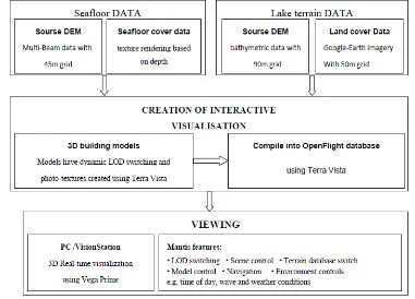
To Go Where we Have Never Been to: 3D Real Time Visualizatuion of Terrain Database
Full text
Figure

Related documents
The house, built in 1911, is an early Vancouver home, valued for its association with the growth and development of the Cedar Cottage neighbourhood, once part of the
Subsequent to recognition of impairment, effective income is measured at the rate used to measure the impairment, i.e. the current market IRR underlying the fair value.
Respondents who feel ease of telecommunication or signal have stated strongly agree as many as 7 respondents with percentage of 17.5 percent, agree 23 respondents with
Al vanaf de eerste keer dat de schilderijen te zien zijn in de films wordt duidelijk dat de bewegingen in schilderijen niet slechts een korte lus zijn zoals het geval bij de
For the topologies studied, this suggests that in an idealized fractional bandwidth routed network the increase in network throughput achieved by improving the transceiver coding can
While impractical, it was also clear that the culture of the organization would not allow for the introduction of such sheets. Solutions discussed about
The wisdom that lies behind this quote started a project for finding best integrated Busi- ness Intelligence (BI) solutions in the market. Progress of this project is documented in
Floyd, from DAU’s Logistics and Sustainment Center, served as a member of a panel on “Life-Cycle Sustainment Options and Incentivizing Contractor Investment” in which he
