ISSN Print: 2327-4336
DOI: 10.4236/gep.2019.79005 Sep. 19, 2019 58 Journal of Geoscience and Environment Protection
Mapping of Stream Flow Trends in Porsuk
Basin Using GIS Environment
Yıldırım Bayazıt
1, Recep Bakış
2, Cengiz Koç
31Department of Civil Engineering, Bilecik Şeyh Edebali University, Bilecik, Turkey
2Department of Civil Engineering, Anadolu University, Eskişehir, Turkey
3Department of City Regional Planning, Muğla Sitki Koçman University, Muğla, Turkey
Abstract
In this study, trends of minimum, average and maximum flows were investi-gated in Porsuk basin, which is a sub-basin of Sakarya basin and then changes in flows were mapped using Geographical Information Systems (GIS). In the study, in 10 flow gauging stations across the Porsuk basin, monthly average, maximum and minimum flow data is used covering the period 1961-2013 (53 years). When analyzing the distribution of observed trends in the basin, a trend has been observed in most of the river flows. A decreasing trend has been observed overall in the basin. Trends are generally decreasing over time except for a few stations. As a result, increasing trends are observed in the west part of the basin; while in the east part of the basin decreasing trends are observed. When average and maximum monthly flows are investigated, de-creasing trends are observed in the stations except DSI-12182. Trend analysis of 10 flow gauging stations across the Porsuk basin is investigated by Mann-Kendall method. Trend distribution was made according to flow trends of basin by transferring Z values to GIS.
Keywords
Flow Gauging Station (FGS), Porsuk Basin, Mann-Kendall, Trend Analysis, Geographical Information Systems (GIS)
1. Introduction
Since the formation of the atmosphere, global climate systems have tended to change temporally and spatially within their natural variability. This tendency of variability was directly related to the natural changes of various components in the Sun, atmosphere or in the earth/atmosphere combined system until the How to cite this paper: Bayazıt, Y., Bakış,
R., & Koç, C. (2019). Mapping of Stream Flow Trends in Porsuk Basin Using GIS Environment. Journal of Geoscience and Environment Protection, 7, 58-66.
https://doi.org/10.4236/gep.2019.79005
Received: July 30, 2019 Accepted: September 16, 2019 Published: September 19, 2019
Copyright © 2019 by author(s) and Scientific Research Publishing Inc. This work is licensed under the Creative Commons Attribution International License (CC BY 4.0).
http://creativecommons.org/licenses/by/4.0/
DOI: 10.4236/gep.2019.79005 59 Journal of Geoscience and Environment Protection middle of the 19th century. However, for the first time, human activities have also been added to the natural change components in global climate systems and they have started to become quite effective as well (Yıldız & Malkoç, 2000).
The global warming caused by the greenhouse effect, which started at the end of the 19th century, was strengthened by the greenhouse gases that continue to accumulate in the atmosphere. Then it became more evident especially after the 1980s and it has reached its highest values in the 1990s. Within the global di-mension of the effects of climate change due to global warming, regional and temporal differences may occur, as in previous climate changes. This means that in the future, especially in some parts of the world, there will be an increase in the intensity and frequency of hurricanes, as well as in strong rains and meteo-rological disasters such as floods and overflows; while long-term, severe drough-ts and associated widespread desertification evendrough-ts may be more effective in some regions of the world. Precipitation has shown an increase in land areas in the high latitudes of the Northern Hemisphere in general, especially in the cold season, but it has shown a decreasing tendency on the subtropical and tropical zones extending from Africa to Indonesia after the 1960s. These changes have been observed as well in rivers, lake levels and soil moisture (Yıldız & Malkoç, 2000).
Nowadays, the increase in the population and the increasing industrial facili-ties cause the water demand to increase continuously. In order to meet the in-creasing water demand, measures such as transporting the water from the ab-undant places to lesser places and creating water storage tanks can be imple-mented. However, the most effective way to deal with water demand is to study the past behavior of water and then predict its future behavior based upon that. Knowing the time series of water quantities helps to use and plan the existing storage of water as well as the future storage of water more carefully. People, in-stitutions and organizations that are investing in hydrology, hydrometeorology and water, have to know how the future stream flows in the basin will be changed. The past data of river flows which are based on year, season, month or day is required for future planning (Cığızoğlu et al., 2002).
DOI: 10.4236/gep.2019.79005 60 Journal of Geoscience and Environment Protection A reduction in annual average flows carries importance for determining the storage capacity as well as the realization of storage operations. An increase in maximums is important for the design of the dam-filled sluice. The river flow data used in the study were obtained from the 3rd Regional Directorate of State Hydraulic Works (1961-2013), and the final data was determined by using the Mann-Kendall test, which was used to determine whether the results of the flow data could be considered as significant trends. Statistically significant trends were evaluated at basin scale in a GIS environment and trend distribution maps were created as a result.
2. S
tudy Area and Method
2.1. Study Area
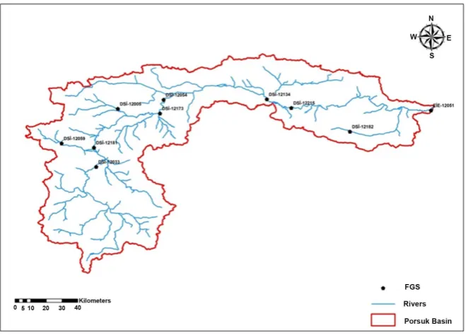
Porsuk Basin, a sub-basin of Sakarya Basin no. 12 was chosen as the test region. The data obtained from the FGSs operated by the State Hydraulic Works on the selected rivers in the Porsuk basin were used. Current flow gauging stations con-sidered in the study are given in Table 1, Figure 1.
Long-term monthly average flow values, which are dependent on many years of measurements that were measured in flow gauging stations (some of which are specified in Table 1), have been completed by regression analysis and then the missing flow values seen in Figure 2 have been adjoined to create complete and unified data. For the purpose of trend analysis of these data, minimum av-erage and maximum avav-erage flow values were extracted for each measured year of each station.
2.2. Method
2.2.1. Mann-Kendall Tendency Test
[image:3.595.63.537.545.703.2]Mann-Kendall test (Yu et al., 1993)is a special application of the test known as Kendall’s Tau and it is a non-parametric test. Mann-Kendall tendency test is a non-parametric test and it is not affected by the distribution of variables (Önöz et al., 2007). This method, which is most commonly used in the analysis of
DOI: 10.4236/gep.2019.79005 61 Journal of Geoscience and Environment Protection
Figure 2. Measurement years of flow data.
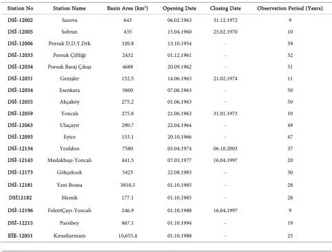
Table 1. FGS utilized for Porsuk Basin data.
Station No Station Name Basin Area (km2) Opening Date Closing Date Observation Period (Years)
DSİ-12002 Sazova 643 06.02.1963 31.12.1972 9
DSİ-12005 Sobran 435 15.04.1960 25.02.1970 10
DSİ-12006 Porsuk D.D.Y.Drk 320.8 13.10.1954 - 59
DSİ-12033 Porsuk Çiftliği 2432 01.12.1961 - 52
DSİ-12034 Porsuk Baraj Çıkışı 4688 20.09.1962 - 51 DSİ-12051 Genişler 152.5 14.06.1963 21.02.1974 11
DSİ-12054 Esenkara 5600 07.06.1963 - 50
DSİ-12055 Akçaköy 275.2 01.06.1963 - 50
DSİ-12059 Yoncalı 275.8 21.06.1963 31.01.1973 10
DSİ-12063 Uluçayır 290.7 22.04.1964 - 49
DSİ-12093 Eyice 153.1 20.10.1966 - 47
DSİ-12134 Yesildon 7580 03.04.1974 06.10.2003 37 DSİ-12143 Maslakbaşı-Yoncalı 441.5 07.03.1977 16.04.1997 20
DSİ-12173 Gökçekısık 5425 22.08.1983 - 30
DSİ-12181 Yeni Bosna 3810.5 01.10.1985 - 28
DSİ12182 Memik 177.1 01.10.1985 - 28
DSİ-12196 FelentÇayı-Yoncalı 246.9 01.10.1988 16.04.1997 9
DSİ-12215 Parsibey 867.1 01.10.1994 - 19
[image:4.595.55.538.372.739.2]DOI: 10.4236/gep.2019.79005 62 Journal of Geoscience and Environment Protection hydro-climatological data, is an excellent method for finding trends, and it is based on the order of the data rather than the size of the data (Partal, 2003). Mann-Kendall rank correlation is a method independent of distribution to find the relationship between the two variables (Kosif, 1999). The Mann-Kendall test is particularly suitable for normally distributed data with extreme and non-linear tendencies (Helsel & Hirsch, 1992; Birsan et al., 2005). This technique is very useful for data that does not need to comply with low and normal distribu-tion (Yu et al., 1993). In this test, time-based observations show that the time-independent and similar distributed random variables according to the H0 hypothesis and that the H1 hypothesis shows that the values of these distribu-tions are not similar, i.e. there is no linear trend in the sequence. Thus, the said test to be applied in this research is given in Equality (1).
(
)
1
1 1sgn
n n
j k
k j k
S − x x
= = +
=
∑ ∑
− (1)In the equation, xj and xkshow the flow rates in years j and k, respectively. If
j > k, then the sign function is written as in Equation (2).
(
)
(
(
)
)
(
)
0 1
sgn 0 0
1 0
j k
j k j k
j k
x x
x x x x
x x
+ − >
= − = − = − − < (2)
The theoretical distribution of S statistics is normal in long data. Accordingly, the mean and variance were calculated by Equation (3).
0 s µ = ve
( )
(
)(
)
( )(
)(
)
11 2 5 m i 1 2 5 18
i
Var S n n n t i i i
=
= − + − − +
∑
(3)Standard normal variable was calculated by Equation (4).
( )
( )
1 0 0 0 1 0 S S Var S Z S S S Var S − >
= =
+
<
(4)
Compared with the standard normal variable significance level (α: 0.05), if |z| < zα/2, then the H0 hypothesis is accepted, and if it is not, then the hypothesis is rejected. If the calculated Z value is positive, it is stated that there is an increas-ing tendency and if it is negative, it has a decreasincreas-ing tendency. The calculated Z value ranges from (−1.96) to (+1.96) when there is no trend. If Z value is greater than (+1.96), it shows that there is a statistically increasing tendency and if it is less than (−1.96) then it shows a decreasing trend (Aksoy, 2002).
2.2.2. Inverse Distance Weighted-IDW Method
trans-DOI: 10.4236/gep.2019.79005 63 Journal of Geoscience and Environment Protection ferred to GIS environment by applying IDW method and trend distribution maps were created on Porsuk basin. Figure 3 shows the selected FGSs for trend analysis in Porsuk basin.
Weighting by inverse distance is an estimation method that assigns a higher weight value to nearby points than distant points and which also takes into ac-count all possible sample points. Each sample point has an inverse weight value based on its distance from the point to be estimated. The estimated value at point x0 is calculated as shown in Equation (3).
( )
( )
1
1
1 p
i i
i n
p i
i i
d x W
d x
= =
∑
(5)( )
0 i( )
iZ x∗ =
∑
W Z x⋅ (6)Here; Z x∗
( )
0 means the value of the prediction at point x0, Z(xi): the value of the sample point at point xi, Wi: the weight of the inverse distance relative to the point x0 of the sample, d: the distance between the sample point and the point to be estimated,p: the exponential value, n: the number of sample points.
3. R
esearch F
indings
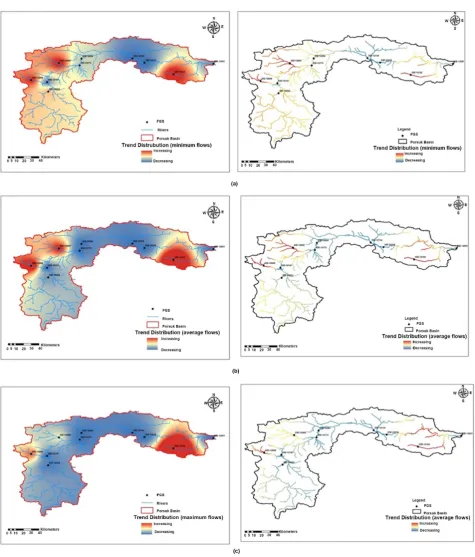
[image:6.595.209.539.472.709.2]In this study, long term monthly current data of 19 current monitoring stations were examined and trends of mean, minimum and maximum current data were examined. Of the examined stations, 9 stations did not show a specific trend, whereas 10 stations showed a trend. The trends of these stations were analyzed by spatial estimation in GIS software according to IDW method. The map of the
DOI: 10.4236/gep.2019.79005 64 Journal of Geoscience and Environment Protection
Figure 4. Trend distribution maps of (a) minimum, (b) average and (c) maximum flows for Porsuk Basin.
trend distributions of the Porsuk basin average, minimum and maximum flows is given in Figure 4.
DOI: 10.4236/gep.2019.79005 65 Journal of Geoscience and Environment Protection
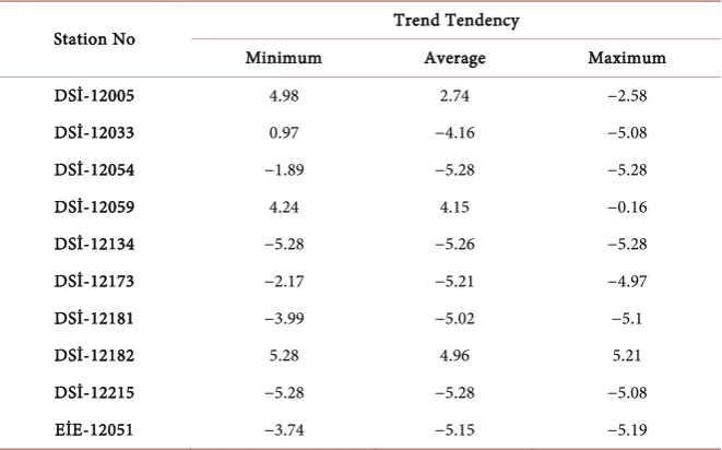
Table 2. Mann-Kendall test results.
Station No Trend Tendency
Minimum Average Maximum
DSİ-12005 4.98 2.74 −2.58
DSİ-12033 0.97 −4.16 −5.08
DSİ-12054 −1.89 −5.28 −5.28
DSİ-12059 4.24 4.15 −0.16
DSİ-12134 −5.28 −5.26 −5.28
DSİ-12173 −2.17 −5.21 −4.97
DSİ-12181 −3.99 −5.02 −5.1
DSİ-12182 5.28 4.96 5.21
DSİ-12215 −5.28 −5.28 −5.08
EİE-12051 −3.74 −5.15 −5.19
did not show any trend distribution, while 63.32% decreased and 11.69% showed increasing trends. According to maximum flows, 6.65% of the basin did not show trend distribution, while 76.77% of it decreased, and 16.58% of the basin showed increasing trend distribution. In the basin, DSİ-12182 flow gauging sta-tion showed an increasing trend in all flows. In general, it can be said that the basin is in a trend of decreasing flow.
4. Conclusion
In this study, monthly average, minimum and maximum flow data of 19 flow gauging stations of Porsuk Basin, which is one of the important sub-basins of Sakarya Basin, were determined by the application of the Mann-Kendall test. In the analyses, the data of the current observation stations covering the flow data of the years 1961-2013 in the basin were examined and 10 stations with significant trend values were found. The trends of these stations are recorded in the GIS database and distributed in the GIS environment according to the IDW method, which is a spatial estimation method. As a result of the study, trends of the flows along the basin were determined according to the mean, minimum and maxi-mum values of the flows (Table 2).
According to the results, no change in trends was observed in more than half of the basin at minimum flows. On average and maximum flows, a declining trend was observed in most of the basin. These results can be accepted as an in-dicator of future water shortages in the basin. For this reason, the water re-sources in the basin should be evaluated well and necessary precautions should be taken.
Acknowledgements
DOI: 10.4236/gep.2019.79005 66 Journal of Geoscience and Environment Protection
Conflicts of Interest
The authors declare no conflicts of interest regarding the publication of this pa-per.
References
Aksoy, B. (2002). Akdeniz Bölgesinde Yağışların Yıllıkve Mevsimlik Yağış Verilerindeki Eğilimler Ve Dalgalanmalar Üzerine Birİnceleme (p. 64). İzmir: Ege Üniversitesi Fen BilimleriEnstitüsü, Yüksek LisansTezi (Basılmamış).
Birsan, V. M., Burlando, P., & Pfaundler, M. (2005). Streamflow Trends in Switzerland. Journal of Hydrology, 314, 312-329.https://doi.org/10.1016/j.jhydrol.2005.06.008 Cığızoğlu, K., Yıldız, M., Bayazıt, M., Malkoç, Y., & Önöz, B. (2002). Türkiye Nehirleri
Taşkın Ortalama VeDüşük Akımlarındaki Trendler (p. 265). İTÜ İnşaat Fakültesi Dekanlığı—Elektrikİsleri Etütİdaresi Genel Müdürlüğü, İTÜ Araştırmafonu Projesi. Helsel, D. R., & Hirsch, R. M. (1992). Statistical Methods in Water Resources (522 p.).
Amsterdam: Elsevier.
Kosif, K. (1999). Yeşilırmak Havzasıİklim Parametrelerinin Trend Analizi (p. 115). An-kara: Gazi Üniversitesi Fen Bilimleri Enstitüsü, Yüksek Lisans Tezi (Basılmamış). Önöz, B., Yeğen, E. B., & Cebe, E. N. (2007). Türkiye Akarsularında Mevsimsel Trend
Analizi (pp. 267-277). V. Ulusal Hidroloji Kongresi, 5-7 Eylül 2007, Ankara: OrtaDoğu Teknik Üniversitesi.
Partal, T. (2003). Türkiye Yağış Verilerinin Trend Analizi. İstanbul: İstanbul Teknik Üniversitesi Fen Bilimleri Enstitüsü, Yüksek LisansTezi (Basılmamış).
Yıldız, M., & Malkoç, Y. (2000). Türkiye Akarsu Havzalarıve Hidrolojik Kuraklık Analizi (p. 241). Ankara: Elektrikİsleri Etütİdaresi Genel Müdürlüğü.
Yu, Y. S., Zou, S., & Whittemore, D. (1993). Non-Parametric Trend Analysis of Water Quality Data of Rivers in Kansas. Journal of Hydrology, 150, 61-80.