http://www.scirp.org/journal/jcc ISSN Online: 2327-5227
ISSN Print: 2327-5219
DOI: 10.4236/jcc.2019.77003 Jul. 10, 2019 17 Journal of Computer and Communications
Research on a Watermarking Algorithm for
Remote Sensing Images Resist Screen Capture
Attacks in Urban Planning Information
Management
Xiao Wang, Jiangang Xu, Yiming Yin
School of Architecture and Urban Planning, Nanjing University, Nanjing, China
Abstract
Remote Sensing data, as an essential urban basic information in urban planning, has the characteristics of large information capacity, real time, high update speed and accuracy. Because of urban spatial information in-volving multi-faceted public and public interests, its data security is very important. The use of digital watermarking technology can effectively protect the security of urban planning basic data. In practical applications, the “screen capture” poses a great threat to the security of remote sensing image. In order to resist the screen capture attacks, the QR code water-mark information is encoded and converted, and combined with a circular angle template watermark, a digital watermarking algorithm for remote sensing images in urban planning information management is proposed. And the proposed algorithm is experimentally verified. Experiments show that the algorithm is robust against screen capture attacks, and provide security guarantee for urban construction and management.
Keywords
Remote Sensing Image, Digital Watermarking Technology, Screen Capture Attack, Circular Angle Template Watermark
1. Introduction
Remote Sensing data, one of the sources of geospatial information, has the characteristics of large information capacity, real time, high update speed and accuracy. It plays an important basic and strategic position in national geo-graphic information resources [1]. As an efficient technical method, remote sensing technology provides an effective data foundation for urban planning, so that cities can be planned efficiently, rationally and scientifically, and
ur-How to cite this paper: Wang, X., Xu, J.G. and Yin, Y.M. (2019) Research on a Wa-termarking Algorithm for Remote Sensing Images Resist Screen Capture Attacks in Urban Planning Information Management. Journal of Computer and Communica-tions, 7, 17-27.
https://doi.org/10.4236/jcc.2019.77003
DOI: 10.4236/jcc.2019.77003 18 Journal of Computer and Communications ban land planning can be coordinated to realize urban ecological, healthy and sustainable development [2]. At present, remote sensing image is widely used in urban planning, mapping drawing, land use dynamic assessment and envi-ronmental monitoring. For example, obtaining multi-sequence image data at different time periods can visually describe the process of urban spatial ex-pansion and urban land use change [3]. In addition, comparing the orthopho-to map with the planning scheme can not only reflect the relationship be-tween urban status and urban planning, but also verify the rationality and operability of the planning scheme [4]. However, in the process of using re-mote sensing data, its data security issues have also become increasingly prominent. It is extremely urgent to protect the security of remote sensing images.
As a kind of information security technology, digital watermarking tech-nology uses a specific algorithm to hide the watermark information in the original data to determine the copyright owner, track the infringement be-haviors, content authentication and data source. Digital watermarking nology can effectively deter and track the leakers, it provides a feasible tech-nical method for the protection of remote sensing images.
With the development of digitalization and the popularity of smart phones, screen capture is relatively simple and common. For example, in the process of distribution of confidential remote sensing images, it is difficult to protect the data copyright information if a person who is exposed to confidential data leaks the data through a screen capture. How to protect data copyright against screen capture is a problem that needs to be solved.
There are few researches on watermarking algorithms against screen cap-ture attacks at home and abroad, and the construction of such watermarking algorithms can depend on other watermarking algorithms which can be ro-bust against print-scan and print-cam attacks. Some research results of digital watermarking algorithms against print-scan are as follows. Chen [5] pro-posed a watermarking algorithm based on polarized DCT coefficients by con-sidering the properties of DCT coefficients under print scan attack and modi-fying the polarities of DCT domain coefficients. Amiri [6] proposed a robust watermarking against print and scan attack based on DWT and DCT domains. And the appropriate location of the watermark was determined by analyzing the effects of the modeling algorithm. Xie [7] proposed a double transform domain holographic watermarking algorithm, which can effectively resist print scanning attacks. Liao [8] presented a robust blind watermarking scheme based on uniform log-polar mapping and perceptual band decompo-sition of Fourier domain.
com-DOI: 10.4236/jcc.2019.77003 19 Journal of Computer and Communications bining DFT to propose a watermarking algorithm against print-cam. Pramila [11] encoded the watermark information into a square angle tem-plate with periodicity and directionality, and completed the watermark embedding in the form of block. The watermark extraction was realized by detecting the angle feature. This algorithm can effectively resist the print photo attack.
In this paper, we encoded and converted the watermark information in combination with a circular angle template. A digital watermarking algorithm based on QR Code and circular angle template is proposed. It provides a prac-tical technical approach to the protection of basic data in urban planning.
2. Proposed Method
The proposed method encodes the watermark information into angle infor-mation, and embeds the watermark information by constructing a circular angle template watermark. The watermark embedding rule is realized by changing the JND values of the original remote sensing image. And by detect-ing the hidden angle information in the circular angle template, the corre-sponding watermark information will be obtained.
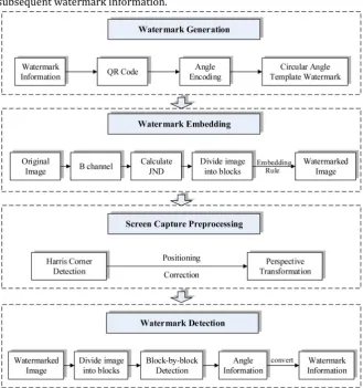
The key technologies of the proposed method mainly include: 1) Position-ing and correction of screen capture data, 2) Watermark information pre-processing, 3) Angle watermark detection. The whole procedure of the algo-rithm is depicted in Figure 1.
2.1. Watermark Generation
2.1.1. Circular Angle Template Construction
1) Generate a periodic and directional template watermark randomly Firstly, a basic template watermark block is randomly generated. Then, the basic template watermark block is repeated in the vertical direction and the horizontal direction according to Formula (2.1). Finally, a basic template wa-termark with periodicity and directivity is generated.
The formula is as follows:
1 0 0
0 1
1 1 0
, ,
1, 1
, ,
W x N y W x y
N N
W x N y W x y
(2.1)
where N0 and N1 refer to the number of repetitions in the horizontal
di-rection and the vertical didi-rection.
2) Generate a basic circular template watermark
Converting the basic square template watermark W x y1
, into the basiccircular template watermark W x y
, by finding the inscribed circlemeth-od.
3) Generate a circular angle template watermark
According to the angle information encoded by the watermark infor-mation, the basic circular template watermark W x y
, is rotated togener-ate a circular angle templgener-ate wgener-atermark with angular features W
x y, .DOI: 10.4236/jcc.2019.77003 20 Journal of Computer and Communications subsequent watermark information.
Figure 1. The proposed algorithm framework.
Compared with the square angle template watermark [11], the circular an-gle template watermark constructed in this paper has the following two ad-vantages:
a) In the aspect of changing the pixel value of the carrier image, compared with the square angle template watermark, the circular angle template is used as the watermark information to embed, and only the pixel value cov-ered by the square inscribed circle is changed. The change range of pixel val-ue is small. It makes the pixel valval-ue of the whole carrier image change less.
DOI: 10.4236/jcc.2019.77003 21 Journal of Computer and Communications 2.1.2. Watermark Generation
In order to enhance watermark robustness, the image is preprocessed. The main procedures are as follows:
1) Meaningful textual information is fetched.
2) Textual information is converted to a QR code based on the generating rules for the latter.
3) Convert the QR code into its corresponding binary sequence by the pro-gressive raster scanning method.
4) The binary sequence is encoded every four bits, and the encoded wa-termark information is converted into circular angle template wawa-termark with angle information.
2.2. Watermark Embedding
The detailed watermark embedding procedure is stated below. 1) Get the B channel pixel value
Read the remote sensing image, then get its blue channel pixel value
,B x y , M and N are the length and width of the remote sensing image.
2) Calculate JND (Just Noticeable Distortion)
Calculate the JND value of remote sensing image, the JND value is obtained by the luminance model and the texture model.
3) Divide the remote sensing into blocks
According to the number l1 of embedded template watermark blocks, the
remote sensing image is
1 2
M N
l l divided to ensure that each circular angle
template watermark W
x y, can be embedded into the remote sensingimage sub-pixel matrix block.
4) Rules for embedding watermark information
The circular angle template watermark is embedded into the remote sens-ing image to obtain the watermarked remote senssens-ing image, and the embed-ding rule is as shown in Formula (2.2).
1
1
, , 10 , ,
1 , ,
i i
B x y B x y JND x y W x y
JND x y W x y
(2.2)
where, B x yi
, is the i-th block B channel pixel value, B x yi
, is the i-thblock B channel pixel value after embedding the watermark. 1 is the
em-bedding strength, W
x y, is the circular angle template watermark.2.3. Screen Capture Preprocessing
1) Positioning
The four corner points of the data to be detected are obtained by Harris corner detection for data positioning, and redundant information such as background is removed according to the positioning point.
DOI: 10.4236/jcc.2019.77003 22 Journal of Computer and Communications By using perspective transformation to eliminate the distortion caused by factors such as shooting angle, and thus less distortion and effective data in-formation can be obtained.
2.4. Watermark Detection
The traditional detection of watermark information involves the opposite processes to watermark embedding. In the paper, the original watermark in-formation is obtained by detecting the hidden angle inin-formation in the circu-lar angle template.
The main procedures are as follows: 1) Get the B channel pixel value
Read the data to be detected after preprocessing, and obtain its B channel pixel value.
2) Block-by-block watermark information detection
First of all, the winner filter is performed to remove the noise that may be added; then, the autocorrelation function is calculated to generate a large au-tocorrelation peak point; thirdly, the gradient point is used to sharpen the peak point; what’s more, add morphological knowledge—expansion and cor-rosion to make peak points more visible; finally, the line angle is detected by Hough transform to obtain angle information.
3) Convert Angle information to watermark information
According to the angle range of detection angle, the watermark in-formation is obtained.
4) Text watermark information is decoded by QR code
The extracted sequence of watermark information is converted to a QR code. The latter is then scanned to obtain the textual information contained within.
3. Experimental Results and Analysis
DOI: 10.4236/jcc.2019.77003 23 Journal of Computer and Communications
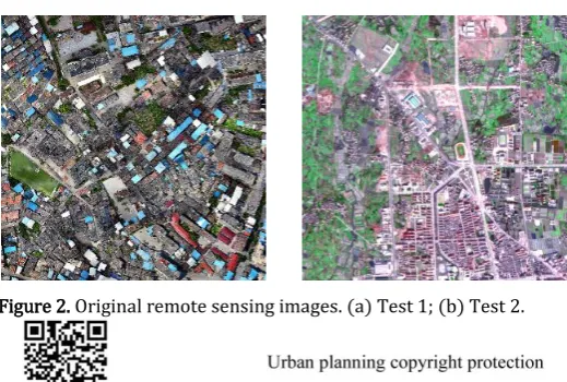
Figure 2. Original remote sensing images. (a) Test 1; (b) Test 2.
Figure 3. QR code and scan result.
In this experiment, under the premise that the experimental data and wa-termark information are known, the number of remote sensing image blocks is set to 10 × 10, and the watermark embedding intensity is set to 12. At this time, the watermark information capacity of the algorithm can be em-bedded up to 400 bits. It can meet the actual application requirements of wa-termark information capacity.
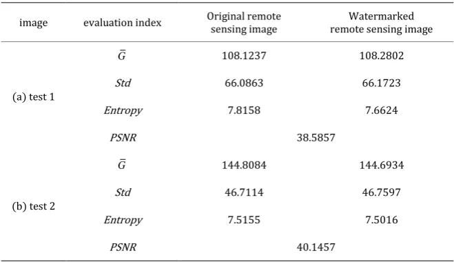
3.1. Analysis of Imperceptibility
A good digital watermarking algorithm can protect the security of re-mote sensing image data without affecting the later use of the data. Imperceptibil-ity is the criterion for verifying whether the watermarking algorithm affects the later use of the data. In order to verify the imperceptibility of the algo-rithm, this study will be illustrated from two aspects: subjective visual analy-sis and objective quantitative evaluation.
The watermarked remote sensing images and extracted QR code are shown in Figure 4 and Figure 5, respectively.
1) Subjective visual analysis
Comparing Figure 1 and Figure 3, it can be found from the subjective visual that there is no visible difference between the remote sensing images before and after embedding the watermark. The experimental analysis proves that the algorithm has good invisibility.
2) Objective quantitative evaluation
DOI: 10.4236/jcc.2019.77003 24 Journal of Computer and Communications experiential threshold value of 28. The objective evaluation indices ade-quately illustrated that there is no significant reduction in image quality after embedding of a watermark that is generated using the proposed algorithm.
3.2. Analysis of Screen Capture Attacks
There are a variety of screen capture devices. In this paper, mobile phones were used for screen capture, and desktop computer monitors were used for electronic screen equipment. The parameter settings for screen capture are shown in Table 2.
Figure 4. Watermarked remote sensing images. (a) Water-marked test 1; (b) WaterWater-marked test 2.
[image:8.595.259.483.205.311.2]Figure 5. Extracted QR code and scan result.
Table 1. Objective quantitative evaluation.
image evaluation index Original remote sensing image remote sensing image Watermarked
(a) test 1
G 108.1237 108.2802
Std 66.0863 66.1723
Entropy 7.8158 7.6624
PSNR 38.5857
(b) test 2
G 144.8084 144.6934
Std 46.7114 46.7597
Entropy 7.5155 7.5016
PSNR 40.1457
Table 2. Screen capture parameter setting.
Display screen acer desktop monitor (1920 × 1080)
Screen capture device iphone 8 plus
[image:8.595.209.539.431.621.2]DOI: 10.4236/jcc.2019.77003 25 Journal of Computer and Communications
Screen capture mode Adjust the shooting angle to minimize the Milo Moire
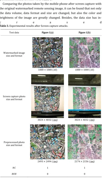
According to the parameter setting in Table 2, screen capture attacks are done on the two watermarked remote sensing images in Figure 3. The ex-perimental results are shown in Table 3.
Comparing the photos taken by the mobile phone after screen capture with the original watermarked remote sensing image, it can be found that not only the data volume, data format and size are changed, but also the color and brightness of the image are greatly changed. Besides, the data size has
[image:9.595.208.540.145.736.2]in-c r e a s e d
Table 3. Experimental results after Screen capture attacks.
Test data Figure 1(a) Figure 1(b)
Watermarked image size and format
1000 × 1000 (.tif) 1000 × 1000 (.tif)
Screen capture photo size and format
3024 × 4032 (.jpg) 3024 × 4032 (.jpg)
Preprocessed photo size and format
2493 × 2494 (.jpg) 2174 × 2156 (.jpg)
𝑁𝐶 1 1
DOI: 10.4236/jcc.2019.77003 26 Journal of Computer and Communications
Extracted QR code
Scanning result copyright protection Urban planning copyright protection Urban planning
from the original 1000 × 1000 to 3024 × 4032, and the data format has changed from .tif to .jpg. Then, the positioning and correction preprocessing of the screen capture is performed, and the amount of data is further reduced to 2493 × 2494 and 2174 × 2156. At this point, it can be intuitively seen that the screen capture by the mobile phone has made a great damage to the re-mote sensing image.
For all that, using the proposed algorithm, the extracted QR code could still be correctly identified. The NC between the extracted and original watermark information is 1, so that the BER is always 0. This indicates that lossless ex-traction of the watermark information could be carried out after the screen capture attack. The experimental analyses proved that the proposed algo-rithm has a high level of fidelity and robustness, and can effectively resist screen capture attack.
4. Conclusions
Remote sensing technology provides effective basic information for urban planning, and digital watermark technology provides security for urban plan-ning. In order to resist the screen capture attacks, the watermark information is encoded and converted, and combined with a circular angle template wa-termark, a digital watermarking algorithm based on QR Code and circular an-gle template is proposed. The algorithm replaces the binary sequence wa-termark information with the circular angle periodic pattern wawa-termark, and the watermark information is embedded with the JND value of the remote sensing image. Before the watermark information detection, Harris corner detection and perspective transformation are used to preprocess the detected data. In the process of watermark information detection, the angle in-formation is detected by steps such as winner filtering, calculating auto-correlation function, sharpening peak point, expansion and erosion, and Hough transform, and then the watermark information is obtained. The ex-perimental results show that the proposed algorithm can effectively resist the attacks caused by screen capture and provide technical support for data se-curity. At the same time, the algorithm has strong imperceptibility and prac-ticability.
DOI: 10.4236/jcc.2019.77003 27 Journal of Computer and Communications multi-technology fusion can help to plan cities with high efficiency, rationality and science, so as to realize the intelligent development of urban planning information management. In the future research work, a more practical digi-tal watermarking algorithm can be designed to protect data security for the specific application scenarios of urban planning information management.
Conflicts of Interest
The authors declare no conflicts of interest regarding the publication of this paper.
References
[1] Wang, J.Y. (2004) Spatial Information System Theory. Science Press, Beijing. [2] Han, P.P. (2018) Application Analysis of Remote Sensing Information
Technolo-gy in Urban Planning. Urban Construction Theory Rereaearch, No. 17, 77. [3] Cui, L.N., Gong, W.P. and Hao, H. (2012) Study the Result of Remote Sensing
Monitoring Supported Urban Planning Supervision. Urban Studies, 19, 140-144. [4] Kan, M.Z., Li, W. and Liu, J.G. (2012) An Overview of the Application of High
Res-olution Satellite Remote Sensing Technique in Urban Planning and Management. Geomatics & Spatial Information Technology, No. S1, 100-102.
[5] Chen, C.H., Tang, Y.L. and Hsieh, W.S. (2013) Print-and-Scan Resilient Water-marking through Polarizing DCT Coefficients. IEICE Transactions on Information and Systems, 96, 2208-2214.
[6] Amiri, S.H. and Jamzad, M. (2014) Robust Watermarking against Print and Scan Attack through Efficient Modeling Algorithm. Signal Processing Image Commu-nication, 29, 1181-1196.https://doi.org/10.1016/j.image.2014.07.004
[7] Xie, Y., Tan, H.H., Wang, K.L., et al. (2016) Color Image Watermark Algorithm Robust to the Print-and-Scan Process. Packaging Engineering, No. 13, 151-156. [8] Liao, T. and Li, Z.J. (2016) Adaptive Print-Scan Resilient Image Watermarking
Based on Fourier Transform. Journal of Applied Sciences—Electronics and In-formation Engineering, 34, 309-316.
[9] Lee, M.L., Ting, P.Y. and Wu, T.S. (2015) Photograph Watermarking. Multimedia
Tools & Applications, 75, 16173-16189.
https://doi.org/10.1007/s11042-015-2925-6
[10] Gourrame, K., Douzi, H., Harba, R., et al. (2016) Robust Print-Cam Image Water-marking in Fourier Domain. International Conference on Image and Signal Pro-cessing, Springer, Cham, 356-365.
https://doi.org/10.1007/978-3-319-33618-3_36