ISSN Online: 1945-3108 ISSN Print: 1945-3094
DOI: 10.4236/jwarp.2019.116039 Jun. 10, 2019 675 Journal of Water Resource and Protection
Drainage Management Problems Evaluation:
Case Study Baloza and EL-Farama Drains, North
Sinai, Egypt
Mohamed Gabr
Civil Engineering Department, High Institute for Engineering and Technology, New Damietta, Egypt
Abstract
Drainage management activities aim at maintaining the performance of drai-nage networks by assessing the major draidrai-nage madrai-nagement problems re-garding sedimentation, bank erosion, vegetation, water quality, and biodiver-sity, to find appropriate solutions for channel improvement in order to in-crease agricultural productivity and maintain agricultural land and the sur-rounding environment. In this research, we evaluate the drainage manage-ment problems to the surface drains Baloza and EL-Farama in the cultivated Tina Plain region (21,000 hectares) North Sinai, Egypt to provide an accurate data to help decision-makers to know the status of maintenance of the wa-tercourses and the need for improvement. For this, Intensive field investiga-tions were carried out regarding a hydrographic survey of the actual drains cross-section using total station and aqua sounder devices, visual stream bank erosion survey, and vegetation survey. In addition, monthly water samples from the drainage water were treated and analyzed for physical and chemical, bacteriological related indices. The results showed, the studied drains suffer from sedimentation, vegetation infection, and bank erosion in some reaches and need remedy. Estimated sedimentation in EL-Farama Drain was 34369
m3/year and in Baloza Drain 29153 m3/year; bank slope failures upstream and
downstream pump stations were recorded; the average weed infection ratio for both drains was 30%. The results of water quality parameters showed ac-ceptable concentrations for BOD, DO, NO3, and total coliform according to Egypt decree, 92/2013 for the protection of the Nile River and its waterways from pollution, except TDS (more than 10,000 mg/L). The drainage water
was classified as high saline and it was unacceptable for irrigation.Therefore,
the author recommends to remove sedimentation and vegetation every 2 years by mechanical methods, applying gabions lining to prevent bank ero-sion, and treating drainage water using wetland system and utilizing the treated wastewater in fish farming.
How to cite this paper: Gabr, M. (2019) Drainage Management Problems Evalua-tion: Case Study Baloza and EL-Farama Drains, North Sinai, Egypt. Journal of Wa-ter Resource and Protection, 11, 675-689.
https://doi.org/10.4236/jwarp.2019.116039
Received: July 18, 2018 Accepted: June 7, 2019 Published: June 10, 2019
Copyright © 2019 by author(s) and Scientific Research Publishing Inc. This work is licensed under the Creative Commons Attribution International License (CC BY 4.0).
DOI: 10.4236/jwarp.2019.116039 676 Journal of Water Resource and Protection
Keywords
Drainage Management, Sedimentation, Vegetation, Water Quality, Surface Drains
1. Introduction
Drainage management activities are to keep drain systems functioning effective-ly and efficienteffective-ly. Adequate drainage system, increases land productivity, and protects the environment. Drainage management major related problems were
dealt with, sedimentation, vegetation, water quality, and biodiversity [1] [2] [3].
Sediment is a fertile environment for vegetation growth, especially in the case of freshwater. Brackish or muddy water during flood season has a severe effect on
stream life and other water use (domestic supply, stock watering) [4] [5]. Three
sources of sediments should be taken into consideration when we deal with se-dimentation management: 1) Upland erosion caused by surface washed processes,
concentrated flow and mass [6]. 2) Stream bed erosion where the forces of water
are capable of removing bed material [7]. 3) Stream bank erosion where the
wa-ter flowing over or through the stream bank and the discharge of concentrated
runoff from other sources is enough to remove bank material [8]. Vegetation
management activities increase channel hydraulic efficiency, and reduce channel bank erosion. Plant growth depends on many factors such as light, temperature, nutrient levels, both in the water column and in streambed sediments, and hy-drologic regime. High levels of nutrients are increasing aquatic weed growth. Plant influence of the amount of sunlight fluctuated as it effects on the rates of
photosynthesis and growth [9] [10] [11]. The velocity of flowing water effects on
aquatic plants intensity and distribution, where more weeds are existing on slower moving water. Water quality problems are, polluted agriculture surface and subsurface drainage water, natural and constructed drainage networks
which become sinks for several sediments and contaminants [12]. Water quality
problems include high dissolved solids, low dissolved oxygen, high nutrient le-vels, high turbidity, high rates of trace elements, and biological contaminants
[13]. Biodiversity problems relate to the polluted water in the new drains, cutoff,
oxbow lakes of meanders, and wetlands agriculture development; it has a nega-tive impact on the fish populations, plant communities, and many diverse ani-mals. Therefore optimum drainage management mitigates the contamination
and adversely effects on animal and aquatic life ecosystems [14]. Nowadays, due
to the degradation of water resources and limitation, there is not much opportu-nity for increasing the total irrigated region; the common of the increase in out-put from irrigated agriculture will have to emanate from investments in
devel-oped irrigation and drainage practices in current agricultural areas [15] [16]
[17]. Drainage is not only a tool to battle soil salinity and waterlogging but also it
plays a main role in the preservation of investments in irrigation, promoting
economic growth, and ensuring the sustainability of irrigated agriculture [18]
DOI: 10.4236/jwarp.2019.116039 677 Journal of Water Resource and Protection 21000 hectares; the surface drains Baloza and EL-Farama bound the area from the south and north respectively. The North Sinai Sector for water resources and infrastructures, Ministry of Water Resources and Irrigation operates and man-ages the irrigation and drainage networks in the Tina Plain area since 1998. Therefore, the study of the drainage channel problems relating to sedimentation, vegetation, and water quality for the agriculture main drains Baloza and EL-Farama are needed to understand the processes taking place on-site to help decision-maker to apply sustainable agriculture drainage system. Therefore, in this research, we assess the major drainage channel problems relating to sedimen-tation, vegesedimen-tation, and water quality for the agriculture main drains Baloza and EL-Farama, we assess the status of maintenance of the studied drains based on the measure of the drains actual cross-sections by hydrographic surveying, and survey vegetation infection. In addition, we assess the drainage water quality, we collect, treat, and analyze water samples from four locations in studying drains for all im-portant water quality parameters total salinity (TDS, EC), temperature, pH, organ-ics (DO, BOD), nutrients (NO3), major anions (Ca, Mg, Na, K), major cations (HCO3, CO3, Cl, SO4), and pathogenicity (Total Coli.).
2. Materials and Methods
2.1. Description of the Study Area
The study area is located in the north Sinai, Egypt, where the North Sinai De-velopment Project (NSDP) to reclaim and cultivate 168,000 hectares. The surface drains Baloza and EL-Farama are bounded the cultivated Tina Plain region
(21,000 hectares) from south and north respectively (Figure 1). The Tina Plain
region is a part of the Nile Delta, it is characterized by being flat topography with mean elevations of 1.0 m above mean sea level, and the predominate soil is clay
[21]. The irrigation and drainage networks were operated and managed by the
North Sinai Sector for Water Resources and Infrastructures (SWRI), Ministry of Water Resources and Irrigation (MWRI) since 1998. El-Sheikh Gaber Channel is
the main irrigation channel in the NSDP, its discharge is 160 m3/sec, and the
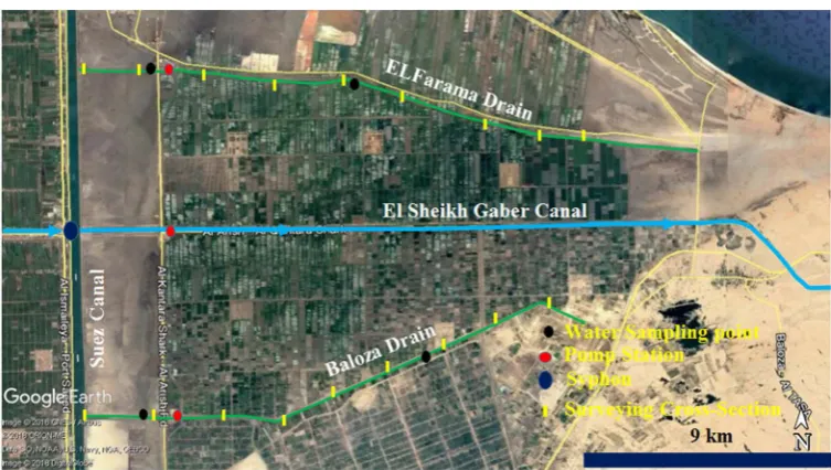
DOI: 10.4236/jwarp.2019.116039 678 Journal of Water Resource and Protection Figure 1. Location of Baloza and El-Faram drains in Tina Plain.
an area of 8400 hectares, the drain length is 17.480 km, bed width varying from 2.0 m at the entrance to 10 m at the outlet with water depths 1.22 m to 1.97 m respectively, and the inside slope is 3:1. At the drain outlet, a pump station exists at 3.500 km, to pump the drainage water into the Suez Channel through a carrier
channel of 3.0 km length [22].
2.2. Hydrographic Survey
To examine the changes in the drain cross-section with respect to the designed cross-sections, groups of 18 cross-sections are distributed along the studied drains were selected according to, existing vegetation and existing hydraulic
structures (Figure 2). The drains cross-sections were measured three times in
DOI: 10.4236/jwarp.2019.116039 679 Journal of Water Resource and Protection Figure 2. Hydrographic survey cross-sections locations and water sample locations.
with the designed ones, and the annual rate of sediments as a ratio of the de-signed cross-section area every 6 months is determined, additional details on the
hydrographic survey are provided on [22].
2.3. Monitoring the Aquatic Weeds
A survey to measure the vegetation infection for the studied drains are carried out using a total station survey device; additional details on vegetation are
pro-vided in [22].
2.4. Drainage Water Samples Collection and Analysis
Water samples are collected every month from four monitoring locations, two locations in Baloza Drain, at N30˚57'29.81'', E32˚20'56.95'' (downstream pump station at 3.500 km from drain outlet), and at 2N30˚59'16.16'', E32˚28'7.94'' (13.500 km from drain outlet). In addition, two locations in EL-Farama drain at N31˚4'21.91'', E32˚20'46.91'' (downstream pump station at 3.500 km from drain outlet) and N31˚4'18.32'', E32˚21'39.01'' (13.500 km from drain outlet) during
the period from 2010 to 2014 (Figure 2). When taking water samples principles
in [23] were considered. Total salinity (Electrical Conductivity (EC), total
dis-solved solids (TDS)), temperature, pH, were measured in situ. These parameters were measured using portable electrodes (Loveland). The rest of parameters, or-ganics (DO, BOD), nutrients (NO3), soluble ions (Ca, Mg, Na, K, HCO3, CO3, Cl, SO4), and pathogenicity (Total Coli.) were determined at the Center Laborato-ries for Environmental Quality Monitoring, National Water Research Center, Ministry of Water Resources and Irrigation, Cairo, Egypt.
DOI: 10.4236/jwarp.2019.116039 680 Journal of Water Resource and Protection sodium levels in irrigation water to maintain soil structural stability) are deter-mined to assess the suitability of drainage water to reuse in irrigation. To protect the non-fresh water resources, in case of discharging the drainage water into the sea, the measured drainage water parameters were compared with the Egyptian standards decree 92/2013, Executive Regulation of Law 48/1982 that protects
non-fresh watercourses from pollution by the discharged effluents [24].
Addi-tional details on the study of water quality for Baloza and EL-Farama drains are
provided in [25].
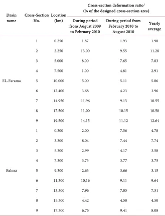
Table 1, summarizes the calculated average annual cross-section
deforma-tion as a ratio of the designed cross-secdeforma-tion for the period from August 2009 to February 2010 and from February 2010 to 2010 August for the studied drains,
it shows sedimentation in all measured cross-sections. Figure 3 shows the
cross-section deformation as a ratio of the designed cross-section area along EL-Farama drain path, the critical sedimentation reaches are from 0.250 km to 2.250 km and from 14.950 km to 19.50 km where, the reduction in the designed cross-section area ranges from 10.55% to 12.64% and 1.98 % to 11.8% respec-tively. The total calculated annual sedimentation in EL-Farama Drain is 34,369
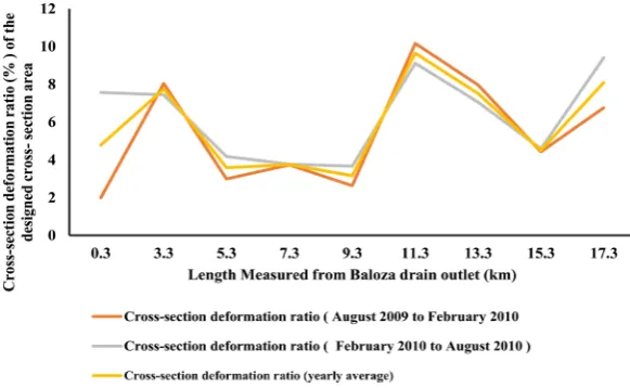
m3. Figure 4 shows the cross-section deformation as a ratio of the designed
cross-section area along Baloza Drain path the critical sedimentation reaches are from 0.300 km to 3.300 km and from 11.300 km to 13.300 km, the reduction in the designed cross-section area ranges from 9.64% to 7.51% and 4.785 % to
7.74% respectively. The estimated total annual sedimentation is 29,153 m3. The
increasing in sedimentation rates for the previous reaches are due to windblown during March month loaded with fine sands, coming from northern north west
direction [21] [26]. The fallen sand inside watercourse reduces its cross section
area, which so decreases storage capacity, constitutes a good environment for the growth of aquatic weeds, and effect on water quality, and reduces the hydraulic efficiency. Windbreakers of wooden trees (Casuarina and Equistifofia) of a ma-trix of one row can be used to reduce the fallen sand rates in the studied drains [21].
3. Results and Discussions
3.1. Drains Cross-Section Area Deformation
Table 1, summarizes the calculated average annual cross-section deformation as
a ratio of the designed cross-section for the period from August 2009 to Febru-ary 2010 and from FebruFebru-ary 2010 to 2010 August for the studied drains, it shows
sedimentation in all measured cross-sections. Figure 3 shows the cross-section
deformation as a ratio of the designed cross-section area along EL-Farama drain path, the critical sedimentation reaches are from 0.250 km to 2.250 km and from 14.950 km to 19.50 km where, the reduction in the designed cross-section area ranges from 10.55% to 12.64% and 1.98 % to 11.8% respectively. The total
calcu-lated annual sedimentation in EL-Farama Drain is 34,369 m3. Figure 4 shows
DOI: 10.4236/jwarp.2019.116039 681 Journal of Water Resource and Protection Baloza Drain path the critical sedimentation reaches are from 0.300 km to 3.300 km and from 11.300 km to 13.300 km, the reduction in the designed cross-section area ranges from 9.64% to 7.51% and 4.785 % to 7.74% respectively. The estimated
total annual sedimentation is 29,153 m3. The increasing in sedimentation rates
for the previous reaches are due to windblown during March month loaded with
fine sands, coming from northern north west direction [21] [26]. The fallen sand
inside watercourse reduces its cross section area, which so decreases storage ca-pacity, constitutes a good environment for the growth of aquatic weeds, and ef-fect on water quality, and reduces the hydraulic efficiency. Windbreakers of wooden trees (Casuarina and Equistifofia) of a matrix of one row can be used to
[image:7.595.208.538.282.712.2]reduce the fallen sand rates in the studied drains [21].
Table 1. Calculated average annual cross-section deformation as a ratio of the designed cross-section area.
Drain
name Cross-Section No. Location (km)
Cross-section deformation ratio1 (% of the designed cross-section area)
During period from August 2009
to February 2010
During period from February 2010 to
August 2010
Yearly average
EL-Farama
1 0.250 1.87 1.93 1.90
2 2.250 13.00 9.55 11.28
3 5.000 8.00 7.65 7.83
4 7.500 1.00 4.81 2.91
5 10.000 5.00 5.11 5.06
6 12.400 3.68 4.23 3.96
7 14.950 11.96 9.13 10.55
8 17.500 11.00 10.15 10.58
9 19.500 14.15 11.12 12.64
Baloza
1 0.300 2.00 7.56 4.78
2 3.300 8.04 7.44 7.74
3 5.300 2.99 4.17 3.58
4 7.300 3.73 3.77 3.75
5 9.300 2.63 3.66 3.15
6 11.300 10.16 9.11 9.64
7 13.300 7.96 7.05 7.51
8 15.300 4.42 4.58 4.50
9 17.300 6.75 9.41 8.08
DOI: 10.4236/jwarp.2019.116039 682 Journal of Water Resource and Protection Figure 3. EL-Farama Drain, calculated average annual cross-section deformation (sedi-mentation) as a ratio of the designed cross-section area.
Figure 4.Baloza Drain, calculated average annual cross-section deformation (sedimenta-tion) as a ratio of the designed cross-section area.
3.2. Vegetation Infection
Table 2 summarizes weeds types and its infection percentage in the studied
drains. Looking at Table 2, the weed infection ratio for Baloza Drain at the reach
from 0.00 km to 3.30 km is 30%, the reach from 0.00 km to 3.30 km is 40%, the reach from 5.50 km to 7.0 km is 30%, and the reach from 7.00 km to 9.30 km the
weed infection ratio is 20%. The Phragmites australis, Cyperus articulates and
Ceratophyllum demersum were the exiting vegetation. For EL-Farama Drain the
reach from 0.00 km to 3.00 km the weed infection ratio is 30%, Phragmites
aus-tralis, Cyperus articulates, and Ceratophyllum demersum were the exiting vege-tation. Vegetation is the extension of plant diversity of the Damietta Branch,
River Nile, Egypt [27].
3.3. Bank Erosion
[image:8.595.226.517.291.470.2]DOI: 10.4236/jwarp.2019.116039 683 Journal of Water Resource and Protection Table 2. Weeds types and its infection percentage the studied drains.
Drain name Cross-Section No. Weed infection ratio (%) Types of exiting vegetation
Baloza Drain 0.00 km - 3.30 km 30 Phragmites australis, Cyperus articulates and Ceratophyllum demersum 3.30 km - 5.50 km 40
5.50 km - 7.00 km 30 7.00 km - 9.30 km 20
EL-Farama Drain 0.00 km - 3.00 km 30 Phragmites australis, Cyperus articulates and Ceratophyllum demersum
and down steam pump stations. The soil analysis for drains bed and banks [22]
showed that the soil classification for El-Faram Drain soil classification at the bed at 0.250 km was silty clay, at right bank 7.500 km was silty sand, and at right bank, 7.500 km was silty clay. For Baloza Drain soil classification is sandy soil. Lining of the drains inside slopes with riprap or gabions was recommended to
prevent bank erosion [28].
3.4. Methodology for Channel Maintenance Method
To identify the channel priority to be maintained the following steps are essential: Step 1: Define the related geometry and features of the channel
Based on the national database for the Egyptian Ministry of Water Resources and Irrigation (MWRI) the geometry of the cross-section, the bed slope of the reach, and the type of vegetation, which defines the roughness coefficient, are determined for all the main watercourses in Egypt. The national database is used to obtain this information, although it is acknowledged that local information, when available, may provide more reliable and accurate inputs.
Step 2: Describe maintenance scenarios (Comprising sediment and vege-tation management)
Maintenance scenarios depend on characteristics of the watercourse, and the results of sedimentation and vegetation surveying.
Step 3: Compute the impact of maintenance
The variation in the conveyance capacity of the main channel (expressed as a percentage) is utilized to compute the impacts of maintenance. This parameter estimates for all watercourses in order to deliver a simple and reliable measure of the impacts of maintenance works.
Step 4: Detecting the ideal management option
DOI: 10.4236/jwarp.2019.116039 684 Journal of Water Resource and Protection is the one with the largest ratio in the case of dredging, it is not possible to state the cost of the works at the national level due to the large differences depending on the features of the site. The costing of this type of works also requires to take into consideration the disposal of material off-site, which could have large varia-tions. We suggest a maintenance program for the studied drains to remove the sedimentation and vegetation every 2 years from the most exposed reaches by
utilizing a hydraulic excavator with a long boom (Table 3).
3.5. Drainage Water Quality
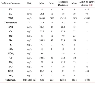
Analytical results for the chemical, physical, and bacteriological water quality parameters including statistical analysis, such as maximum, minimum, mean
[image:10.595.58.541.285.394.2]and standard deviation are summarized in Table 4 & Table 5 for Baloza and
Table 3. Suggested maintenance program for the studied surfaces drains
Watercourse
Maintenance Type
Vegetation Removing Sedimentation Removing
Procedure Machine Annual rate Procedure Machine Annual rate
Baloza Drain Mechanical Hydraulic Excavator with long
boom and vegetation cutting bucket 1/2 (Every 2 years) MechanicalHydraulic Excavator with long boom and sedimentation dredging bucket 1/2 (Every 2 years) EL-Farama
Drain Mechanical Hydraulic Excavator with long boom and vegetation cutting bucket 1/2 (Every 2 years)MechanicalHydraulic Excavator with long boom and sedimentation dredging bucket 1/2 (Every 2 years)
Table 4. Summary statistics water quality parameters in Baloza drain for the two moni-toring sites from 2010 to 2014 compared to limit by Egypt decree [24].
Indicator/measure Unit Max. Min. Deviation Mean Standard Limit by Egypt decree [24]
PH - 8 8 0.1 8 6 - 9
EC ds/m 29.1 12 6.8 19 7.8
TDS mg/L 18633 7680 4343.1 12464 <5000
Temperature ˚C 23.1 15 2.7 20 >3
SAR mg/L 88.6 20 20.4 43 -
Ca mg/L 53.2 9 12.1 22
-Mg mg/L 37 12 7.0 23 -
Na mg/L 333.9 85 71.4 164 -
K mg/L 3.1 1 0.7 2 -
CO3 mg/L 0 0 0 0 -
HCO3 mg/L 6.9 2 1.4 4 -
Cl mg/L 322.6 82 71.4 174 -
SO4 mg/L 52 11 11.7 35 -
DO mg/L 7.8 4 1.0 6 >5
BOD mg/L 13.8 6 2.1 11 <60
NO3 mg/L 5.7 3 1.0 4
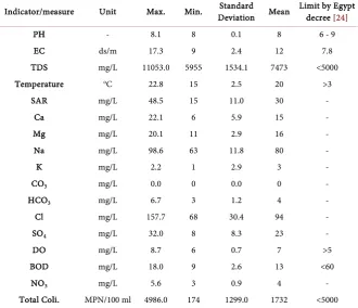
[image:10.595.208.538.436.731.2]DOI: 10.4236/jwarp.2019.116039 685 Journal of Water Resource and Protection Table 5. Summary statistics water quality parameters in EL-Farama drain for the two monitoring sites from 2010 to 2014 compared with the limit by Egypt decree [24].
Indicator/measure Unit Max. Min. Deviation Mean Standard Limit by Egypt decree [24]
PH - 8.1 8 0.1 8 6 - 9
EC ds/m 17.3 9 2.4 12 7.8
TDS mg/L 11053.0 5955 1534.1 7473 <5000
Temperature oC 22.8 15 2.5 20 >3
SAR mg/L 48.5 15 11.0 30 -
Ca mg/L 22.1 6 5.9 15
-Mg mg/L 20.1 11 2.9 16 -
Na mg/L 98.6 63 11.8 80 -
K mg/L 2.2 1 2.9 3 -
CO3 mg/L 0.0 0 0.0 0 -
HCO3 mg/L 6.7 3 1.2 4 -
Cl mg/L 157.7 68 30.4 94 -
SO4 mg/L 32.0 8 8.3 23 -
DO mg/L 8.7 6 0.7 7 >5
BOD mg/L 18.0 9 2.6 13 <60
NO3 mg/L 5.6 3 0.9 4
-Total Coli. MPN/100 ml 4986.0 174 1299.0 1732 <5000
Table 6. Water classification by salinity.
Water quality grade EC (dS/m) (TDS mg/L)
Non-saline water <0.7 <500
Saline water 0.7 - 42 500 - 3000
Slightly saline 0.7 - 3.0 5000 - 2000
Medium saline 3 - 6 2000 - 4000
Highly saline >6.0 >4000
Very saline >14 >9000
Brine >42 >30,000
FAO, 2007 [29].
EL-Farama Drains respectively. For Baloza Drain water temperature ranges from 15˚C to 23.1˚C with an average of (20 ˚C ± 2.7˚C), pH is (8 ± 0.1) indicating al-kaline water. TDS ranges from 7680 mg/L to 18,633 mg/L with an average (12,464 ± 4343.1) mg/L, TDS is unacceptable according to Egyptian local low Egyptian decree 92/2013. The drainage water quality classifies as a high saline
according to [29] (Table 6). EC ranges from 12 to 29.1 dS/m with an average (19
± 6.8) mg/L indicating high saline water. SAR is calculated using the formula
presented in [29], it ranges from 20 to 88.6 mg/L with an average (43 ± 20.4)
[image:11.595.208.539.419.546.2]DOI: 10.4236/jwarp.2019.116039 686 Journal of Water Resource and Protection ranges from 6 to 13.8 mg/L with an average (11 ± 2.1) mg/L indicates acceptable
BOD < 60 mg/L according to [24]. NO3 ranges from 3 to 5.7 mg/L with an
aver-age (4 ± 1) mg/L. In addition, the Total Coli. ranges from 174 to 4986 in MPN/100 ml with an average of (1524 ± 1218.7) in MPN/100 ml acceptable
ac-cording to [24]. The abundance of cations in the drainage water is in the
follow-ing order: Na+ > Mg2+ > Ca2+ > K+. The concentrations of cations are (80 ± 11.8)
mg/L, (16 ± 2.9) mg/L, (15 ± 5.9) mg/L, and (3 ± 2.9) mg/L mg/L for Na+, Mg2+,
Ca2+, and K+ respectively. Chloride is the dominant anion, followed by sulfate
and bicarbonate. The average concentrations of the anions Cl, SO4, and HCO3 are (174 ± 71.4) mg/L, (35 ± 11.7) mg/L, and (4 ± 1.4) mg/L respectively. For EL-Farama Drain temperature ranges from (14.9˚C to 22.9˚C) with an average (19.9˚C ± 2.6˚C), pH ranges from 7.8 to 7.9 with an average (7.9 ± 0.1) indicates alkaline water. TDS ranges from 7680 mg/L to 9612 mg/L with an average (8774 ± 681.7) mg/L, TDS is unacceptable according to Egyptian local decree 92/2013
[24] and the drainage water quality classify as a high saline (Table 6) [29]. EC
ranges from 12 to 15 dS/m with an average (13.7 ± 1.1) indicate high saline wa-ter. SAR ranges from 20.2 to 54.3 mg/L with an average (33 ± 12.1) mg/L indi-cates slight reduction potential infiltration problem. DO ranges from 4.5 to 6.7 mg/L with an average (5.5 ± 0.9) indicates good dissolved oxygen, BOD ranges from 10 to 13.2 mg/L with an average (11.7 ± 1.1) mg/L indicates acceptable BOD < 60 mg/L. NO3 ranges from 2.8 to 5.4 mg/L with an average (3.8 ± 0.9) mg/L and the Total Coli. ranges from 275 to 3957 in MPN/100ml with an
aver-age of (2330.4 ± 1206) in MPN/100 ml, it is acceptable according to [24]. The
abundance of cations in the drainage water is in the following order: Na+ >
Mg2+ > Ca2+ > K+. The average concentrations of cations averages are (107.2 ±
21.5) mg/L, (17.7 ± 4.3) mg/L, (16.3 ± 6.5) mg/L, and (1.5 ± 0.4) mg/L mg/L for
Na+, Mg2+, Ca2+, and K+ respectively. Chloride is the dominant anion, followed
by sulfate and bicarbonate. The average concentrations of the anions Cl, SO4, and HCO3 are (114.5 ± 24.8) mg/L, (28.7 ± 11.1) mg/L, and (3.3 ± 0.7) mg/L re-spectively.
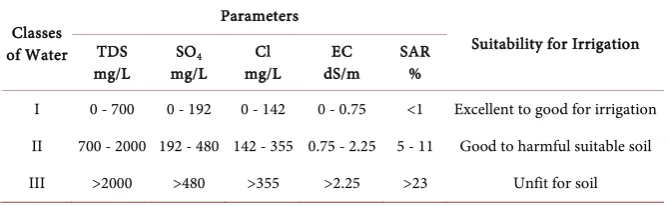
Suitability of drainage water for irrigation
The general criteria for assessing the drainage water quality to be used in irri-gation are based on the total concentration of dissolved salts (TDS); relative proportion of sodium to other principal cations, the relative proportion of bi-carbonate to calcium and magnesium, and elements that may be toxic (sulfates
concentration and chloride concentration) (Table 7) reflect high saline water.
According to [29] [30] Baloza drainage water is unacceptable for irrigation.
4. Conclusions and Recommendations
DOI: 10.4236/jwarp.2019.116039 687 Journal of Water Resource and Protection Table 7. Water quality for irrigation.
Classes of Water
Parameters
Suitability for Irrigation TDS
mg/L mg/L SO4 mg/L Cl dS/m EC SAR %
I 0 - 700 0 - 192 0 - 142 0 - 0.75 <1 Excellent to good for irrigation II 700 - 2000 192 - 480 142 - 355 0.75 - 2.25 5 - 11 Good to harmful suitable soil III >2000 >480 >355 >2.25 >23 Unfit for soil Kumar, et al. 2007 [30].
bank erosion, vegetation, and water quality were investigated for the surface drains Baloza and EL-Farama in the cultivated Tina Plain region (21,000 hectares) North Sinai, Egypt. The summarized conclusions are as follows. The studied drains suffer from sedimentation, vegetation infection, and bank erosion in some reaches and need remedy. The choice of the ideal maintenance option is based on the highest impacts on conveyance management and highest benefits associated to the water-course. High measured annual sedimentation volume for EL-Farama drain is
34,369 m3/year. High measured annual sedimentation volume for Baloza is 29,153
m3/year. Measured average weeds infection ratio is 30%. Bank slope failures
up-stream and downup-stream pump stations were recorded. The average weed infection ratio for both drains is 30%. Drainage water quality classifies as high saline water, BOD, DO, NO3, and total coliform at the permitted limits of the Egypt decree (92/2013), except for TDS (more than 10,000 mg/L). Therefore, Baloza and El-Farama drainage water is unacceptable for reusing in irrigation. Thus, for sus-tainable drainage management we suggest a maintenance program to remove se-dimentation and vegetation every 2 years from the most exposed reaches utilizing a hydraulic excavator with a long boom, applying gabions lining to prevent bank erosion, and treating drainage water using constructed wetland systems.
Acknowledgements
I am thankful for the logistical and technical support provided by the Sector of Water Resources, Irrigation and Infrastructures, North Sinai, Ministry of Water Resources and Irrigation (MWRI), Egypt, and the Egyptian Channel Mainten-ance Research Institute (CMRI), National, (MWRI). During the research period, the author was a senior engineer in the Studies and Design Directorate, Sector of Water Resources, Irrigation and Infrastructures, North Sinai, MWRI, supervis-ing the study of assesssupervis-ing of the irrigation and drainage network maintenance at the North Sinai Project, North Sinai.
Conflicts of Interest
The author declares no conflict of interest.
References
Sus-DOI: 10.4236/jwarp.2019.116039 688 Journal of Water Resource and Protection tainable Drainage Management—Field Guide. Wellington.
[2] Walter, O. and Hervé, P. (2005) Water Resources and Environment Technical Note E.1, Irrigation and Drainage Development. International Bank for Reconstruction and Development, the World Bank, Washington DC.
[3] Essex County Council Environment (ECC) (2016) Sustainable Drainage Systems Design Guide. Sustainability & Highways. http://www.essex.gov.uk/flooding [4] Arcement, G.J. and Schneider, V.R. (1989) Guide for Selecting Manning’s
Rough-ness Coefficients for Natural Channels and Flood Plains. United States Geological Survey Water Supply, Paper 2339.
[5] Peter, C. and Scott, M. (1984) Stream Bank Erosion Protection and Channel Scour Manipulation Using Rock fill Dikes and Gabion. Water Resources Research Insti-tute Oregon State University, Corvallis, WRRI-98, PAP-734.
[6] King County Department (KCD) of Public Works Surface Water Management Di-vision (1993) Guide Lines for Bank Stabilization Projects: In Riverine Environments of King County. Seattle.
[7] Steve, J. (2002) Stream Channel and Floodplain Erosion. Water and Rivers Com-mission, Hyatt Centre, East Perth, Western Australia, Report No. RR18.
[8] Iowa Department of Natural Resources (IDNR) in Cooperation with the Natural Resources Conservation Service (2006) How to Control Streambank Erosion Iowa Department of Natural Resources. U.S. Department of Agriculture, Washington DC.
[9] Siwan, L. and Phil, P. (1999) Riparian Land Management Technical Guidelines. Volume One: Principles of Sound Management. Land and Water Resources Re-search and Development Corporation (LWRRDC), Canberra.
[10] U.S. Army Corps of Engineers (USACE) (2007) White Paper: Treatment of Vegeta-tion within Local Flood-Damage-ReducVegeta-tion Systems. Washington DC.
[11] U.S. Army Corps of Engineers (USACE) (2014) Guidelines for Landscape Planting and Vegetation Management at Levees, Floodwalls, Embankment Dams and Ap-purtenant Structures. Engineering Technical Letter (ETL) 1110-2-583, Washington DC.
[12] Kostas, V. and Dimitra, V. (2012) Water Quality Monitoring and Assessment. In-Tech, Rijeka.
[13] Department of Environment and Heritage Protection (DEHP), Department of Science, Information Technology and Innovation, Environmental Protection, Water Policy (2017) Monitoring and Sampling Manual Sampling Design and Preparation Version. Consultation DRAFT, Queensland Government.
[14] Neil, A., Michael, V., Lloyd, F., Kevin, W. and Jessica, D. (2013) Alternative Tech-nology for Storm Water Management the South African Guidelines for Sustainable Drainage Systems. Report to the Water Research Commission by University of Cape Town, Cape Town, WRC Report No. TT 558/13.
[15] Muema, F.M., Home, P.G. and Raude, J.M. (2018) Application of Benchmarking and Principal Component Analysis in Measuring Performance of Public Irrigation Schemes in Kenya. Agriculture, 8, 162.https://doi.org/10.3390/agriculture8100162 [16] Schultz, B., Thatte, C.D. and Labhsetwar, V.K. (2015) Irrigation and Drainage: Main
Contributors to Global Food Production. Irrigation and Drainage, 54, 263-278.
https://doi.org/10.1002/ird.170
DOI: 10.4236/jwarp.2019.116039 689 Journal of Water Resource and Protection Institute for Water Education, Wageningen.
[18] Scheumann, W. and Freisem, C. (2002) The Role of Drainage for Sustainable Agri-culture. Journal of Applied Irrigation Science, 37, 33-61.
[19] Ritzema, H.P., Satyanarayana, T.V., Raman, S. and Boonstra, J. (2008) Subsurface Drainage to Combat Water-Logging and Salinity in Irrigated Lands in India: Les-sons Learned in Farmers’ Fields. Agricultural Water Management, 95, 179-189.
https://doi.org/10.1016/j.agwat.2007.09.012
[20] Nijland, H.J. (2000) Drainage along the River Nile. RIZA Nota, Lelystad, 323 p. [21] Mohamed, G. (2018) Magnitude and Characteristics of Sand Dunes Encroachment
towards El-Sheikh Gaber Channel, North Sinai, Egypt. 21st International Water
Technology Conference, Ismailia, 28-30 June 2018, 43-47.
[22] Channel Maintenance Research Institute, National Water Research Center, Ministry of Water Resources and Irrigation (MRWI) (2010) Assessing of the Irrigation and Drainage Network Maintenance at the North Sinai Project. Technical Report sub-mitted to the Sector of Irrigation, Water Resources and Infrastructures in the North of Sinai. Channel Maintenance Research Institute, El-kanater El-khairia, MWRI, Egypt. (In Arabic)
[23] APHA, AWWA, and WEF (2012) Standards Methods for the Examination of Water and Wastewater. 22nd Edition, Washington DC.
[24] Egypt Decree, 92/2013 for the Protection of the Nile River and Its Waterways from Pollution. Decree of Minister of Water Resources and Irrigation No. 92 for Year 2013 for the Executive Regulation of Law 48/1982, 92/2013, FAO, FAOLEX. https://www.mwri.gov.eg/index.php/ministry/ministry-17/12-1985
[25] Drainage Research Institute (DRI), National Water Center, Ministry of Water Re-sources and Irrigation (MRWI) (2015) Study of Water Quality in Sheikh Gaber Canal, East South EL-Qantara Canal, Some Branch Canals, and Main Drains in the North Sinai Project (Final Report) for the Period from 2010 to 2014. Technical Re-port submitted to the Sector of Irrigation, Water Resources, and Infrastructures in the North of Sinai. DRI, El-kanater El-khairia, MWRI, Egypt. (In Arabic)
[26] Gad, A. (2016) Sand Dune Distribution and Related Impacts on Agricultural Re-sources of Sinai Peninsula, Egypt, Using Integrated Remote Sensing-GIS Tech-niques. Global Advanced Research Journal of Agricultural Science, 5, 42-50. [27] Yasser, A., Mahmoud, A. and Shaymaa, O. (2015) Plant Diversity of the Damietta
Branch, River Nile, Egypt: An Ecological Insight. Mesopotamia Environmental
Journal, 1, 109-129.
[28] Amrapalli, G. and Joel, S. (2013) River Bank Protection. CIVE 717.
[29] Phocaides, A. (2000) Technical Handbook on Pressurized Irrigation Techniques. FAO, Rome, 372.