JOURNAL OF FOREST SCIENCE, 62, 2016 (6): 264–268 doi: 10.17221/9/2016-JFS
Determining an optimal path for forest road construction
using Dijkstra’s algorithm
A. Parsakhoo, M. Jajouzadeh
Department of Forestry, Faculty of Forest Science, Gorgan University of Agricultural Sciences and Natural Resources, Gorgan, Iran
ABSTRACT: From an economic point of view a well-designed road path with the minimum construction cost is an
optimal path that can be found using Dijkstra’s algorithm. In this study Dijkstra’s algorithm that consisted of nodes and links was used to optimize the road path in a broadleaved forest. The lower the cost, the greater the chance that the link will get routed. The road construction cost depends on the length of links, longitudinal gradient of links, side slope of the terrain and unit cost of the link construction. In general, the construction cost of each link increased with increasing length of the link, side slope gradient and longitudinal gradient. The total length and mean construc-tion cost of optimal path were 530 m and 18.18 USD·m–1, respectively. Based on the analysis, we found that Dijkstra’s algorithm is feasible in selecting an optimal path according to the construction cost of forest road.
Keywords: selecting path; nodes; links; Nahar Khvoran forest
The Hyrcanian forests are located in the north of Iran and on the south coast of the Caspian Sea, ex-tending from the coast to an altitude of 2,800 m of Alborz Mountain (Akbarimehr, Naghdi 2012). The area of these forests is about 1.8 million ha and 60% of these forests are known as wood production pole-stage stands (Tavankar 2013). Access to this commercial source for harvesting and conservation is provided by a forest road network (Kooshki et al. 2012). Forest transportation activities in the Hyrca-nian zone include log extraction from the stump to a depot and secondary transport by trucks on roads to a mill. This region requires a new and cost-effec-tive approach to manage roads and transportation network. Cheng and Chang (2001) developed a GIS-based network analysis system to automate the process of routing and design of a road. Dijkstra’s al-gorithm has been widely used in computers. In such algorithms, each node attempts to route over paths of minimum distance and updates the distances to adapt topology and traffic (Wang, Crowcroft 1992; Rogers 2005; Xie, Levinson 2006). Rees (2004) modelled the least-cost paths between the start and end points and then applied Dijkstra’s al-gorithm to find the least-cost routes from a variety
of starting points to a mountain summit. Devlin et al. (2008) used an ArcInfo network analyst tool (ESRI, Redlands, USA) to compare timber truck routes from forest harvesting site to mill in Ireland. It was found that the GPS routes were over 90% similar with what was generated by Dijkstra’s rout-ing algorithm within the GIS (ESRI, Redlands, USA). Ilayaraja (2013) determined the shortest path for three different scenarios between any two points within the road network using Dijkstra’s algorithm in Quantum GIS (QGIS Development Team, Essen, Germany). This dataset can be used for transport management by various organizations. Therefore, careful planning and analysis of paths is an ongoing task and necessary for minimizing the environmen-tal impact (Wang et al. 2014).
few-er researches have been focused on road planning and analysing by computerized and mathematical algorithms. In Hyrcanian forests, the construction of forest roads is the most costly and environmen-tally harmful operation for the forest ecosystem. The construction cost for road path planning in logging operations is presented in this paper. Using Dijks-tra’s algorithm, it searches through area and analysis a connecting path that links nodes. Forest openness is related to the concept of accessibility and easiness to conduct skidding and transport operations using existing and new forest roads. One of the main goals of the manuscript is calculating and optimizing the road path for forest openness.
MATERIAL AND METHODS
District Two in the Nahar Khvoran forestry plan with an area of 1,902 ha is located in Golestan prov-ince and in watershed No. 85 (36°45'09'' to 36°50'10''N and 54°32'03'' to 54°29'35''E). The bedrock is com-posed of limestone and sandstone with an altitude ranging from 250 to 950 m a.s.l. The mixed deciduous forest is dominated by Parotia persica (de Candolle) C.A. von Meyer and Carpinus betulus Linnaeus and it was established on brown forest soil and on the slope less than 30%. The mean forest growing stock in the study area was 221 m3·ha–1. The forest is harvested by
a single tree selection cutting system according to the annual harvesting table. The region has the Mediter-ranean warm and moist climate. The mean annual precipitation is 649 mm while it is the lowest in July and August (Fig. 1).
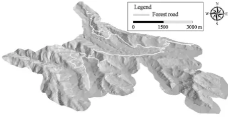
In this study Dijkstra’s algorithm was used for find-ing a forest path with minimum construction cost. First, the digital elevation model (DEM) of harvest-ing unit was prepared from a topographic map. The raster cells of DEM were considered as a grid with nodes and links. Nodes are placed on a regular grid and links that represent potential roads are projected to connect the nodes. Links with maximum length of 75 m are connected from a node to eight adjacent
nodes (Fig. 2). A set of links was created to connect one forest road from one node to another node. The procedure is repeated until all nodes are connected.
The total road construction cost (TRC) for road candidate k is calculated using Equation 1 (Con-treras, Chung 2007; Eq. 1):
TRCk RCi (1)
where:
TRCk – total road construction cost for road candidate
k (USD),
e – total number of links for road candidate k, RCi – road construction cost of the ith link (USD).
The road construction cost of the ith link (USD) is
calculated using Equation 2 (Contreras, Chung 2007; Eq. 2):
RCi = LDi × RC × LSi × SSi (2)
where:
LDi – length of the link (m),
RC – unit cost of road construction (USD·m–1; in this
study it was assumed RC = 16.22 USD·m–1),
[image:2.595.306.532.53.232.2]LSi – longitudinal road gradient factor, SSi – side slope factor (Table 1).
Fig. 2. A network created by the links and nodes for studied harvesting unit
Fig. 1. Position of the study area
𝑇𝑇𝑇𝑇𝑇𝑇𝑘𝑘= � 𝑇𝑇𝑇𝑇𝑖𝑖 𝑒𝑒
𝑖𝑖=1 (1)
[image:2.595.62.289.622.744.2]𝑇𝑇𝑇𝑇𝑖𝑖= 𝐿𝐿𝐿𝐿𝑖𝑖× 𝑇𝑇𝑇𝑇 × 𝐿𝐿𝐿𝐿𝑖𝑖× 𝐿𝐿𝐿𝐿𝑖𝑖 (2)
Table 1. Road gradient and side slope factors (Contreras, Chung 2007)
Road gradient Side slope (%) factor (%) factor
0–5 1.0 0–15 1.0
5–10 1.5 15–30 1.5
10–15 2.5 30–45 2.5
[image:2.595.307.531.666.755.2]The road gradient must be less than 12%. In the present study six road paths were designed in the shape of a network (Fig. 2). In a field survey, longi-tudinal road gradient and side slope gradient were measured using a clinometer.
RESULTS
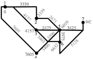
In this study Dijkstra’s algorithm was used to find the least-cost path between nodes 1 and 7. It picks the links with the minimum cost, calculates the cost of the link through it to each unvisited neighbour nodes. Six road paths were projected considering accessibility to terminal node 7 in a harvest unit. Each path was evaluated by calculating the con-struction cost of links that make a road. The inves-tigation described here takes account of the vary-ing road construction cost over different kinds of terrain slope. The road cost depends on the length of links, longitudinal gradient of links, side slope of the terrain and unit cost of link construction. Re-sults show that in general the construction cost of each link increased by increasing the length of the link, side slope gradient and longitudinal gradient. Therefore, the construction cost of 3 and 6 candidate roads is higher than that of the other paths. These cases considered the road construction amounting to 14,530 and 16,139 USD, respectively. In addition, the construction cost of 2 candidate roads was the lowest. This case considered the road construction of 9,435 USD (Table 2).
In this study the total area of the selected harvest-ing units is 18 ha with the mean volume of 350 m3
of logs. The path gradient for routing must be less than 9% for the safe truck passage according to the maximum allowable standard value. If the gradient is higher than 9%, the link becomes unacceptable for the road construction. The mean road gradi-ent of an optimal road was calculated as 4%. The weights of links in the network are determined according to the construction cost. The lower the cost, the greater the chance that the link will get
[image:3.595.62.532.74.153.2]routed (Fig. 3). Fig. 4 presents an optimal path as the least-cost candidate road. The total length and mean construction cost of optimal path were 530 m and 18.18 USD·m–1, respectively (Table 3).
Table 3. Characteristics of an optimal path
Link Construction cost (USD) Length (m) (USD·mRC –1) RC1–2 3,339 223 14.97 RC2–5 2,671 146 18.29 RC5–7 3,425 161 21.27 TRC2 9,435 530 18.18
[image:3.595.305.530.215.292.2]RCi – road construction cost of the ith link, TRC – total road construction cost, RC – unit cost of the road construction Table 2. Construction cost of links and total road construction cost (TRC) attributes of the candidate roads
Link cost (USD) LinkConstr. cost (USD) LinkConstr. cost (USD) LinkConstr. cost (USD)Constr. Link cost (USD)Constr. Link cost (USD)Constr. RC1–3 4,157 RC1–2 3,339 RC1–4 7,605 RC1–3 4,157 RC1–2 3,339 RC1–4 7,605 RC3–5 2,475 RC2–5 2,671 RC4–5 3,500 RC3–6 3,403 RC2–6 3,975 RC4–6 3,406 RC5–7 3,425 RC5–7 3,425 RC5–7 3,425 RC6–7 5,128 RC6–7 5,128 RC6–7 5,128 TRC1 10,057 TRC2 9,435 TRC3 14,530 TRC4 12,688 TRC5 12,442 TRC6 16,139
RCi – road construction cost of the ith link, Contr. – construction
Fig. 4. Optimal path routed by Dijkstra’s algorithm (road construction cost of weighted links in USD)
[image:3.595.307.470.359.464.2] [image:3.595.307.528.529.634.2]DISCUSSION
Forest roads are the most important foundation for sustainable forestry operations. At the same time, forest roads are the first step in providing forest protection in the shortest time and conse-quently they play an important role in the environ-mental protection. A mistake in planning a road, such as ignoring the effects of environmental and other parameters, leads not only to the waste of public investment, but also to adverse environ-mental impacts and increase in maintenance costs (Heralt 2002).Some researchers applied the GIS techniques to design the optimal forest road densi-ty in northern forests of Iran. They concluded that using GIS and computerized analysing cause to economize in time, costs and to minimize environ-mental damage. Dijkstra’s algorithm is also used by many researchers in routing. This algorithm finds the route with the lowest cost between that node and every other node (Dijkstra 1959; Kaufman, Smith 1993; Möhring et al. 2006).
In the present study we used this algorithm with a set of links to find an optimal path in a harvesting unit. We found that the lower the cost, the greater the chance that the link will get routed. In Dijkstra’s algorithm a tentative cost value is assigned to each node. It sets to zero for our initial node and to in-finity for all other nodes. Then for the current node, all of its unvisited neighbours are considered and their tentative cost is calculated (Zhan et al. 1998). The newly calculated tentative cost is compared with the current assigned value and the lower one is assigned. When we were considering all of the neighbours of the current node, the current node is marked as visited and removed from the unvisited set. A visited node will never be checked again. If the destination node has been marked as visited, then the algorithm has finished and an optimal path is routed (Ahuja et al. 1990). In this study the total length and mean construction cost of optimal path were 530 m and 18.18 USD·m–1, respectively.
The advantage of Dijkstra’s algorithm is that it can consider a wide range of data including length of links, longitudinal gradient of links, side slope of the terrain and unit cost of the link construction.
CONCLUSIONS
Based on Dijkstra’s algorithm and the characteris-tics of the forest road networks, this algorithm starts at searching for the least-cost path from the source station to the destination station. Based on the
anal-ysis, we found that Dijkstra’s algorithm is feasible in selecting an optimal path according to the construc-tion cost. Dijkstra’s algorithm requires the manipu-lation of many input parameters to find a desired path. Therefore, other parameters can be added to the algorithm in individual harvest units with their unique physiographic and vegetative conditions. Additional research needs to be done on refining the link geometry in order to accurately evaluate longi-tudinal gradient and vehicle speed and to improve estimates of construction quantities.
References
Ahuja R.K., Mehlhorn K.O., James B., Robert E. (1990): Faster algorithms for the shortest path problem. Journal of Association for Computing Machinery, 37: 213–223. Akbarimehr M., Naghdi R. (2012): Determination of most
appropriate distance between water diversions on skid trails in the mountainous forest, north of Iran. Catena, 88: 68–72.
Cheng M.Y., Chang G.L. (2001): Automating utility route design and planning through GIS. Automation in Con-struction, 10: 507–516.
Contreras M., Chung W. (2007): A computer approach to finding an optimal log landing location and analyzing influencing factors for ground-based timber harvesting. Canadian Journal of Forest Research, 37: 276–292. Devlin G., McDonnell K., Ward S. (2008): Timber haulage
routing in Ireland: An analysis using GIS and GPS. Journal of Transport Geography, 16: 63–72.
Dijkstra E.W. (1959): A note on two problems in connation with graphs. Numerische Mathematic, 1: 269–271. Heralt L. (2002): Using the ROADENG system to design an
optimum forest road variant aimed at the minimization of negative impacts on the natural environment. Journal of Forest Science, 48: 361–365.
Ilayaraja K. (2013): Road network analysis in Neyveli Town-ship, Cuddalore District by using Quantum GIS. Indian Journal of Computer Science and Engineering, 4: 56–61. Kaufman D.E., Smith R.L. (1993): Fastest paths in time-dependent networks for intelligent vehicle-highway systems application. Journal of Intelligent Transportation Systems, 1: 1–11.
Kooshki M., Hayati E., Rafatnia N., Taghi Ahmadi M. (2012): Using GIS to evaluate and design skid trails for forest products. Taiwan Journal of Forest Science, 27: 117–124. Möhring R.H., Schilling H., Schütz B., Wagner D., Will-halm T. (2006): Partitioning graphs to speedup Dijkstra’s algorithm. ACM Journal of Experimental Algorithmics, 11: 2–8.
Rogers L.W. (2005): Automating contour-based route pro-jection for preliminary forest road designs using GIS. [MSc Thesis.] Seattle, University of Washington: 78. Tavankar F. (2013): Effect of forest management on density
and species diversity of natural regeneration in Hyrcanian lowland forests, north of Iran. International Journal of Agriculture and Crop Sciences, 5: 1941–1945.
Wang Z., Crowcroft J. (1992): Analysis of shortest-path rout-ing algorithms in a dynamic network environment. ACM Computer Communication Review, 22: 63–71.
Wang Z., Zlatanova S., Moreno A., Oosterom P., Toro C. (2014): A data model for route planning in the case of forest fires. Computers & Geosciences, 68: 1–10. Xie F., Levinson D.M. (2006): Measuring the structure of
road networks. Geographical Analysis, 39: 336–356. Zhan F., Benjamin N., Charles E. (1998): Shortest path
algorithms: An evaluation using real road networks. Transportation Science, 32: 65–73.
Received for publication January 26, 2016 Accepted after corrections May 23, 2016
Corresponding author: