Harper Avenue
Focus Area
[CATEGORY NAME] 39 Parcels [PERCENTAGE] [CATEGORY NAME] 45 Parcels [PERCENTAGE] [CATEGORY NAME] 36 Parcels [PERCENTAGE] [CATEGORY NAME] 23 Parcels [PERCENTAGE] [CATEGORY NAME] 67 Parcels [PERCENTAGE]
Harper Avenue Ownership
205 Parcels Total
13 8 7 6 5 4 4 3 3 3 3.76 2.04 1.90 0.94 2.33 1.24 1.76 1.30 0.60 0.51 0 2 4 6 8 10 12 14 FUCCI SPENCER COOK LIPSCOMB FAMILY LANIER JL VENTURES LLC WILLIAMS GLENN ROSS PROPERTIES LLC KAW HOLDINGS LLC LEUMAS COMPANY LLC
Parcel Ownership
29.2% 6.9% 61.1% 33.3% 20.0% 11.6% 14.3% 0.0% 18.1% 0.0% 10.0% 20.0% 30.0% 40.0% 50.0% 60.0% 70.0% NC-5 NC-12 RDD
Owner Occupied and Undeveloped
% total % Owner Occupied % Undeveloped
63 21 9 15 3 0 132 16 25 209 40 34 0 50 100 150 200 250
Parcels # Owner Occupied # Undeveloped
Parcels and Zoning
4 11 17 21 22 2 1 1 2 11 0 5 10 15 20 25
RDD Zoned Area
Number Units Built
948 1092 1009 1284 1432 819 1244 1064 1019 1035 0 200 400 600 800 1000 1200 1400 1600
RDD Zoned Area
Aveage Area Sq. ^.
18 38 4 0 1 0 0 0 5 10 15 20 25 30 35 40
NC Zoned Area
s
Number Units Built
1471 1186 1497 0 1608 0 0 0 200 400 600 800 1000 1200 1400 1600 1800
NC Zoned Area
s
Average Area Sq.
$0.00 $50,000.00 $100,000.00 $150,000.00 $200,000.00 $250,000.00
Study Area
Auburn
$130,682
$230,071
Median Home Value (2017)
0% 10% 20% 30% 40% 50% 60% 70% 80% 90% 100%
Owner Occupied Renter Occupied Vacant
11.9% 74.8% 9.2% 37.9% 52.8% 9.3%
Housing
Tenancy
(
2017
)
Study Area Auburn Study Area Auburn 0% 10% 20% 30% 40% 50% 60% 70% 80% 90% 100%Drove Alone Carpooled Walked Public Transit Biked
49% 16% 25% 6% 0% 79% 8% 5% 2% 7%
Mode of Transportafon (2017)
Averageprice per square foot: $125 Average price per
square foot: $96
Est. Popula.on: 572
Est. Households:267
Est. DU’s: 375
Commercial, 18 Single-Unit , 134 Duplex, 21 Triplex, 1 Mulf-Unit, 8 Government, 1 Religious, 1 Parking, 1 Vacant, 25
EXISTING
8-16 DU/ac
6 DU/ac
8 DU/ac
16 DU/ac
Name
Descripfon
Area (ac)
Low-Medium Density
Residen.al
Average density of six (6) dwelling units per acre. PermiRed uses/development types include single-family detached, zero lot line, townhouse, duplex, and tradi.onal neighborhood development.
38.96 (48.2%)
Medium-High
Density Residen.al
Average density of eight (8) dwelling units per acre for medium-density (75% of area) and sixteen (16) du/ac for high-density (25% of area). PermiRed uses include single family detached, zero lot line, townhouse, duplex, apartments, and tradi.onal neighborhood development
14.26 (17.6%)
High-Density
Residen.al
Maximum density of sixteen (16) dwelling units per acre. PermiRed uses/development types all residen.al uses except manufactured homes.
1.85 (2.3%)
Mixed Use – Office/
Residen.al
Allows office and residen.al uses as horizontal or ver.cal mixed-uses. Live-work units are encouraged. The average residen.al density is eight (8) dwelling units per acre, with an average breakdown of uses at 75% office/25% residen.al.
25.65 (31.7%)
PROPOSED
Name
Descripfon
Area (ac)
Medium-High
Density
Residen.al
Average density of eight (8) dwelling units per acre for medium-density (75% of area) and sixteen (16) du/ac for high-density (25% of area). PermiRed uses include single family detached, zero lot line, townhouse, duplex, apartments, and tradi.onal neighborhood development
46.11 (57%)
Mixed Use 2
This category is intended to have more urban feel than the remainder of the corridor and appropriately transi.on downtown to the regional commercial center to the East. Uses are focused on retail and adap.ve reuse of exis.ng structures, where possible. Residen.al uses are permiRed in integra.on with retail uses, albeit at a lower intensity than in theNeighborhood Centers. Mixed uses are permiRed both horizontally and ver.cally, while ver.cal mixtures will tend to be more appropriate closer to downtown
21.54 (26.6%)
Low-Medium
Density
Residen.al
Average density of six (6) dwelling units per acre. PermiRed uses/ development types include single-family detached, zero lot line, townhouse, duplex, and tradi.onal neighborhood development.
13.22 (16.3%)
Hypothe.cal Max Buildout: 1060 DUs
ZC
Du/ac
Residenfal
Commercial Open
Space
Tenant Area (ac) Max
Buildout
RDD
16 Single Family permiRed by right. All otherscondi.onal except CoRage Dev & Private Dorm.
Condi.onal 30% 5 unrelated 61.5 (76%) 983 DU’s
NC-5
5,000 sq g lotsSingle Family only None None “Family” 14.65 (18.1%) 62 DU’s
NC-12
12,000 sq g lotsZC
Du/ac
Residenfal
Commercial Open
Space
Tenant
Area (ac)
Max
Buildout
DDH
5.5 Single Family permiRed by right. All others condi.onal except CoRage Dev & Private Dorm.None 30% “Family” 13.22 (16.3%) 73 DU’s
CDD
9.5 Some performanceresiden.al permiRed by right. Most commercial uses permiRed by right. Private dormitory prohibited. Most commercial uses permiRed 25% 5 unrelated 6.0 (6.9%) 57 DU’s
MD-DDH*
12 All performance residen.al uses are permiRed by right, except for Mul.ple Unit Development, which is a condi.onal use. Private Dormitory prohibited.
None 15% 5 unrelated 46 (56.9%) 552 DU’s
CRD-E*
10 All residen.al uses are permiRed by right, except for Mul.ple UnitDevelopment, which is a condi.onal use. Private Dormitory prohibited.
Limited commercial 15% 5 unrelated 21.22 (26.6%) 216 DU’s
Zoning Ordinance
Text Amendment
Arfcle III: Establishment of Zoning Districts
304.08 Medium Density - Development District Housing (MD-DDH).
The Medium Density Development – District Housing (MD-DDH)
is a District that is designed to promote redevelopment of residen.al proper.es to provide more diverse housing types at higher
densi.es than the DDH district. The district is intended to provide a transi.on between the DDH and the UN and CRD districts.
PermiRed uses will be limited to performance residen.al housing types, and limited ins.tu.onal, special residen.al, and public
service uses.
304.13
304.14
Corridor Redevelopment District (CRD).
This District is intended to promote the renewal of the tradi.onal
auto-oriented commercial corridors of the City of Auburn. The areas with this designa.on were developed prior to the current zoning
regula.ons and suffer from poor aesthe.cs and lack of economic diversity. This District provides regula.ons that permit
redevelopment of a more urban or mixed-use character while protec.ng the economic viability of the corridor. It provides for
intermediate residen.al densi.es and necessary commercial and ins.tu.onal uses.
The CRD is designed to target areas where a combina.on of public investment in capital improvements and public/private ac.ons to
renew and redevelop land and structures will stabilize commercial corridors, thereby reducing the cost of growth in Auburn. The CRD
is not intended to accommodate a substan.ally larger popula.on as a result of redevelopment, but the character, stability and vitality
of the District are projected to improve. Like the CDD, this District allows many and varied uses while placing emphasis on minimizing
or buffering any nuisances between uses. This zone, therefore, imposes standards to alleviate conflicts and eliminate nega.ve
impacts.
The CRD is divided into three
four
unique sub-districts: Corridor Redevelopment District - Urban (CRD-U), and Corridor
Redevelopment District – Suburban (CRD-S), Corridor Redevelopment District – West (CRD-W)
, and Corridor Redevelopment District –
East (CRD-E).
The Urban
and East
designa.on promotes more compact growth in those areas closer to the Urban Core. The Suburban
and West designa.ons promotes growth with strong aesthe.c and increased design guidance.
Occupancy in the CRD-U,
CRD-E
and CRD-S is limited to five (5) unrelated individuals, except as otherwise provided by
standards for InsNtuNonal and Special ResidenNal Uses
Occupancy in the CRD-W, west of North Donahue Drive, is limited to the “Family” as per SecNon 203.
Occupancy in the CRD-W, east of North Donahue Drive, is limited to five (5) unrelated individuals, except as otherwise
provided by standards for InsNtuNonal and Special ResidenNal Uses.
Arfcle III: Establishment of Zoning Districts
304.15.
304.17
Planned Development District (PDD).
This District is intended to provide an opportunity for a land
development process with the greatest flexibility available to the developer, consistent with the provisions of these
regula.ons, and the provisions included in the master development plan for the subject property. The PDD designa.on
may be requested and considered for applica.on only to those proper.es already zoned DDH,
MD-DDH,
NRD,
CDD,
LDD, RDD, CRD, and SCCD.
Approval of a Planned Development District (PDD) shall be based upon the approval of a master development plan
(Sec.on 505) for the site in ques.on. The approved master development plan shall establish the allowable uses,
densi.es, street and building configura.on, open space, ameni.es and buffering. Uses shall be selected from those
listed condi.onally in Table 4-1 following a thorough evalua.on of the propose loca.on of any PDD. Following the
acceptance of the master development plan, the property shall receive the PDD zoning designa.on.
The following sec.ons have been renumbered with no changes to the content under the headings.
304.09
304.10
Redevelopment District (RDD).
304.10
304.11
Rural District (R).
304.11
304.12
Limited Development District (LDD).
304.12
304.13
Comprehensive Development District (CDD).
304.14
304.15
South College Corridor District (SCCD).
304.15
304.16
Industrial District (I).
304.17
304.18
Conservafon Overlay District (COD).
Arfcle IV: General Regulafons
Table 4-1 Table of PermiRed Uses
Agricultural Uses NAICS SDS* DDH MD-DDH RDD CDD CRD-E
Agriculture 1113
Forestry 113 x C C
Rural Event Facilities 113 x
Conventional Subdivision NAICS SDS* DDH MD-DDH RDD CDD CRD-E
Single family residential S/D x P P P
Manufactured home S/D x C‡
Performance Residential
Development *** NAICS SDS* DDH MD-DDH RDD CDD CRD-E
Single family detached S/D x P P P P P
Zero lot-line S/D x C P C P P
Town house S/D x C P C P P
Twin house S/D x C P C P P
Duplex development x C P C C P
Cottage Housing Development x P C P
Multiple family development † x C C C C C
Private Dormitory x
Manufactured home park x C
Manufactured home S/D x C#
Outdoor Recreational Uses NAICS SDS* DDH MD-DDH RDD CDD CRD-E
Golf course 793910 C C P
Commercial Stables 711219
Nature and Wildlife Preserves 71219 C
Park (Private) P P P P P
Institutional NAICS SDS* DDH MD-DDH RDD CDD CRD-E
Aquariums 712130 x C P
Assisted Living Facility 623311 x C P C
Cemetery 812220 x P C C P
Church 813110 x C C C P C
Day Care Center 624410 x C C P P
Day Care Home 624120 x C C C P C
Group Day Care Home x C C P C
Independent Living Facility 623312 x C P C
Nursing Home 623110 x C P C
Private Libraries & Museums x C P P
Private Schools 6111 x C C C C
All Other Uses x C C C
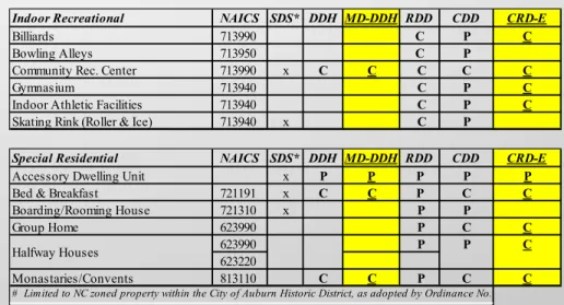
Indoor Recreational NAICS SDS* DDH MD-DDH RDD CDD CRD-E
Billiards 713990 C P C
Bowling Alleys 713950 C P
Community Rec. Center 713990 x C C C C C
Gymnasium 713940 C P C
Indoor Athletic Facilities 713940 C P C
Skating Rink (Roller & Ice) 713940 x C P
Special Residential NAICS SDS* DDH MD-DDH RDD CDD CRD-E
Accessory Dwelling Unit x P P P P P
Bed & Breakfast 721191 x C C P C C
Boarding/Rooming House 721310 x P P Group Home 623990 P C C 623990 P C 623220 Monastaries/Convents 813110 C C P C C Halfway Houses
# Limited to NC zoned property within the City of Auburn Historic District, as adopted by Ordinance No. 2
P
Arfcle IV: General Regulafons
Table 4-1 Table of PermiRed Uses
Commercial and Entertainment NAICS SDS* DDH MD-DDH RDD CDD CRD-E
Auto accessory store 441310 x C P
Banks 5221 C P C
Barbershop/beauty shop 812111 C P P
Book, Hobby, Music, & Sporting
Goods Stores 451 C P C
Brewpub 312120 x C C C
Building material sales (no outdoor
display) 444190 x C P C
Check Cashing C C C
Clothing Stores 448 C P C
Commercial or trade school 611511 x C P C
Copy shop 561439 C P C Dry Cleaners 812320 P P C Electronics Repair 8112 C P P Florists 4531 C P P Funeral Homes 812210 x C C C Garden Supply 44422 C P C
General Merchandise Stores 452 C P C
Grocery Stores 4451 C P C
Hardware Stores 444130 C P C
Health & Person Care Stores 446 C P P
Lounge C C C
Hotel/motel/condotel 721110 x C C C
Office Supplies, Stationery, Gift 4532 C P P
Pawn Shop C C C
Package store 445310 C P C
Pet/Pet Supply Store 45391 C P C
Precious Metal Purchase/Sales C C C
Private club 813410 x C C C
Professional Studios P P P
Restaurant C P P
Specialty Food Stores 4452 C P P
Theaters/Indoor Auditoriums 512131 C P C
Title Pawn C C C
Veterinary office/kennel 541940 x P P C
All others C C C
Road Service NAICS SDS* DDH MD-DDH RDD CDD CRD-E
ATMs x C P P
44111 C
44122
Auto repair, paint/body work 8111 x C C
Bank w/Drive Thru C C C
Buildling Material Sales (outdoor
display) 444190 x
C P
Car Wash/Detailing shop 811192 x C C
Convenience Stores/Small Grocery
(less than 3,000 sq. ft. - no fuel) 445120 C P C
Fast Food Restaurant 722211 x C C
531190 C
531120
Mobile Vendor Food Court x C C C
Gasoline/service station 447190 x C C
Parking Garages/ Lots 812930 x C C C
Small engine repair/ Sales 811411 x C C
All Other Uses C C C
Auto dealership x C
C
Flea market x
Commercial Recreational Use NAICS SDS* DDH MD-DDH RDD CDD CRD-E
Amphitheater x C C
Amusement park 713110 x C
Fairground 711310 x C
Miniature golf/driving range 713990 x C C
Race track 711212 x C
Stadium/arena 711310 x C
Recreational Rental Dwellings NAICS SDS* DDH MD-DDH RDD CDD CRD-E
Municipal Office/Facility 721211 P
Cottages/cabins 721199 P
Arfcle IV: General Regulafons
Table 4-1 Table of PermiRed Uses
^Only if mounted on an exis.ng structure
Public Service NAICS SDS* DDH MD-DDH RDD CDD CRD-E
Communications tower 237130 x C C^ C P C^
Hospital 622 x C C
Municipal Office/Facility C C C P P
Public utility station or facility C C C C C
Utility service yard or garage C C
All other Public Uses C C C C C
Agricultural Support NAICS SDS* DDH MD-DDH RDD CDD CRD-E
Farm equipment sales/rental/leasing 532490 x C
Farm equipment sales/repair 811310 x C
Farm produce sales (permanent) 445230 x C
Farm produce supply P
Farm product processing x C
Nurseries NAICS SDS* DDH MD-DDH RDD CDD CRD-E
Retail 444220 x C P
Wholesale 444220 P
Commercial Support NAICS SDS* DDH MD-DDH RDD CDD CRD-E
333993 C
333294
Contractor storage yard x C C
Mini-warehouse 531130 x C
Printing/publishing 323 x C C
Recycled materials collection/storage 562111 x C C Sales/repair of heavy equipment 811310 x C Vet. office/kennel w/outdoor pens 812910
Warehouse 236220 x C C
Wholesale distributor x C C
All others C C
x
Bottling plant/bakery C
Neighborhood Shopping Center NAICS SDS* DDH MD-DDH RDD CDD CRD-E
Neighborhood Shopping Center x P
Community Shopping Center NAICS SDS* DDH MD-DDH RDD CDD CRD-E Community Shopping Center 100,000
- 499,999 s.f. floor area x P
Regional Shopping Center NAICS SDS* DDH MD-DDH RDD CDD CRD-E
Shopping Ctr. 500,000+ s.f. floor area P
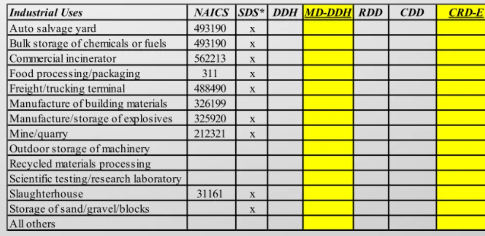
Industrial Uses NAICS SDS* DDH MD-DDH RDD CDD CRD-E
Auto salvage yard 493190 x Bulk storage of chemicals or fuels 493190 x Commercial incinerator 562213 x Food processing/packaging 311 x Freight/trucking terminal 488490 x Manufacture of building materials 326199 Manufacture/storage of explosives 325920 x Mine/quarry 212321 x Outdoor storage of machinery
Recycled materials processing Scientific testing/research laboratory
Slaughterhouse 31161 x Storage of sand/gravel/blocks x All others
Arfcle IV: General Regulafons
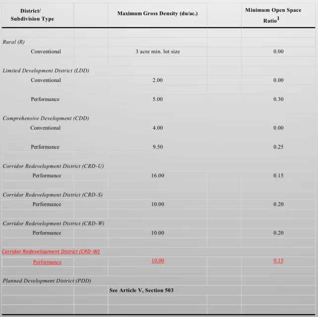
Table 4-2 Performance Standards for Residen.al Uses by District
District/ Subdivision Type
Maximum Gross Density (du/ac.)
Minimum Open Space Ratio1 Urban Core (UC)
Performance See Article V, Sections 502.02 and 506.03
Urban Neighborhood Districts (UN-E), (UN-W), & (UN-S)
Conventional 4.00 0.00
Performance See Article V, Sections 502.02., 506.04., and 509.
Neighborhood Conservation (NC)
See Article V, Table 5-2 Development District Housing (DD-H)
Conventional 4.00 0.00
Performance 5.50 0.30
Medium Density Development District - Housing
Performance 12.00 0.15
Neighborhood Redevelopment District (NRD)
Conventional 5.50 0.00
Performance 8.00 0.20
Redevelopment District (RDD)
Conventional 5.00 0.00
Arfcle IV: General Regulafons
Table 4-2 Performance Standards for Residen.al Uses by District
District/ Subdivision Type
Maximum Gross Density (du/ac.) Minimum Open Space Ratio1
Rural (R)
Conventional 3 acre min. lot size 0.00
Limited Development District (LDD)
Conventional 2.00 0.00
Performance 5.00 0.30
Comprehensive Development (CDD)
Conventional 4.00 0.00
Performance 9.50 0.25
Corridor Redevelopment District (CRD-U)
Performance 16.00 0.15
Corridor Redevelopment District (CRD-S)
Performance 10.00 0.20
Corridor Redevelopment District (CRD-W)
Performance 10.00 0.20
Corridor Redevelopment District (CRD-W)
Performance 10.00 0.15
Planned Development District (PDD)
See Article V, Section 503
1No open space shall be required in a performance residential development consisting of 4 dwelling units or less on an existing lot of record. No open space shall be required for town houses constructed in the Urban Core (UC) and all Urban Neighborhood (UN-E) (UN-W) & (UN-S), and Corridor Redevelopment Districts (CRD-U) and (CRD-E), and east of North Donahue Drive in the Corridor Redevelopment District – West (CRD-W) districts.
District Maximum FAR Maximum ISR Minimum site area3 Minimum lot width5 Angle of light factor Uses
Development District Housing (DD-H)
Agricultural Uses (Forestry) 0.01 0.10 25 acres None 1.0
Outdoor Recreational 0.05 0.40 7,500 SF 75 g. 1.0
Institutional 0.50 0.60 7,500 SF 75 g. 1.0
Indoor Recreational 0.50 0.60 7,500 SF 75 g. 1.0
Public Service2 0.20 0.50 7,500 SF 75 g. 1.0
All Other Uses 0.40 0.80 7,500 SF 75 g. 1.0
Medium Density Development District Housing (MD-DDH)
Outdoor Rec. (private parks) 0.05 0.40 7,500 SF none ***
Institutional 0.60 0.70 7,500 SF 60 ft. ***
Public Service 0.30 0.60 7,500 SF 60 ft. ***
All Others 0.70 0.80 7,500 SF 60 ft. ***
Arfcle IV: General Regulafons
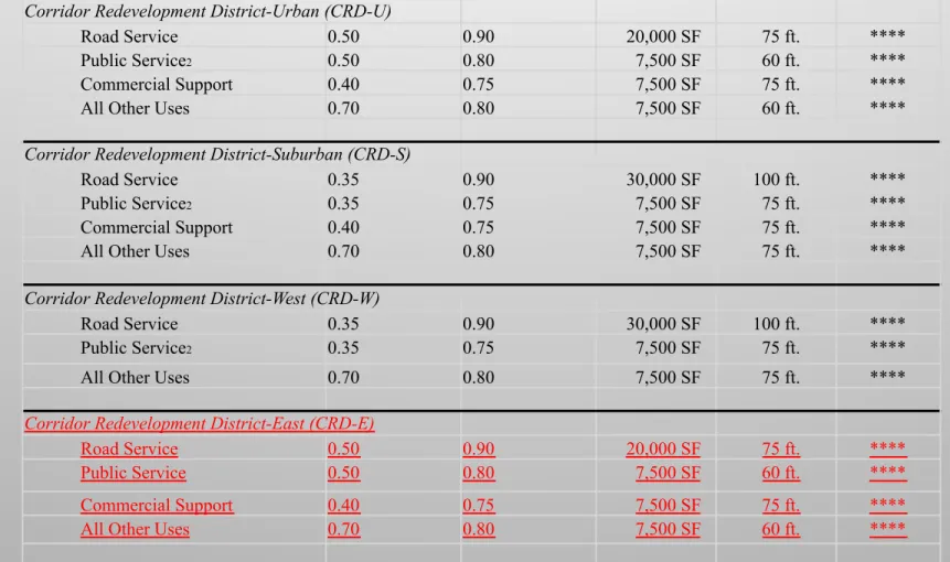
Corridor Redevelopment District-Urban (CRD-U)
Road Service 0.50 0.90 20,000 SF 75 ft. ****
Public Service2 0.50 0.80 7,500 SF 60 ft. ****
Commercial Support 0.40 0.75 7,500 SF 75 ft. ****
All Other Uses 0.70 0.80 7,500 SF 60 ft. ****
Corridor Redevelopment District-Suburban (CRD-S)
Road Service 0.35 0.90 30,000 SF 100 ft. ****
Public Service2 0.35 0.75 7,500 SF 75 ft. ****
Commercial Support 0.40 0.75 7,500 SF 75 ft. ****
All Other Uses 0.70 0.80 7,500 SF 75 ft. ****
Corridor Redevelopment District-West (CRD-W)
Road Service 0.35 0.90 30,000 SF 100 ft. ****
Public Service2 0.35 0.75 7,500 SF 75 ft. ****
All Other Uses 0.70 0.80 7,500 SF 75 ft. ****
Corridor Redevelopment District-East (CRD-E)
Road Service 0.50 0.90 20,000 SF 75 ft. ****
Public Service 0.50 0.80 7,500 SF 60 ft. ****
Commercial Support 0.40 0.75 7,500 SF 75 ft. ****
All Other Uses 0.70 0.80 7,500 SF 60 ft. ****
Arfcle IV: General Regulafons
Arfcle V: Detailed Use Regulafons
Secfon 504 Planned Developments.
A planned development is intended to encourage flexibility in si.ng, mixtures of housing types and land uses,
open space, and the preserva.on of significant natural features. The goal is a development in which buildings,
land use, transporta.on facili.es, u.lity systems and open spaces are integrated through an overall design. A
planned development shall be permiRed in a Planned Development District (PDD) overlay district. The PDD
overlay district is an addi.onal zoning requirement that is placed on a geographic area already zoned. The PDD
designa.on can be requested and considered only for proper.es already zoned as DDH,
MD-DDH,
CDD, LDD,
NRD,
RDD, CRD, and SCCD.
Secfon 505. Master Development Plan.
A Master Development Plan is a conceptual drawing that provides for the coordinated development of a
specific area. A Master Development Plan shall be required if one or more of the following is proposed:
E.
For any development site comprising five acres or more in the Urban Neighborhood (UN),
Neighborhood Redevelopment District (NRD), and Corridor Redevelopment (CRD) districts.
Arfcle V: Detailed Use Regulafons
505.06. Density and Open Space Standards for Individual Stages.
A Master Development Plan shall be
reviewed and approved by the Planning Commission prior to or simultaneously with any regular site plan or
subdivision plat submiRed. Upon approval of the Master Development Plan, the developer may submit and the
Planning Commission may approve subdivision plats or site plans for individual phases or stages.
Where any development site is to be developed in stages, no plat or phase plan for any frac.on of the site shall
be accepted for review which has more than the maximum gross density or less than the minimum required
open space as shown in this sec.on.
No individual stage shall exceed the following density or fail to meet the minimum open space percentage:
*Refer to Tables 4-1, 5-1, 5-2 and Section 502.02 for density requirements for other zoning districts not listed
Zoning District
Maximum
Density*
(Units/Acre)
Minimum
Open Space
(Percent)
CDD
14
15
LDD
7.5
20
DDH
8
15
MD-DDH
16
10
NRD
12
15
RDD
24
10
CRD-U
20
10
CRD-S
14
15
CRD-W
14
10
CRD-E
16
10
Arfcle V: Detailed Use Regulafons
Developme nt and design standard re quireme nts within the Corridor Re developme nt District (CRD-U, CRD-S, CRD-W, CRD-E)
Density
See Table 4-2: Performance Standards for Residential Uses by District
Height
Building height shall not exceed 35 feet.
Maximum building height for a mixed-use with upper floor residential in the CRD-U west of Ross Street along the frontage of Opelika Road and Gay Street and in the CRD-W along the frontage of Bragg Avenue may be 45 feet.
Setbacks
Non-residential Uses, Mixed-use, Cottage Housing Development (condominium ownership), and Multiple Unit Development
CRD-U and CRD-E
Front: 5 feet
Minimum Side: 10 feet1 Total Side: 20 feet1 Side Yard On Street: 10 feet
Rear: 15 feet
CRD-S and CRD-W
Front: 20 feet Minimum Side: 10 feet1 Total Side: 20 feet Side Yard On Street: 15 feet
Rear: 20 feet
1
CORRIDOR REDEVELOPMENT DISTRICT: Where a fireproof party wall is used, no side yard is required. Otherwise, the sidewall of the principal structure shall be set back at least ten (10) feet from the side property line or 15 feet from any adjacent building, whichever is greater.
See Section 502.02 for all other performance residential use standards.
510.02 Corridor Redevelopment District (CRD)
Development and Design Standards
Arfcle V: Detailed Use Regulafons
Mixed Use and Residential Use Provisions
CRD-U: only townhouses and multiple unit development may front Opelika Road. Other residential uses may front on side or back streets, or may be allowed on Opelika Road if setback a minimum of 100 feet and screened by a non-residential building.
CRD-S: no residential uses may front on Opelika Road. Residential uses may front on side of back streets.
In the CRD-U and CRD-S districts, residential uses are permitted on the first floor provided they are behind the façade of retail, office, commercial, or institutional uses.
CRD-W:
East of North Donahue Drive: only townhouses, cottage housing development, and multiple unit development may front Bragg Avenue and North Donahue Drive.
West of North Donahue Drive: all residential uses may front on North Donahue Drive and Martin Luther King Drive but must take access from side or back streets.
Floor to Area Ratio (FAR)
See Section 502.02 for performance residential use standards. See Table 4-3 for non-residential uses
Impervious Surface Ratio (ISR)
See Section 502.02 for performance residential use standards. For non-residential uses see Table 4-3
Open Space Requirements See Section 417 for all open space requirements.
Parking Requirement
See Section 502.02 for performance residential use standards. See Section 513 for parking requirement for non-residential uses
Cross Access
Cross access points should be provided connecting parking lots or other access ways. Cross access should be located at the rear of the property. If cross-access is provided from the adjoining property, the access shall be continued through the property. If a neighborhood or corridor plan for the area exists, cross access points should be provided where indicated in the plan if feasible. The Planning Director and City Engineer may grant relief from this requirement if topographical issues or structures prevent the connection from being made.
Arfcle V: Detailed Use Regulafons
Pedestrian connectivity
All developed sites shall provide at least one continuous, on-site intra- parcel pedestrian way of at least five feet (5'-0") in width to connect sidewalks adjoining rights-of-way to the main entrance(s) of that property's building(s), in compliance with the Americans with Disabilities Act (ADA). The Planning Director and City Engineer may grant relief from this requirement if topographical issues or structures prevent the connection from being made.
Parking Lot Screening
Parking for non-residential and mixed use developments must be located behind the front building facades.
Parking adjacent to any street ROW shall be screened with a Type 1, Option A fence (see Figure 4-2) with support piers that are clad with stone, brick, stucco or architecturally decorative concrete block and landscaped with 1 canopy tree and 6 shrubs for every twenty-five (25) feet of ROW frontage between the fence and street. The planting requirements and buffer width may vary due to site conditions at the discretion of the Planning Director.
It is also the desire of the Renew Opelika Road Corridor Plan and the Northwest Auburn Neighborhood Plan that residential use parking be located behind building facades. To achieve this, an increase in the impervious surface ratio (ISR), not to exceed 20% will be allowed.
Landscaping
Sites must meet the general landscaping requirements in Section 422 unless specifically excluded in this section.
Bufferyards
Street-trees – Where a street tree master plan has been implemented for a particular street which the development site fronts; the plantings from the street tree master plan will supersede the street frontage requirements for that particular frontage. If the Planning Director determines that the requirements of the street tree master plan cannot be met, the general landscaping requirements of Section 422 must be met.
Arfcle V: Detailed Use Regulafons
Landscaping (Continued)
Side and rear bufferyards may be reduced or waived by the Planning Director if the adjoining uses are similar in nature or if the buildings are built in a continuous urban form that would be interrupted by a greenspace.
Decks, porches, balconies and pedestrian areas, including plazas, street arcades, courtyards, and outdoor cafes may extend into bufferyards.
In no case shall the encroachment exceed 60 percent of the length of the property line of the particular bufferyard.
Building façade
The development shall have primary entrances that face and open directly on to publicly accessible streets or public open spaces. Buildings may have use an alternative entrance provided that there is outdoor dining or integrated display area between the building and public street.
If the building is located on a corner lot, the building may face the corner. Development Sites with multiple buildings must only have the façade of the principal building facing the primary street. Additional buildings may face internal drives or secondary streets.
Cladding Materials
Sites must meet requirements of Section 429 Corridor Overlay Standards. The Planning Commission may allow greater amounts of architectural metal provided it is approved by Planning Csommission. Corrugated metal or sheet metal may only be used as accent or to clad areas not visible from any designated corridor.
Concealed Equipment
The following shall be located or screened so as not to be visible from any public street: air conditioning compressors, window and wall air conditioners, dumpsters, electrical and other utility meters, irrigation and pool pumps, permanent barbeques, satellite antennae, utility appurtenances, mechanical rooftop equipment or ventilation apparatus.
Arfcle V: Detailed Use Regulafons
Signage
CRD-U, CRD-S, CRD-E and CRD-W west of North Donahue Drive: see Section 605, Permitted Signs
CRD-W:
East of North Donahue Drive:
Building signs and sandwich board signs as defined in Article VI are the only signs that are allowed in the CRD-W east of North Donahue Drive. Signs may be attached to any building façade. In a multi- tenant building, the building owner is responsible for distributing the sign allowance among the tenants.
Electronic reader boards are prohibited in the CRD-W district east of North Donahue Drive.
Single story building - Building facades that face a public street or that have the main entrance may have one (1) square foot of sign area for each (1) linear foot of building or space width, or sixteen (16) square feet, whichever is greater, but no more than fifty (50) square feet. Other building facades may have one-half (0.5) square foot of sign area for each (1) linear foot of building width, but no more than fifty (50) square feet.
Multi-story building - Building facades that face a public street or that have the main entrance may have two (2) square feet of sign area for each (1) linear foot of building or space width or thirty-two (32) square feet, whichever is greater, but no more than seventy five (75) square feet. Other building facades may have one-half (0.5) square foot of sign area for each (1) linear foot of building width, but no more than seventy-five (75) square feet.
Arfcle V: Detailed Use Regulafons
Signage (Continued)
Blade signs are encouraged and a blade sign not exceeding six (6) square feet can be provided in addition to building mounted signage on any façade that has a sidewalk or entrance. A blade mounted sign is defined as an ornamental rod extending perpendicular from the building with a hanging sign suspended from it at a 90-degree angle from building face and street ROW. Blade signs are to be placed a minimum of nine (9) feet above sidewalk level to the bottom of the blade sign. Text and graphics on either or both ends of an awning that are oriented perpendicular to the building face for pedestrian view and are no more than six (6) square feet may be provided in lieu of a blade sign.
All building signs must be mounted between the first and second floor line, or between the second and third floor line or near the top of the wall. The Planning Director, or appropriate designee, may approve an alternate location for a sign in cases where these locations conflict with or may cause damage to architectural ornamentation of a building. In any case, building signs may not be mounted higher than the building. Signage area for the primary sign is computed by measuring the number of square feet in the smallest rectangle, within all letters, logos, symbols or other elements of the sign can be enclosed.
A sandwich board sign is a sign of A-frame construction designed for placement on the sidewalk in front of the place of business being advertised, and is generally two (2) sided. Sandwich board signs that meet all of the following criteria may be placed and displayed on a public sidewalk:
a. A height of no more than four (4) feet;
b. Maximum area of any side is eight (8) square feet; c. No illumination;
d. Placed in front of the building or leased space during business hours respective to the use in the building or leased space;
Arfcle V: Detailed Use Regulafons
Signage (Continued)
e. Maintains a clearance on the sidewalk of at least five (5) feet; and, f. Maintains a distance of at least twenty (20) feet from any other sandwich board sign.
Where adjacent buildings are narrow and sign placements on either side make it impossible for a building owner or tenant to meet the sandwich board spacing requirement, the Planning Director, or appropriate designee, may approve an alternative location that maximizes distance between adjacent signs.
Awnings and Canopies
Sloped or flat awnings and canopies are allowed. Awnings fabricated of canvas or metal are allowed. Awnings may be placed above and extend the width of any door or window, or extend up to 75% of the width of the building façade along the street line, whichever is greater; and must be supported from the building façade with suspension rods.
Support structures for awnings or canopies cannot extend from the sidewalk.
Awnings slopes may be flat to 45 degrees maximum and may not exceed 5 feet in vertical height.