Version 4.5 (2011)
INTERMAGNET TECHNICAL REFERENCE MANUAL Version 4.5
2011
Edited by: Benoît St-Louis
This document has been prepared by the INTERMAGNET Operations Committee and Executive Council. Every effort has been made to ensure that the information is accurate and current. The document is distributed in the hope that it will be a useful reference not only for those participating formally in INTERMAGNET, but also for the greater geomagnetic community.
Acknowledgements
We gratefully acknowledge the many and significant contributions and comments provided by our colleagues.
This manual is based on the original document (INTERMAGNET Technical Reference Manual version 1.0 1994 )
Edited by: Douglas F. Trigg Richard L. Coles Prepared by: Diane Regimbald
The INTERMAGNET office: INTERMAGNET
c/o British Geological Survey Murchison House
West Mains Road Edinburgh EH9 3LA UK
TABLE OF CONTENTS
QUICK REFERENCES
' INTERMAGNET WEB SITES . . . v
' GIN INTERNET ADDRESSES . . . v
' DVD/CD-ROM DISTRIBUTION OFFICE . . . v
' GENERAL INQUIRIES . . . v
CHAPTER 1 INTERMAGNET 1.1 INTRODUCTION . . . 1
1.2 INTERMAGNET OBJECTIVE . . . 1
1.3 HISTORY AND STATUS OF INTERMAGNET . . . 1
1.4 THE INTERMAGNET PRINCIPLES AND CONDITIONS . . . 1
1.5 PARTICIPATION . . . 2
1.6 PRODUCTS . . . 2
1.7 CONDITIONS OF USE . . . 3
1.8 INTERMAGNET MANAGEMENT . . . 4
CHAPTER 2 INTERMAGNET MAGNETIC OBSERVATORIES - IMOs 2.1 SPECIFICATIONS . . . 5
2.2 DATA SAMPLING AND FILTERING . . . 5
2.3 DATA ENCODING FOR ELECTRONIC MAIL TRANSMISSION . . . 6
2.4 DATA ENCODING FOR SATELLITE TRANSMISSION . . . 6
2.5 DATA ENCODING FOR DVD/CD-ROM . . . 6
2.6 ABSOLUTE MEASUREMENTS / BASELINES . . . 6
CHAPTER 3 GEOMAGNETIC INFORMATION NODES - GINs 3.1 DEFINITION . . . 9
3.2 FUNCTIONS AND RESPONSIBILITIES . . . 9
3.3 DATA TRANSMISSION FORMATS . . . 10
3.4 USER ACCESS TO GINs . . . 10
3.5 GIN MANAGER ADDRESSES . . . 11
3.6 GIN INTERNET ADDRESSES . . . 11
CHAPTER 4 THE INTERMAGNET DVD/CD-ROM 4.1 INTRODUCTION . . . 13
4.2 GENERAL FEATURES . . . 13
4.3 IAF INTERMAGNET ARCHIVE FORMAT (DVD/CD-ROM) . . . 13
4.3.1 IAFV2.10 (2010 and after) . . . 13
4.3.2 IAFV2.00 (2009) . . . 14
4.3.3 IAFV1.10 (2008) . . . 15
4.3.4 IAFV1.00 (2007 and before) . . . 15
4.4 STORAGE REQUIREMENTS . . . 16
4.5 INTERMAGNET DVD/CD-ROM DIRECTORY STRUCTURE . . . 16
4.6 INTERMAGNET CD-ROM SOFTWARE . . . 17
CHAPTER 5 SATELLITES 5.1 GEOSTATIONARY SATELLITES . . . 19 5.2 METEOSAT . . . 19 5.3 GOES . . . 19 5.4 TRANSMISSION ACCESS . . . 19 5.5 SATELLITE OPERATORS . . . 20 5.6 SATELLITE SERVICES . . . 21
CHAPTER 6 DATA QUALITY CONTROL
6.1 INTRODUCTION . . . 23
6.2 THE OBSERVATORY MEASUREMENT PROCESS . . . 23
6.3 COMPUTATION OF BASELINE VALUES . . . 24
6.4 BASELINE ADOPTION . . . 25
6.5 THE COMPUTATION OF TOTAL FIELD DIFFERENCES . . . 25
6.6 SUMMARY . . . 26
CHAPTER 7 WORLD WIDE WEB 7.1 INTRODUCTION . . . 27
7.2 WEB SITE ADDRESS . . . 27
APPENDIX A-1 INTERMAGNET TERMINOLOGY . . . 29
APPENDIX B-1 OBSERVATORIES PARTICIPATING IN INTERMAGNET . . . 31
APPENDIX B-2 PICTORIAL MAP - SATELLITE FOOTPRINTS AND IMOs OPERATING IN 2011 . . . 35
APPENDIX C-1 IAFV2.10 INTERMAGNET ARCHIVE FORMAT . . . 37
IAFV2.00 INTERMAGNET ARCHIVE FORMAT . . . 38
IAFV1.10 INTERMAGNET ARCHIVE FORMAT . . . 39
IAFV1.00 INTERMAGNET ARCHIVE FORMAT . . . 40
APPENDIX C-2 INTERMAGNET DVD/CD-ROM DIRECTORY STRUCTURE . . . 41
APPENDIX C-3 IYFV1.02 INTERMAGNET DVD/CD-ROM FORMAT FOR YEARMEAN FILE . . . 43
APPENDIX D-1 INTERMAGNET EXECUTIVE COUNCIL ADDRESSES . . . 47
INTERMAGNET OPERATIONS COMMITTEE ADDRESSES . . . 48
APPENDIX E-1 INTERMAGNET FORMAT IMFV2.83 . . . 51
APPENDIX E-2 SATELLITE CODING EXAMPLES . . . 57
APPENDIX E-3 IMFV1.23 INTERMAGNET GIN DISSEMINATION FORMAT FOR MINUTE VALUES . . . 63
IMFV1.22 INTERMAGNET GIN DISSEMINATION FORMAT FOR MINUTE VALUES . . . 65
APPENDIX E-4 IBFV2.00 INTERMAGNET BASELINE FORMAT (2009 and AFTER) . . . 67
IBFV1.20 INTERMAGNET BASELINE FORMAT (2008 and BEFORE) . . . 69
APPENDIX E-5 IAGA2002 INTERMAGNET EXCHANGE FORMAT (Spreadsheet compatible) . . . 71
APPENDIX F-1
FILTER COEFFICIENTS TO PRODUCE ONE MINUTE VALUES . . . 77
APPENDIX G-1 INTERMAGNET MEMBERSHIP APPLICATION . . . 79
INTERMAGNET MEMBERSHIP APPLICATION FORM . . . 81
INTERMAGNET INSTRUMENT SPECIFICATION FORM . . . 83
A. CONTINUOUSLY RECORDING VECTOR MAGNETOMETER . . . 83
B. CONTINUOUSLY RECORDING SCALAR MAGNETOMETER . . . 83
C. DATA ACQUISITION SYSTEM . . . 83
D. DATA TRANSMISSION . . . 84
E. OBSERVATORY BASELINE INFORMATION . . . 84
QUICK REFERENCES
' ' '
' INTERMAGNET WEB SITES
www.intermagnet.org obsmag.ipgp.jussieu.fr/intermagnet kogma.nict.go.jp/intermagnet/ swdcwww.kugi.kyoto-u.ac.jp/intermagnet www.Intermagnet.bgs.ac.uk intermagnetusa.org ' ' '
' GIN INTERNET ADDRESSES
[email protected] [email protected] [email protected] [email protected] [email protected] [email protected] ' ' '
' DVD/CD-ROM DISTRIBUTION OFFICE
INTERMAGNET DVD/CD-ROM distribution office Observatoire Magnétique National
Carrefour des 8 routes F-45340 Chambon la Forêt FRANCE Tel: 33 (0) 2-38-33-95-00 Fax: 33 (0) 2-38-33-95-04 Internet: [email protected] ' ' ' ' GENERAL INQUIRIES Duff C. Stewart
INTERMAGNET Operations Committee c/o U.S. Geological Survey
Box 25046 MS 966 Denver Federal Center Denver, Colorado 80225-0046 USA
TEL: 44-131-667-1000 FAX: 44-131-667-1877
CHAPTER 1 INTERMAGNET
1.1 INTRODUCTION
This manual describes the global near-real-time magnetic observatory network, known as INTERMAGNET. Throughout the document, the term "magnetic observatory" will mean a recording station where absolute measurements of the geomagnetic field are made on a regular basis over many years and which produces data of the requisite quality for secular variation studies. The term "near real-time" in this context means that data are supplied for distribution within 72 hours of acquisition.
The automation of magnetic observatories in several countries, operated remotely by means of telephone communications, has demonstrated that data on the dynamic magnetic field of the Earth can be collected quickly using modern data capture techniques and communications systems. It is logical to coordinate national activities and to extend the use of such techniques worldwide. It is now possible to adopt a new standard for geomagnetic measuring and monitoring equipment and to transfer data rapidly to regional Geomagnetic Information Nodes (GINs) using satellite and network communications. These geomagnetic information nodes collect data from their sector of the globe for dissemination to the user communities in a timely manner. GINs can, when needed, exchange data and may also disseminate products such as geomagnetic indices and activity models.
A successful pilot scheme operated during 1989, including the UK, USA, and Canada transmitting and receiving at 12 minute or 1 hour intervals geomagnetic data recorded every minute. As a result of the pilot scheme, the IAGA Executive Committee endorsed INTERMAGNET. The SEDI (Study of the Earth's Deep Interior) Steering Committee has also endorsed INTERMAGNET.
1.2 INTERMAGNET OBJECTIVE
The INTERMAGNET objective is to establish a global network of cooperating digital magnetic observatories, adopting modern standard specifications for measuring and recording equipment, in order to facilitate data exchange and the production of geomagnetic products in close to real time.
1.3 HISTORY AND STATUS OF
INTERMAGNET
The possibility of worldwide data communication between magnetic observatories was first raised seriously at the Workshop on Magnetic Observatory Instruments, held in Ottawa, Canada, in August 1986. Further discussions, particularly between the British Geological Survey (BGS) and the US Geological Survey (USGS) took place in May 1987 at the Nordic Comparison Meeting held at Chambon la Forêt, France. A pilot scheme between BGS and USGS was described at the sessions of Division V of IAGA during the XIXth General Assembly of IUGG in Vancouver, Canada, in August 1987, with the proposal that the geomagnetic community should adopt automatic observatories with satellite communications as its mode of operation for the future. INTERMAGNET embodies the proposal to extend worldwide the network of observatories communicating in this way.
At present the observatories shown in Appendix B-1 are transmitting through satellites, or daily by computer link, to GINs. More stations are coming online rapidly. GINs are now operating in Edinburgh (BGS), Golden (USGS), Hiraiso (NICT), Kyoto (Kyoto U.), Ottawa (GSC), and Paris (IPGP).
1.4 THE INTERMAGNET PRINCIPLES AND CONDITIONS
INTERMAGNET is operated according to principles and conditions which are accepted as necessary and desirable for maintaining a service of rapid magnetic observatory data exchanges for the international scientific community and for commercial users. 1. INTERMAGNET is a non-exclusive program of
worldwide data exchange between magnetic observatories.
2. An INTERMAGNET aim is the establishment and maintenance of observatories in remote areas where local support is lacking.
3. INTERMAGNET encourages the establishment and maintenance of digital observatories in developing countries, with the involvement and enhancement of local science and technology.
4. Each participating country/institution is expected to bear the costs of its participation in INTERMAGNET.
5. Data will be transmitted from observatories or operating institutes to regional geomagnetic information nodes (GINs) by satellites, computer networks or by other near real-time means, using standard INTERMAGNET formats.
6. Regional geomagnetic information nodes will exchange data and data products globally as rapidly as appropriate, and will maintain data files for all contributing observatories for a period commensurate with the immediate usefulness of the product. 7. The collected data will be made available to the
scientific community and to participating observatories on media and in formats approved by the INTERMAGNET Executive Council.
8. All data are supplied on the condition that they are not used for commercial gain (media, transcription and other costs may be charged to the user). 9. The INTERMAGNET Executive Council recognizes
the value to commerce of geomagnetic data and derived products which are available in near real time, and accepts the right of participating institutions to recover costs for services and to levy charges where possible and as necessary. Participating institutions will undertake to safeguard the interests of fellow participants, concerning the commercial usage of their data.
10.Each INTERMAGNET GIN will provide annually to each participating institution or observatory a statement of data received by the GIN and of its data supplied by the GIN to users.
11.Participating institutes will co-operate to facilitate the production of globally representative data products, such as the official IAGA indices.
12.Participating institutions will agree to submit definitive data annually for inclusion on an INTERMAGNET DVD and will receive in return one copy of the DVD free of charge.
1.5 PARTICIPATION
INTERMAGNET membership is available to institutions who wish to operate one or more INTERMAGNET Magnetic Observatories (IMOs). Members agree to allow distribution of their IMO data in accordance with INTERMAGNET guidelines. In return for participation, Institutional membership provides: access to near real-time data from any IMOs for all members of the Institution; access to the best in magnetic observatory technologies and assistance in implementing them and possibilities of discounts on satellite communications. There are, at present, no membership fees. An application to become a member is submitted to the INTERMAGNET office for approval by the Executive Council, subject to technical evaluation by the Operations Committee. The membership application form is included in Appendix G-1.
Individual researchers may also be granted access to IMO data distributed through GINs. They must apply to an INTERMAGNET GIN and agree to abide by all INTERMAGNET guidelines. They will then be put in contact with the most convenient GIN. Charges for access to data may apply.
1.6 PRODUCTS
Minute values of geomagnetic components along with other INTERMAGNET products may be retrieved from the web site (http://www.intermagnet.org) under Data. Minute values are kept on-line permanently to allow comparisons between preliminary and definitive data and to give data sets that can be used to test software that works with preliminary data. When available, definitive data should preferably be used. A DVD (CD-ROM before 2006) containing definitive data from INTERMAGNET observatories is created annually. The INTERMAGNET DVDs/CD-ROMs are available at no charge to participating institutes and to bona fide scientists for academic purposes only. Technical help for operators of IMOs may also be available by special arrangements through the INTERMAGNET office.
1.7 CONDITIONS OF USE
The Geomagnetic data available through INTERMAGNET are provided for your use (and for the use of colleagues collaborating on the same project) and are not for sale or distribution by you to third parties, without the express written permission of the Institute that operates the observatory. Any report or publication that makes use of these data should acknowledge that Institute as the source. One copy of each report or publication should be sent to the Institute.
We ask that the data not be used for commercial purposes, nor in any project in which you, your organization, or your collaborators are in a commercial agreement with any third party.
Your e-mail address, which you provide to INTERMAGNET when requesting data, will be given to the Institute supplying the data so that it may monitor the use of its data.
By accessing these data you signify your acceptance of these terms and conditions. For commercial applications of observatory data, please contact the operating Institute directly.
INTERMAGNET accepts no liability in respect of loss, damage, injury or other occurrence arising from the provision of these data.
1.8 INTERMAGNET MANAGEMENT
The Executive Council establishes policy for INTERMAGNET, deals with questions of international participation and data exchange, and communicates with national agencies and international scientific and funding agencies.
Executive Council membership: J.J. Love (USA) (Chairman) D. Boteler (Canada)
A. Chulliat (France) D.J. Kerridge (UK)
The Operations Committee advises the Executive Council on matters relating to magnetic sensors, data capture and data processing, and on communications options, protocols, etc. The Operations Committee is also responsible for establishing and maintaining standards of operation and uniform data formats and transmission characteristics which optimize global exchange.
Operations Committee membership: P. Crosthwaithe (Australia) L. Decker (France)
S.M. Flower (United Kingdom) H-J. Linthe (Germany) J. Matzka (Denmark) M. Nose (Japan)
J. Rasson (Belgium) (Chairman) J. Reda (Poland)
B.J. St-Louis (Canada) D.C. Stewart (USA)
CHAPTER 2 INTERMAGNET MAGNETIC OBSERVATORIES - IMOs
2.1 SPECIFICATIONS
An INTERMAGNET Magnetic Observatory (IMO) is a magnetic observatory, having full absolute control, that provides one minute magnetic field values measured by a vector magnetometer, and an optional scalar magnetometer, all with a resolution of 0.1 nT. Vector measurements performed by a magnetometer must include the best available baseline reference measurement.
An IMO must try to meet the following recommendations:
Definitive Data
Accuracy: ±5 nT
Absolute Measurements (See Section 2.6)
Vector Magnetometer
Resolution: 0.1 nT
Dynamic Range: 8000 nT High Latitude
6000 nT Mid/Equatorial Latitude Band pass: D.C. to 0.1 Hz
Sampling rate: 1 Hz Thermal stability: 0.25 nT/EC Long term stability: 5 nT/year
Scalar Magnetometer
Resolution: 0.1 nT Accuracy: 1 nT
Sampling rate: 0.033 Hz (30 sec)
Clock Timekeeping
Observatory data logger: 5 seconds/month Data collection platform: ± 1.5 sec GOES, GMS
± 1.0 sec METEOSAT
Recorder
An on-site recorder is necessary so data are not lost as a result of satellite transmission outages.
Transmission
Transmission must be by satellite or other electronic means, within 72 hours of acquisition, to a Geomagnetic Information Node (GIN).
Note: Keeping within the time slot for satellite transmission is an important duty of an IMO operator. When advised by a GIN of a time drift, the IMO operator must make the necessary corrections within 24 hours.
Other
Data format: IAGA2002 or IMFV2.83 or IMFV1.23 (or later)
Definitive data: to be submitted for inclusion on the DVD/CD-ROM
Baseline data: each component to be submitted for inclusion on the DVD/CD-ROM
Filtering: to INTERMAGNET standard (Section 2.2)
Proton Gyromagnetic Ratio
In 2009, INTERMAGNET adopted the new proton gyromagnetic ratio published by the CODATA group in 2006: gp = 2.675153362*108 T-1s-11
2.2 DATA SAMPLING AND FILTERING
In its Resolution 12 from the 1979 Assembly in Canberra, IAGA noted the desirability of digital magnetic observatories using a sampling rate no slower than once every 10 seconds. In that resolution, IAGA also stated that the one-minute means should be centered on the minute.
To minimize aliasing of higher frequency signals into the pass-band of the final minute data series, anti-aliasing filters should be included in the analogue portions of magnetometers before analogue-to-digital conversion. The filter responses should be matched to the chosen primary digital sampling rate. Subsequent to the digital sampling, INTERMAGNET requires that a numerical filter be applied in order to obtain the final minute data series.
One digital filter that is widely used by INTERMAGNET can be achieved by applying the following coefficients (for a Gaussian filter) to a series of 19 samples of 5-second data:
C0 = 0.00229315 C10 = 0.11972085 C1 = 0.00531440 C11 = 0.10321785 C2 = 0.01115655 C12 = 0.08061140 C3 = 0.02121585 C13 = 0.05702885 C4 = 0.03654680 C14 = 0.03654680 C5 = 0.05702885 C15 = 0.02121585 C6 = 0.08061140 C16 = 0.01115655 C7 = 0.10321785 C17 = 0.00531440 C8 = 0.11972085 C18 = 0.00229315 C9 = 0.12578865
For a filter output value to be centered on the minute, coefficient C0 is applied 45 seconds before this minute and coefficient C18 is applied 45 seconds after the minute.
In addition to the attenuation provided by the numerical filter, a “natural filter” applies, estimated at -9 to -18 dB/Octave typically, caused by the decrease in energy of the natural field with increasing frequency.
Examples of other acceptable sets of filter coefficients, for use with various sampling rates of properly anti-aliased signals are presented in Appendix F-1.
A scalar magnetometer must provide a sample centered on the same time as the output of the digital filter used with the vector magnetometer.
When mean values are to be calculated the question of how to handle missing data arises. For a number of reasons it is difficult to devise a simple objective rule that can be applied to all cases. INTERMAGNET recommends a simple and pragmatic approach; mean values may be calculated when 90% or more of the values required for calculation of the mean are available. When fewer than 90% of the required values are available the mean value should be assigned the value used to flag missing data. INTERMAGNET recommends adoption of this rule for both simple mean and weighted mean calculations. For example, a simple hourly mean value may be computed when 54 or more one-minute values are available for the hour. Similarly, if a one-minute value is constructed from one-second samples, the one-minute value may be computed when 54 or more one-second samples are available. In this case the weights (filter coefficients) assigned to the samples must be re-normalized (the sum of the weights applied to the samples used to calculate the mean value must be unity). INTERMAGNET observatories are expected to provide high levels of data continuity, so this rule is expected to be applied only rarely.
2.3 DATA ENCODING FOR ELECTRONIC MAIL TRANSMISSION
Electronic mail transmission of data to a GIN must be done using IAGA 2002 Format or INTERMAGNET GIN Dissemination Format for Minute Values IMFV1.23 described in Appendix E-3. When an IAGA 2002 file is sent, the SUBJECT field should contain the correctly formatted IAGA 2002 file name. When using the IMFV1.23 Format, the SUBJECT field of the electronic mail header should contain the filename being sent as defined in IMFV1.23.
for example:
Subject:MAR1592.BOU
This indicates that a day file containing data from Boulder observatory March 15 is sent. A complete day's data is assembled into each IMFV1.23 file.
A list of GIN Internet addresses can be found in the Quick References section.
2.4 DATA ENCODING FOR SATELLITE TRANSMISSION
In preparation for transmitting data to one of several possible satellites an IMO will first prepare its data in INTERMAGNET format IMFV2.83 or later, which is fully described in Appendix E-1. This format imposes a common structure on the data files, ensuring that all necessary information is included so that the data may be properly decoded at a GIN. Once data are in IMFV2.83, a supplementary encoding step is applied to make the data stream, as transmitted to satellites, exactly compatible with the requirements of the satellite operators. Appendix E-2 shows the supplementary encoding steps for the GOES and Meteosat satellites along with examples using a specific data set. Appendix E-2 also provides provisional information about encoding for the GMS satellite.
2.5 DATA ENCODING FOR DVD/CD-ROM
Definitive data for an IMO are to be provided to INTERMAGNET shortly after the end of each calendar year (six months maximum) for inclusion in an annual INTERMAGNET DVD. The format for submission of data appears in Appendix C-1. Baseline data will accompany the definitive data, and will be provided in format IBFV2.00 or later as described in Appendix E-4. Refer to chapter 4 for a general description of the DVD/CD-ROM.
2.6 ABSOLUTE MEASUREMENTS / BASELINES
The provision of absolute control at a magnetic observatory requires a series of measurements of the absolute values of the geomagnetic field using manually operated instruments. Ideally, the frequency at which these measurements are made may vary from daily to weekly, depending on the variometer characteristics, the stability of the piers and installation and logistical considerations. The quality of the absolute control may be judged by examining the baseline corrections to the variometer data (see Appendix E-4). Some IMOs may use intermediate Reference Measurements (RM) which are more stable for inter-comparison. Chapter 6
provides a discussion of data quality control.
Several combinations of instrumentation are in use for absolute determinations, but INTERMAGNET recommends a proton precession magnetometer and a Declination/Inclination magnetometer (fluxgate mounted on a theodolite). Many factors are involved in achieving good baselines at a magnetic observatory. Some suggestions are presented in this short summary. A good adopted baseline shows a low scatter of individual baseline determinations, and has few drifts or offsets. Executive Council and Operations Committee recommend to:
1. Make weekly absolute observations, avoiding intervals of magnetic disturbance. If the baseline is changing rapidly, increase the frequency of absolute observations.
2. Make regular physical inspections of all observatory buildings to ensure that no magnetic materials which would cause jumps in baselines have been lying around, inside or outside the building. 3. Ensure that absolute instruments and their
supporting piers are free from contaminating magnetic materials.
4. Set up a pier in an undisturbed area outside the absolute building; determine the absolute differences between the external pier and the main absolute pier at least once a year, to check for changes in the magnetic environment.
5. Maintain an up-to-date diary of absolute measurements, visits, repairs and other actions at the observatory.
6. Operate two variometers at the observatory and compare their data records.
7. Keep variometers, interconnecting cables, and control electronics at constant temperatures. 8. Continuously monitor and record the temperatures
of all sensors, cables, and electronics units. 9. Review the procedures in use for absolute
measurements at the observatory and consider if there are better procedures that could be use. INTERMAGNET recommends the use of a proton p r e c e s s i o n m a g n e t o m e t e r a n d a Declination/Inclination magnetometer (fluxgate mounted on a theodolite).
10. Undertake visits between institutions by observers
to encourage the exchange of ideas on instrumentation and observatory practice. Attend IAGA workshops.
11. Establish inter-observatory absolute instrument comparisons by observers, similar to the concept of the Scandinavian inter-observatory comparisons. Attend IAGA workshops.
12. Undertake better training of observers.
13. Provide meaningful information to observers about how their work contributes to local and worldwide research projects, and how baseline quality can affect the research.
This manual will not elaborate on the details of absolute techniques. However, useful articles can be found in Wienert (1970), Stuart (1984), Coles (1988), Kauristie et al. (1990), Rasson (1996), and Best and Linthe (1998). Two comprehensive manuals contain detailed sections on absolute measurement techniques. These are the "Guide for Magnetic Repeat Station Surveys" (Newitt, Barton, and Bitterly) and the "Guide for Magnetic Measurements and Observatory Practice" (Jankowski and Sucksdorff).
References:
Best, A. and Linthe, H.-J. (eds.) 1998. Proceedings of the VIIth Workshop on Geomagnetic Observatory Instruments, Data Acquisition and Processing, GeoForschungsZentrum Potsdam, Scientific Technical Report STR98/21, 450p.
Coles, R.L. (ed.) 1988. Proceedings of the International Workshop on Magnetic Observatory Instruments; Geological Survey of Canada Paper 88-17, 94 p. Jankowski, J. and Sucksdorff, C. 1996. Manual on Magnetic Measurements and Observatory Practice, International Association of Geomagnetism and Aeronomy, Boulder, Co., 235 p.
Kauristie, K., Sucksdorff, C., and Nevanlinna, H. (eds.) 1990. Proceedings of the International Workshop on Geomagnetic Observatory Data Acquisition and Processing; Finnish Meteorological Institute, Geophysical Publications No.15, 151 p.
Loubser, L. 2002. Proceedings of the Xth IAGA Workshop on Geomagnetic Instruments, Data Acquisition and Processing, 300 p.
Newitt, L.R., Barton, C.E., and Bitterly, J. 1996. Guide for Magnetic Repeat Station Surveys, International Association of Geomagnetism and Aeronomie, Boulder, Co., 112 p.
Prigancová, A., Vörös, Z., 2000. IXth IAGA Workshop on Geomagnetic Observatory Instruments, Data Acquisition and Processing, Contributions to Geophysics and Geodesy, Geophysical Institute Slovak Academy of Sciences Vol. 31, No. 1, 454 p.
Rasson, J.L. (ed.) 1996. Proceedings of the VIth Workshop on Geomagnetic Observatory Instruments, Data Acquisition and Processing, Dourbes, Institut Royal Meteorologique de Belgique, Publication scientifique et technique N. 003., 249 p.
Stuart, W.F.(ed.) 1984. Geomagnetic observatory and survey practice; reprinted from Geophysical Surveys, Vol. 6, nos. 3/4; D. Reidel, Dordrecht/Boston, 464 p. Wienert, K.A. 1970. Notes on geomagnetic observatory and survey practice; UNESCO, Paris, 217 p.
CHAPTER 3 GEOMAGNETIC INFORMATION NODES - GINs
3.1 DEFINITION
In order that all INTERMAGNET data transfers may be handled efficiently, INTERMAGNET has established a number of Geomagnetic Information Nodes (GINs). The function of the GINs is to collect magnetic observatory data in near-real time, store it in a database, and forward it to the INTERMAGNET data repository from which it may be easily obtained through the web site and its mirrors by users of INTERMAGNET data. The GIN manager functions as a point of contact for IMOs to resolve any data transmission and formatting problems.
Geomagnetic Information Nodes have been set up in the following locations:
Golden, Colorado - United States Geological Survey
Ottawa, Canada - Geological Survey of Canada
Edinburgh, Scotland - British Geological Survey Paris, France - Institut de Physique du
Globe de Paris Kyoto, Japan - Kyoto University
Hiraiso, Japan - National Institute of I n f o r m a t i o n a n d C o m m u n i c a t i o n s Technology
Full GIN addresses are given at the end of this chapter. All sites are either equipped with satellite receiving equipment or receive satellite data from a satellite collecting center. All sites also have computers supporting electronic mail. This allows easy input of data from any magnetic observatory participating in INTERMAGNET. Depending on GIN location and the method used to input data, either satellite or electronic mail, observatory data are available to users from a minimum time of 12 minutes to a maximum time of 72 hours after the observatory recordings are made. If the observatory is transmitting its data through the GOES satellite links, the data reach the GIN within 12 minutes of recording. An alternative method, for observatories not equipped with satellite transmission equipment, is to input data to a GIN using electronic mail (E-Mail). To use this method an observatory must relay its data at least once every 72 hours to a GIN.
3.2 FUNCTIONS AND RESPONSIBILITIES
When observatory data are relayed to a GIN the format of these data may be either IAGA 2002,
I N T E R M A G N E T F o r ma t I M F V 2 . 8 3 o r INTERMAGNET GIN Dissemination Format for Minute Values IMFV1.23, or subsequent versions. The IMFV2.83 format is used for data transmitted through a satellite link, the IAGA 2002 and IMFV1.23 format for data input via an E-Mail message.
Once the data have been received the first process carried out by the GIN is to convert the IMFV2.83 format data to IMF V1.23 format and to designate them as REPORTED data. The second process is to forward these data files onto the INTERMAGNET data repository.
Each GIN will, as a routine daily task, produce stackplots of data received from all input sources. These are used as a quality assurance guide on the operation of each contributing observatory. No attempt will be made at any GIN to modify any REPORTED data input to it, but a GIN may apply spike removal routines to REPORTED data to produce other files from which stackplots are produced.
IMFV1.23 data can exist in one of three forms: 1) REPORTED Data - Data as input from an observatory, transmitting through a satellite or using E-Mail. REPORTED data have not had any baseline corrections applied, they may contain spikes and may have missing values.
2) ADJUSTED Data - Each observatory or its parent institute is allowed to modify REPORTED data files to produce ADJUSTED data, with a goal of 7 days after transmission. These adjustments may be to modify baselines, remove spikes or fill gaps, etc. on any day file. When data are missing from an ADJUSTED data file, these data may be input to a GIN in a later message. This new message file can be transmitted to a GIN with the 'A' flag set in byte 25 of each hourly block header. ADJUSTED data are maintained online until the annual DVD is available. They are then archived by the GIN and are only available thereafter by special arrangement. 3) DEFINITIVE Data - This describes observatory data which have been corrected for baseline variations, have had spikes removed and gaps filled where possible. DEFINITIVE data have each block header byte 25 in format IMFV1.23 set to 'D', and the quality of the data is such that in this form they would be used for inclusion into Observatory Year Books, input to World Data Centers and included on the annual INTERMAGNET DVD.
3.3 DATA TRANSMISSION FORMATS
In order that all INTERMAGNET data relayed between GINs and participating institutes share common standards, a series of GIN data formats have been developed by the INTERMAGNET Operations Committee. All data transfers between GINs and IMOs are in these formats, and a GIN will not accept data from any INTERMAGNET participant unless they adhere strictly to the defined formats.
1) IAGA 2002 or IMFV1.23 INTERMAGNET GIN DISSEMINATION FORMAT FOR MINUTE VALUES
These define the formats in which observatory minute data may be input to a GIN by electronic mail. These formats are fully defined and described in Appendix E-3 and Appendix E-5.
2) INTERMAGNET GIN FORMAT FOR MAGNETIC INDICES
Details of this format have yet to be formulated by the INTERMAGNET Operations Committee. An addendum to this manual will be prepared when this format has been defined.
3.4 USER ACCESS TO GINs
GINs are responsible for data from the observatories listed in Appendix B-2. User access to the GINs is limited to the observatories who send their data to a given GIN. The access method is established separately by each GIN.
The complete INTERMAGNET data set for all participating observatories is very large. The entire data base is located on the primary INTERMAGNET web server.
Public access to INTERMAGNET data is provided through the INTERMAGNET web site and its mirrors only. See Chapter 7 for more information on INTERMAGNET's web sites and data.
3.5 GIN MANAGER ADDRESSES
Any enquiries to individual GINs should be made to the INTERMAGNET GIN Manager at the following addresses:
USGS - USA: Duff C. Stewart U.S. Geological Survey Box 25046 MS 966 Denver Federal Center Denver, Colorado 80225-0046 USA Telephone: 1-303-273-8485 Fax: 1-303-273-8506 Internet: [email protected] GSC - Canada: David Calp
Geological Survey of Canada Geophysics Division 7 Observatory Crescent Ottawa, Ontario CANADA K1A 0Y3 Telephone: 1-613-837-1757 Fax: 1-613-824-9803 Internet: [email protected] BGS - Scotland: Simon M. Flower Geomagnetism Team British Geological Survey Murchison House West Mains Road Edinburgh EH9 3LA UK Telephone: 44-131-667-1000 Fax: 44-131-667-1877 Internet: [email protected] IPG - France: Luc Decker Observatoire Magnétique Carrefour des 8 routes F-45340 Chambon la Forêt FRANCE
Telephone: 33 (0) 2-38-33-95-00 Fax: 33 (0) 2-38-33-95-04
Internet: [email protected] Kyoto University - Japan:
Masahito Nosé
Data Analysis Center for Geomagnetism and Space Magnetism
Graduate School of Science, Bldg #4 Kyoto University
Oiwake-cho, Kitashirakawa, Sakyo-ku Kyoto 606-8502 JAPAN Telephone: 81-75-753-3959 Fax: 81-75-722-7884 Internet: [email protected] NICT - Japan: Manabu Kunitake
Space Environment Group
National Institute of Information and Communications Technology 4-2-1Nukui-Kitamachi Konganei, Tokyo 184-8795 JAPAN Telephone: 81-42-327-7520 Fax: 81-42-327-7600 Internet: [email protected]
3.6 GIN INTERNET ADDRESSES
[email protected] [email protected] [email protected] [email protected] [email protected] [email protected]
CHAPTER 4 THE INTERMAGNET DVD/CD-ROM
4.1 INTRODUCTION
In January 1992 the Executive Council and Operations Committee decided to produce a CD-ROM of definitive minute data values from observatories of participating institutions, beginning with 1991 data and continuing annually thereafter. Users thus have access to global magnetic observatory data near-real time values and also the final, definitive data. Within six months after the end of the year the institution responsible for an IMO must deliver a complete set of definitive data (after de-spiking, padding of missing values, application of corrected baselines and other processing procedures) and samples of baseline data to be included on the annual INTERMAGNET DVD/CD-ROM.
The INTERMAGNET DVD/CD-ROM only contains data from participating observatories. Participating observatories are those that meet the INTERMAGNET standards and also report their data to a GIN within 72 hours of recording. The data from all contributing observatories were provided by the institutions responsible for those observatories.
4.2 GENERAL FEATURES
The first INTERMAGNET CD-ROM contains data from 41 observatories provided by 11 countries for the year 1991. These countries are Australia, Canada, Denmark, Finland, France, Hungary, Japan, Russia, Sweden, the United Kingdom, and the United States. The 1992 and later DVD/CD-ROMs also contain baseline data for the year for each observatory in the form of text and plots. Appendix B-1 of this manual provides a list of observatories currently contributing to the DVD, and Appendix B-2 gives a map showing their locations.
The DVD/CD-ROM itself conforms to the ISO 9660 standards, and only requires a DVD/CD-ROM reader with drive extensions that meet these standards to be operational. However, the access software (see below) requires several basic items, which include:
1. An IBM PC/AT or compatible microcomputer. 2. 640 Kilobytes (Kb) of memory.
3. MS-DOS or PC-DOS, version 3.1 or higher operating system.
4. Video Graphics Adapter (VGA) with at least 256 Kb of graphics memory.
5. An optional Epson-compatible dot matrix, or Hewlett-Packard Laserjet-compatible laser printer.
4.3 IAF INTERMAGNET ARCHIVE FORMAT (DVD/CD-ROM)
INTERMAGNET has published CDs and DVDs of geomagnetic observatory data since 1991. The CDs and DVDs contain a variety of metadata, including contact information and quality control records. The geomagnetic data on the CDs and DVDs is held in INTERMAGNET archive format. This format holds minute, hourly and daily mean values as well as K indices.
The data are coded as 32-bit (long integer) binary words, with 5888 words comprising a day-long record. Each file contains one month of day-records (so files are variable length, from 28 to 31 records). Each day of data has a header and data section, the data being subdivided into minute means, hourly means, daily means and a set of K-indices. To date, four versions of this format have been used: IAFV1.00 being the original description of the format. It was only designated as version 1.00 in 2007. Minor undocumented changes were made to how the header was used over the lifetime of this version. IAFV1.10 was defined in 2008 to add the publication date, encoding of the format version number and to reserve word 16 in the header, affecting words 14, 15 and 16. In 2009, delta-F was introduced in IAFV2.00 affecting words 6,8 and 15 in the header, and words 4337 to 5776, words 5849 to 5872 and word 5876 in the data section. Also in IAFV2.00, space padding was specified to be at the left most position affecting word 13 in the header and words 5885 to 5888 in the data section were made available for each contributing institution. In 2010, IAFV2.10 was defined to allow for a missing instrument designator affecting words 6 and 15 in the header, and words 4337 to 5776 in the data section. Appendix C-1 provides a schematic representation of the record structure.
4.3.1 IAFV2.10 (2010 and after)
Words 1 to 16 comprise the header section containing a mixture of text and numeric fields, including a 3-letter observatory identification preceded with a space [hex20] (ID) code, the year concatenated with the day of the year, co-latitude, longitude, elevation, reported orientation, originating organization, a D-conversion factor, data quality, instrumentation, K-9, sampling rate, sensor orientation, publication date and format version. From 2010 onward, the orientation codes "XYZ" and "HDZ" have been added to "XYZG" and "HDZG" where "G" represents ∆F (see description below). These new codes indicate that the observatory is recording 3
elements only (no scalar instrument). The D-conversion factor is a fixed value used only in the graphics portion of the access software to allow Declination to be plotted in minutes of arc and equivalent nanoteslas (nT). It is given as H/3438*10000, where H is the annual mean value of the horizontal intensity. Example: If H is 16500 D will be 47993(Integer). When XYZG or XYZ is used, the D-conversion factor should be set to 10000.
ASCII values, such as the observatory ID and orientation, are also stored as 32-bit words, but are coded as the hexadecimal byte-string corresponding to the ASCII string. For example, the string "HDZF" is coded as the sequence "48 44 5A 46". Where a string is shorter than four bytes, it is padded to the left with spaces. For example, the string "ESK" is coded as the sequence "20 45 53 4B".
Word 11 is the K-9 value for the observatory in nT, word 12 is the digital sampling rate in msec, and word 13 is the sensor orientation. Sensor orientation could be XYZF, DIF, UVZ, HDZ, HDZF etc. and should indicates which components are actually measured. If a three component sensor orientation is used, a space must be added to the left. Word 14 is the publication date encoded as 4 ASCII bytes "YYMM" provided by INTERMAGNET. The high byte (left most) of word 15 is the INTERMAGNET Archive Format version number code provided by the IMO. It takes the form of a binary single byte number ranging from 0 to 255. Zero (0x00) represents version 1.00, one (0x01) represents version 1.10, two (0x02) represents version 2.00 and three (0x03) represents version 2.10. The other three bytes of word 15 are reserved for future use and padded with zeros. Word 16 is reserved for future use.
Words 17-5776 contain the minute values of the 4 geomagnetic elements (successively X,Y,Z,G or H,D,Z,G or X,Y,Z, or H,D,Z ) for the day. From 2009 onward, the 4th element contains the difference between
the square root of the sum of the squares of the variometer components, F(v), and the total field from an independent scalar recording, F(s). This difference, ∆F, is defined as F(v) - F(s). Both F(v) and F(s) must be corrected to the location in the observatory where absolute geomagnetic observations are made. When F(s) is missing or both F(s) and F(v) are missing, ∆F must be set to 999999. When F(v) only is missing, ∆F must be set to -F(s). The values of the 4 elements are stored in tenth-units with an implied decimal point. Thus, an H value of 21305.6 is stored (in tenth-nT) as 213056 with a decimal point implied between the last and next-to-last digits. Words 5777-5872 are used for the hourly mean values of the successive 4 elements. From 2009 onward, words 5849-5872 always record 999999 (missing value), this is done because the 4th element in the data is a
quality check for minute mean data and this quality check is meaningless for hourly means. Words 5873-5876 store the 4 daily mean values. From 2009 onward,
word 5876 always record 999999 (missing value) because the quality check for daily means is also meaningless. From 2009 onward, the last 4 words (5885-5888) are available for each contributing institution. Missing data for minute, hour, and day values are stored as "999999". From 2010 onward, if a scalar instrument is not used (so no data is recorded in the fourth element) the value "888888" should be used instead of "999999". Missing K-Index values are stored as "999".
4.3.2 IAFV2.00 (2009)
Words 1 to 16 comprise the header section containing a mixture of text and numeric fields, including a 3-letter observatory identification preceded with a space [hex20] (ID) code, the year concatenated with the day of the year, co-latitude, longitude, elevation, reported orientation, originating organization, a D-conversion factor, data quality, instrumentation, K-9, sampling rate, sensor orientation, publication date and format version. From 2009 onward, the orientation must be "XYZG" or "HDZG" where "G" represents ∆F (see description below). The D-conversion factor is a fixed value used only in the graphics portion of the access software to allow Declination to be plotted in minutes of arc and equivalent nanoteslas (nT). It is given as H/3438*10000, where H is the annual mean value of the horizontal intensity. Example: If H is 16500 D will be 47993(Integer). When XYZG is used, the D-conversion factor should be set to 10000.
ASCII values, such as the observatory ID and orientation, are also stored as 32-bit words, but are coded as the hexadecimal byte-string corresponding to the ASCII string. For example, the string "HDZF" is coded as the sequence "48 44 5A 46". Where a string is shorter than four bytes, it is padded to the left with spaces. For example, the string "ESK" is coded as the sequence "20 45 53 4B".
Word 11 is the K-9 value for the observatory in nT, word 12 is the digital sampling rate in msec, and word 13 is the sensor orientation. Sensor orientation could be XYZF, DIF, UVZ, HDZ, HDZF etc. and should indicates which components are actually measured. If a three component sensor orientation is used, a space must be added to the left. Word 14 is the publication date encoded as 4 ASCII bytes "YYMM" provided by INTERMAGNET. The high byte (left most) of word 15 is the INTERMAGNET Archive Format version number code provided by INTERMAGNET. It takes the form of a binary single byte number ranging from 0 to 255. Zero (0x00) represents version 1.00, one (0x01) represents version 1.10 and two (0x02) represents version 2.00. The other three bytes of word 15 are reserved for future use and padded with zeros. Word 16 is reserved for
future use.
Words 17-5776 contain the minute values of the 4 geomagnetic elements (successively X,Y,Z,G or H,D,Z,G ) for the day. From 2009 onward, the 4th
element contains the difference between the square root of the sum of the squares of the variometer components, F(v), and the total field from an independent scalar recording, F(s). This difference, ∆F, is defined as F(v) -F(s). Both F(v) and F(s) must be corrected to the location in the observatory where absolute geomagnetic observations are made. When F(s) is missing or both F(s) and F(v) are missing, ∆F must be set to 999999. When F(v) only is missing, ∆F must be set to -F(s). The values of the 4 elements are stored in tenth-units with an implied decimal point. Thus, an H value of 21305.6 is stored (in tenth-nT) as 213056 with a decimal point implied between the last and next-to-last digits. Words 5777-5872 are used for the hourly mean values of the successive 4 elements. From 2009 onward, words 5849-5872 always record 999999 (missing value), this is done because the 4th element in the data is a quality check for
minute mean data and this quality check is meaningless for hourly means. Words 5873-5876 store the 4 daily mean values. From 2009 onward, word 5876 always record 999999 (missing value) because the quality check for daily means is also meaningless. From 2009 onward, the last 4 words (5885-5888) are available for each contributing institution. Missing data for minute, hour, and day values are stored as "999999". Missing K-Index values are stored as "999".
4.3.3 IAFV1.10 (2008)
Words 1 to 16 comprise the header section containing a mixture of text and numeric fields, including a 3-letter observatory identification preceded with a space [hex20] (ID) code, the year concatenated with the day of the year, co-latitude, longitude, elevation, reported orientation, originating organization, a D-conversion factor, data quality, instrumentation, K-9, sampling rate, sensor orientation, publication date and format version. The orientation must be "XYZF" or "HDZF". If the F element is not measured, it must be filled with 999999 in the data section. The D-conversion factor is a fixed value used only in the graphics portion of the access software to allow Declination to be plotted in minutes of arc and equivalent nanoteslas (nT). It is given as H/3438*10000, where H is the annual mean value of the horizontal intensity. Example: If H is 16500 D will be 47993(Integer). When XYZF is used, the D-conversion factor should be set to 10000.
ASCII values, such as the observatory ID and orientation, are also stored as 32-bit words, but are coded as the hexadecimal byte-string corresponding to the ASCII string. For example, the string "HDZF" is coded
as the sequence "48 44 5A 46".
Word 11 is the K-9 value for the observatory in nT, word 12 is the digital sampling rate in msec, and word 13 is the sensor orientation. Sensor orientation could be XYZF, DIF, UVZ, HDZ, HDZF etc. and should indicates which components are actually measured. If a three component sensor orientation is used, a space must be added at the end. Word 14 is the publication date encoded as 4 ASCII bytes "YYMM" provided by INTERMAGNET. The high byte (left most) of word 15 is the INTERMAGNET Archive Format version number code provided by INTERMAGNET. It takes the form of a binary single byte number ranging from 0 to 255. Zero (0x00) represents version 1.00 and one (0x01) represents version 1.10. The other three bytes of word 15 are reserved for future use and padded with zeros. Word 16 is reserved for future use.
Words 17-5776 contain the minute values of the 4 components (successively X,Y,Z,F or H,D,Z,F) for the day. The 4th component "F" should be included only if
it is measured from a scalar instrument independent of the other 3 components otherwise it must be filled with 999999. The values of the 4 components are stored in tenth-units with an implied decimal point. Thus, an H value of 21305.6 is stored (in tenth-nT) as 213056 with a decimal point implied between the last and next-to-last digits and a D value of 527.6 is stored (in tenth-minutes) as 5276 also with a decimal point implied between the last and next-to-last digits. Words 5777-5872 are used for the hourly mean values of the successive 4 components. Words 5873-5876 store the 4 daily mean values. Words 5877-5884 contain the K-Index*10. The last 4 words (5885-5888) are reserved for future use and padded with zeros. Missing data for minute, hour, and day values are stored as "999999". Missing K-Index and Ak values are stored as "999".
4.3.4 IAFV1.00 (2007 and before)
Words 1 to 16 comprise the header section containing a mixture of text and numeric fields, including a 3-letter observatory identification preceded with a space [hex20] (ID) code, the year concatenated with the day of the year, co-latitude, longitude, elevation, reported orientation, originating organization, a D-conversion factor, data quality, instrumentation, K-9, sampling rate and sensor orientation. From 1991 to 2005, the fourth component is the total field from either a scalar (independent) instrument or the total field calculated f rom the main observatory instrument. INTERMAGNET has a list of which observatories supplied which type of total field value between 1991 and 2005 and this list is available as a spreadsheet in the archive viewer software. The D-conversion factor is a fixed value used only in the graphics portion of the
access software to allow Declination to be plotted in minutes of arc and equivalent nanoteslas (nT). It is given as H/3438*10000, where H is the annual mean value of the horizontal intensity. Example: If H is 16500 D will be 47993(Integer). This conversion factor only applies to HDZ observatory data supplied before 2005. ASCII values, such as the observatory ID and orientation, are also stored as 32-bit words, but are coded as the hexadecimal byte-string corresponding to the ASCII string. For example, the string "HDZF" is coded as the sequence "48 44 5A 46".
Word 11 is the K-9 value for the observatory in nT, word 12 is the digital sampling rate in msec, and word 13 is the sensor orientation. Sensor orientation could be XYZF, DIF, UVZ, HDZ, HDZF etc. and should indicates which components are actually measured. If a three component sensor orientation is used, a space must be added at the end. Word 14-15 are reserved for future use and padded with zeros. In version 1.10 and later, word 15 have been defined to represent the version number. Previously, it should have been coded to zero by IMOs, that is the reason this word was chosen for the version number (zero represents version 1.00). Word 16 is set aside for each contributing institution to use as they wish, provided it is coded as a 32-bit binary value.
Words 17-5776 contain the minute values of the 4 components (successively X,Y,Z,F or H,D,Z,F) for the day. Until 2005, the 4th component could contain "F"
from either a scalar or calculated from the vector instrument. From 2006 onward, the 4th component
contains "F" only if it is measured from a scalar instrument independent of the other 3 components otherwise it must be filled with 999999. The values of the 4 components are stored in tenth-units with an implied decimal point. Thus, an H value of 21305.6 is stored (in tenth-nT) as 213056 with a decimal point implied between the last and next-to-last digits and a D value of 527.6 is stored (in tenth-minutes) as 5276 also with a decimal point implied between the last and next-to-last digits. Words 5777-5872 are used for the hourly mean values of the successive 4 components. Words 5873-5876 store the 4 daily mean values. Prior to the 1994 CD-ROM, words 5877-5884 held the 8 (K-Index*10) values for the day. The true IAGA K-Index could be obtained from these K-Index*10 values by truncating the second (least significant) digit. From 1994 onward, words 5877-5884 contain the K-Index*10. Until 1998, word 5885 contained the equivalent daily amplitude index (Ak). From 1999 onward, word 5885 is reserved for future use and padded with zeros. The last 3 words (5886-5888) are reserved for future use and padded with zeros. Missing data for minute, hour, and day values are stored as "999999". Missing K-Index and Ak values are stored as "999".
4.4 STORAGE REQUIREMENTS
Each 1-day record requires 23,552 bytes, so a month-file for January would require 730,112 bytes of storage. A year of observatory data requires almost 8.6 Megabytes (Mb) of storage. The storage capacity of a CD-ROM is about 640 Mb. A single sided, single layer DVD holds about 4.7 Gb, a single sided, double layer DVD about 8.5Gb.
4.5 INTERMAGNET DVD/CD-ROM DIRECTORY STRUCTURE
The files on the INTERMAGNET DVD/CD-ROM are set up in a particular directory structure. The root directory contains a "README.TXT" file, which is an ASCII file describing the DVD/CD-ROM and where to obtain information about it, the software, and documentation; CDs also hold a "README.EXE" file, which is an executable version of the README.TXT file that allows the user to scroll back and forth through the information.
On the 1991 CD-ROM there are also two sub-directories. One is labelled "XTRAS", and the other "MAG1991". The XTRAS directory contains one file labeled "STRUCTUR.DAT", and another "PRNSTRUC.EXE". The STRUCTUR.DAT file provides a schematic of the data structure for the records on the DVD/CD-ROM and the PRNSTRUC.EXE file enables the user to obtain a printout of that record structure.
The MAG1991 directory contains a sub-directory for each observatory identified by its 3-letter ID code. In addition, there are sub-directories labeled "1991MAPS", "CTRY_INF", and "OBSY_INF". The 1991MAPS directory contains the *.PCX files that are the map images of each country for use in the access software. These are labeled by a 3-letter country ID with the PCX extension, and one labeled "ALL.PCX" for the "All Countries" option. The CTRY_INF directory contains a "CTRYLIST.IDX" file that is used internally, *.PCX files for each country (and one for ALL) that are the images used to show the flag and organizational Logo for the different countries, and the README files that pertain to each country's geomagnetism program (including a README for the ALL option). The O B S Y _ I N F s u b d i r e c t o r y c o n t a i n s a "91OBSYDAT.DBF" file that is used internally in the software.
The individual sub-directories (e.g. BFE for Brorfelde, TUC for Tucson, etc.) contain the 12 months of data labeled with the 3-letter ID, 2-character year, 3-letter month abbreviation, and a "BIN" extension indicating they are binary files. For example, "BFE91AUG.BIN" is a file of 31 sequential day-records for Brorfelde, for
1991, for August. In addition, there are the "README.XXX" files for the individual observatory, where the XXX indicates the 3-letter observatory ID.
This sub-directory may also contain a file labeled as XXXYRK.DKA, where the XXX is the 3-letter observatory ID, the YR is the 2-character year value and the K indicates a K-Index file. Originally the DKA extension was used to indicate that the data were generated from a digital algorithm in an ASCII format, however subsequently these files have been used to hold both digitally derived and hand-scaled K indices. Since the 2005 CD-ROM the DKA files have been created by INTERMAGNET using data from the binary IAF file (before 2005 these files were provided by the observatories). These ASCII K-Index files are used, even though the data are in the binary records, because they are much faster to access than paging through the binary records on the DVD/CD-ROM.
4.6 INTERMAGNET CD-ROM
SOFTWARE
The INTERMAGNET CD-ROM software is a menu-driven program that allows the user to display data in both graphics and text modes. It also allows the user to
Save the graphics in the form of *.PCX files that can then be imported into other programs that accept the PCX format; and also Save the text in the form of ASCII files to the hard drive or floppy disk. Output may also be sent to an Epson-compatible dot-matrix, or Hewlett-Packard Laserjet-compatible printer for both plots and text.
Starting the software brings up a "Welcome" screen, and an ENTER command brings the user into the HOME screen, with menu options for YEAR, COUNTRY, OBSERVATORY, DATE-RANGE, AND MODE-OUTPUT. The "8" and "9" keys allow the user to scroll through the choices, which are highlighted as the user moves through them. Pressing the "ENTER" key selects the highlighted option, and activates pop-up menus with further options. All options may be selected using the 8,
9, and ENTER keys. Selections may also be made with the use of "Hot Keys", which are the first letter of each option, and indicated in the software by use of a different color in the menu choices. Pressing the particular Hot Key activates that menu choice immediately. Hot Keys are indicated in this manual by the use of bold type, for example, S(ave) means that if the "S" key is pressed for the Save option, it is executed immediately. Once all selections have been made, the EXECUTE option retrieves and displays the chosen options. Pressing the "ALT" and "E" keys simultaneously will exit the user back to DOS at any time, and from anywhere within the program.
There are 6 MODE-OUTPUT options: a) minute
value plots, b) minute values as text, c) mean hourly value plots, d) mean hourly values as text, e) K-Index values as text, and f) a conversion option that converts data from the 32-bit binary format into the World Data Center (WDC) ASCII format. The WDC format option was included to allow users with existing software designed for this format to output the desired data and import it into their existing programs.
Help screens are available throughout the program with the use of the "F1" key. When the user is in a particular highlighted menu item, the F1 key provides a help screen about that item. In addition, information screens are available about a particular country using the "F4" key, and about the particular observatory using the "F3" key. These option keys appear on a menu bar on the screen when the COUNTRY and/or OBSERVATORY option is highlighted. The user can scroll through these README screens using the "8" and "9" keys, once the F3 or F4 key has been pressed.
Within the program, menu bars located at the top and bottom of the screen, offer a variety of options. A map screen of each country is available, showing the observatories contributing to the CD-ROM from that country, by using the V(iew map) key once the particular country has been chosen. Also, an A(bout) screen is available for each country showing the organization's address and the names of persons to contact regarding their geomagnetism program. Users can change observatories (within a given country) and date ranges while in the output mode without having to return to the HOME screen. Individual components in the plot outputs may be selected and displayed at an enlarged scale using the C(omponent) option (Hot Key "C") from the menu bar. While in the Component mode, the
T(oggle) key toggles on and off a histogram of hourly means and K-Index values (when available) for the minute plots, and the Ak values for the mean hourly values plots. P(rint) and S(ave) options are also available for both graphics and text modes. Starting with the 1992 CD-ROM, a Base(l)ine option was made available that provides absolutes and baseline calibration data for each station. These data can be viewed either in the form of a plot for each component, or in text mode showing the observed and adopted values for the year. The plots also show a delta-F plot of the differences between the observed and computed total field (F) for some stations; and the text mode contains a comments section pertaining to baseline jumps and other observatory adjustments.
Other options that are available from the menu bars include a B(eginning day) choice that resets the output to the beginning of the selected date-range, a F2(Flow) chart of the software program that indicates where the user is within the program and what outputs are available, and a R(escale) option that allows the user to
set the scale of the plots. This feature disables the auto-scaling of the plots, and enables a user to plot data at a fixed scale for comparison of different days and/or observatories on the same full-range scale. However, if the data cannot fit within the plot range, the Rescale option will override the user-selected scale and auto-scale to fit the data. While in the HOME screen, the
P(references) option allows the user to customize certain parameters including the text and background colors, the type of printer being used, and the CD-ROM and output drive letter designations, it is also possible to add CRLF (carriage return / linefeed characters) to the records in any data converted to WDC-files..
Copies of DVD/CD-ROM, software and documentation may be obtained from:
INTERMAGNET DVD/CD-ROM distribution office Observatoire Magnétique National
Carrefour des 8 routes F-45340 Chambon la Forêt FRANCE
Tel: 33 (0) 2-38-33-95-00 Fax: 33 (0) 2-38-33-95-04 Internet: [email protected]
CHAPTER 5 SATELLITES
5.1 GEOSTATIONARY SATELLITES
Orbiting the earth, 36,000 km above the equator with approximately 72E of longitude between them are five geostationary satellites, METEOSAT, GOES-East, GOES-West, GMS and INSAT. The operational status of the INSAT satellite, operated by the Indian Meteorological Agency is not clear at the present time, and it is not used for any INTERMAGNET tranmissions. The primary function of the other four satellites is to provide regular updates, to meteorological agencies, of cloud and infra-red image data which they use to produce forecasts of weather conditions worldwide. Along with these imaging facilities the satellites can, at regular time intervals, relay data collected from remote ground based transmitters to users equipped with suitable receiving and decoding equipment.
This method of data transmission is being used by many magnetic observatories participating in INTERMAGNET to relay data from observatories in both the northern and southern hemispheres to the INTERMAGNET GINs. Until recently, data from observatories in the southern hemisphere or remote island groups took months, or in some cases years, to reach users; but now, using satellite communications, data from an Antarctic island are available to researchers from an INTERMAGNET GIN within 72 hours of recording.
5.2 METEOSAT
Transmitting through METEOSAT, each Data Collection Platform (DCP) is allocated a one-minute transmission slot every hour. During this time the DCP encodes and transmits, to the satellite, any data input to it during the previous 60 minutes. From the satellite, the data are relayed to the EUMETSAT operations center at Darmstadt, Germany, where they are checked and temporarily stored. The GIN automatically collects the data from EUMETSAT web site. For more information please contact the Paris GIN manager.
5.3 GOES
Observatories transmitting through the GOES East/West satellites output their data every 12 minutes to the satellite and in this case there is no secondary retransmission stage, as is done with METEOSAT. In the GOES system the data are transmitted directly to a receiving GIN where they are made available to users. This form of communication is simpler, but the GOES link does require a much larger receiving antenna as
signals transmitted directly from a geostationary satellite are at a very much lower power than those relayed using the METEOSAT retransmission facility. To overcome the necessity for a large 3-5m receiving dish antenna, users in or near the United States may also access GOES East and West transmissions using a DOMSAT (DOMestic SATellite) receiving station. This is a retransmission facility similar to that used with METEOSAT, providing users with a much stronger signal and hence a considerable reduction in the size of the receiving antenna required (1.2 - 1.8m in diameter).
5.4 TRANSMISSION ACCESS
The use of satellites and the timed-transmission slots on any of the geostationary satellites is very closely controlled. Before an observatory can transmit data using a satellite, an application must be made to the relevant controlling body. All transmission equipment used must have been checked and certified to be of an acceptable standard before a licence and a transmission slot can be granted. Also, although it may be possible to gain free access to geostationary satellites, depending on the institute and the use to which the data are being put, the satellite operators may charge users for access.
Two different types of transmission authority may be necessary before an observatory can transmit its data through a satellite to a GIN:
1) Authority to transmit to an Earth orbiting apparatus. This is a licence issued by the government of a particular country which gives an institute permission to operate radio transmission equipment. This type of licence may not be necessary, but prospective participants should check with their respective government departments to ensure that they are not contravening any transmission laws in force in their country.
2) Application must be made to the operators of the satellite which can be accessed from the observatory. Appendix B-2 shows the footprints of geostationary satellites and from this users can decide which satellite should provide the best transmission path. Since satellite positions are sometimes changed, those intending to operate an IMO near the edge of a footprint should contact the satellite operators for more detailed information concerning the satellite accessibility. Most satellite operators have a standard application form. A prospective user should write
to the operator giving details of the proposed use to which the transmitted data is to be put, a brief description of the project and a request for a transmission slot application form.
If an application form has to be completed, it may include many questions about the operator, site location, and technical questions about the type of DCP, transmission power and whether or not the proposed DCP has been certified for use on this satellite by the satellite operators. To answer these questions, it is usually necessary to contact the DCP supplier.
The completed form is then sent to the respective satellite operator, who, after due deliberation will hopefully issue the applicant with a satellite identification number, a transmission frequency/channel and a specific time slot on the allocated channel.
Alternatively, if the user or the organization to which the user belongs is a member of the World Meteorological Organization (WMO), access to a specific satellite and a transmission slot may be granted simply by quoting an identification number which has been issued by the respective satellite operators to the member state or country.
The length of time slots used varies depending on the satellite which is being accessed. A METEOSAT time slot is 1 minute every hour. On GMS it is 90 seconds every 12 minutes and on GOES, 20 seconds every 12 minutes. During these times users transmit their data. It is essential that the DCP clocks maintain accurate timing, as any transmission outside the allocated time slot will result not only in corruption of the data being transmitted, but also of data transmitted by users on adjacent time slots.
5.5 SATELLITE OPERATORS 1) METEOSAT EUMETSAT AM Kavalleriesand 31 D-64295 Darmstadt Germany Telephone: 49 61 51 80 77 FAX: 49 61 51 80 75 55 INTERNET: [email protected] WEB: www.eumetsat.de
Those whose potential IMOs would be serviced by METEOSAT are advised to first contact the PARIS GIN operator for timely information on access to METEOSAT.
2) GOES East and West Mr. Jim Abeyta NOAA R/E/SE 325 Broadway Boulder, CO 80303 USA Telephone: 1-303-497-5827 Internet: [email protected]
Those whose potential IMOs would be serviced by GOES are advised to first contact the GOLDEN GIN operators for timely information on access to GOES. 3) GMS
Contact through: Manabu Kunitake
Space Environment Group
Applied Electromagnetic Research Center National Institute of Information and Communications Technology (NICT) 4-2-1, Nukui-Kitamachi, Koganei Tokyo 184-8795 JAPAN TEL: 81-42-327-7520 FAX: 81-42-327-7600 INTERNET: [email protected]
5.6 SATELLITE SERVICES
Other methods of obtaining permission to transmit via METEOSAT and GOES East and West are:
1) Through MAEDS (Multisatellite Applications Extended Dissemination Service), which is a commercial organization based in France. This company undertakes to arrange a satellite transmission slot on METEOSAT and GOES. CLS Service MEADS
18, Av. Edouard Belin Toulouse Cedex 31055 FRANCE
2) Through North American Collection and Location Service (NACL), which is a company providing similar services to those provided by MAEDS. Mr. Peter Griffith
North American Collection & Location by Satellite
9200 Basil Court, Suite 306 Landover, MD 20785 USA
Telephone: 1-301-341-1814 Fax: 1-301-341-2130
These companies have been given the right by EUMETSAT to market environmental data gathering services.
CHAPTER 6 DATA QUALITY CONTROL
6.1 INTRODUCTION
Quality control methods should be employed in the production of reported, adjusted and definitive data. Total field intensity values that are recorded using a proton precession magnetometer are an excellent tool for monitoring the measurement process that produces component values. The total field values may also be used to estimate the maximum likely range of error for component values. Baseline values are used to adjust component values for long- period, non-random error. A baseline adoption process may be used that provides confidence limits for component 1-minute values. A tabular listing of annual baseline values and a description of baseline adjustments accompany data contained on INTERMAGNET DVDs/CD-ROMs. A graphic display of baselines and differences in computed and recorded total field values are available to users for stations on the INTERMAGNET DVDs/CD-ROMs.
6.2 THE OBSERVATORY MEASUREMENT PROCESS
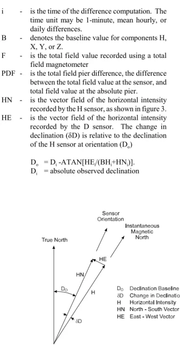
Magnetic observatories use a variety of magne-tometers, electronics, and computer processes to obtain component values of the Earth's magnetic field at 1-minute intervals. The component values recorded de-pend on the type of variometers used and the orientation of the variometer sensors. A vector diagram of compo-nent relationships is shown in figure 1. The reliability of component values may be influenced by many factors: - orientation of variometer sensors
- stability of variometer piers
- filter techniques used in digitizing values
- temperature coefficients of variometer sensors and electronics
- background noise of sensors and electronics - orthogonality of variometer sensors
- application of absolute controls
The instruments, electronics, computer processes, and observatory procedures are selected to minimize the negative effects of the above factors. Quality control procedures should be used to monitor these influences. Component baseline values are computed from absolute measurements and digitally recorded component values. Absolute values of the Earth's magnetic field are measured by an observer and the accuracy of the absolute values depend on several factors:
- observer skill and absence of bias
- calibration of magnetometers - accuracy of p